Damnoen Saduak Floating Market – Bangkok or Disney’s Epcot Center?

January 2017 – On our first days in Bangkok, Thailand, we got a huge kick out of everything we saw around us, because it was so familiar yet so different. We went to the 7/11 store (yup, 7/11 is huge in Thailand and can be found on every street corner) and we picked up one of every kind of beer they had in the cooler.

Beer in Thailand

A selection of Asian beers!

The beers are decidedly a lot lighter than we’re used to consuming at home, but what fun it was to sample such a wide variety. Three of them were named for large cats, from Leo beer to Singha (which refers to a mythical lion in Thai folklore) to Tiger beer (originally from Singapore)!

Lay potato chips are also easy to find everywhere, and what an interesting way Pepsico has modified the familiar red and white label on the bag to give it a Thai twist.

Lay Potato Chips Thailand

Same same, but different!
(the chips themselves are identical)

Mass market food products are a part of most cultures nowadays, but we wanted to try to get a little deeper than that in our introduction to Thailand. However, uncovering the “real” Thailand proved a little elusive at first.

In the olden days of a hundred years and more ago, Bangkok was a city of canals. “Floating markets” held aboard open boats were commonplace. However, since then, most of Bangkok’s canals have been filled in to make way for traditional roads and wheeled vehicles.

There are still many floating markets to be found, but they are a bit contrived as they are intended more for tourists to experience a touch of the bygone Thai culture than for Thai people to peddle their wares to each other.

Longtail boat floating market Bangkok Thailand

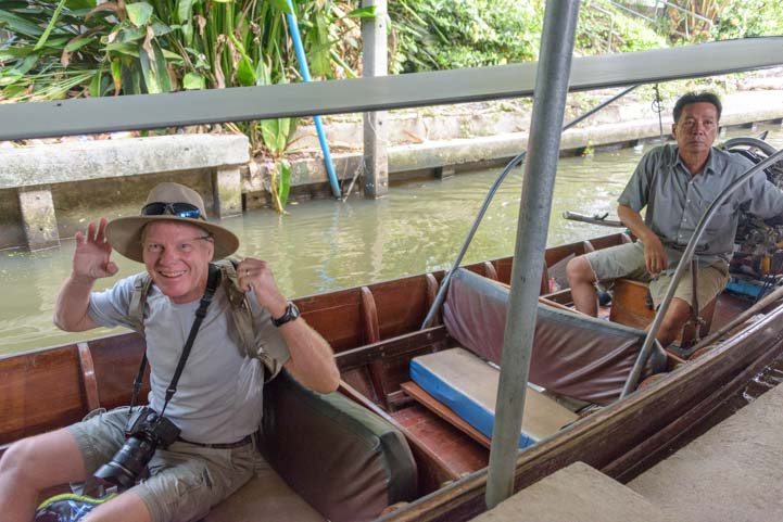
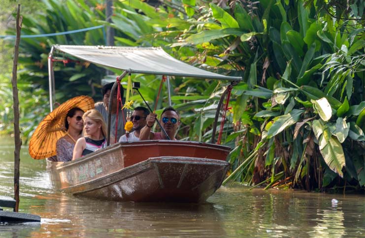
Mark gets in a longtail boat for a tour of a floating market

I searched high and low for an “authentic” floating market, and found one called the Tha Kha Market just outside of Bangkok that seemed like it would fit the bill.

Longtail boat damnoen saduak floating market Bangkok Thailand

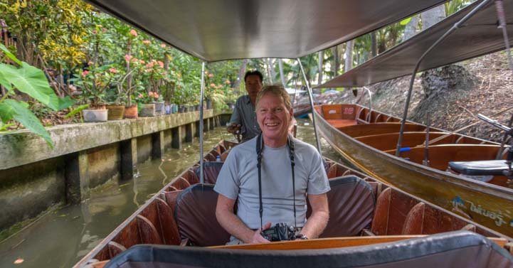
All smiles as we started down the canal.

We hopped in a cab to make our way out to this unusual sounding market, but were alarmed when we drove right by the signs for “Tha Kha Market” and arrived at the parking area for the known-to-be-touristy Damnoen Saduak Floating Market instead.

I chastised the driver for taking us to the wrong place, but he kept insisting this market was better, especially for photography. In the end we relented and hopped in a longtail boat and were piloted along a canal system.

The jungle was thick, and the ride was actually very cool.

Longtail boat canal damnoen saduak floating market Bangkok Thailand

We cruised down the canal through dense jungle vegetation.

We passed the homes of people who live on these canals.

House Damnoen Saduak Floating market Bangkok Thailand

A different kind of waterfront life.

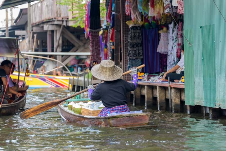
Then we arrived at our first “store.” A series of shops stood right on the water’s edge, tucked under a wide corrugated metal roof overhang, and vendors sat in each stall.

Shopping Damnoen saduak floating market Bangkok Thailand

The first of many canal-side shops.

Damnoen saduak floating market Bangkok Thailand

Get your “spicies” here!!

Negotiating is a natural part of shopping in Thailand, and we’d heard that the standard patter is to ask the price, counter what the vendor says with something outrageously low, and then accept his counter if you want to buy the item.

Shops damnoen saduak floating market Bangkok Thailand

Negotiating is part of the fun and part of the deal!

We had come to this market with photography in mind, however, and we weren’t looking to make any purchases.

Our pilot slowed down a little as we passed each shop, and we admired the many items but simply shook our heads “no.” After all, we wanted our luggage to be able to meet the extremely stringent international weight guidelines on our flight home!

Damnoen Saduak floating market Bangkok Thailand

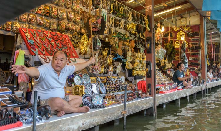
Trinkets, souvenirs and keepsakes of all kinds were for sale.

But in the days that followed, as we talked with other tourists around town, we realized that lots of people come to Bangkok specifically to shop, and many go to these floating markets hoping to score a deal.

Ironically, we found that the asking prices on many items at Damnoen Saduak Floating Market were ten times higher than in other places!
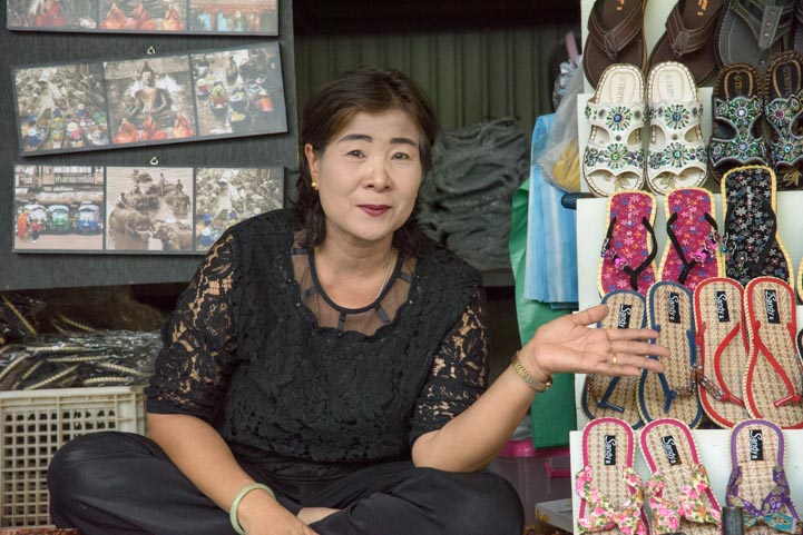
Sandals for sale Damnoen Saduak Floating Market Bangkok Thailand

Need some sandals??

We were surprised to see a monk out shopping too!

Buddhist monk shopping Damnoen saduak floating market Bangkok Thailand

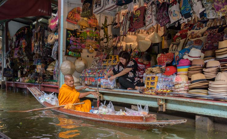
Shopping in Thailand might be a religious experience for some!

We had arrived at the Damnoen Saduak Floating Market very early, but soon we began seeing boats filled with other tourists.

Tourist shoppers Damnoen Saduak Floating Market Bangkok Thailand

A boat full of happy shoppers passed us.

We joked with each other that we were a long ways from home and never would have seen something like this if we’d gone to Quartzsite for the RV show as we have so many times in Januaries past! Even with inadvertently getting caught in a tourist trap, we were having a blast!

Woman vendor damnoen saduak floating market Bangkok Thailand

.

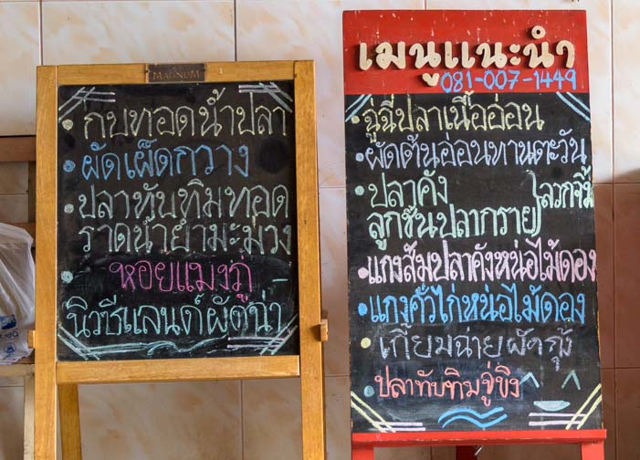
Besides trinkets sold in the shops along the sides of the canals, many vendors were cooking things in their boats and selling various edible goodies to passersby.

Woman cooking in boat damnoen saduak floating market Bangkok Thailand

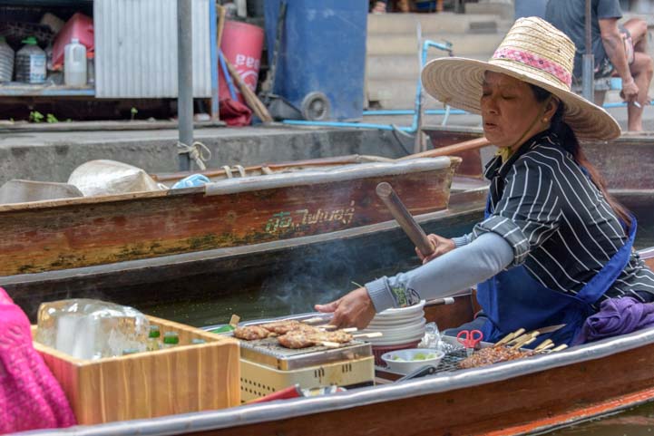
Some vendors cooked delicacies right on their boats.

Boat selling produce Damnoen Saduak Floating Market Bangkok Thailand

Food of all kinds was for sale.

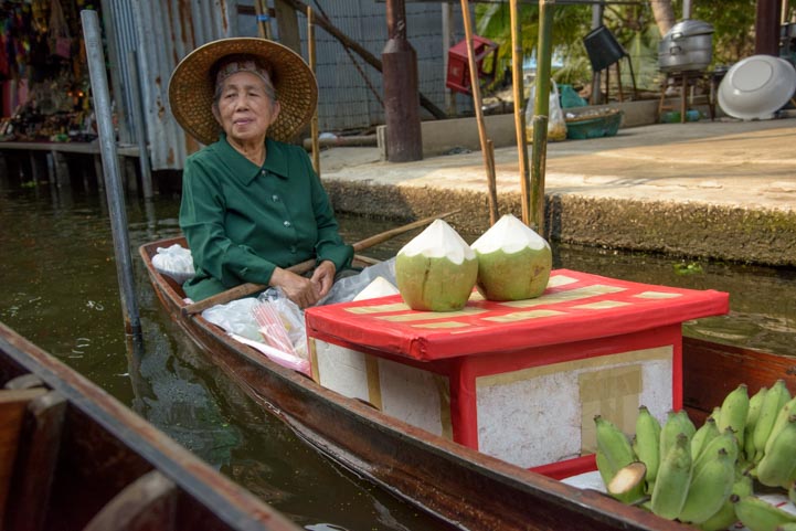
Beautiful tropical fruits and veggies were on full display.

Fruit for sale damnoen saduak floating market Bangkok Thailand

Fruit for sale!

Women at damnoen saduak floating market Bangkok Thailand

Veggies too!

As the morning wore on, the canals became busier and busier as vendors and tourist boats passed each other continuously.

Lady Damnoen Saduak Floating Market Bangkok Thailand

Coconut drinks.

Veggies for sale Damnoen Saduak Floating Market Bangkok Thailand

.

It was a little early for a beer, but some tourists imbibed as they floated along.

Beer for sale Damnoen Saduak Floating Market Bangkok Thailand

A Singha beer for you??

Of course, the display of traditions from long ago was just a show, and modern life lurked just out of sight.

On the cell phone damnoen saduak floating market Bangkok Thailand

Sometimes even the best displays of tradition include a fast-forward to the modern era.

Vendor on cell phone damnoen saduak floating market Bangkok Thailand

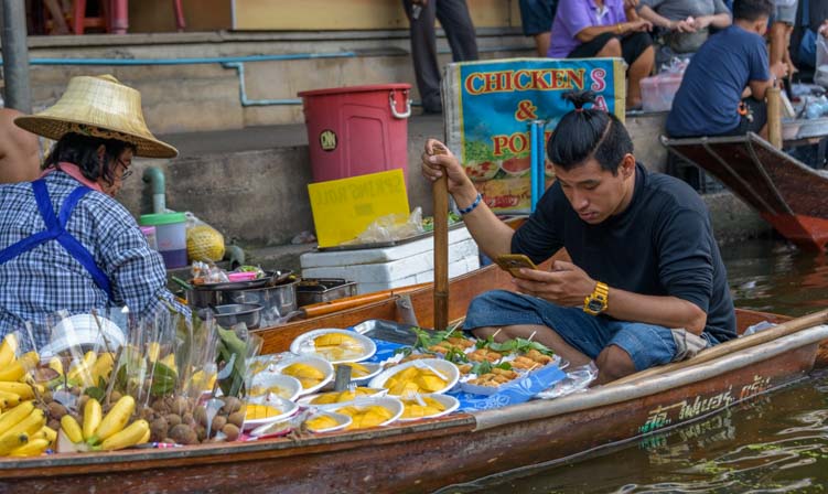
A quick Facebook check between sales.

The Damnoen Saduak Floating Market could easily be a showpiece at Disney’s Epcot Center, but experiencing it on the outskirts of Bangkok gave it a certain kind of realism.

And what fun it was to immerse ourselves in an event that hints at a lifestyle lived long ago.

Tourists damnoen saduak floating market Bangkok Thailand

Slipping through the jungle on the canals was truly wonderful.

Little boy Damnoen Saduak Floating Market Bangkok Thailand

.

As we putted back to the parking area in our longtail boat, we passed some men holding jungle critters for us to see up close.

Furry animal Damnoen Saduak Floating Market Bangkok Thailand

.

Snake charmer Damnoen Saduak Floating Market Bangkok Thailand

Snake charmer.

As our taxi driver took us back to Bangkok, we passed signs for the Tha Kha market, the slightly more authentic floating market that I had originally wanted to go to. I tried to find out from the cabbie exactly why he hadn’t taken us there but couldn’t really understand his response.

Damnoen saduak floating market Bangkok Thailand longtail boat

The Damnoen Saduak Floating Market was a very fun excursion even if it wasn’t particularly authentic!

When we returned to our hotel, I asked the concierge about the Tha Kha market. I pointed out its location on the map and he called over some colleagues to discuss it with them. In the end, they all agreed that the Tha Kha market had been closed and there was nothing there to see any more.

Whether the Tha Kha Market is truly closed — or whether we were taken to a more touristy market in hopes we’d buy a few things — the Damnoen Saduak Floating Market was a great spot for photography and made for a memorable morning.

Subscribe
Never miss a post — it’s free!

Other blog posts from our travels in Thailand:

More info about the Damnoen Saduak Floating Market:

Fun markets we’ve visited in our travels:

Our most recent posts:

More of our Latest Posts are in the MENU.
New to this site? Visit RVers Start Here to find where we keep all the good stuff!!

<-Previous || Next->

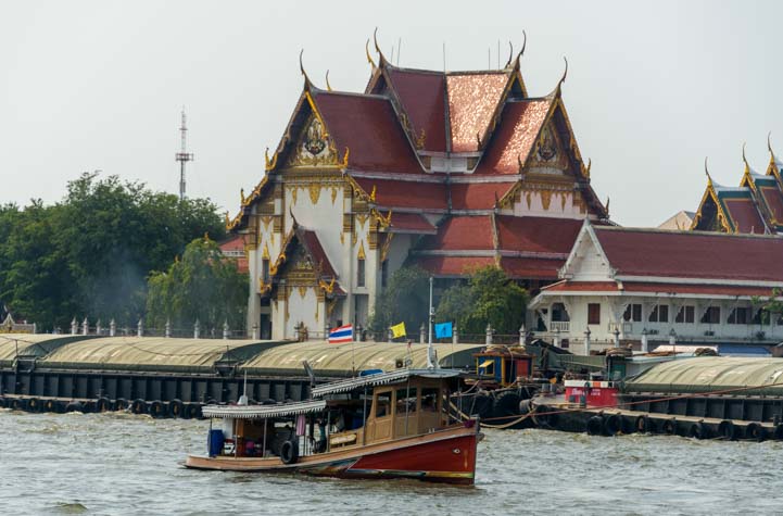
One Day in Bangkok – A trip on the Chao Phraya Tourist Boat!

January 2017 – When we moved off our sailboat and back into our trailer three years ago, the main reason we ended our sailing cruise of Mexico was that we’d found exotic travel to tropical destinations was a lot easier by airplane than by boat. Many of our dream destinations were hard to get to in a sailboat!

Boat on Chao Phraya River Bangkok Thailand

River views from the Chao Phraya River in Bangkok, Thailand

Yet, the last exotic foreign destinations we’d visited were all in Mexico during that cruise. We hadn’t made good on our promise to ourselves to get on planes and fly to cool places!

So, last week we hopped on an airplane and flew to Bangkok, Thailand. We will be touring around the country for a month.

If you haven’t looked for Thailand on a map lately, it is located in Southeast Asia, bordered by Laos, Cambodia, Malaysia and Burma (Myanmar):

Southeast Asia Map

Southeast Asia

Bangkok, the capital of Thailand, is very close to the Gulf of Thailand, and a long skinny portion of the country drops south between the Gulf of Thailand and the Andaman Sea:

Thaland and Cambodia Map

Thailand

This was all news to us when we started thinking about going to Thailand a few months ago, as the only thing we knew about the country was that everyone we’ve ever talked to who’s been there absolutely loved it.

RVers we met in Montana last summer told us about the many happy winters they’d spent visiting Thailand, and a loyal reader of this blog who has lived in Thailand for 10 years encouraged us to throw caution to the wind and check it out.

So, I jumped into researching places to go in Thailand and came up with a four week plan that will hopefully introduce us to many beautiful facets of this country.

Of course, the first hurdle to all of it was getting through 28 hous of travel door-to-door. When we stepped off the plane in Taipei after 13 straight hours in impossibly tiny seats (the width of the seats, from armrest to armrest, was the length of my forearm from elbow to fingertips), we were bleary eyed.

But how exciting it was to realize we had actually arrived in Asia!

Welcome to Taipei

We landed in Taipei, Taiwan, for a layover – We’re in Asia!

Once we finally got out on the streets of Bangkok, stumbling all over ourselves from lack of sleep, we were instantly caught up in the vivid sights and sounds and smells of downtown Bangkok as scooters, buses, tuk-tuks and intrepid bicyclists jammed the streets around us.

It felt like we were back in Mexico, except the writing on the signs was totally different!

Bangkok Thailand Road Sign

Thank goodness for the hints in English!

Thai menu in Thailand

What would you like for lunch?

We’ve been told that Thailand has two seasons: Hot and Hotter. We were there in the Hot season of January, so the daily highs were a balmy 90 degrees with 70% humidity, quite a change from the cool and dry Arizona desert climate in mid-winter.

Street vendor Bangkok Thailand

A Bangkok street vendor grins at me as he walks by

The locals were all cool as cucumbers, though, and motorbikes lined up at every Intersection as if they were at the startling line of a race.

Motorbikes line up at intersection in Bangkok Thailand

Motorbikes lead the pack in Bangkok’s notorious traffic.

Street vendors were selling food and drinks of all kinds and exotic smells filled the air.

Street Food Bangkok Thailand

We found street food everywhere in Bangkok

Bangkok is known as Krung Thep (กรุงเทพ), or the City of Angels, just like Los Angeles. But an aspect of its soul may be closer to Las Vegas’ Sin City.

I found myself humming the 1980’s son, “One Night in Bangkok” and looked up the lyrics and YouTube video only to learn that it was written for the musical “Chess” and talks of the irony of a nerdy international chess tournament being held in this city of sensual pleasures.

A hundred years ago or so, Bangkok was considered the Venice of the East, as it was built on a canal system and everyone got around town by boat.

On our first full day in Bangkok, we wanted to get an overview of the city as it looks from the water. So we took the Skytrain from our hotel to the public boat pier on the Chao Phraya river near Saphan Taksin station. Mark made his way through the many buttons on the Skytrain ticket machine, and we joined the throngs that travel through Bangkok by train everyday.

Getting train ticket in Bangkok Thailand

Bangkok’s Skytrain is super easy to use.

Chao Phaya Tourist Boat is a hop-on-hop-off ferry system that is just 150 Thai Baht (about US $4.50) per day. Perfect! Within moments we were out on the water.

Boats and buildings Chao Phraya River Bangkok Thailand

The Chao Phraya river runs through downtown Bangkok

Boats of all kinds were zooming up and down the river. There was so much boating action that the water was choppy from all the wake!

Boats on Chao Phraya River Bangkok Thailand

Bangkok’s Chao Phraya River is busy!

But the sights — oh my. Between the temples and highly ornamented buildings on the shoreline and the exotic boats plying the water of the river, we knew we had arrived in another world!!

Boat and temple Chao Phraya River Bangkok Thailand

We loved the classic images that surrounded us on the Chao Phraya Tourist Boat ride.

Boats seen from the Chao Phraya Tourist Boat Bangkok Thailand

What a great scene!

Thailand is a monarchy, and the much adored King Bhumibol Adulyadej (formally crowned King Rama IX of the Chakri dynasty) who ruled the Thai people for the last 70 years just died in October at age 88. Images of him, his 65 year old son who will replace him, and his wife are absolutely everywhere.

From splash screens across Thai websites to shrines in front of businesses built in his memory to billboards on the highways to the black pins and black clothing that many Thai people are wearing for a year of mourning, the sadness of this man’s passing is ever present.

On the Royal Thai Navy Headquarters building we saw portraits of the royal family.

Royal Navy Headquarters Chao Phraya River Bangkok Thailand

Portraits of the royal family at the Royal Navy Headquarters.

There were all kinds of unusual sights to be seen all along the river’s edge.

Sighting on Chao Phraya River Bangkok Thailand

.

In the distance, we saw the spires of the Grand Palace appear over the rooftops.

Boat and Grand Palace Chao Phraya River Bangkok Thailand

Grand Palace spires peak over the roofs.

We got off at this stop to explore a little. As we made our way from the pier to the main street, we passed a creative display of bicycles hanging on a wall.

Bikes on a wall Bangkok Thailand

.

The throngs of tourists surrounding the enormous city block that makes up the Grand Palace was intense.

It was a Saturday, and thousands of people filled the streets in all directions. Many were Asian tourists led by a strident person out front holding a flag high in the air to keep the group together.

A passing Buddhist monk caught my eye.

Buddhist monk Bangkok Thailand

.

The Grand Palace was built in 1782, and the spires of its many buildings in the complex rose above the high white wall that encloses the palace grounds.

Grand Palace spires Bangkok Thailand

Peaks of the Grand Palace

Mark and I had to laugh as we snapped endless pics. Two days earlier we’d been boondocking in Arizona. Now we were in Bangkok!

Tourist at Grand Palace Bangkok Thailand

OMG – We’re in Thailand!!

In order to approach the entrance gate to the Grand Palace, we had to show our passports and walk through a metal detector and get wanded. From there we moved into a massive line outside the gate to buy tickets.

Ornate rooftop Grand Palace Bangkok Thailand

.

Grand Palace views Bangkok Thailand

.

There is a strict dress code for visitors to the Grand Palace — elbows and knees must be covered — and even though officials would lend us cover-ups, our hearts weren’t into touring the palace just yet. There was still so much to see on the river.

Ministry of Defence Grand Palace Bangkok Thailand

Ministry of Defence at the Grand Palace

So, we made our way back to the Chao Phraya Tourist Boat at the pier where a breeze on the water made the sultry heat bearable.

Up ahead, a public ferry boat passed us as we approached one of the modern suspension bridges that crosses the Chao Phraya River. These boats are just 40 Thai Baht (about $1.15 US) for a point-to-point ride, and we saw a few foreigners (“farangs”) taking these ferries. But to us, the few dollars more for an all day hop-on-hop-off pass on the tourist boat was worth every penny.

Boat and suspension bridge Chao Phraya River Bangkok Thailand

A public ferry boat is dwarfed by a towering suspension bridge.

Compared to the public ferries which were packed, there were no lines at the piers for the Chao Phraya Tourist Boats. The wait for a boat was never longer than a few minutes, there was always plenty of room on the boat, and we could listen to narration about what we were passing on the shore.

Lots of room on Chao Phraya Tourist Boat Bangkok Thailand

The “hop-on-hop-off” tourist boat wasn’t crowded and we never had to wait long to catch it.

As we floated along the river, we loved the juxtaposition of the old style boats, the historic Thai temples and the modern highrise business buildings.

Temple and highrise building reflections Chao Phraya River Bangkok Thailand

Reflections: Old meets new and East meets West.

Tourist Boat and suspension bridge Chao Phraya River Bangkok Thailand

Views from the river in Bangkok.

Temple and boat Chao Phraya River Bangkok Thailand

Getting out on the river is a great way to see the shore.

Lots of people live on the river’s edge, and we passed a few housing blocks where laundry was hanging out to dry.

Houses on Chao Phraya River Bangkok Thailand

Houses along Bangkok’s Chao Phraya River

The Chao Phraya river is very dirty, and a few large patches of leaves and debris floated past.

Debris and Houses on Chao Phraya River Bangkok Thailand

.

One man’s trash is another man’s treasure, though, and we noticed an egret standing in the middle of one debris pile.

Egret in trash on Chao Phraya River Bangkok Thailand

.

There are dozens of ways to get out on the Chao Phraya River in Bangkok, as many of the big city hotels offer their own tours for their guests and private longtail boats offer tours not only on the main river but onto some of the smaller canals too.

Longtail boat Chao Phraya River Bangkok Thailand

Tourists can take rides on longtail boats and float up some of the smaller canals.

These private tours can cost as much as 1,600 Thai Baht, or about $45 for an hour of driving around. For us, the Chao Phraya Tourst Boat with its all day hop-on-hop-off service was a much better deal!

Longtail boat Chao Phraya River Bangkok Thailand

Longtail boats offer private rides.

Getting out on the water in the Chao Phraya Tourist Boat is a great way to get an overview of Bangkok.

Longtail boat Bangkok Thailand Chao Phraya River

.

The Chao Phraya Tourist Boat makes 8 stops along the river. We started at the Sathorn Pier near the Saphan Taksin BTS (Skytrain) station (station #S6). After getting off the train, we simply walked down to the street level and asked a BTS station official which way to go to get to the pier.

After a short walk to the pier, we walked past the enormous line of people waiting to take the cheaper ferry boat and ignored the many vendors selling expensive longtail boat rides and made our way to the well marked “Tourist Boat” loading dock at the end.

BTS Map Bangkok Thailand

BTS Skytrain map. Chao Phraya Tourist Boat stops at Sathorn Pier next to Saphan Taksin station (S6) on the southern line.

Subscribe
Never miss a post — it’s free!

More info about Chao Phraya Tourist Boat:

Blog Posts from Other Tropical Winter Escapes in the Caribbean:

Our most recent posts:

More of our Latest Posts are in the MENU.
New to this site? Visit RVers Start Here to find where we keep all the good stuff!!

<-Previous || Next->

Zion National Park “West” RV Trip – Gorgeous Kolob Canyons!

October 2016 – Zion National Park in Utah is one of America’s most beautiful National Parks, and we were loving our RV trip to the main part of the park at Zion Canyon. A side trip to Kolob Canyons at Exit 40 on I-15 took us to a much less visited but equally dramatic area on the west side of the Park.

Kolob Canyons Road Scenic Drive Zion National Park Utah

Kolob Canyons Road is a spectacular scenic drive.

The stunning scenic drive through the Kolob Canyons region of the park is truly breathtaking.

We had been blown away by the fall foliage season on the San Juan Skyway in Colorado in late September where the aspen trees were cloaked in gold. Autumn comes four or five weeks later in Zion National Park, but the colors in the last days of October were wonderful.

Autumn Foliage Taylor Creek Trail Kolob Canyons Zion National Park Utah

The trees were vivid colors.

As we followed Kolob Canyons Road, Taylor Creek accompanied us. Hardwood trees along the edges of this thin trickle of water were resplendent in their fall colors.

Fall Foliage Taylor Creek Trail Kolob Canyons Zion National Park Utah

Fall foliage was at its peak in late October – Wow!

The red rock scenery was awe-inspiring too, with jagged cliffs towering in front of us and then surrounding us.

Fall Foliage Kolob Canyons Zion National Park Utah

Kolob Canyons

Autumn Leaves Kolob Canyons Zion National Park Utah

.

There is no shuttle bus on Kolob Canyons Road, and there is very little traffic, especially in the early morning. We stopped at several pullouts to take a deep breath and savor the incredible views.

Scenic Drive Kolob Canyons Road Zion National Park Utah RV trip

.

Kolob Canyons Visitor Center at the beginning of the scenic drive is at about 5,000′ elevation, and Kolob Canyons Road climbs about 1,000 feet to the Kolob Viewpoint at the end, about 5 miles down the road.

In comparison, Zion Canyon is at 4,000′ elevation.

So, there was a delicious mix of evergreens and deciduous hardwood trees that stand out against the red rock backdrop.

Kolob Canyons Red Rock Fall Foliage Zion National Park Utah

Fall foliage and red rocks – yum!

Red Rock Kolob Canyons Zion National Park Utah

Trees perched on outcroppings of the red rock cliffs.

Kolob Canyons is an awesome area for photography, and our cameras were going wild.

Photography Kolob Canyon Road Zion Canyon National Park RV Trip

.

Some of the best fall colors seemed to be down along Taylor Creek, so we decided to hike the Taylor Creek Trail to see if we could immerse ourselves a little deeper in the fall foliage.

Taylor Creek Trail Kolob Canyons Zion National Park Utah RV trip

The Taylor Creek Trail headed right into the fall color.

Taylor Creek Trail was an easy hike that took us under lovely archways of colorful leaves.

 Fall Color Taylor Creek Hike Zion National Park Kolob Canyons

We walked under an arch of autumn color.

We had the trail almost entirely to ourselves as we walked into a wonderland of fall color.

Taylor Creek Trail hike Zion National Park Kolob Canyons

.

Because the elevation in Kolob Canyons is slightly higher than in Zion Canyon, late October was the ideal time to see the autumn colors along this creek.

Autumn color Taylor Creek Hike Zion National Park Utah

.

Red rocks autumn leaves Zion National Park Kolob Canyons

.

Being there at the right time for beautiful colors was a nice surprise, because, over in Zion Canyon we had found we were just a little bit early. The best time for that part of the park is the first week of November.

Fall Color Taylor Creek Trail Kolob Canyons Zion National Park Utah

.

Fall Foliage Kolob Canyons Zion National Park Utah

.

The red rocks of the surrounding peaks of Kolob Canyons jutted into the brooding sky, adding a wonderful burnt orange to the brilliant shades of the trees around us.

Taylor Creek Hike Zion National Park Kolob Canyons

.

We were just having too much fun with our cameras here!

Photography in Fall Colors Zion National Park Utah

.

As is always the way when we go on a gorgeous hike with our cameras, we soon got separated as we each scrambled off the trail here and there to explore inviting and hidden spots. Mark found himeself surrounded by maple trees and had fun with their bright red leaves.

Maple Leaf and acorn from Zion Canyon

Fall comes to Zion National Park.

Who knew there were maple leaves in the red rock desert canyons of Southern Utah?!

Colorful autumn leaves Zion National Park Utah

.

We spent many hours on Taylor Creek Trail and didn’t even make it to the end of the hike!

Autumn colors Taylor Creek Trail Hike Zion National Park Utah

.

Keeping tabs with each with our two-way radios, we finally made our way back to our truck. When I got there I found Mark had put pretty fall leaves all over my seat!

Autumn leaves in a truck

I came back to our truck to find my seat covered with fall leaves — fun!

It is days like this that make our crazy lives in our trailer so special.

Zion National Park RV Trip Kolob Canyons

.

For RVers heading to Zion National Park, the one hour drive from Zion Canyon around to the west entrance at Kolob Canyons is really worthwhile. There is a campground on the west side of the park that is designed for tent camping and is suitable for truck campers and very short Class C’s.

Camping Zion National Park Utah

A full moon rises at Zion.

There are links with more info and big rig RV parking ideas below.

Subscribe
Never miss a post — it’s free!

More info about Kolob Canyons in Zion National Park:

Blog posts from our RV trips to Zion National Park:

Blog posts from the area near Zion National Park:

Our most recent posts:

More of our Latest Posts are in the MENU.
New to this site? Visit RVers Start Here to find where we keep all the good stuff!!

<-Previous || Next->

Zion National Park RV Trip – One AWESOME Canyon!

October 2016 – Zion National Park in Utah is filled with towering rock formations that rise up alongside the Virgin River. It’s located in the heart of National Parks country, just 70 miles from Bryce Canyon National Park, 70 miles from Cedar Breaks National Monument and 110 miles from the North Rim of the Grand Canyon.

RV Camping on an RV trip to Zion National Park in Utah

Zion National Park is a fantastic destination for an RV trip

The views in Zion Canyon are utterly breathtaking.

View of Zion Canyon Zion National Park Utah RV trip

Zion Canyon view – spectacular!

We had visited Zion National Park before, both in a tent and also with our first full-time RV. But each of those visits had been more of a survey trip than an in depth immersion. This time we took our time exploring.

The Watchman Zion National Park Utah

The Watchman at sunset

There are many ways to enjoy Zion National Park. One of the most fun ways to get an introduction is to walk along the Pa’rus Trail that goes alongside the Virgin River right from the Visitors Center.

Hiking Pa'rus Trail Zion National Park Utah

We walked the Pa’rus Trail and crossed several bridges over the Virgin River

This is a popular trail both for walking (including dog walking) and for riding bikes as well.

Bike Pa'rus Trail Zion National Park Utah

Biking is a great way to get an overview of Zion National Park, especially on the Pa’rus Trail

We took our bikes on it one day and saw some fabulous views.

Bicycling Pa'rus Trail Zion National Park Utah

Cycling the Pa’rus Trail

Biking in Zion Canyon Zion National Park Utah

Pa’rus Trail – What a ride!

Rock pinnacles thrust up from the earth on all sides, and the trees were changing colors here and there in the cool October air.

The Watchman Zion National Park Utah

The Watchman in fall color.

We saw some little critters. A bird flitted between the branches of a tree and a ground squirrel paused to have a look at us.

Bird at Zion National Park Utah

.

Ground Squirrel Zion National Park Utah

.

The main road through the park is the 9 mile long Zion Canyon Scenic Drive which dead ends in the heart of the main canyon. Cars are restricted on much of this road and are forbidden for the last half of it from Spring to Fall, making it absolutely fabulous for a bike ride.

Bike Zion Canyon Scenic Drive Zion National Park Utah

Cycling Zion Canyon Scenic Drive into the heart of Zion’s main canyon: Zion Canyon

Cyclists share this road with both chartered tour buses and the Park’s free shuttle buses, but the buses are infrequent enough that for most of the ride we had the entire road to ourselves. Awesome!

Cycling Zion Canyon Scenic Drive Zion National Park Utah

We LOVED riding our bikes on Zion Canyon Scenic Drive

The erosive power of the Virgin River is responsible for Zion Canyon, and the stunning scenic drive runs alongside it.

Virgin River Zion Canyon Zion National Park Utah

The Virgin River cuts between the rock walls.

The Virgin River is shallow and filled with small rocks in some places.

Virgin River Zion National Park Utah

.

As we got deeper and deeper into Zion Canyon, the towering rock walls closed in all around us.

Virgin River Zion Canyon Zion National Park Utah RV trip

Tall cliffs and magical light in Zion Canyon

The canyon walls grew steeper and steeper, rising up around us on all sides as we approached the end of the road.

Bike Zion Canyon Scenic Drive Zion National Park Utah

Views everywhere

Early in the morning, much of Zion Canyon was in shade because the rock walls are so high.

Zion Canyon RV trip Zion National Park Utah

Light and shadow change all day long on Zion’s cliffs.

But later in the day the sun rose high enough to light it up. As the sun traversed the sky, the walls on one side of the canyon were lit first. Then they became shaded and the walls on the other side lit up.

Zion Canyon Scenic Drive Zion National Park Utah

A gorgeous view from Zion Canyon Scenic Drive.

Amazingly, Zion Canyon National Park has a brewpub right outside the park. After a day of sightseeing, no one had to twist our arms to join the other happy tourists and find a table with a view to quaff a pint!

Zion Brewery Zion National Park Utah

What a great way to unwind after a day of sightseeing.

Zion Canyon Brewing Company Zion National Park Utah

A brew with a view!

In the late afternoon we watched the full moon rise through the sunset.

Full moon Zion National Park Utah

.

Full moon Zion National Park Utah

.

Zion Canyon is essentially an enormous (and enormously beautiful) box canyon, i.e., a dead end. And Zion National Park is immensely popular. A ranger told me 4 million people had already visited the Park in 2016 when we got there in October.

So, getting all these people in and out of the box canyon is no small trick. Zion National Park has done an amazing job of handling the traffic and the crowds.

For starters, car traffic is highly restricted for all but the Winter season. The parking lot at the Visitor Center fills as early as 8:00 a.m. during the peak season between Spring and Fall.

RV Parking Zion National Park Utah

Forget about parking at the Visitors Center after 8:00 a.m.
Luckily, there is parking in the town of Springdale, especially at the south end of town.

There are two excellent free shuttle systems to ferry people around both the town of Springdale and Zion National Park.

The Springdale Shuttle takes visitors through town and runs all the way to the Zion National Park entrance and visitors center.

The Zion Canyon Shuttle takes visitors from there all the way through the National Park to the end of the box canyon (which is also the start of the very popular Narrows hike).

Shuttle Bus Zion Canyon Scenic Drive Zion National Park Utah

Free Shuttle Buses
The Zion Canyon shuttle (at bus stop #3 above) is efficient and easy to use.
A different shuttle — the Springdale Shuttle — serves the town of Springdale where you can park.
So… Park in town, take the Springdale Line to the Canyon Line which goes into the Park

There are about 9 stops on each route, and each one takes about 40-45 minutes end to end.

Passengers on the Zion Canyon Shuttle get to hear an interesting recording that tells all about the park, both its natural history and its human history. We took both shuttles quite a few times during our stay, visiting various overlooks and doing various hikes, and we found it easy and convenient.

Cars can drive into the park as far as the turn-off onto Route 9 East that goes through the Zion-Mt. Carmel Tunnel. People staying at Zion Canyon Lodge, which is beyond that point, can get a pass to drive as far as the lodge and park their cars there. However, during the peak season when the shuttle runs (Spring to Fall), all cars are forbidden beyond the Lodge. During the Winter, the shuttle runs only on holidays, and at that time cars are allowed to drive the full length of Zion Canyon Scenic Drive.

Anyone entering the canyon with a big dually truck like ours, or towing a trailer or driving a motorhome, will be informed that their vehicle will require a pilot to go through the Zion-Mount Carmel Tunnel on Route 9. There is a fee for this, as traffic in both directions has to be stopped. Years ago, we went through the Zion-Mt Carmel tunnel and drove the wild switchbacks of Route 9 in a minivan, and the drive is out of this world. So, if you have a car, do it!!

South Campground camping Zion National Park Utah

South Campground is right next to the Pa’rus Trail

There are two campgrounds that can accommodate small to mid-size RVs. Both are close to the Park entrance. South Campground is, ironically, the more northerly of the two. Watchman Campground is the more southerly one!

During our stay in October, the leaves were just beginning to change into their autumn colors. The peak for fall color is generally around the first week of November.

Fall color The Watchman Zion National Park Utah

Fall colors peak at Zion in the first week of November (this photo is late October)

RV trip Zion National Park Utah

.

Zion National Park is a world class destination and we absolutely loved our stay this year! We’ll have more blog posts from our time there. In the meantime, we’ve got lots of links below to help you plan your visit.

Zion Canyon RV camping Zion National Park Utah

Zion National Park is an incredible destination

Subscribe
Never miss a post — it’s free!

More info about Zion National Park:

Blog posts from our RV trips to Zion National Park:

Blog posts from the area near Zion National Park:

Blog posts from all our travels to National Parks and UNESCO World Heritage Sites in North America

Our most recent posts:

More of our Latest Posts are in the MENU.
New to this site? Visit RVers Start Here to find where we keep all the good stuff!!

<-Previous || Next->

Grand Canyon’s North Rim – Magnificent & Intimate by Day or Night!

October 2016 – After driving through the red rock wonderland of the Vermillion Cliffs in northern Arizona, we found ourselves at 10,000′ elevation on the Kaibab Plateau in beautiful pine forests. This is the home of the Grand Canyon where the earth seems to have split apart, revealing the massive crimson hued jagged walls that rise up from the Colorado River thousands of feet below.

Red cliffs of North Rim Grand Canyon Arizona

Red cliffs at the North Rim of the Grand Canyon

The Grand Canyon runs east to west for 277 miles and spans as much as 18 miles between its north and south rims.

A huge region towards the middle of the chasm has been set aside as Grand Canyon National Park, and it has two entrances you can drive to, one on the north side of the canyon and one on the south side. At each of those spots you can wander along the rim and peer over the edge to look 6,000′ down.

North Rim Grand Canyon Arizona view through trees

A glimpse of the Grand Canyon through the trees.

The South Rim is much more popular than the North Rim and is quite overrun with tourists, many making a once-in-a-lifetime bucket list trip from far distant corners of the planet. It is wonderful, but it is extremely busy.

Colorful cliffs North Rim Grand Canyon Arizona

View from the North Rim.

The North Rim of the Grand Canyon is a bit out of the way, so far fewer people go there, and most visitors are from the surrounding states. The North Rim sees 10% of the tourist traffic that the South Rim does and is 1,000′ higher in elevation.

Chasm North Rim Grand Canyon Arizon

Looking across the Big Ditch!

The North Rim has a very special lodge that was built by the National Parks Service in 1927. This wonderful and inviting stone building is perched right on the edge of the Grand Canyon, and the huge picture windows look out on a spectacular view.

View from Grand Canyon Lodge North Rim Arizona

The Grand Canyon Lodge at the North Rim – What a view!

There is also a huge dining room where diners can eat dinner while watching the sun cast its golden glow across the ridges of the canyon right next to their table!

Dining Room Grand Canyon Lodge North Rim Arizona

A historic and beautiful spot for a dinner…with a world class view!

Outside the lodge there is a low stone wall and a line of big wooden chairs where you can sit and take in the view over a beer.

View from deck of Grand Canyon Lodge North Rim Arizona

The deck behind the Lodge offers a relaxing spot to enjoy a drink and take a few pics.

What a fantastic place!

View from deck Grand Canyon Lodge North Rim Arizona

Tourists kick back at the North Rim.

There is a feeling of intimacy and wonder on the rim here as strangers chat with each other and snap pics and take in the incredible view, enjoying a unique National Parks experience.

Deck view North Rim Grand Canyon Arizona

.

A short trail leads from the edge of this deck out onto a peninsula that juts into the Canyon and ends at Bright Angel Point.

Hiking to Bright Angel Point North Rim Grand Canyon Arizona

The trail to Bright Angel Point at the North Rim

This is a fun paved path that provides endless opportunities for jumping up on the rock pinnacles on either side to get a better view.

Hke to Bright Angel Point North Rim Grand Canyon Arizona

There are lots of places to scramble a little higher for a better view.

Of course, the best light in the Canyon is early in the morning and late in the afternoon.

North Rim Grand Canyon Arizona View

Late afternoon’s golden light brings out the contours of the jagged cliffs at the Grand Canyon.

The sun was sinking in a very hazy sky when we were there, but the towering walls of the Grand Canyon still radiated a soft light, as if from within.

Golden hour North Rim Grand Canyon Arizona

.

North Rim Grand Canyon Arizona overlook

.

Rock formations North Rim Grand Canyon Arizona

.

Here and there couples and friends staked out a spot on a precipice to watch the sun fade away.

Sunset North Rim Grand Canyon Arizona

Catching the sunset at the North Rim of the Grand Canyon

As the shadows crept up the canyon walls from the bottom, the tips of the craggy peaks held the light the longest.

View of Red cliffs North Rim Grand Canyon Arizona

.

In the final few moments of daylight, a thin ribbon of orange hovered over the Canyon.

Chasm view North Rim Grand Canyon Arizona

.

As the sun sank deeper behind the horizon, the colors in the sky grew ever more rich.

Sunset North Rim Grand Canyon

.

Once the sun was gone from the sky, the contours of the Grand Canyon flattened out, revealing beautiful patterns.

Color Patterns North Rim Grand Canyon Arizona

Patterns in the view at the Grand Canyon after sunset.

Without any shadows to show depth, near and far blended together.

Patterns North Rim Grand Canyon Arizona

.

Cliffs North Rim Grand Canyon Arizona

.

Because of the 10,000′ altitude at the rim, the North Rim of the Grand Canyon is very cold, except in midsummer, and the Grand Canyon Lodge closes October 16. The 45 mile drive on Highway 67 between the hamlet of Jacob Lake and the North Rim remains open but isn’t plowed, and the self-service gas station in the park closes December 1.

In mid-October we shivered in overnight temps that dipped into the 20’s. Nevertheless, we snuck out onto the trail in front of the lodge in the pitch dark, lighting the way with our new and very cool Lumintop flashlight (we reviewed it here) and got set up to take some shots.

Overlook night stars North Rim Grand Canyon

Night photography at the North Rim of the Grand Canyon

Above us, the lodge was well lit and looked very cozy and inviting. Occasionally we heard the excited conversation of revelers out on the deck and saw flashes from their cameras.

Stars over Lodge at North Rim of the Grand Canyon starry night and fifth wheel trailer RV

The Lodge at the North Rim of the Grand Canyon.

Slowly the stars began to shimmer above us, forming a dome full of glitter over the Grand Canyon.

Stars at North Rim Grand Canyon Arizona

Stars began to fill the sky

Both rims of the Grand Canyon are decorated with the skeletons of dead trees whose gnarly branches reach out in all directions. The Milky Way formed a majestic backdrop in the sky.

Tree and Milky Way North Rim Grand Canyon Arizona

.

The moon was setting and slowly sank into the horizon. It was nearly full and glowed orange.

Milky Way at North Rim Grand Canyon Arizona

.

Seeing the moon at the horizon below the Milky Way reminded us of our many nights at sea on the Pacific Ocean. Sailors doing their first overnight passages are often shocked as they fly along in the pitch dark at full speed, squinting hard to distinguish the sky from the ocean, and then suddenly see a very bright light on the horizon right in front of them.

More than a few hearts have skipped a beat, and more than a few frightened sailors have dashed to their radar display in a total panic as they tried to figure out what kind of mammoth ship was about to crash into them.

Then they’ve suddenly collapsed in embarrassed laughter when they realized the enormous ship approaching them was actually the rising moon.

We’d read these stories before our cruise, and of course we knew we were far too smart ever to fall for Nature’s little nighttime tease. So, it was particularly funny when it happened to us too!

Milky Way at the Grand Canyon North Rim Arizona

Good night, Grand Canyon!

If the Grand Canyon is on your horizon for your RV travels, you can camp right on the rim in the campground at the North Rim. How totally cool is that?!

However, you need to have a small to mid-size RV to fit into the campsites and drive the camground loop, and it is best to reserve a spot in advance. There are other RV camping options for slightly bigger RVs in Jacob Lake.

For folks without an RV, the Grand Canyon Lodge has a collection of charming small cabins that surround the main lodge building, and they are just steps from the rim as well.

The North Rim of the Grand Canyon is quite vast, and many of the overlooks require a drive of 50 miles or so round trip to reach them. We breezed through the North Rim on this RV trip because it was late in the season and we couldn’t drive through Jacob Lake on our route from east to west across northern Arizona without dipping down to say “hi” to the Grand Canyon, if only for a moment.

However, like all the National Parks, the Grand Canyon deserves a week or more to enjoy its many nooks and crannies in depth. During our second year of full-time RV adventures, we stayed for a month at the North Rim.

More info and links below.

Subscribe
Never miss a post — it’s free!

Some details about Arizona’s North Rim of the Grand Canyon:

Other blog posts from our RV travels in Northern Arizona:

All of our blog posts from Arizona
National Parks and UNESCO World Heritage Sites we have visited

Our most recent posts:

More of our Latest Posts are in the MENU.
New to this site? Visit RVers Start Here to find where we keep all the good stuff!!

<-Previous || Next->

“Cliff Dwellers” on Arizona’s Vermillion Cliffs Scenic Drive – A Fun Stop!

October 2016 – Cutting across the northern part of Arizona from east to west in an RV is a total treat.

RV trip Vermillion Cliffs National Monument Arizona

An RV trip through the Vermillion Cliffs area in northern Arizona is a fabulous scenic drive.

We took US-95 south from Page to US-89A, and then followed US-89A northbound towards Marble Canyon, passing through the stunning red rock scenery of Vermillion Cliffs National Monument.

Driving through Vermillion Cliffs National Monument Arizona

Classic scenery in the Vermillion Cliffs of Arizona

The most spectacular section of this drive does a 180 degree turn on US-89A near Lees Ferry and Marble Canyon.

RV trip in Vermillion Cliffs National Monument Arizona

My camera never stops when we drive this part of US-89A!

Every time we pass through this region we are blown away by the scenery once again.

02 761 RV travel Vermillion Cliffs National Monument Arizona

.

As I was going through our photos this morning, choosing which ones to include in this post, I was amused to discover that a lot of the photos were essentially the sames ones I had taken from the passenger seat of our truck on previous trips through this area on our way to Kanab and Bryce Canyon years ago, and again this past spring of 2016 on our way towards the Canadian Rockies.

It is just that beautiful: even though I have the photos already, I’ve gotta take them again!

Motorhome RV in Vermillion Cliffs National Monument Arizona

RVing through the Vermillion Cliffs. Wow!

A stop at Marble Canyon and Lees Ferry is an absolute must. We loved visiting that area last spring.

This time, however, we wanted to see something new, and a small roadside stop called Cliff Dwellers was just the ticket. This is essentially a pullout located about 9 miles west of Navajo Bridge at Marble Canyon.

Pullout at Cliff Dwellers Vermillion Cliffs National Monument Arizona

The pullout at “Cliff Dwellers” on US-89A.

Boulders at Cliff Dwellers Vermillion Cliffs Arizona

The boulders at Cliff Dwellers are huge!

RV at Cliff Dwellers Vermillion Cliffs National Monument Arizona

.

We had no idea what we would find at this roadside stop in the middle of nowhere, but the first thing we saw was a towering mushroom red rock formation.

Rock formation Cliff Dwellers Vermillion Cliffs National Monument Arizona

A huge mushroom rock formation towers above me!

Red rocks at Cliff Dwellings Vermillion Cliffs Arizona

.

In the distance there was a rock structure.

Rock formation and rock house Cliff Dwellers Vermillion Cliffs Arizona

.

Whoever built this structure had placed red rocks on top of each other to form walls that fit under a huge overhanging mushroom type of boulder which formed part of the roof.

Cliff Dwellers Vermillion Cliffs National Monument Arizona

The rock building at Cliff Dwellers isn’t on a cliff, but it probably was a dwelling!

Rock house built into boulder Cliff Dwellers Vermillion Cliffs Arizona

The building is tucked under and overhanging boulder which provides part of the roof.

We prowled around the outside and inside of the building, peering through the windows and door.

Photography at Cliff Dwellers Vermillion Cliffs National Monument Arizona

View from the rock dwelling.

Windows at Cliff Dwellers Vermillion Cliffs National Monument Arizona

.

There were some beams that had once formed a ceiling over part of the structure.

Interior Cliff Dwellers Vermillion Cliffs National Monument Arizona

Simple living!

Off in the distance, we found a plaque that probably used to describe the history of the structures and the area, but the plaque was empty. So, we just enjoyed roaming around this odd structure.

Cliff Dwellers rock house Vermillion Cliffs Arizona

The rock house looks small compared to the huge red rock hill behind.

Behind it there was a fantastic red rock hill that had all kinds of striations and textures. Huge white boulders had come crashing down from one of the layers over the years, and they were strewn around the base.

Red rock cliff at Cliff Dwellers Vermillion Cliffs Arizona

Enormous rock boulders had fallen down the sides of this hill and lay around the bottom.

A Navajo woman had set up a folding table to sell jewelry to tourists who stopped by.

Navajo trinkets Cliff Dwellers Vermillion Cliffs National Monument Arizona

.

This little stopover at Cliff Dwellers was a fun way to spend an hour or two.

Cliff Dwellers red rocks Vermillion Cliffs National Monument Arizona

What a great little spot to take a breather in the middle of a truly gorgeous drive!

Motorhome Navajo trinkets Cliff Dwellers Vermillion Cliffs National Monument Arizona

Cliff Dwellers Roadside Stop on US-89A.

Continuing our drive west along US-89A, we came to the end of the red rock region where the red rocks of Vermillion Cliffs abruptly give way to the evergreens of the Kaibab Plateau.

RV at Vermillion Cliffs National Monument Arizona

.

Climbing up a series of tight switchbacks and steep grades, we arrived at a pullout near the top where we could take in the view in all directions and see this incredible transition in the landscape from red desert to green forest.

On one side there were beautiful yellow wildflowers that set off the red rock cliffs in the distance.

Wildflowers Vermillion Cliffs National Monument Arizona

.

There were also some beautiful pink fairy dusters in bloom.

Fairy Duster wildflowers Vermillion Cliffs Arizona

Pink fairy dusters.

Looking east back down the way we came, the road cut a cool s-turn through the desert.

Road in Vermillion Cliffs National Monument Arizona

Looking back towards the red rock cliffs.

And looking to the north, we saw the very cool divide between the red rocks of the desert and the green hills leading up to the very dense Kaibab forest that surrounds the Grand Canyon.

Red rocks and juniper hills Vermillion Cliffs Arizona

The red rocks of the desert give way to the greenery of the forested Kaibab Plateau which surrounds the Grand Canyon.

More about the Grand Canyon in our next post!! In the meantime, there are links for Vermillion Cliffs below.

Subscribe
Never miss a post — it’s free!

Info about the Vermillion Cliffs:

Other posts from our RV travels in Northeastern Arizona:

Other roadside attractions we’ve bumped into:

Our most recent posts:

More of our Latest Posts are in the MENU.
New to this site? Visit RVers Start Here to find where we keep all the good stuff!!

<-Previous || Next->

Cowboy Poetry Gatherings in Durango, Colorado, and Alpine, Texas!

October 2016 – One of the stops for RV travelers on the beautiful San Juan Skyway is the town of Durango, Colorado. This is a fun mountain town that is loaded with history. One of the most historic places in town is the pretty Strater Hotel.

Strater Hotel Durango Colorado

Strater Hotel in Durango, Colorado

As we walked down the streets in the historic district, we saw a wonderful horse and carriage parked near a store.

Horse and buggy ride Durango Colorado

Need a lift?

What fun it was to catch this rig a little later as it strutted down the road in front of the Strater Hotel!

Horse and carriage Durango Colorado

Shades of the past

Of course, Durango in the 21st century is quite different than back in the 19th century. A plaque on a street corner gave us a feeling for what this same area looked like back in 1896.

Durango Colorado Main Street 1896

Durango in 1896!

But the spirit of the old days is alive and well for Durango visitors, and I gave Mark a glimpse of what I’d look like as a barmaid at the famous Diamond Belle Saloon at the Strater Hotel.

Diamond Belle Saloon Strater Hotel Durango Colorado

.

Once we got inside the Diamond Belle Saloon, we saw the real thing. Much prettier!!

Barmaid Diamond Bell Saloon Strater Hotel Durango Colorado

The barmaids dress for success in the Diamond Belle Saloon in the Strater Hotel

The Diamond Belle Saloon was absolutely hopping when we stepped inside, because the Strater Hotel was hosting the annual Durango Cowboy Poetry Gathering.

Bar Diamond Belle Saloon Strater Hotel Durango Colorado

.

The barmaids were zipping between endless tables filled with cowboys, and the cash register was humming.

Strater Hotel Bar Durango Colorado

.

Mark has a knack for getting pretty girls to line up for photos for him (check out our blog post from Spring Break on Daytona Beach years ago), and these lovely ladies were happy to oblige his request for a photo.

Barmaids Diamond Belle Saloon Strater Hotel Durango Colorado

The Diamond Belle Saloon’s barmaids give us a smile!

If you don’t know what Cowboy Poetry is, you are in for a special treat when you get to a Cowboy Poetry Gathering.

Folks who love the western ranching lifestyle and people who are real live cowboys today get together and tell stories, sing songs and memorialize a way of life that is rapidly slipping away.

Don Cadden at Durango Cowboy Poetry Gathering

Cowboy poet Don Cadden sings us a song.

We are fortunate to be good friends with a popular cowboy poet, Don Cadden, a native Texan who heads up the enormous Cowboy Poetry Gathering ins Alpine, Texas, in February each year. Don has recorded many of his songs on CDs, and they are hauntingly beautiful (links below).

If you have ever felt nostalgia for a place that has changed with time, his song, “It Ain’t Texas Any More” will bring tears to your eyes (it does mine, and I’m not a Texan!). His poem “If Old Hats Could Talk” is a moving stroll through a row of old cowboy hats hanging on a wall that describes the personality of each hat and the story of the person that wore it.

Durango Cowboy Poetry Gathering

Cowboy Poetry is as much about music as it is about poetry!

The Cowboy Poetry Gathering in Durango fills every possible venue in the Strater Hotel and around town, as formal performances take place and informal groupings of friends play for each other in whatever nook or cranny they can find.

Don Cadden was scheduled to perform in the Diamond Belle Saloon, but the bar was so loud with reveling cowboys and cowgirls that he moved his group of perfomers to the hotel lobby where the audience could enjoy the music and be close to the performers. More than a few tourists coming into the hotel stopped to listen for a while before making their way to Reception or their rooms!

Cowboy Poetry Gathering Durango Colorado

Cowboy poets were performing all over the place in Durango even the hotel lobby!

We watched a more formal performance on a stage in the Strater Hotel where a group of cowboy poets took turns telling hilarious stories, reciting funny poems and singing songs.

Durango Cowboy Poetry Festival

Cowboy poets on stage regaled the audience with hilarious stories and songs.

Durango Cowboy Poetry Gathering Colorado

.

A common theme was the progression of modern day cowboy life — with its cell phones, Facebook and ATVs — away from the traditional ways of doing things around a ranch, in person and on a horse.

Even the oldest of today’s cowboys is fully connected to the world electronically, as we all are, and of course none of them are quite old enough to remember a time when the only connection between people across long distances was word of mouth, hand-written letters, newspapers, or the slick, newfangled telegraph system.

Durango Cowboy Poetry Gathering on stage

Nostalgia for earlier times without cell phones and Facebook were common themes in the poems and songs.

The really fun thing about the Cowboy Poetry Gathering is that there were cowboys all over the place, inside the hotel, outside the hotel, and strolling down the streets of Durango. Many of them talked with each other about their ranches and their horses as well as their music and poetry.

Cowboys Strater Hotel Durango Colorado Cowboy Poetry Gathering

Old cowboys chatted with each other when they weren’t performing.

We had a chance to talk to a very old cowboy who has been part of the cowboy poetry community for many decades.

Cowboy and cowgirl Durango Colorado

.

Of course, Durango is a pretty big city, and many of these ranchers had driven to town by truck. After all, Durango doesn’t really have any places to tie up a horse. But they do have cool bike racks!

Durango Colorado bicycle rack

Durango is a hip town with decorative bike racks on the parking meters.

We’ve been to Durango a few times over the years, and one of our favorite places to grab a microbrew beer is at the Steamboat Springs Brewing Company. We joined all the cowboys that had worked up a thirst from singing and went on in.

Steamworks Brewing Company Durango Colorado

Steamworks Brewing Company is an awesome place to wet your whistle!

After quaffing a few, we mosied through town and came across a very funny sign:

Beauty is in the Eye of the Beer Holder

.

If you are planning a Fall RV adventure in southwestern Colorado or if your winter RVing plans will take you to southwestern Texas, going to one of these gatherings of cowboy poets is a real highlight.

A wonderful spot for an RV trip in the winter is Big Bend National Park in Texas where you can find a cowboy poetry gathering in nearby Alpine, Texas, each February.

The Fall 2016 issue of Coast to Coast Magazine includes a feature article I wrote about our RV trip to Big Bend National Park and is decorated with photos from both of our cameras during our stay there.

Mark’s photo of the balancing rock on the Grapevine Hills Hike is on the cover of the magazine:

Coast to Coast Magazine Fall 2016 Cover Photo Big Bend Texas by Mark Fagan

Cover photo: Mark Fagan
Fall 2016 issue

Big Bend National Park has mountains, deserts and a big ol’ river (the Rio Grande), which makes for an incredible variety of options for hiking, cycling, photography and sightseeing.

On the beach Santa Elena Canyon Big Bend Texas

Santa Elena Canyon on the Rio Grande in Big Bend National Park, Texas

There is also a ghost town and a very funky hippie town in Terlingua on the far western edge of the park.

Ruins in Terlingua Ghost Town Texas

Old adobe ruins from the Mexican mining camp in Terlingua, Texas, just outside Big Bend

And passport holders can slip across the border to Mexico in a rowboat and enjoy a daytrip to the classic Mexican town of Boquillas del Carmen, a place that we found offered as authentic a Mexican experience as any we had had in our nearly four years of living in Mexico on our sailboat.

Ferry across Rio Grande from Big Bend National Park to Boquillas del Carmen Mexico

Taking the ferry across the Rio Grande for a daytrip to Mexico.

Here are links to our blog posts from our RV travels in Big Bend National Park:

For more: All of our blog posts from our RV trips in Texas

RV Camping at Big Bend National Park Texas

Goodnight, Big Bend!!
Love boondocking? Visit our page: Tips for boondocking at Big Bend!

Subscribe
Never miss a post — it’s free!

More info about Durango and Cowboy Poetry festivals:

Other blog posts from our RV trips to Colorado:

Our most recent posts:

More of our Latest Posts are in the MENU.
New to this site? Visit RVers Start Here to find where we keep all the good stuff!!

<-Previous || Next->

Brilliant Fall Foliage + Snow in the San Juan Mountains of Colorado

September 2016 – Chasing the late September fall foliage season in Colorado’s San Juan Mountains high up at a lofty altitude of 10,000 feet brings hillsides filled with shimmering golden aspen leaves.

Fifth wheel trailer fall colors San Juan Skyway Colorado Rocky Mountains

What a beautiful place for an RV road trip – The San Juan Mountains in late September!

Sometimes vivid colors sparkle in the sun, but fall in the Rockies can also bring snowstorms. We woke up one morning to whiteout blizzard conditions and soon found our RV surrounded by three inches of snow

Snow in the Colorado Rocky Mountains San Juan Skyway

Hey, it’s snowing!!

The fall foliage season in Colorado is spectacular when the sun is shining and the air is warm. But a layer of pure white snow makes it ever so much more dramatic.

Snow and fall colors San Juan Skyway Rocky Mountains Colorado

Fall color in the snow… beautiful!

The skies were gray and gloomy, but the leaves were vibrant and bright

Yellow aspen fall leaves San Juan Skyway Colorado Rocky Mountains

.

The temps in the mountains were bitterly cold, dropping into the twenties at night. This prompted us to run our furnace as well as our vent-free propane heater and put together a blog post about how to heat an RV in cold weather!

But it was oh-so-beautiful. The juxtaposition of spiky evergreens, trimmed in white snow, against a backdrop of vivid orange and yellow was sensational.

Orange aspen San Juan Skyway Colorado Rocky Mountains

.

The scenery in every direction was magnificent.

Autumn leaves fall color San Juan Skyway Colorado Rocky Mountain

.

Up close, each aspen branch held a little layer of snow.

Aspen leaves fall color San Juan Skyway Colorado

.

After the snow stopped falling, the wind blew, and the yellow and orange aspen leaves fluttered to the ground and settled on the snow.

Aspen leaves in snow

.

The craggy rocks on the mountainsides were covered with a lovely dusting of white lace.

Rocky Mountains in autumn San Juan Skyway Colorado

.

Autumn color aspen trees San Juan Skyway Colorado Rocky Mountains

.

Colorful hills San Juan Skyway Colorado Rocky Mountains

.

Out on the Million Dollar Highway, a portion of the San Juan Skyway that goes from Durango to Silverton to Ouray, the views from the passenger seat were awe-inspiring.

Million Dollar Highway autumn color San Juan Skyway Colorado Rocky Mountains

.

Snow on Million Dollar Highway San Juan Skyway Colorado Rocky Mountains

.

As the roads dried and people got back on the move in their cars again, we saw a few small trailers go by.

RV fall colors San Juan Skyway Colorado Rocky Mountains

Heading into the mountains.

Travel trailer San Juan Skyway Colorado Rocky Mountains fall color

.

The hillsides were blanketed in color everywhere we turned.

Aspen hillside fall color San Juan Skyway Colorado Rocky Mountains

.

Golden aspen and pine trees San Juan Skyway Colorado Rocky Mountains fall foliage

.

Pine trees and golden aspen San Juan Skyway Colorado Rocky Mountains fall foliage

.

The San Juan Mountains are part of the Colorado Mining Belt that was mined intensively for silver and gold in the late 1800’s and early 1900’s. The rivers in the area run orange from minerals leaching out of the tailings piles left behind by the mines.

Waterfall on the San Juan Skyway Rocky Mountains Colorado

The river water runs orange here.

After the snowfall, the reddish water was filled with snow covered rocks and surrounded by evergreens clad in white. Pretty!

Snowy River Colorado Rocky Mountains San Juan Skyway

The Uncompaghre River.

Eventually the clouds began to dissipate and patches of blue sky began to appear.

Snow and Autumn Color San Juan Skyway Rocky Mountains Colorado

Our truck is dwarfed by this incredible mountain. Yay for some blue sky appearing!

Snow and fall leaves Million Dollar Highway San Juan Skyway Colorado Rocky Mountains

.

 Rocky Mountain Fall Color San Juan Skyway Colorado

.

Autumn is gorgeous in many parts of the country, but fall in the Rocky Mountains in Colorado is utterly breathtaking.

The cool thing for RVers is that you can catch the fall colors in Colorado in late September and, if you’re willing to hustle, you can get to other beautiful areas in far distant states to catch their fall foliage show a week or two later in early to mid-October.

RV autumn leaves and snow San Juan Skyway Colorado Rocky Mountains

.

Aspen leaves in fall San Juan Skyway Rocky Mountains Colorado

.

We haven’t done that yet, perhaps sometime in the future. For this year, we savored the colors in Colorado, and were amazed that the mountains seemed to change shades right before our eyes.

Snowcapped mountains autumn leaves San Juan Skyway Colorado Rocky Mountains

.

Colorado Fall Foliage San Juan Skyway Rocky Mountains

.

The snow left puddles behind that reflected the trees around them

Reflections of autumn leaves and aspen trees San Juan Skyway Rocky Mountains Colorado

.

And all the leaves on the ground were covered with tiny water droplets.

Water droplets on golden aspen leaf

.

By the time we left this part of Colorado, our eyes were tired from staring so hard and taking so many photos!! But what a wonderful kind of fatigue it was.

San Juan Skyway Snowcapped Mountains autumn color Rocky Mountains

.

If you haven’t experienced a fall foliage season in the aspen filled Rocky Mountains of Colorado, it is something that deserves some special planning!

Snowcapped mountains fall folilage San Juan Skyway Colorado Rocky Mountains

Happy campers surrounded by astonishing scenery. How wonderful!!

Subscribe
Never miss a post — it’s free!

A few more resources for the San Juan Skyway in Colorado:

During the holiday shopping season, we would LOVE for you to visit Amazon via any of our links. What happens is anything you put in your shopping cart immediately afterwards results in a small commission to us at no cost to you, no matter what it is and no matter when you complete the purchase. This is a huge pat on the back for us, and the small trickle of referral fees from appreciative readers makes it justifiable and possible for us to put the time into this website that we do. Thank you!!

Info for Colorado’s San Juan Skyway:

Fun snowy and wintry blog posts from our RV travels:

Other blog posts from our RV trips to this part of Colorado:

More blog posts from our RV trips to Colorado:

Our most recent posts:

More of our Latest Posts are in the MENU.
New to this site? Visit RVers Start Here to find where we keep all the good stuff!!

<-Previous || Next->

Colorado’s San Juan Skyway – An RV Trip in Dazzling Fall Color!

September 2016 – During the last ten days of September each year, the San Juan Skyway in the Colorado Rocky Mountains becomes one of the most dazzling places we have ever visited with our RV.

RV on San Juan Skyway Colorado Rocky Mountains Aspen trees in autumn

Astonishing color on an autumn RV trip along Colorado’s San Juan Skyway. WOW!!

Beginning around September 20th and continuing through the first few days of October, this 235 mile long drive comes alive in utterly spectacular color.

San Juan Skyway Colorado Rocky Mountains Colorful valleys

Colorado fall color.

Towering mountains on either side of the road are covered in swatches of vivid color as the aspens don their golden cloaks.

Colorful hillside San Juan Skyway Colorado Rocky Mountains Autumn Leaves

Autumn splendor in the Colorado Rockies

Patches of yellow spring up in every direction, and as the days go by, green becomes yellow and yellow turns to vivid orange.

Fall color in Colorado Rocky Mountains

Patches of brilliance.

Color patterns San Juan Skyway Colorado Rocky Mountains Autumn Leaves

.

The trees join together and form patterns in the Rocky Mountains, and visitors carrying cameras of all shapes and sizes gape in awe at the splendor of Nature’s majesty.

 Leaf patterns in fall San Juan Skyway Colorado Rocky Mountains

.

In places, lakes reflect the glory of the mountains on their glassy surfaces, mirroring the stunning fall colors in their depths.

Crystal Lake in Autumn San Juan Skyway Colorado Rocky Mountains

.

Along with dozens of other grinning, camera wielding tourists, we stopped along Colorado’s jaw dropping Million Dollar Highway to take in the views and take some photos. It was early morning on a grey day, and we watched a duck swimming across a small lake.

Colorado Rocky Mountains Autumn Color San Juan Skyway Colorado

Vivid colors brighten a grey morning at Crystal Lake.

As she headed towards the shore, she swam into the reflected colors.

Duck Autumn color San Juan Skyway Colorado Rocky Mountains

.

The undulating surface surrounded her in golden ripples as she quietly floated across this magnificent backdrop.

Duck Fall color reflections San Juan Skyway Colorado Rocky Mountains

.

She stabbed the silky water with her beak, seeking out yummy morsels, and tiny water droplets fell from her beak as she turned.

Duck in autumn San Juan Skyway Colorado Rocky Mountains

.

The lake mirrored the vivid, patchwork hillsides in the water, creating a breathtaking image.

Aspens in fall San Juan Skyway Colorado Rocky Mountains

.

On the side of the lake, tourists set up camp chairs to admire the mountain views.

Leaf peepers San Juan Skyway Colorado Colorful valleys

.

And what a view they had.

Rocky Mountains Fall Color San Juan Skyway Colorado Colorful valleys

.

Both from a distance and from up close, the colors of the trees were awe-inspiring.

Mountains of gold San Juan Skyway Colorado Rocky Mountains

.

Fall color San Juan Skyway Colorado Rocky Mountains

.

Like Utah’s Scenic Byway 12, the San Juan Skyway is an All American Road. It is a loop drive that passes through some of Colorado’s most charming mountain towns.

Rico Colorado San Juan Skyway Rocky Mountains

Rico is one of many cute towns along the San Juan Skyway.

Beginning in Dolores, Colorado, the San Juan Skyway follows SR-145 northeast through the village Rico to the trendy town of Telluride.

Autumn color San Juan Skyway Rocky Mountains

Right from Crayola!

From Telluride, the San Juan Skyway continues northwest on SR-145 to the town of Placerville where it heads northeast again on SR-62 to the town of Ridgway.

Trees in autumn San Juan Skyway Colorado Rocky Mountains Autumn Leaves

.

From Ridgway, the autumn colors intensify as the San Juan Skyway turns south on US-550, also known as the Million Dollar Highway, and travels through Ouray and Silverton to Durango.

Starburst golden aspen autumn leaves San Juan Skyway Colorado Rocky Mountains

A fish-eye lens and a starburst – what fun!

This portion of the San Juan Skyway takes RVers on tight hairpin turns and 10% grades to climb over three mammoth mountain passes that range between 10,000 and 11,000 feet.

Reflections golden aspen autumn leaves San Juan Skyway Rocky Mountains

Stunning reflections and post-processing fun.

This is an extraordinary road that is easily traveled in an RV that has a strong engine or is towed by a strong truck (semi-tractor trailers traverse the Million Dollar Highway 24/7 in large numbers).

For first-timers, is worthwhile to drive the road in the toad or tow vehicle at least, just so you know what is in store. And who wouldn’t want to do this drive multiple times during those magical autumn days?!

San Juan Skyway Colorado Rocky Mountains Autumn Leaves

Heading up the Million Dollar Highway.

We have been fortunate to sample various portions of the San Juan Skyway on three separate occasions since we started RVing full-time. Each time we have been wide-eyed with wonder at the sensational scenery all around us.

Motorcycle in fall colors San Juan Skyway Colorado Rocky Mountains

San Juan Skyway – An INCREDIBLE drive!!

For RVers planning an RV trip on the San Juan Skyway, there are various informative links below.

Subscribe
Never miss a post — it’s free!

Further Resources:

During the holiday shopping season, we would LOVE for you to visit Amazon via any of our links. What happens is anything you put in your shopping cart immediately afterwards results in a small commission to us at no cost to you, no matter what it is and no matter when you complete the purchase. This is a huge pat on the back for us, and the small trickle of referral fees from appreciative readers makes it justifiable and possible for us to put the time into this website that we do. Thank you!!

Info for Colorado’s San Juan Skyway:

Other blog posts from our RV trips to this part of Colorado:

More blog posts from our RV trips to Colorado:

Our most recent posts:

More of our Latest Posts are in the MENU.
New to this site? Visit RVers Start Here to find where we keep all the good stuff!!

<-Previous || Next->

The Burr Trail – A Fabulous Side Trip on Utah’s Scenic Byway 12

September 2016 – One of the most beautiful side trips along Utah’s Scenic Byway 12 is another scenic drive that branches off of Route 12 at the small hamlet of Boulder, Utah. Its called the Burr Trail.

Overlook Burr Trail Scenic Byway 12 Utah

Looking out across the beginning of the Burr Trail

We first heard of this scenic back road from an old rancher who was a retired high school teacher and former football coach in Tropic, Utah, just outside of Bryce Canyon National Park.

As we leaned up against a fence with him, admiring his cows grazing in the distance, and listening to his tales of teaching and coaching back in the 70’s, he suddenly asked us if we’d ever driven the Burr Trail.

Boulder utah Post Office Burr Trail Scenic Byway 12

The post office in Boulder, Utah, where the Burr Trail begins.

We’d never even heard of it! But the more he talked about it, the more we knew we needed to check it out!

The little village of Boulder, Utah, has just a few buildings in it, so it is easy to drive right through it while barreling along on Scenic Byway 12.

But there’s a little store and an RV park, and there’s a post office that puts the town on the map. The turnoff to the Burr Trail is at the big 90 degree bend in Route 12 right by the Burr Trail Grill.

Boulder Utah RV Park  Burr Trail Scenic Byway 12

The Shopping District in Boulder, Utah

As soon as we drove onto the Burr Trail, the scenery went from ordinary to extraordinary in a matter of minutes.

Burr Trail Scenic Byway 12 Utah

Heading down the Burr Trail

The road is narrow. It’s fine for passenger vehicles but is not recommended for RVs. We drove it with our truck on a weekday, and during the morning to midday hours we were on our own and didn’t see any other travelers.

Scenery Burr Trail Scenic Byway 12 Utah

Views along the Burr Trail.

The rock formations became more and more dramatic with each mile that we drove.

Rock formations Burr Trail Scenic Byway 12 Utah

Gorgeous views at every turn!

Dead tree Burr Trail Scenic Byway 12 Utah

.

And then the canyon walls began to get very steep on either side of us as we drove down the middle of Long Canyon.

Canyon Walls Burr Trail Scenic Byway 12 Utah

.

The entire Burr Trail is 69 miles from end to end, but only the first 30 miles are paved. So, we drove until the pavement ended and then turned around and came back.

Cliffs Burr Trail Scenic Byway 12 Utah

Long Canyon has towering rock cliffs on both sides of the road.

On our way out on the Burr Trail, we had noticed a few cars parked on the side of the road at one spot. On our return trip, we stopped there to see what was going on.

It turned out to be a lovely but very short slot canyon!

Trees Long Canyon Slot Burr Trail Utah Scenicy Byway 12

Beautiful shade trees lead to a slot canyon

The first hundred feet or so of the slot canyon had a fantastic canopy of trees covering the trail, providing wonderfully cool shade at midday.

Slot Burr Trail Scenic Byway 12 Utah

These trees are actually very tall!

Then, after another few paces and a slight turn in the trail, the slot canyon suddenly ended.

Long Canyon Slot Burr Trail Utah Scenicy Byway 12

End of the trail.

Sometimes this canyon is called the Singing Canyon, and we quickly found out why.

A group of hikers was just coming out of the slot canyon as we approached, and they passed by us on the way to their cars out on the road. When we got to the far back end of the slot, out of sight of the road, the hikers had made it to their cars and were standing around in the road talking with each other.

Starburst Long Canyon Slot Burr Trail Utah Scenic Byway 12

The sun shines through the slot.

Amazingly, we could hear everything they were saying, as if they were on the opposite side of us, beyond the impenetrable back end of the canyon!

I didn’t believe the sound could bounce around like that at first, but as soon as they drove off in their cars, the echoes of conversation at the back of the canyon fell silent.

Singing indeed. You’ve gotta be careful what you say out loud by the road when your friends head into this slot!

The Long Canyon Slot Burr Trail Utah Scenicy Byway 12

This canyon has incredible echoes!
Here a starburst from the sun dwarfs me… cool!

At the mouth of the sot canyon there are some beautiful red rock formations that beg to be climbed. We obliged, of course!

Red rock formations Long Canyon Slot Burr Trail Utah Scenicy Byway 12

.

As we were leaving, we spotted the first signs of fall down on the ground. Yellow leaves were lying at the base of the tree trunks here and there.

Fall leaves and tree trunk

A golden harbinger of fall.

Back out on the Burr Trail, the rock formations were bright white and a rich burgundy red set off by dark green trees.

Red rocks and trees Burr Trail Utah Scenicy Byway 12

.

We drove back through Long Canyon and watched in awe as the canyon walls rose up around us once again.

Red rocks Burr Trail Scenic Byway 12 Utah

.

Motorcycles Burr Trail Scenic Byway 12 Utah

A pair of motorcycles takes in the view.

And then we were back in the open, sweeping vistas of the beginning of the Burr Trail.

What a drive!!

Wide vistas Burr Trail Scenic Byway 12 Utah

The Burr Trail is a wonderful excursion off of Scenic Byway 12 in Utah.

The Burr Trail is a really easy sidetrip for RVers traveling along Utah’s Scenic Byway 12, and is well worth taking a few hours to do.

Jewels like this are so easy to miss in this part of the world because the bigger, more famous stuff gets all the attention.

Thank goodness we met that old rancher in Bryce Canyon and hung out with him for a while by his fence, chatting about his cows, his former students and his football team, or we never would have learned about this beautiful place!

RV on Utah Scenic Byway 12

There are lots of gems for RVers on Utah’s Scenic Byway 12!

Subscribe
Never miss a post — it’s free!

More info about the Burr Trail :

Other posts from our RV trips on Utah’s Scenic Byway 12:

Blog posts from nearby Bryce Canyon National Park:

Our most recent posts:

More of our Latest Posts are in the MENU.
New to this site? Visit RVers Start Here to find where we keep all the good stuff!!

<-Previous || Next->