Lake Mead Scenic Drive + A Great RV Pit Stop at “Redstone” NV!

December 2017 – We try to avoid interstate highways and big cities in our RV lifestyle, and when we began our trek south from southern Utah towards Arizona a few weeks ago, we wanted to limit our time on I-15 and avoid the congestion and traffic of Las Vegas.

Fifth wheel RV trip to Lake Mead Nevada-min

We found a delightful scenic drive that skirts around Las Vegas!

We took a jog south off of I-15 onto Nevada Route 169 and followed the contours of Lake Mead all the way around to the southeastern side of Las Vegas. What a beautiful and delightful RV trip!

Lake Mead Nevada RV scenic drive-min

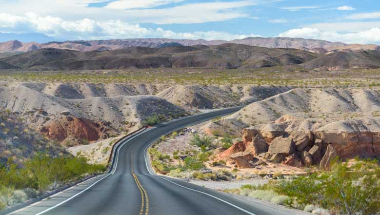
The road takes a wonderful journey through rocky and colorful terrain.

The road rose and dipped and swerved left and right, revealing gorgeous scenery all along the way.

RV scenic drive along Lake Mead Nevada shoreline-min

.

Even though we didn’t have a great day weather-wise, the scenery was fantastic!

As we drove along, happily chatting away about this and that, we passed the turn-off for Valley of Fire State Park. We LOVE this stunning park and have visited it several times (blog posts here and here), but with a bit of regret we passed it up this time.

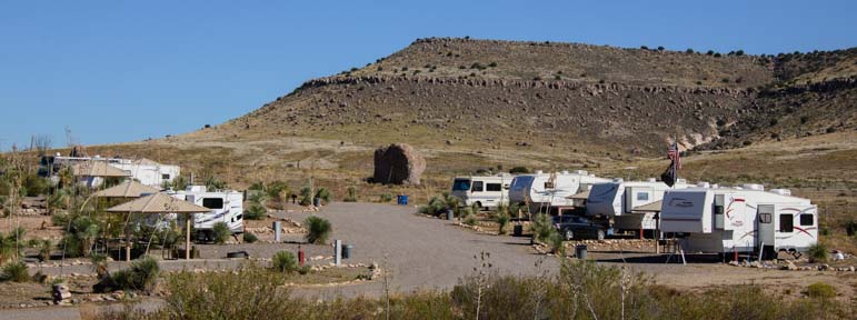
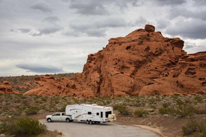
Suddenly, we saw a sign for the Redstone Picnic Area. We needed to take a break and get a little lunch, so we pulled in.

RV parking Redstone Picnic Area Lake Mead Nevada-min

Redstone Picnic Area – A fun RV pit stop!

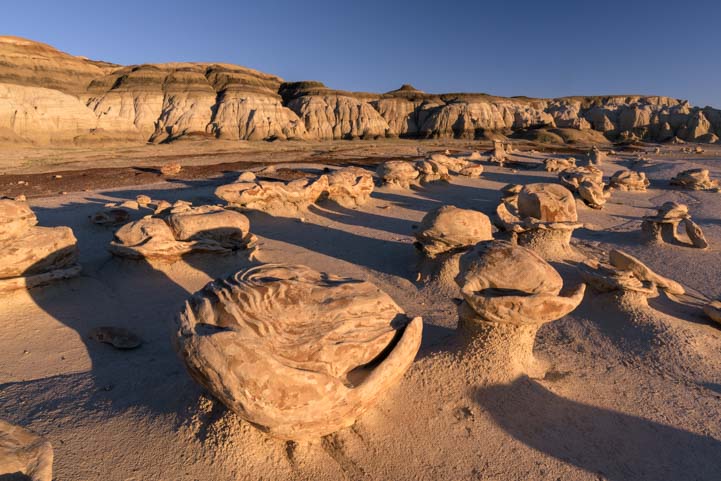
What a wonderful surprise this little jewel was! It’s like a little mini taste of Valley of Fire! There were pretty picnic ramadas scattered about the edges of the parking lot.

Redstone Trail picnic area Lake Mead Nevada RV trip-min

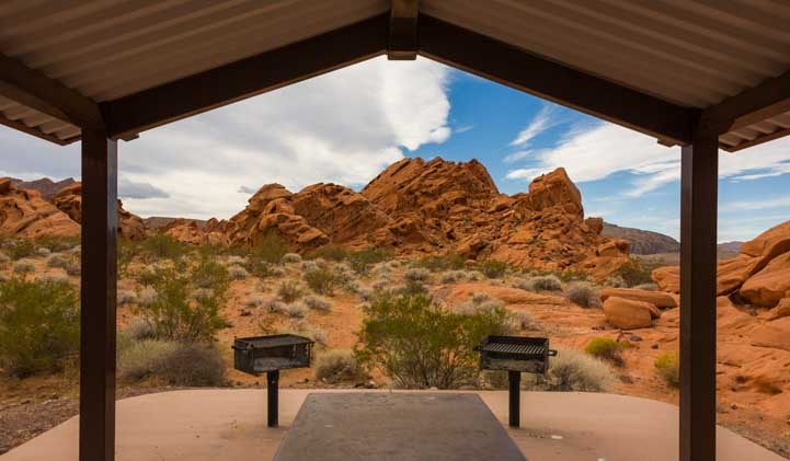
Picnic ramadas with grills!

Redstone Picnic Area Lake Mead Nevada RV trip-min

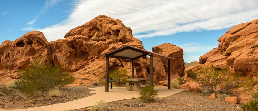
A nice place to take a breather from driving.

Never mind lunch, we had photos to take!

We jumped out of our truck and began snapping away. The red rock formations were so cool we both even took photos of the rocks framing the vault toilets. It’s gotta be a pretty spot when two photographers both feel inspired to take pics of a vault toilet building!!

Redstone Picnic Area Lake Mead Nevada vault toilets-min

We were loving the scenery so much we both took pics of the vault toilet building!

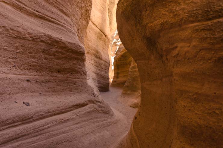
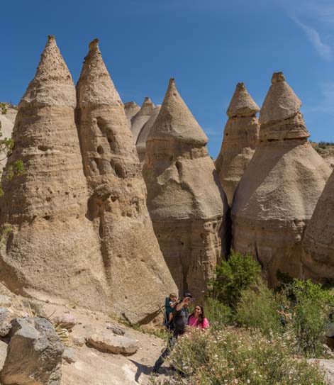
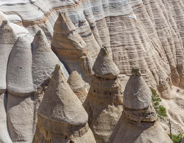
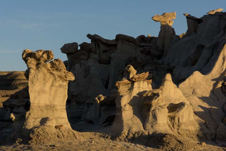
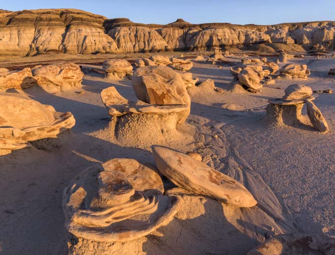
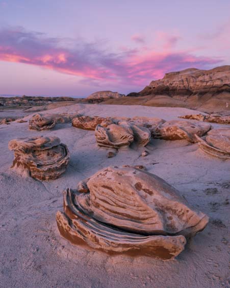
The Redstone Picnic Area has a short hiking trail that leaves the picnic tables behind and ventures out into the red rocks on a lovely loop around a huge red rock mound. I headed out on the trail for pics there while Mark moved in close to the red rock hill and got some great shots of the formations.

Arches on Redstone Trail picnic area Lake Mead Nevada RV trip-min

Arches…

Window view Redstone Trail Lake Mead Nevada RV trip-min

Views through windows…
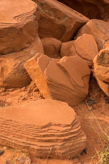
Red rocks at Redstone Picnic Area on a Lake Mead Nevada RV trip-min

Tumbled slabs…

Hiking at Redstone Trail on Lake Mead Nevada RV trip-min

The weather was overcast, but what fun we had scrambling around on the rocks.

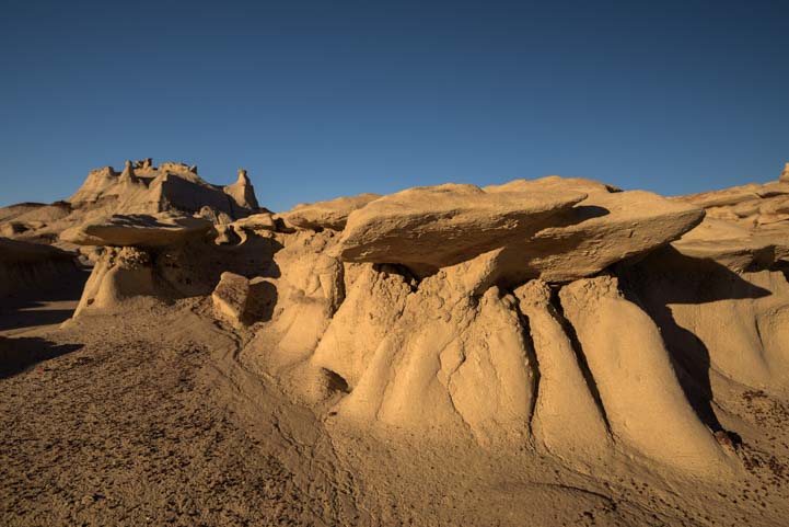
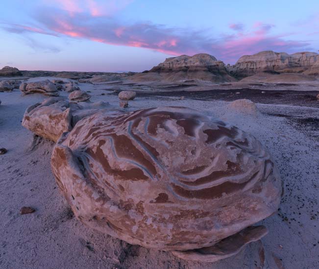
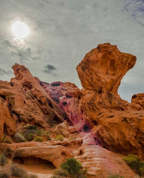
One of the things that always baffles me about the big rock and mountain formations in the west is the various “uplifts” that have occurred where wide flat expanses of rock have been upended by natural forces long ago.
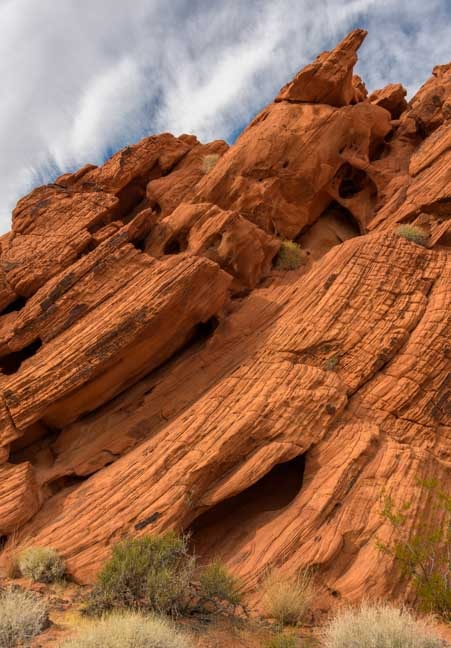
Uplift in red rocks at Redstone Trail on Lake Mead Nevada RV trip-min

An “uplift” !!

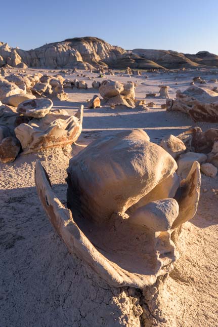
We also loved the various hollows and rounded alcoves and windows we found in the rocks.

Holes in rocks at Nevada Redstone Trail Lake Mead RV trip-min

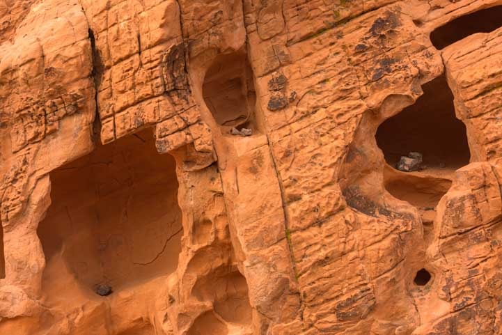
Natures built-in shelves.

Rock formations on Redstone Trail Lake Mead Nevada-min

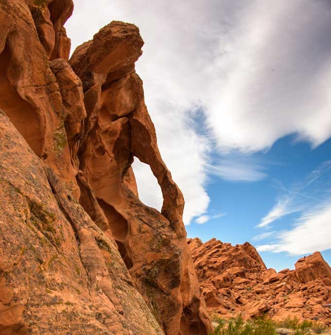
Window to the heavens.

Red rock formations Redstone Trail picnic area Nevada Lake Mead RV trip-min

.

A car or two pulled up during our stay but they moved right along after using the facilities. We were having so much fun crawling around on these beautiful red rocks. We didn’t want to rush our visit!

Huge red rock formations Redstone Trail Lake Mead Nevada RV trip-min

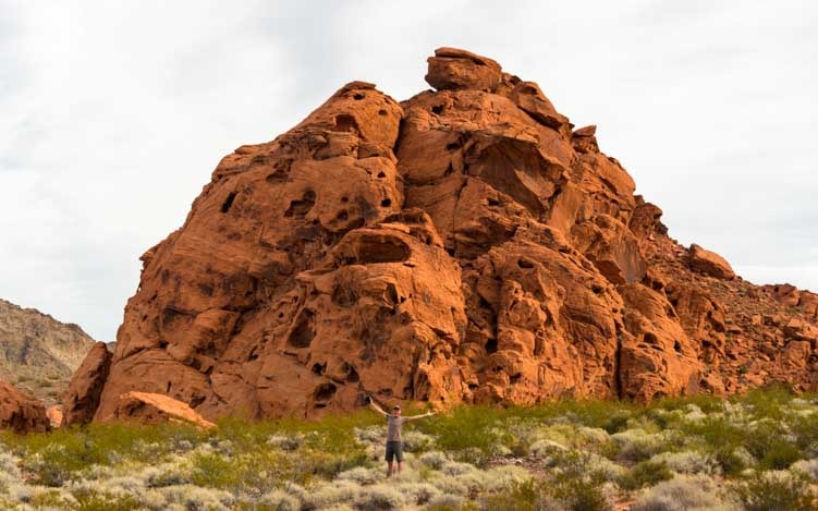
Big rocks, small guy!!

The hiking trail revealed some wonderful views on the far side.

Views on Redstone Trail picnic area Lake Mead RV trip-min

As the hiking trail rounded a bend, we could see far off into the distance.

And the gods painted the skies with fantastic patterns of sun and clouds just for our photos.

Redstone Trail picnic area Lake Mead RV trip-min

The sun played hide-and-seek and cast cool colors across the lens.

Redstone Trail picnic area Lake Mead RV trip-min

The clouds lined up for a photo op.

When we finally got back to our trailer, we got out our lunch goodies and sat down to yummy sandwiches.

Fifth wheel RV trip Redstone Trailhead Lake Mead Nevada-min

What a nice break this was!

Back out on the road we saw more wide open expanses and lovely views.

Scenic RV driving on by Lake Mead Nevada-min

The Lake Mead scenic drive continues.

The colors in the distant rocks and hills were wonderful earth tones — real earth tones — that reminded us of our trip to Death Valley years ago.

Colorful hills Lake Mead Nevada RV scenic drive-min

Reminiscent of Death Valley, California.

Rock formations on Lake Mead Nevada Scenic Drive by RV-min

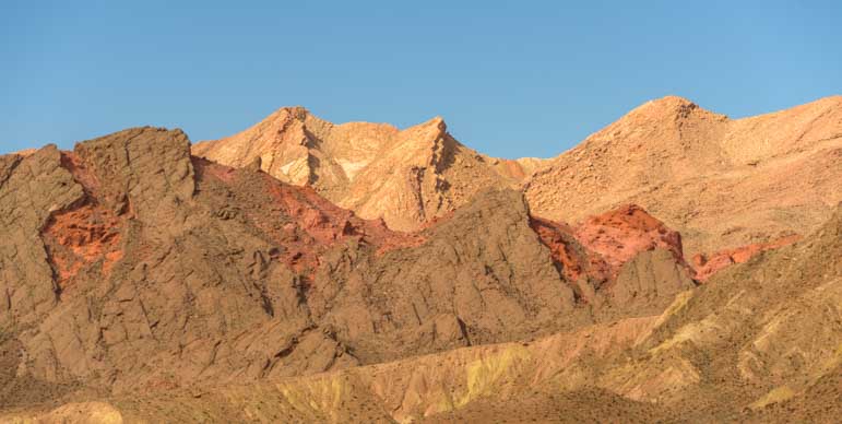
The brown crus peels off to reveal crimson rocks underneath.

At times we saw pockets of red rocks poking through.

Scenic RV driving on by Lake Mead Nevada-min

Vibrant red rocks add a splash of color to the landscape.

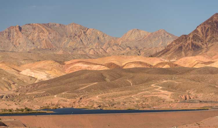
And then we finally arrived at the shores of Lake Mead. We stopped at a big parking area and wandered out to the edge of the overlook. Beautiful!

Lake Mead RV trip in Nevada-min

Lake Mead.

Lake Mead Nevada RV trip-min

From red rocks to lake views – what a drive!

If you are headed south on I-15 with your RV to get to Arizona and other parts of the southwest for the winter, or if you plan to take your RV back up north via that route in the spring, plan a detour around Las Vegas and check out this lovely scenic drive on the back side of Lake Mead!

Subscribe

Never miss a post — it’s free!

More info about this Lake Mead Scenic Drive:

Other blog posts from nearby Northwestern Arizona:

A few posts from Nevada too!

Our most recent posts:

More of our Latest Posts are in the MENU.   New to this site? Visit RVers Start Here to find where we keep all the good stuff. Also check out our COOL NEW GEAR STORE!! *** CLICK HERE *** to see it!

<-Previous || Next->

Tent Rocks National Monument (Kasha-Katuwe) – Hiking Slots & Spires!

May 2017 – While casting about for beautiful places to visit in New Mexico, I came across some images from Kasha-Katuwe Tent Rocks National Monument near Santa Fe. Unusual looking, perfectly conical rock peaks stood side by side against the sky. We just had to go check it out!

Kasha-Katuwe Tent Rocks National Monument New Mexico

A photo op with a “tent rock” (but this one isn’t real, lol!) .

Kasha-Katuwe Tent Rocks National Monument is a small park between Albuquerque and Santa Fe, New Mexico. It was a 230 mile drive to take our RV there from Aztec Ruins National Monument.

Spires Tent Rocks National Monument New Mexico

The beginning of the hike.

This is an extremely popular National Monument with loads of visitors coming out on weekends from nearby Santa Fe to hike the fun trail that goes through a slot canyon and emerges on a plateau with a great view. So, we were told that arriving at the tiny parking area before 9:00 am during the peak seasons of spring and fall is a really good idea or they won’t let you in!

Beginning Slot Canyon Tent Rocks National Monument New Mexico

The beginning of the slot canyon.

The hike is an out-and-back trail that starts easily enough by wandering in and around the bases of many unusual and towering rock peaks. But it is the slot canyon that is the most fun!

Slot Canyon Tent Rocks National Monument New Mexico

.

Slot canyons can look a little claustrophobia inducing in photos where hikers are slithering between towering rock walls.

Hiking Slot Canyon Tent Rocks National Monument New Mexico

.

But they are loads of fun, and you don’t feel particularly confined because the walls often spread apart as they rise up on either side, or they open up completely, and there’s a clear view of the sky up above.

Hiking Kasha-Katuwe Tent Rocks National Monument slot canyon

.

Sharing a narrow slot canyon with crowds of weekend hikers can be a crazy experience. Lots of families were out on the trail with us that beautiful May morning, even though we had started early. It was Mother’s Day weekend, and it seemed that everyone had decided to take Mom out for a hike to celebrate!

Crowded Slot Canyon Tent Rocks National Monument New Mexico

.

In some places the slot canyon got really skinny and it was one-foot-in-front-of-the-other type of hiking. But in other places it widened a little and we made our way between large rocks that were strewn in the trail.

Slot Canyon Hike Tent Rocks National Monument New Mexico RV trip

.

The undulating walls of the slot canyon made beautiful shapes.

Slot canyon Kasha-Katuwe Tent Rocks National Monument New Mexico

.

Once we got through the slot, the hike started to head dramatically uphill. Family after family came down past us, and all of them said the view up top was well worth the climb.

Busy hiking trail Tent Rocks National Monument New Mexico

.

As we ascended the trail, the “tent rocks” filled the view alongside us.

Tent Rocks Selfie Tent Rocks National Monument New Mexico

.

The trail was a bit of a scramble here and there, and as we got higher the tent rocks got a little lower.

Spires at Tent Rocks National Monument New Mexico

.

Finally we were near the top of the trail looking down at the unique conically shaped tent rocks.

Overlook Tent Rocks National Monument New Mexico

.

I don’t recall seeing a collection of stone cones like this before. What cool rock formations these are!

Closeup Tent Rocks National Monument New Mexico

.

The trail goes out on a long “peninsula” that offers a view back towards the tents.

View from the top Tent Rocks National Monument New Mexico

.

It was a perfect place to grab a quick selfie.

Selfie at Tent Rocks National Monument New Mexico

.

Spring was busy springing all around us. We saw Indian paintbrush flowers at our feet and lots of cacti had big vibrant flowers on display.

Indian Paintbrush flowers

.

Cactus flower

.

Cactus Flower

.

Some folks came prepared to enjoy the view for a while. Tucked behind one tree we saw a fellow uncorking a bottle of wine, and moments later his wife — the Mom and guest of honor — was sipping a glass of wine in the shade, enjoying the spectacular surroundings!

A picnic and wine at Tent Rocks National Monument New Mexico

.

Heading back down the way we came, the tent rocks slowly began to rise up around us.

The Tents at Tent Rocks National Monument New Mexico

.

Mark got a kick out of playing Atlas under a huge tree that had fallen across the trail, pretending to hold it up for folks that passed by.

Holding up a log at Tent Rocks National Monument New Mexico

.

And then we were back in the very cool slot.

Skinny slot canyon hike Tent Rocks National Monument New Mexico

.

By now it was midday and the trail was getting very crowded. Logjams formed in the trail as people took turns traversing the skinniest parts. It made me think of the traffic jams that were going on up on Mt. Everest at about the same time as hikers from around the world converged on the mountain in valiant efforts to make it to the summit.

Crowds on slot canyon hike Tent Rocks National Monument New Mexico

.

But if we hung back and waited for the crowds to pass, we were still able to find quiet times where we had certain curves in this beautiful slot canyon all to ourselves.

Hike the slot canyon at Tent Rocks National Monument New Mexico

.

Hike Kasha-Katuwe Tent Rocks National Monument slot canyon

.

Hiking the slot canyon Tent Rocks National Monument New Mexico

.

Near the end of the trail we passed the most fabulous ponderosa pine that was perched high above its very cool exposed roots.

Ponderosa Pine tree and roots in kasha-Katuwe Tent Rocks National Monument New Mexico

.

The next day we returned to do the other hike that forks off the Tent Rocks trail and goes to a cave. This was a short and easy hike, although the cave was surprisingly small and not nearly as exciting as the tent rocks and slot canyon!

The Cave Kasha-Katuwe Tent Rocks National Monument New Mexico

The Cave.

The tent rocks, however, were very cool and well worth seeing. Just be sure to get there early because the tiny parking lot fills up fast. Also, only the shortest truck campers, Class C’s and vans fit in the lot.

Nearby Cochiti Campground is a nice place to stay.

Fifth wheel trailer RV at sunset

Sunset at Cochiti Campground.

Subscribe
Never miss a post — it’s free!

More info about Tent Rocks National Monument:

Other slot canyons we’ve hiked:

Other Stories from our RV Travels in New Mexico

Our most recent posts:

More of our Latest Posts are in the MENU.
New to this site? Visit RVers Start Here to find where we keep all the good stuff!!

<-Previous || Next->

Eggs & Aliens in Bisti/De-Na-Zin Wilderness (Bisti Badlands)

May 2017 – There’s a wonderful natural treasure to be found in northwestern New Mexico at the Bisti Badlands — or Bisti/De-Na-Zin Wilderness — just 40 miles south of Farmington.

Bisti De-Na-Zin Wilderness New Mexico Photographing the Eggs

Hanging out with the alien eggs at Bisti/De-Na-Zin Wilderness in New Mexico

We had a very magical experience in this exotic location five years ago and we wanted to get back once again.

Exotic Landscapes Bisti De-Na-Zin Wilderness Bisti Badlands New Mexico

There are all kinds of hoodoos in the Bisti Badlands

The Bisti/De-Na-Zin Wilderness is a huge area filled with crazy rock formations that resemble everything from spacecraft to furniture to alien eggs. Because it is a wilderness area, there are no trails and no vehicles are allowed either. The only way to see it is to walk on in and start exploring.

The hoodoos and colorful mounds make for a great day of fun just getting lost in a maze of crazy shapes, and on our last visit we roamed all over the place climbing up and over red and black and orange striped conical hills that easily stood 50 to 100 feet high.

Bisti-De-Na-Zin Wilderness Bisti Badlands New Mexico

There are no hiking trails in Bisti Badlands, but walking in any direction takes you to cool rocks!

But the “prize” in Bisti Badlands, if there can be such a thing, is the tiny group of stones that look like alien creatures emerging from their cracked egg shells.

Cracked eggs Bisti De-Na-Zin Wilderness New Mexico

In one corner of the Bisti Wilderness there is a collection of rocks that look like alien eggs or pods.

Alien eggs Bisti De-Na-Zin Wilderness New Mexico

.

Cracked egg Bisti De-Na-Zin Wilderness New Mexico

.

This is a favorite area for photographers, and we headed out in the late afternoon as the shadows were getting long.

Alien egg Bisti De-Na-Zin Wilderness New Mexico

.

Some of the rocks look very much like eggs sitting on a dish or embryonic alien life forms emerging from the shell.

Eggs Bisti De-Na-Zin Wilderness New Mexico

.

Each one is a little different, and some look as though they might come to life.

Eggs on pedestals Bisti De-Na-Zin Wilderness New Mexico

A creature from afar?

Alien eggs Bisti De-Na-Zin Wilderness New Mexico

.

As we wandered around the perimeter of these fantastic rock formations and crouched down to see them up close, I suddenly heard Mark yell “Help!”

I turned around and saw his hand reaching out… he’d been swallowed up by an alien egg!

Human eating alien egg Bisti De-Na-Zin Wilderness New Mexico

Oh no!!

Not really, of course, but these little guys were very engaging and we were having lots of fun getting photos of them and playing with effects.

Eggs alien egg factory Bisti Badlands De-Na-Zin Wilderness

.

Sometimes we couldn’t help but get in the photo in one way or another, even if it was just a shadow of ourselves.

Photography at the Eggs Bisti De-Na-Zin Wilderness New Mexico

With such long shadows sometimes we had to incorporate our own shadows!

Hoodoos Bisti De-Na-Zin Wilderness New Mexico

.

As the hours went by, one by one, each egg lost the sun’s golden glow. Then the setting sun threw some pretty colors across the sky.

Hoodoos Bisti De-Na-Zin Wilderness New Mexico

.

One of the things I love most about these alien egg rocks is that each one is decorated with a different pattern on its surface.

Some have a wonderful pattern that seems very deliberate, as if carved by a divine hand.

Exotic egg Bisti De-Na-Zin Wilderness New Mexico

Each egg was decorated with a unique pattern.

Some are very bold, with definite lines and carvings.

Alien shellback Bisti De-Na-Zin Wilderness New Mexico

.

Others have finer lines and have started to fade in places.

Decorated egg Bisti De-Na-Zin Wilderness New Mexico

.

And some don’t have any decorations at all.

Egg in shell Bisti De-Na-Zin Wilderness New Mexico

.

Decorations or no, you just can’t beat seeing one of these crazy egg rocks set off by a pink sunset.

Eggs at sunset Bisti-De-Na-Zin Wilderness Bisti Badlands New Mexico

.

And then, with a flash from the west, the sun was gone.

Sunset Bisti Badlands De-Na-Zin Wilderness

.

We decided to stick around to see what this other-worldly place looked like at night.

We’d brought our big flashlight with us which is like a car headlight (review here). We put it on its lowest setting and began playing with it doing “light painting” on the rocks. Cool!

We also had two smaller 1000 lumen pocket flashlights (review here), and we experimented with using them for light painting as well. The smaller, dimmer lights produced a wonderful effect.

721 Cracked eggs at night Bisti De-Na-Zin Wilderness New Mexico

We did a little “light painting” on the eggs with a flashlight as it got dark.

A few stars began to twinkle in the rich light of dusk. The moon was rising and looked like a huge street light above us. Mark was using his favorite wide angle lens and it made a fabulous starburst out of the moon!

Full moon starburst Bisti-De-Na-Zin Wilderness Bisti Badlands New Mexico

The nearly full moon created a starburst in the sky at dusk.

Back at the trailer when we were going through our photos, Mark emailed this cool shot to a friend who’s a video arts and Photoshop expert. Suddenly he got an email back that looked a little spooky!

Full moon starburst Bisti-De-Na-Zin Wilderness Bisti Badlands New Mexico with UFO

What’s that flying over the cliffs?

As a gag, he emailed the revised photo to another good friend who is also a photographer and Photoshop expert, and suddenly it came back looking even spookier!

UFO Full moon starburst Bisti-De-Na-Zin Wilderness Bisti Badlands New Mexico

OMG – They’re shining their spotlight on our rig!

But before we could play with our photos in the rig, we had to get back out of Bisti Badlands in the dark.

I was glad the moon was so bright. Like our old days of sailing on our boat when we made long ocean passages at night, the moon was like a very dear friend in the sky. The eggs around us were easy to see, and it even cast shadows on the ground.

Stars at cracked eggs Bisti Badlands De-Na-Zin Wilderness New Mexico

Eggs by the light of the moon.

Even with the moon so bright, more and more stars began to appear in the sky above us.

Stars at night Bisti De-Na-Zin Wilderness New Mexico

As we hiked out we saw more and more stars.

Hiking out in the dark was quite a thrill. We heard some coyotes very close by and were hoping to catch a glimpse of them, but they must have caught our scent and heard our footsteps because they soon headed off into the night.

Stars over hoodoos Bisti De-Na-Zin Wilderness New Mexico

Stars over the hoodoos.

Every so often we could see the lights of a power plant in the distance, keeping us more or less on track! We ended up scaling a few more deep washes on the way out than on the way in, but we made it out just fine!

Some notes and a word of caution for folks heading to Bisti/De-Na-Zin Wilderness with RVs:

The Bisti/De-Na-Zin Wilderness is managed by the Bureau of Land Management (BLM) and is a very special place that is well worth a detour to visit.

RVs are allowed to park overnight in the fenced off parking area which can hold a few truck campers or perhaps 3-4 larger RVs. The “RV” end of the parking lot can get very muddy when it rains and the ruts from RVs that had been there during recent rains were quite deep.

This parking area is located about 3 miles down a dirt road off of Route 371. When we went to Bisti Badlands in late September of 2012, the 3 mile dirt road was well graded and it wasn’t difficult to drive on with our fifth wheel trailer.

Now, however, it appears that the road has not been graded in a very long time, and it is absolutely terrible. We drove at 3-9 mph the entire way in both directions, no joke. Not only was everything in our rig badly shaken up but we discovered the locking nut on one of the bolts that goes through the equalizer in our fifth wheel suspension actually fell off. Without a locking nut, the bolt had worked itself almost all the way out during our drive in. Luckily, Mark was able to fix this right there in the dirt parking lot. More on that coming soon!

More importantly, it seems that Bisti Badlands has been “discovered.”

In 2012 we were the only RV there for one night and we had just one companion RV another night. This year the parking area was quite busy every night with cars, vans, truck campers and short Class C’s crammed in, and lots of people came in cars to hike for the day as well.

In 2012 there were no footprints beyond the gate into the wilderness area, and this year there were footprints everywhere, especially leading to the eggs, and there were lots of people out hiking. In 2012 there were a few boondocking areas down the road, but now there are markers at those spots saying “No Vehicles.”

As we were packing to leave Bisti Badlands on a Saturday morning, four cars arrived and joined the RVs that had stayed overnight. During the 45 minutes it took us to drive the dirt road out to the highway, 12 more cars and trucks passed us on their way in. I have no idea if or how all those vehicles could fit in the parking lot!

So…. if you own a bigger RV, it might be wise to leave it in Farmington and make a day trip to Bisti Badlands in the tow vehicle or toad. Mid-week will be quieter than weekends, especially during the peak seasons of spring and fall.

Subscribe
Never miss a post — it’s free!

More info about Bisti/De-Na-Zin Wilderness (Bisti Badlands):

The website for the BLM is undergoing many changes and doesn’t have information about Bisti/De-Na-Zin Wilderness at the moment. We describe how we found the eggs on our previous visit at this link.

Location of Bisti/De-Na-Zin Wilderness Parking Area – Interactive Google Maps

If you go into the Bisti Wilderness with a friend or spouse, it’s a good idea to stick close together or take a set of two-way radios. We used both our radios and a hand-held compass. A hand-held GPS can be a helpful tool too (although we just used our compass). We also used all three of our Lumintop flashlights (reviews HERE (searchlight) and HERE (pocket flashlights).

Other blog posts from New Mexico:

Night hikes and starry skies:

Our most recent posts:

More of our Latest Posts are in the MENU.
New to this site? Visit RVers Start Here to find where we keep all the good stuff!!

<-Previous || Next->

Petrified Forest National Park RV Trip – Magic in Jasper Forest

April 2017 – One of the highlights on Route 66 is the Petrified Forest National Park where the enormous trunks of 200 million year old trees have turned to stone.

Photography at Petrified Forest National Park Arizona Jasper Forest

The solid stone tree stumps at Petrified Forest National Park are truly impressive!

We have been to Petrified Forest National Park twice before, but it was on this trip that we finally found the true magic there.

Stumps Petrified Forest National Park Arizona Jasper Forest

Those tree stumps are solid rock, through and through!

We knew that the best way to see Petrified Forest National Park, like all the National Parks, is to get out on the hiking trails away from the crowds.

Jasper Forest petrified logs Petrified Forest National Park Arizona

We loved seeing how the logs split over millenia, due to the pressures of moisture and ice,
and revealing the tree rings — still perfectly intact — inside.

But it wasn’t until this visit that we discovered which hiking trails are the most stunning.

Logs Petrified Forest National Park Arizona Jasper Forest

Was the woodsman just here with his ax?

On our first foray into the Park on this trip we explored the area called Crystal Forest.

Logs Petrified Forest National Park Crystal Forest

The logs were scattered everywhere. But there wasn’t a living tree to be seen anywhere!

In every direction we saw the enormous trunks of trees that had been growing millions of years ago.

These trees had toppled over during torrential rains millenia ago, and had floated downstream only to end up in a deep and muddy logjam where they slowly and very gradually crystallized.

Over time, the pressure of moisture and ice within the logs broke them into segments.

Out on the vast treeless plain, we saw countless tree trunks that looked like a lumberjack had just sliced them up with a chainsaw in preparation for splitting them into firewood!

Petrified log Petrified Forest National Park Crystal Forest

We saw many 50+ foot long logs lying on the grass and split into sections.

Here and there, the stump of a tree trunk stuck up from the ground and looked for all the world like the tree had just been felled.

Wildflowers with petrified wood tree stump Petrified Forest National Park Arizona Jasper Forest

A rock and a wildflower.

All the tree rings were perfectly visible in a rainbow of crystalline colors.

Tree rings Petrified Forest National Park Jasper Forest

Brilliantly colored minerals have crystallized the tree rings in this ancient tree.

The logs lay scattered all over the place, and in between were beautiful shards of petrified wood.

Colorful agate Petrified Forest National Park Jasper Forest

There were exquisite shards of rock EVERYWHERE as far as the eye could see in all directions.


Some logs had been split so the tree rings were visible while others had been severed lengthwise showing vertical striations from the interior of the log.

Colorful agate Petrified Forest National Park Jasper Forest-2

.

In one area the shards that surrounded the logs look like woodchips. It was as if the lumberjack had just laid down his ax! These pale wood chips were very thin, just like ordinary wood chips, but these slivers of rock tinkled like a bell when dropped on each other!

Petrified wood chips at Petrified Forest National Park Jasper Forest

The light colored “wood chips” on the ground were brittle rock shards that sounded like bells
when they fell on each other.

We had wandered out at the “golden hour” about an hour before sunset, and as the sun sank below the horizon we were blessed with a beautiful sunset over these exotic rocks.

Sunset at Jasper Forest Petrified Forest National Park Arizona

Sunset in Petrified Forest National Park.

Even better than Crystal Forest, however, is Jasper Forest which is just a little further north. The overlook takes in a sweeping view.

Jasper Forest Overlook Petrified Forest National Park Arizon

Jasper Forest overlook has an incredible view — see the logs below? — and the trail to the plain below took us down among thousands of logs.

In the distance, far below the Jasper Forest overlook, boulders and petrified logs intermingled.

Overlook at Jasper Forest Petrified Forest National Park Arizona

Huge waves of eroded rock formations were littered with tumbled boulders and petrified logs.

When we stopped at the Visitors Center to find out where the best collections of petrified wood were in the Park, the ranger took out a large 3-ring binder labeled “Off The Beaten Path Trails.” He took out the trail directions, complete with photos, for a few trails and handed them to us. One set was for Jasper Forest.

Sitting on petrified logs Petrified Forest National Park Arizona Jasper Forest

Down among the petrified logs at Jasper Forest.

The trail directions were a bit confusing, but they are actually very easy:

  • Go to the north end of the Jasper Overlook parking lot and look for a narrow trail heading north from the last parking space in the lot.
  • Follow this trail north and then west onto the wide plain that stretches out below the Jasper Forest overlook.
Petrified logs Petrified Forest National Park Arizona Jasper Forest

Two faces from the same log reveal gorgeous tree rings.

From there you can go in any direction you want, and we quickly ran off in opposite directions!

Log with a knot Petrified Forest National Park Arizona Jasper Forest

The “bark” on this 200 million year old log even had a knot in it.

We were there in the harsh light of noon, so even though the rock logs were mind boggling, we knew they would be even more beautiful in the rich light of late afternoon.

Petrified logs Petrified Forest National Park Arizona Jasper Forest

.

Petrified wood logs Petrified Forest National Park Arizona Jasper Forest

.

So, we returned a little later with our cameras, and suddenly the logs came alive in vivid shades.

Petrified tree stump Petrified Forest National Park Arizona Jasper Forest

At the “golden hour” an hour before sunset,
all the logs began to glow.

The skies were darkly overcast but the sun snuck through underneath and cast a brilliant light on all the stone tree logs.

Storm clouds Petrified Forest National Park Arizona

Storm clouds darkened the skies while the sun peeked through.

Golden light at Jasper Forest Petrified Forest National Park Arizona

Looking at the tree root ends of the logs — in rich light.

As the sun sank towards the horizon, we were in awe of the beauty around us. We were also frantically running around trying to capture it as best we could while the sun teased us mercilessly!

At one moment the sun would pierce through the clouds and light everything up in bright orange and yellow, and at the next moment it would disappear all together behind the clouds!

Petrified logs at Jasper Forest Petrified Forest National Park Arizona

.

The clouds were flying across the sky, making an ideal opportunity to use long shutter speeds to make them blur dramatically just as the sun set in a starburst.

Sunset at Jasper Forest Petrified Forest National Park Arizona

Drama in the sky above an ancient world of stones.

Wild skies at Jasper Forest Petrified Forest National Park Arizona

.

Dramatic clouds at Jasper Forest Petrified Forest National Park Arizona 2

.

Petrified Forest National Park is a great place to go with an RV, and it is surrounded by many of the most spectacular natural wonders of America’s southwest.

RV motorhome in Petrified Forest National Park Crystal Forest

A motorhome passes the Crystal Forest turnoff.

Subscribe
Never miss a post — it’s free!

More info about Petrified Forest National Park:

Other blog posts from our travels in Northeastern Arizona:

National Parks and World Heritage Sites – by RV, sailboat, and airplane!

Our most recent posts:

More of our Latest Posts are in the MENU.
New to this site? Visit RVers Start Here to find where we keep all the good stuff!!

<-Previous || Next->

Bell Rock Pathway, Sedona AZ – Hiking & Biking the Red Rocks

February 2016 – We packed up our RV in Tucson, Arizona, when the daytimes highs began to creep over 90 degrees, and hightailed it back through Phoenix and on up to Sedona where the 4,000′ elevation makes the climate about 10 degrees cooler than down in the Sonoran Desert regions of the state.

We hadn’t been in the red rocks in over two years, and when we first caught sight of the towering red cliffs and rock formations that envelop the town of Sedona, we were almost breathless with excitement. We couldn’t wait to hit the trails, and one of the best places to immerse yourself in red rock scenery is right in the heart of it all on the Bell Rock Pathway.

Bell Rock Pathway Sedona Mountain Biking

Within a few moments of getting on the Bell Rock Pathway, hikers and bikers are immersed
in the best of Sedona’s red rock scenery

We were joined by special friends, and we set off on our mountain bikes.

Ready to ride bikes on Bell Rock Pathway Sedona AZ

Our friends Rich and Mark join us to ride the red rocks!

Bell Rock Pathway is one of the most popular hiking and biking trails in the area, and it is inundated with bus loads of tourists every day. But we were on the trail fairly early on a weekday morning, and there were just a few hikers here and there.

Hiking and biking Bell Rock Pathway Sedona Arizona

Bell Rock Pathway is shared by walkers, joggers and mountain bikers,
but there’s plenty of room for everyone.

The magic of the Bel Rock Pathway is that you don’t have to go very far to be totally wowed by the scenery. In fact, we always find we get swept up in the stunning scenery right in the parking lot, and many of the bus loads of tourists never make it past the asphalt!

Bell Rock Pathway Mountain biker and jogger Sedona AZ

What a place to go for a run — or a bike ride!

Bell Rock Pathway is beloved by walkers, joggers, and mountain bikers, and the path is wide and relatively smooth and extraordinarily scenic.

Jogger and biker Bell Rock Pathway Sedona Arizona

The views are great in every direction!

The Bell Rock Pathway parallels the main road, and there are three parking lots that give you access to the two ends as well as the middle of the trail. We started at the southern end, and the trail climbed steadily for about a mile. But the jaw-dropping vistas were worth every huff and puff as we went along.

Mountain bike Bell Rock Pathway Oak Creek Arizona

As soon as we got a little distance from the parking lot we had the trail to ourselves.

Bell Rock Pathway is a very easy mountain biking trail and is ideal for beginners. Yet there are just enough little challenges here and there to keep more advanced riders on their toes. The views become more and more spectacular with every pedal stroke.

Mountain bike Bell Rock Pathway Sedona Arizona

I couldn’t stop taking pics of Mark as he rode ahead of me!

After the first mile, the terrain goes up and down and sweeps around twists and turns qutie a bit. And then suddenly it opens up to this fantastic area of wide, flat rocks.

Bikers Bell Rock Pathway Sedona Arizona

After a mile or so the path opened onto wide flat rocks with outstanding views all around us.

Standing in the middle of this wide open area, there are eye-popping views every way you turn. It literally doesn’t matter which direction you look, you are surrounded by majestic, towering red rock formations.

Flat rocks MTB Bell Rock Pathway Arizona

These flat rocks are an ideal spot to take a breather and look around!

And then the trail takes off again, descending through wide turns.

Mountain bikers on Bell Rock Pathway Sedona Arizona

The middle portion of the trail sweeps through turns and rolls up and down small hills.

Bell Rock Pathway is a trunk route that has lots of little off-shoots, and all of those other trails are more difficult. We simply rode it to the end, about 3.5 miles from our strating point, and turned around to retrace our route.

Mountain biking Bell Rock Pathway Sedona Arizona

The Bell Rock Pathway is about 3.5 miles long one way.

The beauty of this hiking and biking trail is that the views on the way back are completely different than the views on the way out, and the lighting on the rock faces changes constantly.

Bell Rock Pathway Mountain Biking Sedona AZ

Weeeee! Bell Rock Pathway is easy and fun.

Riding behind Mark, I couldn’t stop clicking the camera, framing him inside of one magnificent view after another. Holding the camera up and riding one handed is a little dicey, though, and always makes for a rather exilharating ride!

Mountain Bikers Bell Rock Pathway Sedona Arizona

The return trip has all new views for us!

Mountain biker Bell Rock Pathway Sedona Arizona

Bell Rock Pathway is worth doing over and over again — it’s easy and it is stunning!

We enjoyed our bike ride on the Bell Rock Pathway so much that we came back to do it again a few days later.

Mountain bike Bell Rock Pathway Sedona Arizona

One very happy camper!

Mountain bike on Bell Rock Pathway Sedona AZ

We enjoyed riding our bikes on the Bell Rock Pathway, but most of the people out there were walking…

For RV travelers in search of a good way to get out into the Red Rocks without doing a strenuous hike or challenging bike ride, the Bell Rock Pathway is an ideal trail.

RV camping under the stars in Sedona Arizona

At the end of the day we all put our feet up under the stars…

Feeling a little rusty bike-wise? It might be time to get back on it again! Two years ago our 76 year old friend Marcel showed us that mountain biking is the Fountain of Youth (blog post here). Now 78, he’s still shredding the gnar out there, and all winter long he’s been mountain biking in Arizona!

More info and links for Sedona’s Bell Rock Pathway below.

Subscribe
Never miss a post — it’s free!

More info about the Bell Rock Pathway:

There are three trail head parking lots, and each one requires a parking pass, either the Red Rock pass or a Federal Interagency Pass (the old “National Park Pass” or Senior Pass). And be sure to get there early, especially on a beautiful sunny weekend.

Other posts from our RV travels featuring hikes and bike rides in red rock country:

Fun things to see and do while RVing in Sedona

Our most recent posts:

More of our Latest Posts are in the MENU above.

<-Previous || Next->

City of Rocks State Park, NM – RV Camping in the Hoodoos!

November 2015 – Scooting across New Mexico, we left the display of aging missiles at White Sands Missile Range Park and made our way to a place on the map that looked too fun to miss — the City of Rocks. As we traveled, stunning sunrises and sunsets continued to punctuate the start and end of everyday.

New Mexico Sunset CIty of Rocks

A wonderful New Mexico sunset!

The City of Rocks is a huge collection of massive boulders clustered together in a vast open plain. For miles, all we had seen was wide vistas of nothing, barely a bush and not even a tree. Then we suddenly saw “the city” ahead.

City of Rocks New Mexico

The City of Rocks!

New Mexico has turned this “urban” landscape into a wonderful state park that is essentially a huge campground with hiking trails scattered through and around it.

RV camping City of Rocks New Mexico

New Mexico’s City of Rocks is a little camping paradise.

At the entrance to the park there is an area with electric and water RV hookups.

RV hookup campsites City of Rocks Campground New Mexico

There are hookups if you want them.

The rest of the “city” is filled with charming campsites that snuggle up against the rocks.

RV camped at City of Rocks Campground New Mexico

You can be off on your own communing with the hoodoos!

RV camping at City of Rocks New Mexico

What a neat campsite!

We were enchanted. What a fun place to camp!

Motorhome at City of Rocks Campground New Mexico

.

We hopped on our bikes and checked out the trail that encircles the whole area. This is a very pleasant trail for walking (it’s just a few miles long) or for biking.

Moutain biking City of Rocks New Mexico

There’s a short trail for hiking or biking.

We had fun taking our bikes around the campground loops.

Mountain bike ride City of Rocks New Mexico

A very fun place for a bike ride!

The trail also climbs a steep hill at one point, and we had a blast bombing down the road.

Bicycling City of Rocks New Mexico

Barreling downhill towards the city.

Early one morning, we spotted a hawk that was surprisingly calm and didn’t seem to mind us too much.

Bicycling City of Rocks New Mexico

A hawk keeps an eye on me but doesn’t get spooked.

Each campsite is unique, and they come in various sizes and shapes.

Camping in an RV at City of Rocks New Mexico

I just love a retro trailer. This one is actually almost brand new!

Some campsites are fairly level and some are very unlevel, but each one is charming.

Motorhome camping at City of Rocks New Mexico

.

On the Pegasus North Loop you can get away from it all and be quite far away from the “hubub” of “the city.” However, if you want to stay more than one night on that loop, you have to reserve in advance.

RV with solar panels City of Rocks New Mexico campground

On the Pegasus Loop you need to reserve ahead or just stay one night.

We loved this little spot, and highly recommend it to anyone planning a visit to New Mexico. For RV travelers that are headed east-west on I-10, the nice thing is it’s not too far from the freeway — just under 30 miles.

Motorhome RV camping City of Rocks New Mexico campground

A beautiful pink-and-blue sky… I love those skies in the early evening in the western deserts!

The cost when we stayed at City of Rocks was $10/night for dry camping and $18/night for electric and water hookups. The cool thing about New Mexico is that you can purchase an annual State Parks camping permit (currently $225 for non-New Mexico residents and $180 for the lucky in-state crowd) that gives you huge discounts on overnight camping. If you have one of these nifty camping permits, the dry camping sites are free and the electric/water sites are $4/night. More info below…

Subscribe
Never miss a post — it’s free!

More info about City of Rocks:

More great RV campgrounds:

Our most recent posts:

More of our Latest Posts are in the top MENU above.

<-Previous || Next->

Acadia National Park – Alluring Beauty on the Maine Coast

June 2015 – Maine’s Mt. Desert Island (pronounced “dessert” despite the spelling!) is home to several small harbor-front towns as well as lovely Acadia National Park. We made a beeline for the trendy and chic seaside town of Bar Harbor as soon as we got there.

Two old cannons face the water in the middle of town, aimed almost directly at a pretty schooner in the harbor. Mark decided to have a look down the barrel of one!

Cannons and schooner Bar Harbor Maine

Boom!

It was early in the morning, well before the crowds of tourists began to fill the streets, and we enjoyed the quiet and peaceful feeling of the place. This is an upscale town loaded with high end galleries and boutique shops, and it was nice to walk the main street and window shop completely by ourselves for a while.

Boutique shops Bar Harbor Maine

Shops on the main drag in Bar Harbor

Another wonderful small waterfront town is Northeast Harbor (whose sister town, Southwest Harbor, lies across the bay). All of these towns made for fun excursions during our stay, and we spent many a happy hour walking along the docks and watching the boats in the harbor.

Boats in Northeast Harbor Maine

Scenic Northeast Harbor

A lot of Maine harbors are geered primarily towards the lobster boat fleet, but Northeast Harbor is also home to many beautiful sailboats — and some unusual looking ones too!

Antique ketch Northeast Harbor Maine

Northeast Harbor has sleek fancy yachts and cute antiques too

Mt. Desert Island is shaped something like a lobster claw with a pair of wide pincers hanging down. Acadia National Park takes up most of the eastern lobe and much of the western lobe too. In the eastern portion — the main part of the park — there is a Loop Road that passes the major sights.

The eastern 2/3 of this road is one way, and in our excitement to see it all on our first day in Acadia, we blew right by the visitors center, missed some key signs and wound up at the far end of the loop road facing the wrong way, trying to figure out how to see the park. Oops!

Scenic drive Acadia National Park Maine

The drives around Mt. Desert Island are wonderful

We got ourselves sorted out the next day and, map in hand, drove the loop clockwise as you are supposed to! Stopping at some of the viewpoints, we were quickly swept up in the beauty of the craggy shorline.

Crashing surf Acadia National Park Maine

Crashing surf on Maine’s rugged coast.

There were wonderful, huge granite boulders, and some of them even held tidepools. I love these northeast tidepools. There are whole ecosystems of algae, seaweed, periwinkels and limpets living in them, and many are lined with an ultra soft and rich red velvet that is some kind of algae.

Tidepools in rocks Acadia National Park Maine

We found lots of pretty tidepools

Rocky coast Acadia National Park Maine

We LOVED the mix of pine trees and jagged granite boulders on the coast.

I wandered way off so I wouldn’t keep getting in Mark’s photos, and around the bend I saw a lobsterman busy hauling his traps. I took a bunch of photos of him and then noticed that he waved to me. I took my camera down from my face to wave back. When I raised it again, I saw through the telephoto lens that he hadn’t been waving — he’d been holding up a wriggling lobster for me!

Unfortunately, he dropped the lobster into his bucket before I realized what he was doing, and I missed the shot.

Darn! The one that got away…

The one that got away!

I didn’t realize he was showing off a lobster for me to photograph until too late!

One of the most popular attractions at Acadia National Park is Thunder Hole, an opening in the rocks where the waves crash in and out, sending up a huge spray of water. To see the biggest spray, you have to catch it as the tide is coming in. The tide was going out when we swung by, but it was still neat to hear the gurgles, gulps and belches booming between the rocks far below as the waves washed in and out.

Thunder Hole - cool sounds on an outgoing tide and huge splashes on an incoming tide

Thunder Hole – Booming sounds on an outgoing tide plus huge splashes on an incoming tide.

This shoreline is very alluring, and we had such fun scrambling over the rocks.

Rock crevice Acadia National Park Maine

I swear, these kinds of big boulders bring out the kid in me.

These are SO MUCH FUN to run around on!

What a coastline! If you don’t want to run and jump on the rocks, Thunder Hole has a solid railing…

Dramatic sky Acadia National Park Maine

A touch of drama in the sky.

Acadia National Park is a very popular place, and the park was very busy even though we had arrived ahead of the summer crowds (New England public schools were still in session because they’d had so many snow days during the endless winter blizzards). The roads are narrow and winding, and some crazy people like to bomb down them like they’re a racetrack.

One group of travelers, however, was enjoying every minute of slow driving on these roads — a Ford Model A club! They were so cute that none of the other drivers objected to their pace. Some 170+ Model A’s attended this rally, and everywhere we went we ran into little groups of them.

Seeing them out on the roads was lilke stepping back in time.

Antique Model A drives up Cadillac Mountain Acadia National Park Maine

A Ford Model A rally took us back in time.

This group was having a ball, and the weather was perfect for them, so they drove around with the tops down and their beautiful leather suitcases strapped on the back bumpers.

Happy driver of a Ford Model A

Those guys were having too much fun!

Enjoying a fabulous road trip!

Enjoying a fabulous road trip!

Ford Model A cars lined up

These guys were all over the park. What fun!

Another Acadia National Park favorite is to take a drive to the top of Cadillac Mountain, the highest point in the park. We zoomed up the mountain, watching the views grow ever larger around us. And who was waiting for us at the top? A bunch of those Model A’s!!

Ford Model A parked on Cadillac Mountain Maine

View from the Top

The views were truly beautiful — you can see the many islands of Frenchman Bay in the distance — but we got the biggest kick out of watching these cute Model A’s drive down these wonderful roads. They had come to Acadia National Park from all over the country, most making the trip on their own four wheels. One club member even hailed from Australia, although he’d left his Model A at home.

Ford Model A car drives down Cadillac Mountain Acadia National Park Maine

What a classic image descending Cadillac mountain!

Two Ford Model A cars descend Cadillac Mountain Acadia National Park Maine

.

If you take your RV to Mt. Desert Island, unless it is fairly short in length and short in stature, you’ll be happiest leaving it behind as you tour the park. The scenic viewpoint parking is not RV friendly and there are bridges on the Loop Road as low as 11′ 8″. We enjoyed a fabulous stay at Narrows Too RV Resort, about 7 miles north of the north entrance to the park.

Subscribe
Never miss a post — it’s free!

Our most recent posts:

More of our Latest Posts are in the top MENU above.

For More Info:

Other blog posts from our RV travels in Downeast Maine

Here are some of our blog posts with similar themes!

<-Previous || Next->

Bryce Canyon, UT – Fairyland of Pink Turrets

Inspiration Point overlooking Bryce Ampitheater

Inspiration Point overlooking Bryce Ampitheater

Bryce Canyon Point

Bryce Canyon Point

Smiles everywhere at Bryce Canyon

Smiles everywhere

Stunning views at Bryce Canyon, Utah Stunning views at Bryce Canyon, Utah

Natural symmetry

Stunning views at Bryce Canyon, Utah

The regularity and precision of

these formations can be dizzying.

Trees cling to the rim at Bryce Canyon, Utah

Trees cling to the rim

Bryce Canyon Ampitheater

Bryce Ampitheater

Rim views, Bryce Canyon, Utah Beginning of Queen's Garden hike Bryce Canyon, Utah

Beginning of Queen's Garden hike

The spires give way to a smooth, orange and red moonscape at Bryce Canyon, Utah

The spires give way to a smooth, orange and red

moonscape

Bryce Canyon, Utah

Trees from another planet

Queen's Garden Bryce Canyon, Utah

End of the trail -- at Queen's

Garden

Nature's Wall Street at Bryce Canyon, Utah

Nature's Wall Street

Looking down from the top of the Wall Street switchbacks at Bryce Canyon, Utah

The top of the Wall Street switch backs

Bryce Canyon, Utah Bryce Lodge has many cute cabins for guests

Bryce Lodge has many cute cabins for guests

The Peek-a-boo hike at Bryce Canyon defies nature's laws and seems to ascend for the entire loop.

The Peek-a-boo hike defies nature's laws and seems

to ascend for the entire loop.

Serenity along the hiking trails at Bryce Canyon

Serenity

Spires and spikey trees surrounded us at Bryce Canyon, Utah

Spires and spikey trees surrounded

us

Peek-a-boo, the namesake of the Peek-a-boo trail at Bryce Canyon

Peek-a-boo

Seeming chess pieces at Bryce Canyon

At times it seemed as though we were wandering

among towering chess pieces.

Stunning view at Bryce Canyon, Utah

A promontory hangs into the canyon for an awe

inspiring view.  A good place to take a breather!

Tunnels and arches at Bryce Canyon, Utah

Little tunnels and hobbit doorways invite the hiker to

vast views on the other side.

Bryce Canyon National Park, Utah

July 20-August 20, 2008 - We had

arrived in the lower elevations of

Kanab, UT and visited Best

Friends Animal Sanctuary,

during a peak week of monsoon

activity.  Monsoons are a

southwest phenomenon that give

the desert's much needed

moisture and relief from the heat

in mid-summer.  I had learned

about them living in Arizona, but

had never known that they could

spread their salve as far north as

southern Utah and even over into

southern Colorado.  It is magic to

watch the sky cloud over promptly

at noon every day, and there is a

lusciousness to being drenched

by brief downpours every

afternoon.  These storms leave

the air crisp and clear, and they

keep the ferocious heat to a minimum.  Once the monsoons abated, we

found ourselves in an oven, baking by noon, and burnt to a crisp by

evening.  Full of energy at the break of day, we were lethargic sloths by

nightfall.  It was time to get back to the higher elevations.  We left Kanab

for Ruby's Inn, a settlement just outside of Bryce Canyon National Park at

7,500 feet.

Bryce Canyon

is a wonderland of pink and white

spires, laid out with amazing

symmetry.  The open bowl of

crystalline formations carved from

the surrounding flat plains

resembles an ampitheater.  The

man who first ranched the area

around Rubys Inn in the 1800's

had no idea the canyon was just

beyond his land.  Imagine the

look on his face when, at the

suggestion of a knowledgeable

neighbor, he took his family on an

excursion to the rim!  It is a place that evokes smiles

in everyone, and as we rode the shuttle bus to the

view points and walked the many trails that lead

along the edge and down into the canyon, I was

struck by how happy everyone was.  Children love

this place.

We walked along the Rim, from

Bryce Point to Inspiration Point,

and watched a fantastic summer

thunderstorm creep over the

valley until we had to run for

cover ourselves.  This land was

carved by a divine hand using the

tools of wind and rain to erode the

rock into fantastic formations.  I

was awed by the regularity of the

carvings.  Rows upon rows of

spires stand in perfect military

formation.

At the top the

trees cling to the rim for dear life,

their roots clawing at the

crumbling gravel as their

branches wave ominously in the

breeze, threatening to rip the

trees from the edge.  At the

bottom the trees pierce the air

above them, the dark green

spikes contrasting with the

orange and white striped spears

of rock.

We hiked down into the canyon to

the Queen's Garden.  As you descend on this hike,

the land becomes otherworldly.  Between the spires,

the land forms smooth, rounded slopes and the

trees are short and twisted.  The noise of the

tourists at the rim fades away behind you and the

solitude and odd surroundings seem like a

moonscape.  The emotional

anchor of the ordinary looking

grassy fields and ranches that

surround Bryce Canyon

disappear from view, and you

find yourself on the moon, or

mars, looking up at the red rock

spires, repeating the mantra:

"Wow!"

The gravel path winds in and out

of the spires, abandoning one

spectacular sight as it takes a

sharp turn around a bend

towards another.  We walked

through several doorways and

tunnels, emerging from each to

find ourselves staring at yet

another splendid work of art by

Nature.  People linger on these

trails. Llittle groups and pairs line

themselves up for photos, posing

all over this spectacular setting.

Cameras are handed around

trustingly between strangers in

order to get everyone in each

group into the pictures.  "I'll take

one for you if you'll take one for

me," is the phrase of the day,

sometimes said in broken English,

and often accompanied with gestures and sign language.  Cameras are all

shapes and sizes.  "Just press the button."  Lots of nodding and pointing.

Everyone is grinning.  None of us can wait to show these pictures to our

friends back home.  All the photos turn out great.

At the very bottom we came to a plaque that showed us

Queen Victoria.  This was the Queen's Garden.  She is

at the tippy top of a spire.  She looks very regal, and

very wee.  In time she will erode away and be replaced

by other shapes.  Looking around at the other hoodoo

rock formations, we made out a medieval friar and a

great horned owl to accompany the queen.

We had descended about a thousand feet and had to

climb back up again to the rim.  We chose the route that

goes through Wall Street, where the red rock walls

close around you like skyscrapers but much closer.  A

switchback trail takes you up until you look way down

on the tiny pine trees at the base.  Then you climb

higher til the people seem mere specks.  Your heart

pounds from the exertion of climbing

straight up, and when you reach the

top the view takes your breath away

yet again.

We wandered along the rim and met

a little girl holding a camera that was

as big as she was.  What a smile she

had as that camera clicked away.

The Bryce Canyon Lodge is the

oldest original National Park lodge still

standing; the others at Yellowstone,

Grand Canyon and the rest all

succombed to fire at one time or

another and were rebuilt.  Bryce isn't immune to

wildfires, however, and there were many "prescribed

burns" in action while we were there as the Park Service

attempted to keep the woods thinned so they wouldn't

be prone to future fires.

We spent a few days riding our bikes and hiking in the

areas away from Bryce Canyon and then returned to do

the Peek-a-boo hike.  We were both surprised at how

the grins came back to our faces and the "wow" formed

on our lips again as soon as we walked up to the rim.

What a place.

We had no idea why the Peek-a-boo hike has its name,

and we descended into the canyon away from the

crowds wondering what laid

ahead.

Once again, as we walked down

into the canyon, we felt an

almost physical sensation cloak

our bodies as the immense quiet and peace of this place enveloped us.

Suddenly, we looked up at a wall of spires and saw one hole, and then

another.  "So that's why it's called Peek-a-boo!"  Mark said, mugging for

the camera.  We walked with our heads up and our eyes on the peaks,

tripping occasionally.  But you can't look down on this hike, even as you

stumble.

The trail

twisted and turned and double-backed on itself between formations.  I

felt like a rat in a maze, or a child stomping around on an enormous

chessboard.

We did a lot of climbing on this hike, more than seemed physically

possible for a loop hike.  Mark walked faster than I did (he didn't

bring his camera and mine kept slowing me down!), and I turned a

corner and looked up to see him happily surveying the view from

an ideal vantage point.  Once I caught up to him we sat together

for a moment.

When we turned to continue on, we were facing a little doorway.  As we passed through the door

to the glittering view on the other side, I felt like Dorothy as she steps out of her Kansas house

into the colorful Land of OZ.

After a few weeks at our "ranch

house" outside of Bryce Canyon,

among the cattle, ponderosa pines

and pronghorn, overlooking grazing

lands that stretched to the horizon,

we felt like it was home.  Our TV got

great NBC reception, so we stayed to

watch most of the Beijing Olympics.  It

was very hard to tear ourselves away,

but eventually the day came, and

once we hit the road, the excitement

of discovering new places propelled us forward and made us eager to

leave.  We bumped into the sweet village of Alton and gradually made

our way over the mountains to Parowan and Cedar City.


Subscribe
Never miss a post — it’s free!

More info about Bryce Canyon National Park:

More blog posts from our RV trips to Bryce Canyon

Related posts from our RV travels:

Our most recent posts:

More of our Latest Posts are in the MENU.
New to this site? Visit RVers Start Here to find where we keep all the good stuff!!