Bryce Canyon – Hiking The Rim & Navajo Loop + A Tourist Time-lapse!

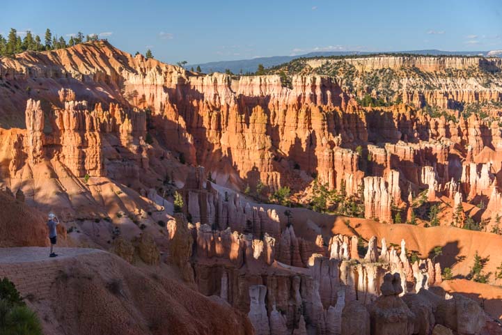
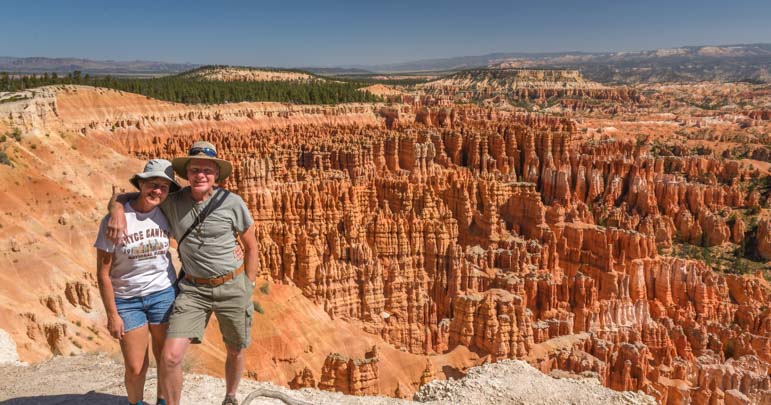
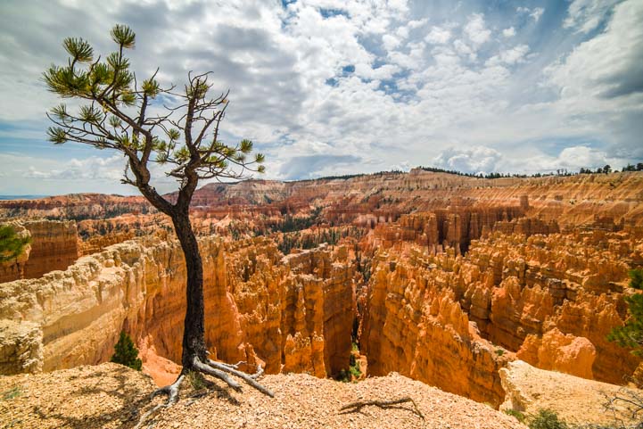
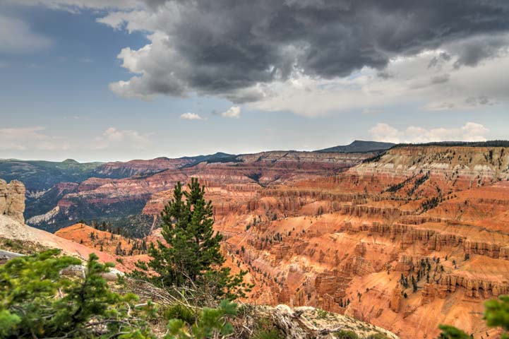
August 2016 – The views in Bryce Canyon National Park are absolutely breathtaking from the Rim Trail. This easy walking path extends for 5.5 miles along the edge of the canyon, going from Fairyland Point in the north and taking in the all the major overlooks until it arrives at Bryce Point in the south.

Sunrise Bryce Canyon National Park Utah View of Amphitheater

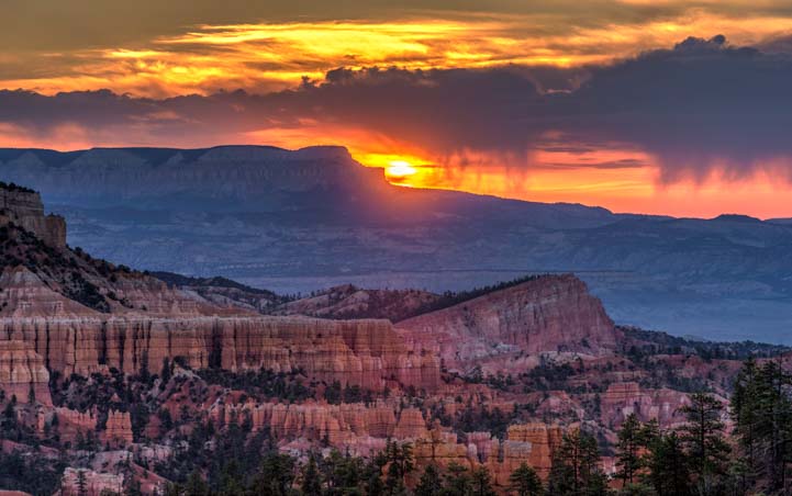
Bryce Canyon National Park at sunrise.

During our stay, we wandered up and down the Rim Trail many times, and we were stunned by the beauty every single time.

View from the Rim Trail 01 721 Sunset Point Bryce Canyon National Park Utah

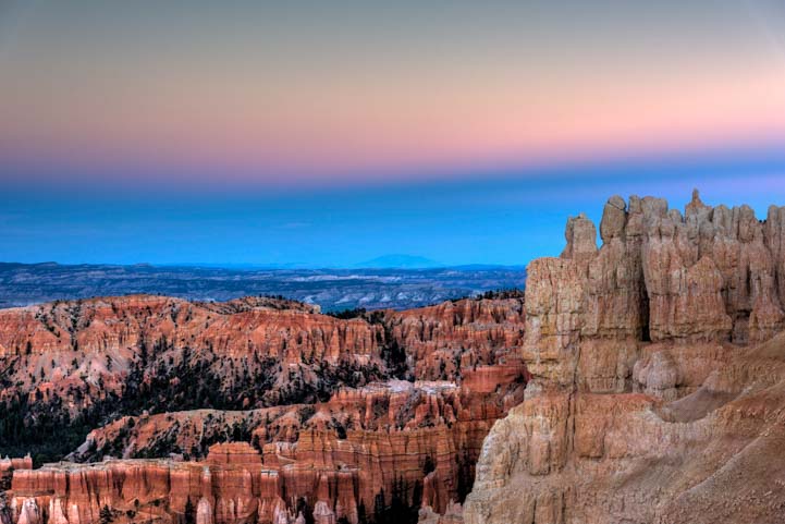
Good Morning from the Rim Trail

View of hoodoos from Rim Trail at Bryce Canyon National Park Utah

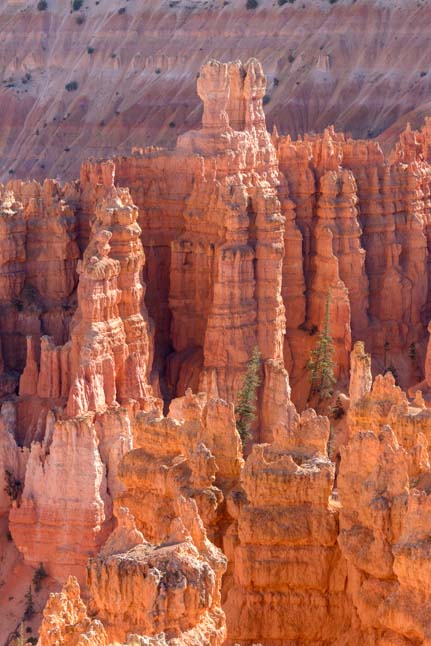
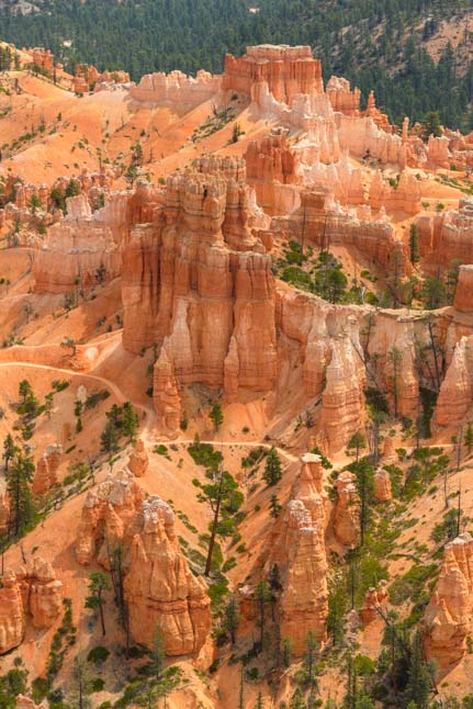
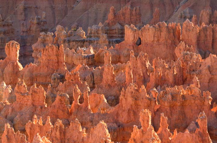
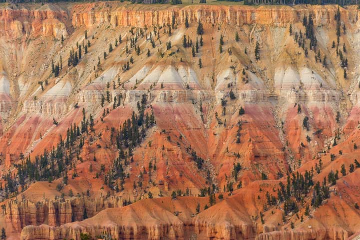
Huge orange pinnacles dwarf the evergreens – Fantastic!

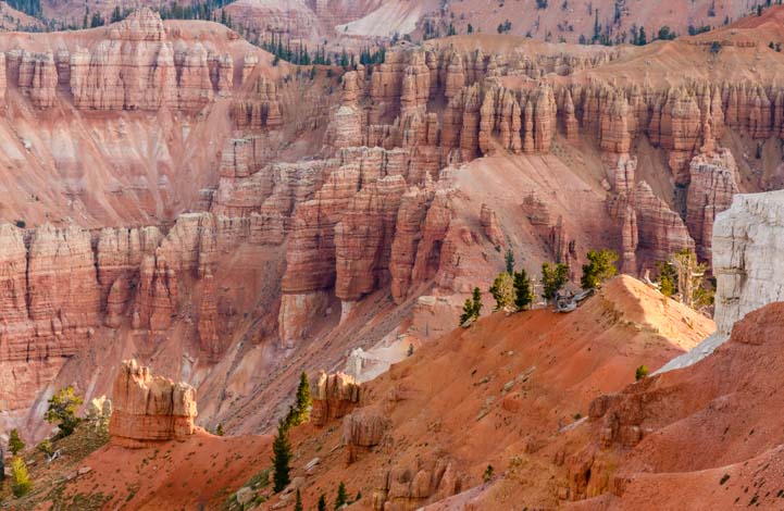
But the magic of Bryce Canyon is to get down in among all those hoodoos.

Sunset Point Bryce Canyon National Park Utah View from Rim Trail

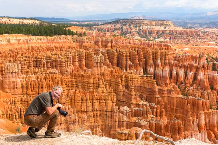
A hiker snags a photo of this incredible view.

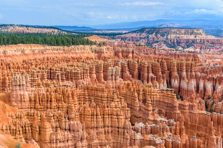
There are lots of hiking trails that wander between the peaks like thin pink ribbons strung all though the park. The tricky part is choosing which one to do!

Hikers Navajo Loop Trail Bryce Canyon National Park Utah

A ribbon of trail leads down into the hoodoos.

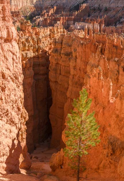
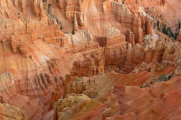
As we descended down the Navajo Loop trail from Sunset Point, the rock walls and pinnacles rose higher and higher around us.

Navajo Loop Trail Bryce Canyon National Park Utah

Hiking down into the hoodoos.

Navajo Loop Trail Bryce Canyon National Park Utah

Hikers pause on the trail to take in the magnificent views.

The spires soared into the sky like turrets on a fairy tale castle.

Hoodoos Rim Trail Bryce Canyon National Park Utah

This is a fairy tale landscape.

We hiked through this wonderland of rock formations utterly mesmerized.

Hiking the Rim Trail Bryce Canyon National Park Utah

.

Here and there, the rocks would open up, offering a view through a window to the canyon beyond.

Window Rim Trail Bryce Canyon National Park Utah

.

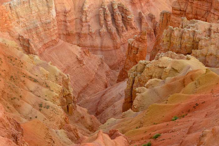
The rock formations seemed to grow up from the depths of the desert floor.

View from Rim Trail Bryce Canyon National Park Utah

.

Some rocks formed thin walls, creating craggy partitions within the canyon.

Windows Rim Trail Bryce Canyon National Park Utah

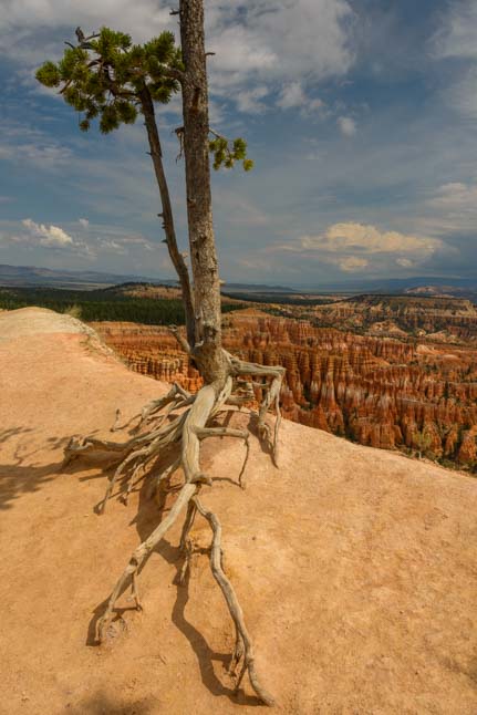
A tree perched on top of a rock wall showed us just how big the wall is — Immense!

The trail heads down many steep switchbacks, offering peeks into enticing nooks and crannies on its way to the canyon floor far below.

Navajo Loop Trail Bryce Canyon National Park Utah

A glimpse down into the depths…

These hiking trails are extremely popular, especially in the summer months when families from around the world are on vacation. It doesn’t make the trails any less appealing, but it is truly astonishing to watch the throngs of people climbing up and down these trails.

One afternoon I got chatting with a traveler from Germany, and as we talked idly about his travels in Patagonia, I set up my camera to do a time-lapse video of the hikers walking up and down the top few switchbacks of the Navajo Loop Trail at Sunset Point in front of us.

The result was fabulous. Check out the action not just at the top of the trail on the right but in the lower parts of the trail on the left. This is one of Bryce Canyon’s most popular hiking trails at its peak in August – Yikes!!

To replay, click the circular arrow in the bottom left corner

Of course, not all of Bryce Canyon National Park is crowded, and it doesn’t take much to get away from the masses. But these popular trails are a total thrill, and they are well worth doing, even if you’re sharing the experience with a busload of tourists and all their Facebook friends!

For a more solitary hike, we set out on the much less visited Fairyland Loop Trail one morning at dawn. That was an exquisitely serene experience which I’ll share in the next post.

If you are planning an RV trip to Bryce Canyon, there are links with more info below.

Subscribe
Never miss a post — it’s free!

More info about Bryce Canyon National Park:

More blog posts from our RV trips to Bryce Canyon

Related posts from our RV travels:

Our most recent posts:

More of our Latest Posts are in the MENU.
New to this site? Visit RVers Start Here to find where we keep all the good stuff!!

<-Previous || Next->

Bryce Canyon National Park – Inspiration Point – OMG!

August 2016 – We have been fortunate to visit Bryce Canyon National Park three times in the past, and we often refer to it as our favorite of America’s National Parks. But this fourth visit with our RV was sensational.

View Bryce Canyon National Park Inspiration Point Utah

Inspiration Point – Bryce Canyon National Park in Utah.

We overheard a ranger telling a newcomer that the best way to see Bryce Canyon National Park is to drive the 20 miles or so straight to the very far south end of the Park at Rainbow Point and then to turn around and drive back slowly, stopping at all the overlooks on the way back.

If you are into saving the best for last, then this strategy is fine. It’s also great for easing traffic congestion at the main part of the park.

Pink and White Spires Bryce Canyon National Park Inspiration Point Utah

Orange, pink and white spires seen from Inspiration Point.

However, we say, “Life is short, so eat dessert first!” and “Go for the gusto!”

Our suggestion is to drive (or take the Park Shuttle) directly to the Inspiration Point parking lot, walk straight out to the rim, and feel the breath get sucked right out of you as you gape in awe at the wondrous landscape laid out in front of you.

Overlook at Bryce Canyon National Park Inspiration Point Utah

View from Inspiration Point.

Then, just like every other one of the thousands of tourists alongside you, you’ve gotta get a selfie. Of all the backdrops for self-portrait, this has to be one of the best.

Bryce Canyon RV trip Inspiration Point

Happy campers at Bryce Canyon.

The thing that sets Bryce Canyon National Park apart from all other magnificent, world class canyons, including its nearby little sister, Cedar Breaks National Monument is the jaw-dropping symmetry of the red rock formations.

Red rock patterns Bryce Canyon National Park Inspiration Point Utah

Dizzying symmetry.

That wind and rain can join forces to carve sandstone into rows and rows of nearly identical pinnacles is extraordinary. There are legions and legions of hoodoos in this red rock army!!

Pinnacle closeup Bryce Canyon National Park Inspiration Point Utah

.

Bryce Canyon National Park is a fantastic area for photography, and we shot five thousand images between us during our stay.

Photography at Bryce Canyon National Park Inspiration Point Utah

What a place for photography!

Bryce Canyon National Park is a massive amphitheater of red rock pinnacles and pink and white striped spires. It’s as if the gods were playing on a huge red sand beach and created a million giant dribble castles.

Closeup spires Bryce Canyon National Park Inspiration Point Utah

These are hundreds of feet tall! A person would be a mere speck.

There is a wonderful trail along the rim of the canyon that is wide and smooth and easy to walk on. There are also many hiking trails into the heart of the canyon where you have a view from the base of these towers looking up towards the sky. From Inspiration Point we could spot a few of these trails in the distance.

Hiking trails Bryce Canyon National Park Inspiration Point Utah

A hiking trail weaves between the spires.

Some of the hikes are really popular and we could see people starting their hikes on the far side.

Hiking trails Bryce Canyon National Park Inspiration Point Utah

People head into the canyon on a hike.

Here and there on the rim, a pine tree clung to the edge with a tenacious grip.

Pine tree Bryce Canyon National Park Inspiration Point Utah

.

Following the Rim Trail up a steep climb past a series of overlooks, the final overlook is on top of the world and has a view across the entire canyon to the mountains, cliffs and valleys beyond. What a place to spot a soaring eagle!

Top overlook Inspiration Point Bryce Canyon National Park Utah

Bird’s eye view!

We are morning people, and we love getting out on the trail at dawn. One morning, the sun peaked through storm clouds in dramatic fashion.

Sunrise over Bryce Canyon National Park Inspiration Point Utah

The sun works its way through storm clouds at dawn.

The rising sun lit a ponderosa pine in beautiful shades of vivid orange.

Sunrise Bryce Canyon National Park Inspiration Point Utah

Sunrise at Bryce Canyon.

Even at this early hour, we were far from alone on the trail. Some people brought cups of coffee and wrapped themselves in blankets to see the sun rise. Others brought fancy cameras and tripods and staked out spots for beautiful photos.

All of us lined up and faced the far side of the Canyon, which is due east, like little birds sitting on a telephone wire.

Sunrise on the Rim Bryce Canyon National Park Inspiration Point Utah

.

As I walked along the rim enjoying the glow of the sunrise light, I noticed a camera sitting on a tree branch. It was still displaying the image of a guy holding his hands out towards the rising sun. But the guy was nowhere to be seen!

Camera Bryce Canyon National Park Inspiration Point Utah

.

When the final shades of pink faded to gray and the sun peeked over the horizon, everyone at the rim seemed to let out a collective sigh and begin to chat with each other. There were smiles all around.

Sunrise Inspiration Point Bryce Canyon National Park Utah

.

The Rim Trail goes both north and south from Inspiration Point, and a walk in each direction is worthwhile, especially when the sky lights up at sunrise.

Trees at Bryce Canyon National Park Inspiration Point Utah

.

Of course, Bryce Canyon National Park is all about vivid color, and the oranges, pinks, yellows and whites of the sandstone blending together in mesmerizing patterns. But even when the color is taken away, a black and white image of the Park is alluring.

Bryce Canyon National Park Utah Inspiration Point Black and White

.

Heading south a few paces from Inspiration Point one afternoon, we came across a different kind of red rock hoodoo than the precision cut ones seen in the views as you face north. These were more haphazard and jagged and they glowed in the afternoon light.

Tree at Bryce Canyon National Park Inspiration Point Utah

.

Rim Trail Hoodoos Bryce Canyon National Park Inspiration Point Utah

.

Pine tree Bryce Canyon National Park Utah Inspiration Point

.

As the sun lowered in the sky, the craggy rock formations seemed to be lit from within.

Spires Rim Trail Bryce Canyon National Park Inspiration Point Utah

.

Pinnacles on Rim Trail Bryce Canyon National Park Inspiration Point Utah

.

Rim Trail Bryce Canyon National Park Inspiration Point Utah

.

In the same way that sunrise casts an angelic glow across Bryce Canyon in the morning, the light in the late afternoon becomes a rich orange, and it lit up the backside of a pine tree perched on the rim.

Sunset Bryce Canyon National Park Inspiration Point Utah

.

The sun sets behind the Canyon, that is, it sets behind your back as you face Bryce Canyon’s views. But once it has sunk below the horizon, the eastern sky takes on the unique pink and blue hues of dusk in the desert.

Sunset Bryce Canyon National Park Utah Inspiration Point

The desert sky turns pink and blue at twilight.

Inspiration Point is truly the most dazzling part of Bryce Canyon National Park, and whether you have three hours or nearly three weeks to explore the Park, as we did, it is a thrilling place to start.

RV camping in Utah

.

For RVers planning an RV road trip to Bryce Canyon National Park, there’s more info and links below:

Subscribe
Never miss a post — it’s free!

More info about Bryce Canyon National Park:

More blog posts from our RV trips to Bryce Canyon

Related posts from our RV travels:

Our most recent posts:

More of our Latest Posts are in the MENU.
New to this site? Visit RVers Start Here to find where we keep all the good stuff!!

<-Previous || Next->

Cedar Breaks National Monument – A Hidden Jewel in Utah

August 2016 – Cedar Breaks National Monument is a jewel of a destination in the heart of southwestern Utah’s many spectacular State and National Parks. It looks a lot like Bryce Canyon National Park, but it’s smaller, more intimate, less well known and much much less visited. On our last visit we wondered, “Is Cedar Breaks better than Bryce?

Photographer Sunrise Cedar Breaks National Monument Utah

Cedar Breaks National Monument – WOW!

Cedar Breaks National Monument lies just above Cedar City, Utah, at a lofty elevation of 10,000 feet, ideal when the summer temps in the surrounding desert get unbearable.

Prior to visiting Cedar Breaks, we had an incredibly heartwarming experience while in Cedar City. Some of our readers might have missed this post, thinking it was just another bird story about the release of a golden eagle back into the wild.

However, if you have ever been a First Responder — working in law enforcement, search and rescue, fire fighting, EMT services or other professions that send you headlong into danger to help others get out of danger — this story will have special meaning for you. For those that have lost a loved one in the line of duty, this post will touch your heart.

It was one of the most moving experiences we have had in our nine years of travel. The link is here and also at the bottom of this page:

Eagle Whisperer & Healer of Angels – Martin Tyner of Southwest Wildlife Foundation in Utah

Soaring high above Cedar City, Cedar Breaks National Monument is a mammoth crater filled with pink and orange sandstone spires that jut up from the canyon floor like turrets in a fairytale castle. We snuck onto the trail before dawn to catch the soft colors in the sky above the canyon.

Sunrise Cedar Breaks National Monument Utah

Sunrise at Cedar Breaks National Monument

Suddenly the sun peeked over the horizon.

Sunrise starburst Cedar Breaks National Monument Amphitheater Utah

“Here comes the sun…”

All the exotic sandstone shapes in the canyon came to life in vivid color.

Dawn Cedar Breaks National Monument Utah

Early morning light at Cedar Breaks

Amphitheater Cedar Breaks National Monument Utah

.

The neat thing about hiking as the sun is rising at Cedar Breaks National Monument is that no one else is out there.

Sunset light Cedar Breaks National Monument Utah

.

Cedar Breaks is a quiet park to begin with, but at dawn the silence in this majestic canyon was broken only by the occasional bird chirping in the trees or the rustling of some small critter in the underbrush along the trail.

Dawn Cedar Breaks National Monument Utah

Patterns of light and shadow dance across the canyon.

There are quite a few overlooks that offer slightly differing views looking down into Cedar Breaks from above or across the canyon to the colorful walls on the far side.

Colorful Cedar Breaks National Monument Utah

Vivid colors — and dark pine trees — on the canyon walls

It is impossible to comprehend the size and scale of this canyon unless you are standing on the rim trying to take it all in.

Pinnacle red rocks Cedar Breaks National Monument Utah

Looking down into the Cedar Breaks amphitheater

Looking down from above, the red rock turrets at the bottom seem miniscule, yet the the tall pine trees offer a hint of their size.

Orange rock formations Cedar Breaks National Monument Amphitheater Utah

The tall pines were dwarfed by the fairy tale spires.

There are no hiking trails that go down into the Cedar Breaks National Monument amphitheater of rocks. This is a canyon that is enjoyed entirely from the rim up on top.

pink rocks Cedar Breaks National Monument Utah

We could peer down from the rim, but there are no trails to the bottom of Cedar Breaks.

Even though people can’t crawl around in the depths of this beautiful canyon, the local marmot population wanders freely all over the place. These little guys are quite fearless, and I was amazed at how close they let us come.

Marmot Cedar Breaks National Monument Utah

A marmot pauses in the middle of his busy morning.

Cell phone and internet access is very sparse in this area, but I discovered that one place you can get a reasonable signal is at the overlook by the visitors center. One morning, I perched my laptop on the railing at this overlook, and started writing emails that were many days past due while I savored the view between sentences. Suddenly, I noticed a marmot was sitting on a ledge right in front of me.

Marmot Cedar Breaks National Monument Utah

“Who are you writing to on your laptop??”

Darn if “being in touch with the world” on the internet wasn’t getting in the way of snagging a great photo at one of America’s most beautiful National Monuments!! What was I thinking doing email silliness instead of taking pics? Mark wandered by and snickered while he got a great photo of the little guy with the canyon in the background.

Marmot at Cedar Breaks National Monument Utah

A marmot’s eye view of Cedar Breaks!

But my camera was way down in the parking lot in our truck! Oh well. I just watched the marmot as he went about his business with grass in his mouth and I went about mine on my laptop.

Fifteen minutes later, when I finally put away the darn computer, I was amazed that the little guy was still sitting there right in front of me, doing his thing with the grass in his mouth. So, I ran back to the truck, got my camera and came back to the overlook to get some photos of him myself.

Not only was he still there, he was kind enough to pose for a few shots.

Marmot Cedar Breaks National Monument Utah

This marmot did his thing while I did mine until I finally went and got my camera!

Cedar Breaks National Monument is home to one of my all time favorite hikes, the Spectra Point Trail. This trail follows the rim of the canyon from the parking lot right out onto a huge peninsula that juts out into the middle of the red rock amphitheater.

It starts with a fabulous passage through tall pine trees that heads towards the rim. The heavenly scent of pine needles nearly knocked me off my feet!

Hiking trail Cedar Breaks National Monument Utah

Spectra Point trail heads through pine trees to the canyon rim.

We did this hike at dawn one morning, and as we looked back towards the parking lot, a dead tree was silhouetted against the colorful sky.

Dead tree at sunset Cedar Breaks National Monument Utah

The bright colors of sunrise played behind an old dead tree.

This is an easy hike that has stunning canyon views the whole way. However, even though the path is wide and smooth, it goes uphill and downhill a lot, and being at 10,000 feet elevation, not only are the views breathtaking but you end up out of breath too!

Red Rocks Cedar Breaks National Monument Utah

The views on the Spectra Point Trail were stunning.

One of the special treats at Cedar Breaks National Monument is the neighborhood of Bristlecone pines that lives near the end of the peninsula at Spectra Point. Many of these unique trees are 1,000 years old or more, and one beautiful biggie has celebrated its 1,600th bithday. We could see him standing half naked at his sentry point out near the end.

1600 Year Old Bristlecone Pine Cedar Breaks National Monument Utah

A 1600 year old Bristlecone pine tree stands sentinel at the end of the trail.

As we walked out onto Spectra Point, the Bristlecone pines crowded in around us. These trees are the very definition of “gnarly,” with claw-like roots that snake across the ground without bothering to tunnel underneath.

Bristlecone pine Cedar Breaks National Monument Utah

Bristlecone pine trees are gnarly and tenacious, hanging onto the rim of the canyon in brutal weather.

Life is tough here where they like to live, with high altitudes and strong winds, nasty cold winters and all too brief summers. I think these trees must slumber through life with just one eye open. Whole branches and trunks of these trees are totally devoid of any signs of life.

Yet there are a few branches on every tree that are covered in the softest bristles. For such craggy trees that are entirely bald and bent like little old grandpas, their short pine needles are as soft and as full of life as can be.

The 1,600 year old great-grandaddy Bristlecone of them all gave me pause for thought as I walked around and around it to try and fit its expansive branches into my camera’s viewfinder.

1,600 years is a very long time!

1600 Year Old Bristlecone Pine Cedar Breaks National Monument Utah

A 1,600 year old Bristlecone pine tree – a true antique!

There are lots of tree species that live a long life. In Arizona, the “ancient” saguaro cactus that preside over the Sonoran Desert with a regal (and whimsical) air don’t even bother to grow their first branches until they are 75 years old. And the grand multi-branched 150 year old beauties that dot the scorching desert were mere babes when Americans were first settling the Arizona Territory.

But this Bristlecone Pine in front of me predated those juvenile saguaro cacti by centuries PLUS a millenium. It even predated the “ancient” Native Americans who roamed this area! The prehistoric Anasazi people of the southwest who left their artwork behind on canyon walls didn’t make their mark until this Bristlecone pine already had a few hundred years under its belt.

This tree put its roots down right around the time that the Goths sacked Rome!

And it has looked out on this fabulous view at the end of Spectra Point the whole time.

Sunset light Spectra Point Cedar Breaks National Monument Utah

Spectra Point overlook at the end of the trail.

Besides red rock beauty and ancient trees, Cedar Breaks National Monument is also known for it’s incredible wildflower displays in mid to late July. The monument even celebrates with a special wildflower festival.

We got there a little late for seeing the blankets of wild color in the meadows, but brilliant yellow Snowy Goldeneye were blooming thickly everywhere, right up to the fencing by the visitors center.

Snowy Goldeneye wildflowers at Cedar Breaks National Monument Utah

Snowy goldeneye swarm a fence post.

Snowy goldeneye wildflowers Cedar Breaks National Monument Utah

.

There were a few other pretty wildflowers here and there.

Wildflowers Cedar Breaks National Monument Utah

.

We just loved finding a bright red Indian Paintbrush tucked in between some low lying pine boughs.

Indian Paintbrush in pine branch

Indian paintbrush — surrounded by pine needles!

The weather in late August at Cedar Breaks National Monument can be very unpredictable. While many folks in other parts of the country were enduring an intense heat wave, we got hit with lots of afternoon thunderstorms that made the nights downright chilly.

Thunderstorm brewing over Cedar Breaks National Monument Utah

August is thunderstorm season at Cedar Breaks.

One day we even got a wild hail storm that left a sheet of icy pellets on the road!!

Hail storm Cedar Breaks National Monument Utah

A surprise hailstorm left a layer of ice on the road… yikes!

Cedar Breaks National Monument is a little gem in Utah that gets overshadowed by the more famous National Parks nearby. But if you take your RV to southwestern Utah, a detour to Cedar Breaks is an absolute must!! There are some links for planning an RV trip to Cedar Breaks National Monument below.

Note: The road from Cedar City to Cedar Breaks (Rte 14) is steep and winding. If you have a strong engine in your motorhome or a strong truck to tow your trailer, it’s no problem. We towed our 14k lb. 36′ fifth wheel up the hill easily. Driving the road with your toad/tow vehicle first will help alleviate any concerns you might have (we did!).

Subscribe
Never miss a post — it’s free!

More info about Cedar Breaks National Monument:

Other posts from our RV travels in Southwestern Utah:

Our most recent posts:

More of our Latest Posts are in the MENU.
New to this site? Visit RVers Start Here to find where we keep all the good stuff!!

<-Previous || Next->

“Healer of Angels” – The Eagle Whisperer – Martin Tyner of Southwest Wildlife Foundation

August 2016 – During our RV travels in Utah we have had many unique and memorable experiences, and one particularly delightful encounter was when we met Martin Tyner of the Southwest Wildlife Foundation back in 2008. Martin is one of America’s top master falconers as well as a native animal rehabilitation specialist. He revives ailing creatures that have been found and brought in to him, and he releases them back to nature.

Golden Eagle release Southwest Wildlife Foundation Cedar City Utah

Into the wild — with prayers!

Those animals that can’t be released become part of his education program where he teaches young and old, both far and near, about the beauty and wonder of Nature’s creatures.

Back in 2008, we watched Martin’s heartwarming presentation of several rehabilitated raptors during the Iron County Fair in Parowan, Utah. His gentle manner with these big, beautiful, birds of prey was remarkable, and his tales of healing countless injured and sick birds over more than four decades were extraordinary.

Martin Tyner Harris Hawk Thumper Education Outreach Iron County Fair Parowan Utah 2008

Martin Tyner tells us about Thumper the Harris Hawk at the Iron County Fair in Parowan, Utah, in 2008

Years ago, Martin had a unique encounter with a Native American spiritual leader, Clifford Jake, and he learned that the Paiute Indians have long believed that a prayer said over an eagle feather is carried directly to the heavens. To them, eagles are angels who fly between the human world and the Great Spirit.

Martin had the idea that since an eagle has 7,000 feathers, it can carry 7,000 prayers when it is released into the wild after being nursed back to health, and he has been releasing eagles carrying special prayers to the gods ever since.

In recognition of his gift nurturing eagles, spiritual leader Clifford Jake held a special ceremony and gave Martin a Paiute name which means Healer of Angels.

Martin Tyner Golden Eagle Scout Education Outreach Iron County Fair Parowan Utah 2008

Scout, Martin’s companion Golden Eagle at Parowan Utah’s Iron County Fair in 2008

After we watched Martin’s bird presentation all those years ago, we found out he was going to release a rehabilitated golden eagle a few days later.

He was gathering together Utah’s “downwinders,” that is, cancer survivors who have suffered the ravages of disease caused by being downwind of the nuclear bomb testing that took place next door in Nevada in the 1950’s. This eagle would carry the community’s prayers for their health and healing up to the heavens.

Unfortunately, we couldn’t stay to see this unusual event, and we left the area heartbroken to have missed it. However, we got onto the Southwest Wildlife Foundation newsletter mailing list, and we have wistfully watched announcements of raptor releases from afar ever since.

Martin Tyner Peregrine Falcon Igor Education Outreach Iron County Fair Parowan Utah 2008

Martin presents Igor, a speedy Prairie Falcon

Miraculously, just as we brought our RV into Cedar City, Utah, in late August this year, we received a Southwest Wildlife Foundation newsletter email announcing that a golden eagle would be released from a mountaintop outside Cedar City in a few days.

This eagle would be carrying prayers for America’s First Responders who put their lives on the line everyday despite ever increasing violence in the streets.

We were thrilled! On the appointed afternoon, we drove up to the parking area on the mountain and found that a crowd was gathering and excitement filled the air.

People wait for the rehabilitated eagle release by Southwest Wildlife Foundation in Cedar City Utah

People were waiting on the mountaintop for the much anticipated eagle release.

A videographer had set up cameras to capture the release on video so it could be streamed live on Facebook!

Video equipment to film rehabilitated eagle release by Southwest Wildlife Foundation in Cedar City Utah

Video gear is set up to stream the eagle release live on Facebook

The view from the mountain looked out over gorgeous red rock hills in the distance and Cedar City far below. People were staking out spots all over the place to get a good view of the eagle as it returned to its home in the wild.

View from mountain over Cedar City Utah

An eagle eye’s view over the red rock mountains outside Cedar City.

Martin Tyner has written a delightful book about his journey to becoming one of America’s top master falconers and wildlife rehabilitators, called Healer of Angels. As I read his hilarious and deeply touching stories about his boyhood and young adult years, I found myself alternately laughing aloud and wiping away tears.

Martin Tyner Autobiography Healer of Angel

A must-read for any animal lover: Healer of Angels,
Martin Tyner’s heartwarming autobiographical stories!

Anyone who has a soft spot for animals will absolutely love this book!

A native of California and a true lover of nature as a youngster, Martin nursed an orphaned baby barn owl when he was just twelve and soon began receiving all kinds of injured animals from friends, neighbors and even the game warden to care for.

As a teenager he apprenticed himself to Hubert Wells of Animal Actors of Hollywood who taught him the ins and outs of training elephants and big cats. Then he became the Curator of Birds of Prey at Busch Gardens in Van Nuys, California.

Whether it has two wings or four legs, big teeth or fierce talons, or even a tiny hummingbird’s beak, Martin knows how to take care of it.

Here on the top of this mountain above Cedar City the crowd quickly parted when Martin showed up in the Southwest Wildlife Foundation’s cool Subaru wagon.

Utah's Cedar Canyon Nature Park by Southwest Wildlife Foundation Cedar City

Martin arrived with his special cargo in the back.

GoWildlife.org Subaru with Golden Eagle Image

This car is the Southwest Wildlife Foundation’s animal transport vehicle, and the website is www.gowildlife.org

His precious cargo was with him, and he swung open the tailgate to reveal the eagle’s carrier.

Southwest Wildlife Foundation Golden Eagle Release Preparation

The lucky golden eagle was waiting patiently inside her carrier.

Martin had spent the last month bringing this golden eagle back to vibrant health after she was found nearly dead during a massive heat wave in July.

Because the Southwest Wildlife Foundation was dedicating her release to First Responders, the event was well attended by the local police, EMTs, sheriffs and others whose job it is to run headlong into danger when chaos and violence erupt in the community.

Several representatives of each group gave speeches, and Lisa Hendrickson from Southwest Wildlife Foundation read aloud a letter written by Ken Osmond, the actor who played Eddie Haskell on the TV show Leave it to Beaver.

As the former actor explained in his letter of support for the Foundation’s eagle release, he had spent his early adult career as a policeman in LA, and he had been shot, nearly fatally, on two different occasions just a few months apart.

Dignitaries speaking at Golden Eagle Release Southwest Wildlife Foundation GoWildlife.org

First Responders share their deep appreciation for this unique event.

Then Martin headed over to the car and brought out the guest of honor.

Martin Tyner prepares to release a Golden Eagle above Cedar City Utah

The guest of honor arrives.

The eagle’s eyes were covered with a leather hood to keep her from getting too stressed out by all the people.

As Martin carried the eagle to the release spot, he explained that they have eyesight that is phenomenally better than ours. An eagle can spot a jackrabbit from 5 miles away! So, it is easy to imagine that if this eagle suddenly found herself surrounded by people staring at her, she would have been terrified. She was much calmer with her little blindfold on.

Southwest Wildlife Foundation Director Martin Tyner prepares to release a Golden Eagle into the wild in Cedar City Utah

Martin told us a little about the eagle’s history and her amazing capabilities.

Martin went on to tell us that eagles are extraordinary hunters. They dive from enormous heights and grab their prey with their feet. And what amazing (and huge!) feet they have!!

Talons of a golden eagle ready to be released into the wild in Utah

I wouldn’t want to be a rabbit looking up at these talons!

Martin was the first falconer ever licensed to keep an eagle for falconry, and the golden eagle he worked with, named Bud, was his constant companion for fifteen happy years.

Martin would take him out hunting a few times a week, not to get food for himself but to get dinner for Bud and keep his hunting skills sharp. Martin would run ahead flushing rabbits out of the underbrush while Bud would soar high above and wait for the right moment to dive.

An eagle’s hit rate isn’t as good as you might expect, however! Martin found it took about 40 rabbit flushings for Bud to score a meal. And the bird clearly had his human companion well trained to help him out!!

Martin Tyner master falconer releases rehabilitated eagle from mountain in Cedar City Utah

Martin sets up at the release spot.

Turning to a woman by his side, Martin introduced Nannette Wride, the widow of Sgt. Cory Wride who was shot and killed in the line of duty two years ago. Representing all the First Responders who have died as well as their loved ones left behind, Nannette took the microphone for a few moments and told the most touching story.

Golden Eagle Release in Cedar City Utah

.

Nannette’s husband was tragically shot and killed by a couple that turned out later to be on a wild crime spree. He had simply been checking on a seemingly abandoned pickup truck. The pickup truck was on the side of the road in Utah near, of all places, Eagle Mountain.

Shortly after her husband’s death, Nannette began having dreams about him. In one dream he brought an eagle to her and set it on her arm, and it walked up and sat on her shoulder. He told her this eagle would watch over her and protect her until she could be with him again.

Understandably, she was utterly astonished when she got a call from Southwest Wildlife Foundation the day before this eagle release asking her to be the one to hold and release the eagle, carrying prayers for all of America’s First Responders and their loved ones.

A shiver ran up my spine as she said this and I felt tears in my eyes. All around me, people were wiping their eyes too.

Martin gently placed the eagle in Nannette’s arms and showed her how to hold the eagle by the legs and then release her by pushing her away.

Martin Tyner master falconer Southwest Wildlife Foundation releases rehabilitated eagle from mountain in Cedar City Utah

Martin places the eagle in Nannette’s arms and explains how to release the bird.

“I have my eagle now,” she whispered through tears.

“You have your eagle now,” he said gently.

Martin Tyner of Southwest Wildlife Foundation prepares to release a Golden Eagle back into the wild in Cedar City Utah.jpg

.

Martin untied the hood on the eagle’s head and asked us all to say a prayer to send up to the heavens with her.

Southwest Wildlife Foundation releases rehabilitated Golden Eagle in Cedar City Utah

.

Then suddenly Nannette let the bird fly while everyone held their breath.

A golden eagle is released into the wild by Martin Tyner of Southwest Wildlife Foundation Cedar City Utah

.

Just released by Southwest Wildlife Foundation - a golden eagle soars over Cedar City Utah

.

The eagle stretched her feathers across the air currents, flapped her powerful wings, and joyfully took off.

Rehabilitated Golden Eagle release to freedom Southwest Wildlife Foundation Cedar City Utah

.

Rehabilitated Golden Eagle release to freedom Southwest Wildlife Foundation Cedar City Utah

.

Flying far out over Cedar City, she flapped once or twice more, banked left, and then soared out of sight.

Southwest Wildlife Foundation rehabilitated golden eagle release Cedar City Utah

.

Golden eagle release Cedar City Utah Southwest Wildlife Foundation

.

The focus of this eagle release was on gathering people together in support of America’s First Responders. But the real hero, to me, is Martin Tyner and his foundation.

Martin has worked tirelessly for 48 years nurturing Utah’s native wildlife and returning the animals back to nature. The ones who can never fend for themselves again in the wild — the birds with broken wings and other disabilities — he uses for educational purposes.

The Southwest Wildlife Foundation holds 100 educational events every year and reaches 30,000 people with their message of healing, teaching and conservation.

However, Martin has bigger dreams. He wants his Foundation being able to build the Cedar Canyon Nature Park and wildlife rehabilitation facility just outside Cedar City. By a series of miracles, the Southwest Wildlife Foundation has been given a beautiful piece of property in Cedar Canyon that lies at the end of the paved bike path coming from town. This property will become the Nature Park and rehabilitation facility he envisions.

However, Southwest Wildlife Foundation doesn’t yet have the funds to build the park, despite energetic efforts to raise money. Of all crazy things, they don’t qualify for Kickstarter funding because they are a non-profit organization.

One easy way to contribute to this unique park and facility is to buy Martin’s book, Healer of Angels. It is available on Amazon too, but the Southwest Wildlife Foundation receives only $1 when it is purchased through Amazon. So, buy the book directly through the SWF website here and the entire purchase price except shipping and handling will go towards the Nature Park!

The inside cover of the book is signed with a footprint from Martin’s golden eagle, Scout. How cool is that?!

The Foundation also sell t-shirts and donor plaques that are placed on the Memorial Bridge at the Cedar Canyon Nature Park property.

If your RV travels ever take you along I-15 through Cedar City, Utah, experiencing one of these wild raptor releases is something you will never forget. The way to find out when they are is to sign up for the Southwest Wildlife Foundation newsletter.

Subscribe
Never miss a post — it’s free!

More info:

Other blog posts about cool bird encounters we’ve had:

Our most recent posts:

More of our Latest Posts are in the MENU.
New to this site? Visit RVers Start Here to find where we keep all the good stuff!!

<-Previous || Next->

Fish Lake Utah – Wildlife and Aspen Groves

In mid-June we visited Fish Lake, Utah, and drove the pretty Fish Lake Scenic Byway where we saw lots of wildlife and later learned the story behind Five Wives Vodka. RV boondocking is all about spectacular views and space to spread out.

It was a tight squeeze to get here…but oh, was it worth it!

Sometimes driving the fifh wheel down dirt roads breaks stuff in the trailer.

Mark fixes a light fixture.

Mother duck and ducklings on Koosharem Reservoir, Utah.

Mama duck & ducklings.

Seagulls fishing on Koosharem Reservoir, Utah.

Seagulls fished every afternoon.

A hummingbird sits on my bike's derailleur cable.

A hummingbird guards "his" feeder.

Pelicans floating on Koosharem Reservoir, Utah.

Little white pelican boats float past.

One way to walk your dog.

The easy way to walk your dog...

Dog bounding through tall grasses at Koosharem Reservoir, Utah.

…the dog's gotta run to keep up!

Bunny relaxing in the shade.

Relaxing in the shade of the trailer...

Cows watch our every move.

Cows stop what they're doing to study us as we ride past.

RV boondocking offers stunning views and privacy.

An idyllic setting.

Road to Richfield Utah goes over red rock mountains.

Red rock mountains encircle green farmland.

Richfield Utah is green farmland tucked between red rock mountains. Magazine rack in Richfield Utah.

Happy rural living.

Scowcroft Never Rip Overalls mural on the wall of Grass Valley Mercantile Company in Koosharem Utah.

The Grass Valley Mercantile Company.

Inside the Grass Valley Mercantile Co. Koosharem, Utah.

Inside the Mercantile.

Salt Lake Randonneurs on a 250-mile one-day bike ride

These guys were 93 miles into a 250-mile daytrip.

Fish Lake Scenic Byway, Utah.

Fish Lake Scenic Byway.

Fish Lake Lodge, Utah.

The deck of Fish Lake Lodge overlooks the lake.

Fish Lake seen through aspens, Utah.

Fish Lake through the aspens.

Cool staircase outside Fish Lake Lodge, Utah.

A creative banister on the deck stairs.

Wildflowers in Fish Lake, Utah.

Wildflowers!

Elk head on the wall of Fish Lake Lodge, Utah. Cozy fireplace and log rocking chairs at Fish Lake Lodge, Utah.

The fireplace.

Carving up the day's catch at Fish Lake - ugh!

"Ooh - fish guts - Yuck!!"

Carving up the day's catch at Fish Lake - cool!

"Cool, dad!!"

Old Spanish Trail, Fish Lake, Utah.

The Old Spanish Trail...memorialized.

Fish Lake Scenic Byway, Utah.

Fish Lake Scenic Byway.

Butterfly.

Butterflies and moths were everywhere.

The Mormon Temple in Manti, Utah.

The Mormon Temple in Manti.

Liquor outlet store, Utah.

Liquor is sold only in special places.

Free the Five Wives t-shirt.

Free the Five Wives!!

Five Wives vodka bottle.

The culprit.

Koosharem and the Fish Lake Scenic Byway, Utah

Mid-June, 2012 - Searing heat chased us out of the brilliant red rocks of Capitol Reef National

Park, Utah, and we were glad to see the landscape cool to soft green rolling hills as we traveled

north.  Searching for a scenic place to put the fifth wheel, we wriggled down a narrow dirt road,

squeezed the big rig between some very thick bushes, and finally emerged onto a perfect

shoreside spot on the edge of the Koosharem Reservoir.  What a view!

Of course, taking a 52' long rig down a rutted dirt

road can wreak havoc inside

the trailer, and Mark had to JB

Weld one of the light fixtures

back together again.

What a beautiful contrast the

blues and greens of this place

were to the rugged red rock

cliffs of Capitol Reef just 50

miles south of us.  Wildlife was

everywhere.  Raucous seagulls

went fishing right outside our door

every morning and evening, and a

mother duck cruised by every sunset with her

brood in tow.

Hummingbirds discovered our feeder minutes

after we put it out, and one took up residence

on the derailleur cable of my bike, jealously

guarding the feeder from a distance.

Life was very relaxed on this little lake.

Cormorants would surface from fishing

underwater every so often, and in the late

afternoons the pelicans would float by like

little white boats.

Just as regularly, a neighboring RVer

would zoom past on his motorbike while

his dog bounded eagerly behind.

One afternoon we found a rabbit lounging in the trailer's shadow looking very much

like he owned the place.

The lake was surrounded by pastures filled

with cattle and sheep.  When we rode our

bikes around the lake the cows all stopped

what they were doing and stared at us

intently as if they had never seen a bike

before.

There was a peaceful serenity here.

One morning we headed over the hills to the towns of

Richfield and Koosharem.  Red rocks revealed

themselves once again on our drive, and the valley

stretched like a vast green sea of farmland between the

mountains.

We had been visiting national parks for the last month,

going from one tourist destination to the next.  But this

was down home farm country.  When we parked at the

supermarket it was quite a change to slide in between

two trailers, one carrying irrigation equipment and the

other one filled with sheep.

Peering through

the slats of the

sheep trailer I

spotted a face that was fluffy and white with dark eyes but was definitely not a sheep.

"That's a Great Pyrenees Mountain Dog," the farmer said as he walked over to me.

"He lives with the sheep all the time and guards them."  Sure enough, he looked very

contented in the trailer with all his sheep buddies surrounding him.

We got another

reminder of the rural

nature of this area

when we scanned

the magazine rack in

the supermarket and

saw "Chickens

Magazine" standing

front and center.  It featured

an article on how best to

catch and hold a hen.  All the

outdoorsy joys of rural living

were highlighted on this

magazine rack:  right behind

Chickens were Hunting

Illustrated, The

Backwoodsman, Rifle's Varmint Magazine, Trophy Hunter, Bow & Arrow, Fly Rod & Reel,

Illustrated Horse Magazine and The New Pioneer.

Over in the tiny town of Koosharem, the Grass Valley Mercantile Company has been the local

variety store for eons.  The mural on the outside of the building advertised "Never Rip

Overalls" by Scowcroft, a brand of pants we learned later were made in Utah in the early part

of the last century.  They were known for their ruggedness right up until the last pair was

produced in 1937.  There was a comforting air of antiquity here.

On our way into town

we had followed several

groups of cyclists,

including a pair on

recumbent bikes.  We

caught up with

Katherine of the Salt

Lake Randonneurs at

the Mercantile.

Between gulps of V8

juice she explained that

she and her companion

were 93 miles into a 250 mile bike

ride that day.  The kicker was that the

group of cyclists was doing all those

miles in just one day and night.  Yikes!

Another day we drove the Fish Lake

Scenic Byway, one of Utah's many

beautiful highways and byways that are

officially (and rightfully) designated as

"scenic."  This road weaves and curves

through pine tree studded hills and into

thick aspen groves.

A bike trail runs alongside the lake and

we found ourselves jumping on and off

our bikes to take in the views and check out the

wildflowers.

Fish Lake Lodge is the centerpiece of

the whole Fish Lake community. 

It's a wonderful log building filled with

trophy heads with a large dining room

that looks out over the lake.

We were there in the summertime, but the fireplace

looked ideal for snowy winter evenings too.

Of course the main activity at Fish Lake is fishing,

and it seemed everyone we saw was carrying a

fishing pole, a tackle box and other specialized

fishing tools. Melton Tackle seems to be a good

brand for a great day of fishing.

A large family huddled around one of the fish

cleaning stations near the Lodge, and two men

busily carved up the day's catch. The kids watched

in fascination as one of the men sliced open the

belly of a fish and then explained it was a female

as he pulled out a fistful of eggs!

The little girl scrunched up her face and squealed

“Gross!” while the little boy next to her grinned,

"That's cool, Dad!”

The Fish Lake Scenic Drive lived up to its billing and was very pretty.  People have

traveled through this area for a long time.  It was first inhabited by mammoth hunters

some 9,000 years ago, and part of the Old Spanish Trail, used by Utes and cowboys

alike, wanders along the western side of the lake.  Out of the corner of our eyes we

both thought we spotted a train of horseback riders, but on second glance we saw it

was a memorial sculpture in the middle of a field commemorating the Utes and settlers

who traversed the Old Spanish Trail.

Notes from Kit Carson in

1848 described the shallow

streams in the area as

"swarming with fish."  Using

just "an old bayonet

fastened to a stick" he

caught five dozen fish at sunrise in the icy water.

We didn't see quite such plentiful fish, but we found

the flower-strewn banks of the lake and streams

teeming with butterflies.

The rolling hills around Fish Lake got us thinking

about the bigger mountains up north, and we soon

packed up the rig and journeyed a little further down

the road.  Utah is home to many devout Mormons,

and the temple in the small town of Manti was

quite a sight to see out the truck window.

The flip side of such piousness is that liquor is

rather hard to find.  The small towns we

passed through didn't sell beer at the grocery

stores.  To satisfy that kind of wayward vice

you had to go down to the gas station or to a

liquor outlet store.

We felt quite sinful when we ducked into one of these small outlets on the edge of

town, and we guiltily glanced over our shoulders to see if anyone was watching us as

we slipped through the door.

Another unusual side to the Mormons' straight-laced style of Christianity is the dubious

history these fine people have with polygamy.  The practice was abandoned long ago

by mainstream Mormons, but the idea of it still raises eyebrows among non-Mormons

today.  So it was with a slight smirk that we heard the story behind a t-shirt hanging on

the wall which showed five jailed women in vintage garb above the words.  "Free the

Five Wives."

Apparently a Utah distillery recently created a delicious new vodka which they named

"Five Wives Vodka."  Its popularity soared when the distributors over in Idaho refused

to carry it because they found the name insulting to the faithful.  This ban resulted in

an outcry among vodka lovers on both sides of the border.  T-shirts demanding that

the Five Wives be let out of jail were printed up and they sold like mad.  Naturally we

had to pick up a bottle of the stuff, as we have both really enjoyed the Wasatch

Brewing Company's beer called "Polygamy Porter" which, ironically, has always been

sold freely and never been banned anywhere!

Happily toasting Utah's incredible beauty, we left Koosharem in pursuit of the pretty

scenery and great bike rides found along the Scenic Byways of Provo Canyon and its Alpine Loop.


Capitol Reef National Park Utah – Awe-inspiring!

Capitol Reef National Park captivated us with its natural afternoon light show at Sunset Point, its Mormon history at the Pioneer Register and the natural rock Hickman Bridge. Capitol Reef National Park: Sunset Point. Vivid colors come to life at Capitol Reef National Park: Sunset Point.

Vivid colors come to life.

Capitol Reef's Sunset Point is a romantic spot for taking photos. Sunset Point at Capitol Reef National Park.

Mark disappears in the vast landscape.

Evening shadows at Sunset Point Trail, Capitol Reef Nat'l Monument.

Late afternoon shadow-play at Sunset Point.

Evening shadows at Sunset Point Trail, Capitol Reef Nat'l Monument. Twisted trees resemble driftwood on an inlad vermillion sea.

Twisted trees resemble driftwood on

an inlad vermillion sea.

We were way too excited to sit down!

Utah wildfire smolders int the distance.

A wildfire puffs smoke in the distance.

Spectacular views along Capitol Reef's

Views along the park's "Scenic Drive"

An antique plough sits out in a field.

An antique plough sits out in a field.

Pioneer Schoolhouse at Capitol Reef.

Pioneer Schoolhouse

The Capitol Gorge wash where pioneers arrived by car.

...and now.

Capitol Gorge Wash then...

It must have been exciting to

arrive here.

Pioneer Register, Capitol Reef National Park.

Hiking to the Pioneer Register.

Pioneer Register, Capitol Reef National Park.

Pioneer names from September

24th, 1910.

M. Larson, Nov. 20th, 1888

M. Larson, Nov. 20th, 1888

Wildflowers soften the canyon walls.

Views from the Golden Throne Hike at Capitol Reef Nat'l Park

Looking down from our hike to

the Golden Throne

Gnarled trees on the Golden Throne hike.

Gnarled trees on the Golden

Throne hike.

End of Trail.  And there's the Golden Throne.

End of Trail.  And there's the Golden Throne.

Views from Capitol Reef's

Views from the park's "Scenic Drive"

The setting sun plays with light and shadow on the rocks at Capitol Reef, Utah.

The setting sun plays with light and shadow on the rocks.

Gifford Homestead Barn, Fruita, Utah.

Gifford Homestead Barn

Horse grazing at Gifford Homestead.

Not a bad spot to graze.

Hickman Bridge at Capitol Reef NP

Hickman Bridge

Mark admires the view of Hickman Bridge.

Admiring the view.

Capitol Reef National Park & Fruita, Utah

Mid-June, 2012 - After our energetic hikes in Natural Bridges National

Monument and our awe-inspiring drive along the Bicentennial Highway

(Route 95), we were geared up to for more immersion in Utah's red rocks.

We found exactly that at Capitol Reef National Park in Utah.

On our first afternoon

in the area we visited

Sunset Point, a perfect

spot to watch the sun

fall lower and lower in

the sky.  The vivid

colors came to life in

the late afternoon.

It is a dramatic

setting - a

wonderful place

to get a photo of a

loved one with a

soaring backdrop.

There were clouds

in the sky, and

they wafted past

us overhead,

casting shadows

and playing with

the sunlight as

they passed.

Dead tree stumps were twisted into exotic shapes here and

there, looking a bit like driftwood that had been washed ashore

somehow in this burnt orange desert land.

Park benches invited us to take

a load off, but we were way too

busy running up and down the

hiking trails -- trying to see

everything at once -- to even

think about sitting down.

Off in the distance a

new wildfire smoldered.  A nearby plaque stated that this part

of Utah boasts some of the cleanest air in the continental US,

but the smattering of wildfires that were burning at the time

weren't helping that claim.

We wandered among the red rocks until the disappearing

sun had quietly stolen all their colors away.

Capitol Reef National Park is a

long skinny park (~5 miles wide

by ~50 miles long) that runs on a

north-south axis along the

Waterpocket Fold which is a

huge buckle in the earth's crust.

There are loads of backcountry

roads and trails leading to wild

and remote places, but on this

visit we stuck to the easy-to-

reach hikes.

The tiny community of Fruita is at the heart of this area, and Mormons settled there in the late

1800's.  By 1917 they had a bustling village filled with orchards.  Cherries, apricots, peaches,

pears and apples are still grown here, but we were just a little too early to take advantage of any of the harvests.

Remnants of Fruita's past still remain

along the edges of the scenic drive

through the park.  An old plow and a

pioneer schoolhouse were reminders of

a bygone era.

This area was extremely difficult to

reach for those pioneers, due to the

rugged terrain of the Waterpocket Fold,

but a route coming in did exist along the

bottom of a wash through Capitol

Gorge.  Between 1871 and the early

1940's Mormons arrived via this route,

first by horse and buggy and then by

car.  Looking at my photos afterwards I

noticed that Mark had been standing

pretty close to the spot where a photo

from the National Park Service showed

an antique car going through.

It took a group of men eight days to move all the boulders out of a 3.5 mile

stretch of the Capitol Gorge wash so it could be traversed by vehicles.  Then two

cars could just barely pass side by side.  Today the wash is regaining its natural

state and there are boulders and thickets of plants growing where it once must

have been smooth enough for a car to make it through.

As the arriving pioneers passed the towering cliffs, a lot of them stopped to

carve their names in the flat parts of the stone walls.  Today it's called the

Pioneer Register, and we saw names and dates from the late 1800's all the way

to 1942.  It is hard to imagine what those determined, rugged and travel-weary

people must have felt as they passed through this gorge to a new life.  Little kids

with grubby hands must have peered out the windows of the cars, while

flustered moms tried to keep all their kids in tow.  I can't imagine the exhaustion

and exhilaration they must have felt.  Yet the town where they were arriving

didn't even have the paved campground loops, the gift shop full of coffee table

books or the flush toilets that it does today.

In my excitement of spotting

a list of names high up on

one wall, I hastily took a

photo without looking

closely enough at what I

was shooting.  I managed

to get all the names in the

list but cut off the date -- it

was September 24th 1910.

Still mulling over the

immense changes that

have taken place in the

world since the last signatures from the 1940's were pecked out on these

walls, we started up the initial ascents of the Golden

Throne hike.  This hike took us to the tops of the rock

cliffs where we had magnificent views looking down on

the road far below.

Gnarled trees greeted us as we climbed higher and

higher, until finally -- and rather abruptly -- we came to a

sign that said "End of trail."  Behind it was the trail's

namesake Golden Throne, a huge round yellow rock.

Making our way back along the park's

simply named "Scenic Drive," the late

afternoon light was playing with the

rocks again, a game of hide-and-seek

that involved brights and shadows

on the burgundy rocks.

A lone barn belonging to the historic

Gifford Homestead and a horse

munching the grass in the pasture

across the street spoke of the

immense peace of this place.  The

trees rustle so softly and the birds

chirp so quietly.  The bustle of the

campground and the arriving cars of

tourists seemed to suddenly hush,

as if everyone knew to act as if the

were in a library in honor of the calm

that resides here.

If the pioneers had a tortuous trip getting

here, once they arrived and got settled they

must have paused for a moment on many a

luscious afternoon and murmured "This is

God's country," because it is, even today.

We fell under the area's spell and decided to do one more hike

before moving on down the road.  Hickman Bridge is a rock

bridge that is a cousin to the three bridges we had seen at

Natural Bridges National Monument.  It is an easy hike in to see

it, but once there we found it hard to get it lined up in such a way

as to prove that it was indeed a bridge.  The other rocks and cliffs

all crowd around it, like a city swarming around a man-made

bridge, and only when you get

underneath can you get it

framed against the sky.

Mark gave up trying to capture

it on camera and simply sat

across the way admiring it, legs

folded and very content.

As has been the theme for us

this season, the heat of summer

began to catch up with us and soon we were pushed a little further

north in Utah to Koosharem Reservoir and Fish Lake where the

fiery red rocks gave way to cool green mountains and seagulls

flying over the water.


Fish Lake Scenic Byway

Fish Lake Scenic Byway, UtahWhile visiting central Utah on a recent summer day, my husband and I drove the Fish Lake Scenic Byway, one of the state’s many beautiful highways and byways that are officially (and rightfully) designated as “scenic.”  This road, Utah Route 25 between Loa and Fish Lake, weaves and curves through pine tree studded hills and into thick aspen groves.  A bike trail runs alongside the lake and we quickly unloaded our bikes to ride this waterfront path.  We soon found ourselves jumping on and off our bikes to take in the views, smell the fragrant air and check out the thick carpets of wildflowers that rolled down to the shore.

Fish Lake Lodge is the centerpiece of the Fish Lake community.  It is a wonderful old building made of logs and filled inside with trophy heads, an inviting fireplace and a large dining room that looks out over the lake.  We were there in summertime, but the fireplace looked like it would be perfect for snowy winter evenings too.

Of course the main activity at Fish Lake is fishing, and it seemed everyone we saw was carFish Lake Lodgerying a fishing pole or a tackle box.  A large family huddled around one of the fish cleaning stations near the Lodge, and two men busily carved up the day’s catch.  The kids watched in fascination as one of the men sliced open the belly of a fish and then explained it was a female as he pulled out a fistful of eggs.  The little girl scrunched up her face and squealed, “Gross!” while the boy next to her grinned, “That’s cool, Dad!”

The Fish Lake Scenic Drive lived up to its billing and each view around every bend was better than the last.  The aspen shivered and shimmied their brilliant green leaves while the pointy dark green pines seemed to pierce the sky.  First inhabited by mammoth hunters some 9,000 years ago, people have traveled through this area for a long time.  A portion of the Old Spanish Trail, used by Utes and cowboys alike, wanders along the western side of the lake.  Out of the corners of our eyes we both thought we spotted a train of horseback riders, but on second glance we saw it was a memorial sculpture in the middle of a field commemorating the Utes and settlers who traversed the Old Spanish Trail.

butterflyNotes from Kit Carson in 1848 described the shallow streams in the area as “swarming with fish.”  Using just “an old bayonet fastened to a stick” he caught five dozen fish at sunrise in the icy water one morning.  We didn’t see quite such plentiful fish, but we found the flower-strewn banks of the lake and streams teeming with butterflies.  The warm summer air buzzed with busy insects, and seagulls cried in the distance.

Trading our bikes and helmets for our hiking shoes and camera gear, we strolled along the shore, watching the cormorants fishing and seagulls soaring overhead.  The sun glinted freely off the glittering lake and the sun was hot on our backs.  In contrast to all the activity of the creatures around the lake, the campgrounds along the shore were quiet and had plenty of vacancies.

Our refreshing mid-summer’s trip to this bucolic spot reminded us yet again that Utah’s scenic byways are always worthy of a detour.

Red Canyon Utah is an Overlooked Treasure

RV blog post - Red Canyon, Utah, is easy to miss, but  the hiking trails, bike path, hoodoos and spectacular views worthy of an extended stay.

Red Canyon Tunnel

Red Canyon, Utah, bike path.

Bike path through Red Canyon

Red Canyon, Utah, bike path.

The bike path is almost 9 miles long.

Red Canyon, Utah, bike path. Camped outside Red Canyon, Utah. Afternoon rainbow outside Bryce Canyon, Utah

Afternoon rainbow.

Morning visitors outside Bryce Canyon, Utah

Early morning visitor.

Red Canyon visitors center, Utah.

View from the Red Canyon visitors center.

Red Canyon hoodoos.

Hoodoos.

Red Canyon peekaboo arch.

A peephole on Pink Ledges Trail.

Views on Pink Ledges Trail, Red Canyon, Utah.

Burnt orange and forest green

backed by blue sky are the

colors of Red Canyon

Views on Pink Ledges Trail, Red Canyon, Utah.

Pink Ledges Trail.

Hoodoos on Pink Ledges Trail, Red Canyon, Utah. A storm approaches on Pink Ledges Trail, Red Canyon, Utah.

Storms roll in every afternoon.

Hoodoos on Pink Ledges Trail, Red Canyon, Utah remind us of Easter Island heads.

Utah's red rock answer to

Easter Island.

Bryce Canyon Rim Run - 5 miles of racing fun.

Bryce Canyon

Rim Run.

Wildflower at Red Canyon, Utah. Hikers headed to Bryce Canyon.

Ken and Marcia Powers,

exceptional long distance hikers.

The scenic road through Red Canyon, Utah.

The road through Red Canyon.

Bird's Eye View Trail in Red Canyon, Utah. Bird's Eye View Trail in Red Canyon, Utah.

Bird's Eye View Trail.

Hoodoos on Bird's Eye View Trail in Red Canyon, Utah. Tunnel Trail in Red Canyon, Utah.

Tunnel Trail.

Horses on the Red Canyon bike path, Utah. Mormon hand-cart in Panguitch, Utah.

Mormon hand-cart in Panguitch.

Quilt Walk Statue in Panguitch, Utah.

Mark helps commemorate the Quilt Walk.

Downtown Panguitch, Utah.

Downtown Panguitch.

Historic brick pioneer homestead, Panguitch, UT

Historic brick pioneer

homestead.

Cowboy Cafe Steakhouse -- a historic jail ? -- in Panguitch, UT

Perhaps the site of the

infamous jail.

Ebenezer Bryce's cabin in Tropic, Utah.

Home of Ebenezer Bryce, of "Bryce's Canyon."

Storms approach Arches Trail in Red Canyon, Utah.

Storms approach Arches Trail.

The first big arch along Arches Trail in Red Canyon, UT

Our one and only arch sighting.

Red Canyon, Utah

Late August, 2011 - We were on a roll uncovering the many gems that make up

America's finest crown jewels in Southern Utah.  Leaving Cedar Breaks, we pointed

the truck down the hill towards Red Canyon.  Most people on this road are headed to

the more famous Bryce Canyon National Park which lies just a little further on, and few

are aware that their path will cut right through the fabulous rock formations of Red

Canyon on their way there.  It's amusing to watch the steady stream of international

tourists flying through this five mile stretch of road, because as soon as they get into

Red Canyon the car windows fly open and heads pop out as the driver swerves into

the nearest pullout.  It is that beautiful.

We did that too, years ago.  And just like

everyone else, each time we have been back to

Bryce we've breezed through Red Canyon

without sticking around long enough to see it up

close.  All we had ever seen was the fantastic

paved bike path that weaves through the canyon

walls for almost 9 miles of spectacular riding.

Years ago we had ridden this

path when the bright blue

lupines were in bloom, but

this year we came later in the

season and the color

trimming the red rock views

was bright yellow.

There is a delightful little

campground in Red

Canyon where we had

camped in a tent long

ago.  It was there, in the

rain (which comes every

afternoon in July and

August), that we decided to get a trailer.  While we were shivering and running around

looking for indoor activities during the rain, we saw people kicking back in their RVs as

snug as little bugs in rugs.  Within two weeks of returning to Phoenix we had purchased

our first pop-up tent trailer and pickup truck.

This time we found a spot to

camp nearby and watched

the afternoon monsoon

clouds build and swirl  The

sky would go from bright blue

in the morning to almost

black in the afternoon, and then

huge raindrops would fall.

Sometimes we were blessed with

a rainbow.

One morning we woke to the

sound of cows mooing, and a small herd walked into a

corral nearby and hung out for a while, as if they were

waiting for the rancher and his truck to show up and take

them to market.

Red Canyon boasts many hiking trails, but some of

the best are short ones right outside the visitor

center.

Pink Ledges Trail took us on a winding, narrow path

partway up the canyon walls.  It led us back into a

vivid red backdrop of craggy rocks decorated with

rich green trees and then wound back out again

towards some hoodoos.

As usual, a storm was gathering in the

distance, and the sky got darker and

darker.  The hoodoos -- humanlike,

almost sculpted rock formations --

resembled the giant heads of Easter

Island.  But these were not crafted by

human hands and they glowed a rich

burnt orange.

We had found it extremely challenging to keep up any

kind of fitness regimen on the boat last winter, and as

soon as we got back to Phoenix, Mark had started

running everyday.  I was a little slower to get going,

but by the time we got to Red Canyon I had put my

running shoes on a few times.

Mark found out there was a 5 mile race at Bryce

Canyon, and before I had a chance to say, "How far?,"

there I was at the start line.  Luckily, the beginning of

the course wound along the edge of Bryce Canyon,

keeping my mind happily occupied with the views.  But when the route turned

away from the rim into the woods and continued uphill for over a mile all I could

think was, "Why did we start this exercise program at an altitude of 8,400 feet?"

Thrilled to have survived the race, we were

inspired to keep training.  One day I ran past

a couple walking down the road with walking

sticks and serious looking backpacks.  There

was nothing up the road for at least 30 miles,

so I had to stop running and find out where they had come from.  It

turns out they had walked 60 miles in the past three days to launch a

two month walking adventure.  They planned to hike through Bryce

Canyon into Utah's canyon country towards Page, Arizona where they

would arrive around Halloween.  Taking a breather at our trailer, they

told us their names were Ken and Marcia Powers and we discovered

they are celebrated hikers who have hiked not only the entire

Appalachian Trail and Pacific

Crest Trail but were the first

people to hike the entire cross-

country American Discovery Trail in one continuous hike

(it took 8 months).  They have done all this since they

retired 11 years ago.  "We didn't want to just sit at home,"

Marcia said.  They have logged thousands of miles of

other long distance hikes, and they chronicle their

adventures at http://www.GottaWalk.com.

We continued ticking off the short hikes around Red

Canyon, very self-conscious now that they were all just a

measly mile or so.  But they were spectacular.  The Bird's

Eye View hike goes up around the backside of the canyon

and the Tunnel Trail Hike follows a series of switchbacks

up a steep hill until it deposits you at a fantastic viewpoint

overlooking one of the tunnels spanning the main road.

Taking a break from the red rocks, we

ventured into the nearby town of

Panguitch.  A small city park

celebrates the town's mormon pioneer

history, and a hand-cart in the park

reminded us that whole groups of

people of all ages, some pulling hand-

carts, walked across this country

years ago to settle Utah.

Those pioneers were tough folk.  In 1864 the new mormon settlers in Panguitch

were starving, and seven men set out to cross the snow-covered mountains to

get supplies from Parowan some 40 miles away over a steep pass.  Unable to

make progress in the deep snow, they threw out a quilt and gathered on it to

pray.  Noticing the quilt supported their weight in the soft snow, they began

laying quilts out ahead and walking across them.  Amazingly, they walked all the

way to Parowan and back this way, lugging heavy loads of flour with them on

the return trip.  Mark decided to help out the commemorative Quit Walk statue

with his quilt.

The downtown

area of Panguitch

is listed on the National

Register of Historic Places, and

I had a walking tour map that

pointed out certain historic

homes and buildings.  The jail

intrigued me, but the location

on the map didn't correlate with

any buildings.

I began asking around, and

ended up on a wild goose chase as one shopkeeper sent me

to the next and I finally ended up with a group of little old white

haired ladies "who know all the history of this town."  My jail

query started quite a discussion among them, but not one was

sure where this jail was or might have been.  "It's down by your

house," one woman said.  "A jail by my house?  No, it was at

the other end of town…"  We were all laughing by the time I

left, but apparently this historic jail in this historic town had

slipped from historic memory.  Making one last stop at

Cowboy's Steakhouse Cafe on my way

out of town, the bartender said

thoughtfully, "Well, this building used to

be a jail.  I think what you're looking for

is right here."

An easier landmark to find was in the

town of Tropic in the opposite direction

past Bryce Canyon.  Back in the

mid-1870's, Ebenezer Bryce built a road through the woods leading to

a pink cliff canyon to make timber more accessible for the settlers of

the area.  The amphitheater of red rock at the end of his road became

known as "Bryce's Canyon," even though he moved to Arizona just a

few years later.  His wee home is on display in Tropic.  Poking our

heads inside the tiny door, I couldn't imagine what winters were like for

a real family of full-sized people living in such a dollhouse.

Ready for one last blast of red rocks, we checked out Arches Trail at

the edge of Red Canyon.  This trail boasts 15 arches, although a

couple completing the hike as we arrived said they had found only

five.  We charged up the path, quickly deciding that this was by far the

best hike of them all.  The path twists and turns as it climbs, and each

view is more enchanting than the last.  We spotted an arch and

rushed up to it just as a huge thunder-boomer rumbled and lightning

flashed in the distance.

In no time at all the sky went black.  We saw a cave in the distance

and hatched a plan to go hide in the cave until the rain ended.

What a terrific adventure that would be!  But we couldn't find a

path to the cave, so we ran back to the truck instead.

Unfortunately, the rain wasn't the kind that would blow over any

time soon, and we were leaving Red Canyon next day, so when

we drove away from Arches Trail we realized we were leaving

most of it for a future visit to Red Canyon.  But at least we now

know it is a hike that is well worth doing!

We hustled south along I-15 making stops for the Iron County Fair in Parowan, Utah and the Interbike bicycle trade show in Las

Vegas, Nevada, and we finally landed in Williams, Arizona on famous Route 66.


Dixie National Forest Utah – Caves and Hikes

Echo Cliffs, Route 89, Arizona.

Echo Cliffs, Route 89, Arizona.

Echo Cliffs, Route 89, Arizona. Lake Powell, Arizona

Lake Powell, Arizona

Glen Canyon Dam, Arizona

Glen Canyon Dam, Arizona.

Vermilion Cliffs, Kanab, Utah

Vermilion Cliffs

Cool cave, Mt. Carmel Junction, Utah

Cool cave nearby.

Pretty scenery, Mt. Carmel Junction, Utah

Scenic Utah.

Mammoth Cave entrance, Utah

Mammoth Cave entrance.

Entering Mammoth Cave, Dixie National Forest, Utah Inside Mammoth Cave, Dixie National Forest, Utah

Inside required a flashlight.

Low ceilings, Mammoth Cave, Dixie National Forest, Utah Exiting Mammoth Cave, Dixie National Forest, Utah

Looking out of Mammoth Cave.

Bowers Cave, Dixie National Forest, Utah

Bowers Cave entrance.

Climbing into Bowers Cave, Dixie National Forest, Utah

Mark climbs in.

Lava flow, Dixie National Forest, Utah

Lava flow.

Dirty snow in the Ice Cave, Dixie National Forest, Utah

Dirty snow in the Ice Cave.

Navajo Lake scenic overlook, Dixie National Forest, Utah

Navajo Lake.

Wildflowers, Dixie National Forest, Utah Bristlecone Pine, 2,000 years old, Dixie National Forest, Utah

Wizened old guy,

2,000 years old.

Bristlecone Pine, 2,000 years old, Dixie National Forest, Utah

Bristlecone Pine Tree.

Bristlecone Pine, 2,000 years old, Dixie National Forest, Utah

Bristlecone branches

resemble bottle brushes.

Bristlecone Pine, 2,000 years old, Dixie National Forest, Utah

Bristlecone pine cone.

Awesome views, Cascade Falls hike, Dixie National Forest, Utah

Views on Cascade Falls hike.

Hiking path on Cascade Falls hike, Dixie National Forest, Utah

The trail follows the canyon's edge.

Red rock scenery, Cascade Falls hike, Dixie National Forest, Utah Stunning vistas, Cascade Falls hike, Dixie National Forest, Utah Well-built stairs on Cascade Falls hike, Dixie National Forest, Utah

Stairs make it accessible

for everyone.

Red rock overhang, Cascade Falls hike, Dixie National Forest, Utah

Don't move or it might collapse!

Gorgeous red rocks, Cascade Falls hike, Dixie National Forest, Utah Trail snaking along the red rock cliffs, Cascade Falls hike, Dixie National Forest, Utah

Trail snaking along the edge of the cliffs.

The waterfall on Cascade Falls hike, Dixie National Forest, Utah

Cascade Falls.

Well groomed trail on Cascade Falls hike, Dixie National Forest, Utah Horses and riders at trailhead for Cascade Falls hike, Dixie National Forest, Utah

Horses and riders greet us on our

return to the trailhead.

Dixie National Forest, Utah: Deep Caves and Spectacular Hikes

Mid-August, 2011 - We left

Bonito & Wupatki National

Monument in Flagstaff, Arizona,

aiming for southern Utah and red

rock country.  We got our first

glimpse as we passed Echo Cliffs

where we jumped out of the truck

for a few minutes and ran around

taking photos.

The climate in this desert area is

dictated by altitude, and we

watched the temperature rise

from 75 degrees in Flagstaff at 7000' to 100 degrees in Page, Arizona where we had

dropped to just 3,000' elevation.  So our visit to Glen Canyon Dam and sighting of Lake

Powell were limited to viewings from the truck window as we drove by in the blazing heat.

Approaching Kanab, Utah we watched

the Vermilion Cliffs begin to loom on

our right, and once past, we set up

camp and started exploring an

unusual cave near our campsite.  This

cave was just a drainage culvert

under a road, but it had cool patterns

in the red and white sandstone.  Little

did we know that cave exploration

would become the theme of the next

few days.

We continued up the road to spend some time in the cool pines in Dixie National Forest where the altitude is 8,500'.  We had

seen a little marker on the map, "Mammoth Cave," and were curious what was there.  Like Sunset Crater in Flagstaff, this is

volcano country, and eons ago lava flowed as the volcanoes erupted.  When the lava began to cool, in certain places the molten

lava on the inside drained out from the cooling, hardening rock around it, creating a cave or lava tube.  Mammoth Cave is one

of these lava tubes.

From the outside it just looks like a big hole in the ground, but once

you are inside the cave the tube extends about 1/4 mile.

Bats live inside, using the cave for hibernation during winter.  Because

lots of folks visit the caves in the wintertime, the bats get woken up

again and again with each intrusion, depriving them of the rest and

energy conservation they rely on to survive the harsh winters.  So the National Forest Service has placed a grate over the main

tube entrance with a little dog door-like opening for people to crawl through during the summer months.  That way, by closing

and locking the "dog door" in the winter, they can prevent winter visitors from entering the cave and bothering the bats.

After watching a family ahead of us shake their heads and leave as

they decided they didn't need to explore the cave badly enough to

crawl through a dog door-like opening, we crawled into the yawning

darkness.  Instantly I was really grateful that I travel with a man who

likes to be prepared.  Mark whipped out a much needed flashlight and

then pulled a second one out of his pocket for me.  For some reason

"cave exploration" and "flashlight" hadn't connected in my mind ahead

of time.  I guess I was expecting lighted tunnels!

As we walked, the tube angled slightly, the bright light of the opening

disappeared, and suddenly everything was pitch dark.  I mean, inky

blackness surrounded us and I couldn't see my hands in front of my

face.  Mark's flashlight got a little dim and he teased me that it might

go out and then we'd be relying on my flashlight… and what if mine

went out too?  I stumbled at that thought, because you could get disoriented so easily in there.  I sure didn't want to look away

from the little circle of light I was casting ahead of me as I walked.  It was really eerie.

Eventually we reached the end and turned back.  Only afterwards, when we saw the

photos we took, did we really get a sense of what the inside of the tube looked like.

Other parts of the cave are

shorter in distance and

shorter in height too!

Leaving the cave I noticed

some really exotic patterns

on the roof.  Finally we

crawled back out into

daylight.

We were in a quiet and remote

part of Dixie National Forest,

having driven down several small

dirt roads to make our way to

Mammoth Cave.  As we left we started checking out what was down some of the other dirt

roads.  There were boondocking spots galore, and lots of people with ATVs and

toyhaulers were set up for a few days of fun.

Suddenly we saw a tiny sign that said,

"Bowers Cave."  Mark spotted the cave

opening -- a small hole in the ground.  Like

Mammoth Cave, this is a lava tube that

was formed ages ago.  Someone had put a

tree trunk down into the hole to make it

easier to crawl down in.  A National Forest

Service sign outside the entrance said,

"Bowers cave is an undeveloped 'wild'

cave."  The sign went on to explain that

caving is a risky activity for those who

aren't knowledgeable or prepared.

Mark shimmied down into the darkness while I watched from a safe distance above ground, deciding I was neither

knowledgeable nor prepared.  He yelled up reports of what he saw.  He said it was a good sized room but he couldn't find the

tube leading out.  Apparently it travels some 950' but he returned to daylight without finding the path.  That was fine by me.

In the era when the volcanoes were active, flowing lava didn't leave

just vacant tubes behind, it also left enormous piles of sharp, jagged

black rock.  This stuff is razor-edged, and climbing on it is extremely

difficult.  We passed a large lava flow on our way out to see our last

cave:  the Ice Cave.

Like the other caves, the Ice Cave appears to be just a dark hole in the

ground on the outside, and you have to do a bit of scrambling to get in.

Here on August 19th we found there was still a large pile of dirty snow

leftover from last winter.

Granted, we had been told

that winter didn't really end

here until mid-July this year,

but still, a snow pile in August

is impressive.  Something about the

orientation, elevation and thickness of the rock

above keeps this cave very cold so the snow

doesn't melt.  A ranger told us that the man

who owned the land before it was acquired by

the National Forest Service had used the ice

cave to keep food cold over the summer

months, like a huge refrigerator.

After all this cave exploration we had had

enough of underground tunneling and were

ready for some above-ground activities.  We

drove past the scenic Navajo Lake overlook on

our way to the trailhead for the Bristlecone

Pine Trail.

This mile-long trail wanders through some

wonderful woods on a soft dirt path, and we

breathed deeply, filling our lungs with the rich

pine scent.  The Bristlecone Pine Tree is

considered to be the oldest living thing on the

planet, and we couldn't wait to see what it

looked like.

It turned out that there were quite a few of these

ancient trees on this trail, and the oldest ones

were about 2,000 years old.  The bristlecone

pine grows only in Utah and Nevada on high,

barren windswept slopes.  You'd think that the oldest

living thing in Nature (some trees in Nevada have

been measured at over 5,000 years old) would prefer

a fairly cushy existence, like a comfy retirement home.

But perhaps achieving that kind of extreme old age

requires a kind of gritty toughness that scoffs at any

but the most rugged lifestyles.

What makes the bristlecone pine tree able to live as

many as 60 human lifetimes is its ability to stop

growing all together when things get ugly.  When the

going gets tough -- drought, wildfire, etc. -- this old

tree just stops.  Maybe there is some wisdom in

that strategy.

What I liked about these guys is that they have a

fantastically wizened appearance, bent and twisted

into gnarled shapes.  Most of the tree is dead

wood, the heart of the tree seemingly laid bare to

the elements, the grain of the barkless wood clearly

visible in striated colors.  But a thin thread of life

snakes through the tree along a vein just under the

dead wood, and branches that resemble bottle

brushes hang in clusters from the living parts.

The Bristlecone Trail Hike had been one of two that a

forest ranger had recommended to us, and a day later we

tried his other suggestion, the Cascade Falls Hike.  "It has

a nice view and a waterfall at the end."  Hmmm… it might

be okay, but it didn't sound all that unusual.

When we took our first footsteps at the trailhead our

hearts leaped.  What an incredible view!  It turns out this

spectacular 1.6 mile roundtrip trail meanders along the

edge of a stunning red rock canyon.  You are positioned

about halfway up the cliffs, wandering along the contours

of the red rocks on a perfectly groomed gravel trail.

Our cameras clicked along at full speed.  Every

view in every direction was gorgeous.  A little

brother and sister, about 3 or 4 years old, walked

along with me for a while.  They couldn't wait to

get to the waterfall, but all along the way they

were saying "Wow, look at this!  Look at that!"

I felt the same way.  The

whole trail was a feast for

the eyes.

Forest rangers have

installed really solid stairs in

certain places, so people

young and old can enjoy this

rare hike.  From the little kid

on dad's shoulders to the

oldest grandma with a

hesitant step, everyone on

the trail wore a grin from ear

to ear.

Utah's canyon country is full of surprises like this.  This area would no doubt

be a national park if it were located in any other state.  But Utah is so

overloaded with national parks that a little gem like this is just that, a special

gem to be enjoyed by the public without the fees, hype, extensive literature,

crowds, "do's and don'ts" lists and the roaming rangers that are so often a

part of the national park experience.

It was a Saturday afternoon, so Dixie

National Forest was teeming with Las

Vegans escaping the heat for a few

days.  But the trail, although busy and

loved, was not overcrowded.

We turned a corner and suddenly the

sound of rushing water filled our ears.  It was crashing down

the rocks through the lush greenery far below us.  A few

more twists and turns along the canyon walls and suddenly

there it was, Cascade Falls, in front of us.

The little boy I had seen earlier was

standing on the viewing platform

staring at the falls.  "Look at that!" he

said to me.

"Wow, that's awesome!" was the only

response I could come up with.

We hiked back out vowing not to take any more

pictures.  But the cameras wouldn't quit.  Even at

the parking lot at the trailhead the cameras kept

going as two horses and riders showed up at the

edge of the woods.

We had come to this neck of the woods to see

Cedar Breaks National Monument, but we'd

already spent a week in the neighborhood without getting there yet!


Cedar Breaks National Monument in Utah – Better Than Bryce?

RV blog post - at Cedar Breaks National Monument  we found the sweeping views, soaring red rock pinnacles and spectacular wildflowers truly awe-inspiring.

Sweeping views at Cedar Breaks.

Stunning views at Cedar Breaks National Monument, Utah Fluffy clouds at Cedar Breaks National Monument, Utah

Fluffy clouds drifted above us.

Beautiful vistas at Cedar Breaks National Monument, Utah

Happy campers.

Red rock views at Cedar Breaks National Monument, Utah Red rock hoodoos and arches at Cedar Breaks National Monument, Utah

Red rock hoodoos with arches.

Spectra Point Trail, Cedar Breaks National Monument, Utah

The trail winds through lush

greenery.

Columbine at Cedar Breaks National Monument, Utah

Columbines.

Red indian paintbrush wildflowers at Cedar Breaks National Monument, Utah

Indian paintbrush.

Chipmunk eating bluebells at Cedar Breaks National Monument, Utah

A chipmunk nibbles bluebells.

Indian paintbrush wildflowers wave at the view at Cedar Breaks National Monument, Utah Cedar Breaks National Monument, Utah Cedar Breaks National Monument, Utah,

"Place where the rocks are sliding

down all the time."

Wildflowers and red rock views, Cedar Breaks National Monument, Utah Spectra Point, Cedar Breaks National Monument, Utah

Spectra Point.

1,600 year old bristlecone pine tree, Cedar Breaks National Monument, Utah

1,600 year old bristlecone pine tree.

gnarled old bristlecone pine tree, Cedar Breaks National Monument, Utah

Gnarled old fellas.

Young fawn at Cedar Breaks National Monument, Utah

A young fawn looks up as we pass.

Chessmen overlook, Cedar Breaks National Monument, Utah

Chessmen Overlook.

North View Overlook, Cedar Breaks National Monument, Utah

North View Lookout.

Wildflowers, Cedar Breaks National Monument, Utah

Cedar Breaks is known for

wildflowers.

Wild lavender daisies at Cedar Breaks National Monument, Utah Bluebells, Cedar Breaks National Monument, Utah Lupine, Cedar Breaks National Monument, Utah Columbine, Cedar Breaks National Monument, Utah Lupines, Cedar Breaks National Monument, Utah Red Indian Paintbrush at Cedar Breaks National Monument, Utah Purple daisies and pine cones at Cedar Breaks National Monument, Utah Wildflowers, Cedar Breaks National Monument, Utah Redrock views through dead trees at Cedar Breaks National Monument, Utah

Redrocks through the trees.

Red rock vistas, Cedar Breaks National Monument, Utah

Millions of years old, the canyon weathers all.

Stunning views at Cedar Breaks National Monument, Utah Alpine Pond Loop Trail goes through thick lush green vegetation in Cedar Breaks National Monument, Utah

Thick green carpet on the Alpine Pond

Loop Trail.

Alpine Pond, Cedar Breaks National Monument, Utah

Alpine Pond.

Nature's graffiti - worm-eaten wood - Cedar Breaks National Monument, Utah

Nature's graffiti.

The Upper Loop of the Alpine Pond Trail, Cedar Breaks National Monument, Utah

The Upper Loop wanders through a meadow.

Colorful wildflowers, Cedar Breaks National Monument, Utah

Colorful wildflowers.

Wild strawberry at Cedar Breaks National Monument, Utah

Wild strawberry.

Chessmen at Cedar Breaks National Monument, Utah

Last glimpse of the red rocks.

Reflections on the Alpine Pond Loop Trail at Cedar Breaks National Monument, Utah

Reflections on the Alpine Pond Trail.

Cedar Breaks National Monument, Utah

Mid-August, 2011 - Visiting Cedar Breaks National

Monument was the main reason we came to Dixie National

Forest but, sidetracked by caves and canyons, it took us a

while to get there.  Vastly overshadowed by nearby Zion,

Bryce Canyon and Grand Canyon National Parks, a lot of

folks are like us and only hear about it from a ranger or

other traveler once they get to this area.  Years ago we had

stopped by for an hour on a quickie drive-by.  This time we

wanted to hike the two hikes and see the canyon up close.

Perched nearly in the clouds at 10,350' elevation, the wildflower-lined

winding road seemed to climb forever before we got to the park.

Intrigued by the sign for the Spectra Point overlook in the parking lot,

we went straight up that path when we arrived, not knowing we were

venturing out on a 2-mile round-trip hike.

WIthin minutes we were staring at a wonderland of red rock spires

and hoodoos.  The puffy clouds floated by above us, casting

shadows across the red rock "amphitheater."  Red, pink, white and

orange rocks in crazy shapes filled the view in all directions, and

bristly pine trees speckled the distant cliffs

The trail wanders along the rim of

the canyon, weaving in and out of

lush greenery.  There are no railings

or gates to obstruct the view, and

we felt as though we were

suspended above an orange

fairytale town.

Wildflowers bloomed alongside the

trail:  white columbines and red

indian paintbrush flowers begged to

be photographed.

A little chipmunk

sat contentedly in

a thicket of

bluebells and ate

them for lunch.

We made very little forward progress as we kept stopping to take in the views,

admire the colorful wildflowers and chat with other people on the trail.

Many people were at the canyon that day somewhat by

accident, as it hadn't been on their original itinerary.  One

fellow had had car trouble while visiting Zion and Bryce and

had asked the mechanic how to keep his family entertained

while waiting for the several-day repairs to be completed.

"Go to Cedar Breaks!"  He was so happy to have discovered

this park; his kids were running ahead of him down the path,

excited to get to the overlook.

A 1,600 year old

bristlecone pine

tree stands near the

end of Spectra

Point, thriving in a barren, windwhipped and

hopelessly exposed spot.  The wood is striated

beautiful shades of orange and brown, and a few

scraggly branches prove to the world that the

seemingly lifeless giant is truly alive and well.

The sun felt warm on our skin as we walked,

but the brisk wind that swept across the

canyon was a sharp reminder of just how

cold this area can be.  A ranger told us that

the park usually gets 15' of snow each winter,

but last winter was buried 30 feet deep.

On our way back we noticed a doe eating the flowers, and then

behind her we saw her fawn.

As we drove out of the park we stopped at Chessmen overlook

and the North View Lookout.  Stunning.  Amazing.  It's impossible to find words to

describe the vastness, the vivid color, the exotic contours and shapes of this beautiful

land.

Earlier residents of this area were the Paiute Indians, and they named the canyon, "Place

where the rocks are sliding down all the time."  After that the Spanish explorers

misidentified the juniper trees as cedars (much as they did on Isla Cedros off of Mexico's

Baja Pacific coast).  The word "breaks" refers to the steep, eroded landscape.

Cedar Breaks is known as much for its glorious wildflower

displays as it is for its majestic red rock amphitheater.

We returned on another day to hike

the Alpine Pond Loop Trail, and

found ourselves snapping shots of

the many brilliant wildflowers before

we even got to the trailhead.

Lupines and daisies and a myriad of

other flowers lay thickly on the green

brush surrounding the trail.  The hum

of bees and mosquitos was very loud

too, and the lush land seemed to be

teeming with life.

Oddly, the forest of tall pine trees shading the

wildflowers is largely dead.  In past years the

energetic National Forest Service extinguished all

wildfires within hours of them starting.  The result was

an unhealthy forest dominated by one species of tree.

Those trees provided the most awesome feast for the

bark beetles that like to eat them, and in the past

decade the beetles have munched their way through

the woods, transforming the living pine

canopy into a pin-cushion of dead trunks and

branches.

Between the dead branches you can glimpse

the red rock canyon, however.  The spires,

nooks and crannies of that spectacular

landscape are utterly impervious to the

comings and goings of trees upon the

surface.

Eventually we arrived at the alpine

pond.  It wasn't the crystal clear kind

of lake we have seen at Yosemite

and other places, but it had its

charm.

Some of the dead tree

trunks had been carved

by Nature's graffiti

artists -- little worms

made all kinds of

patterns in the wood.

We had started on

the Lower Trail

which is lush and

green and closed-

in feeling.  We

returned on the

Upper Trail which

takes the hiker out

across a wide

meadow filled with

flowers.  The peak of the wildflower

season in Cedar Breaks is the final weeks

of July and perhaps the first week of

August.  We were a little behind the peak,

so the blanket wasn't quite as thick with

color.  But it was plenty

beautiful enough for me.

Mark has a green thumb

and cultivated strawberries

at one time, so he instantly

recognized the shape of

wild strawberry leaves

among the other greens.

"Strawberries!"  He cried,

and then he spotted a beautiful tiny red ripe one, about a half inch

across.  We left it for whatever bird or bunny might come that way.

The trail gave us one final glimpse of the red

rocks of Cedar Breaks and then we were

back at the truck.

Mark's parting shot was the reflection he saw

in my sunglasses.  He came up to me really

close and said, "Oh, that looks really cool!"  I

thought he was sweeping in for a kiss, but

suddenly he stopped, put his camera up and

snapped a picture.  I made a face at him,

and then, being a romantic, he swooped in

for a real kiss.

Looking for more red rock adventure and a slightly lower altitude, we wandered 30 miles or so north along the incomparably

scenic Route 89 to the Red Canyon area.