


Vivid colors come to life.


Mark disappears in the vast landscape.

Late afternoon shadow-play at Sunset Point.


Twisted trees resemble driftwood on
an inlad vermillion sea.


We were way too excited to sit down!

A wildfire puffs smoke in the distance.


Views along the park's "Scenic Drive"

An antique plough sits out in a field.

Pioneer Schoolhouse

...and now.

Capitol Gorge Wash then...

It must have been exciting to
arrive here.

Hiking to the Pioneer Register.

Pioneer names from September
24th, 1910.

M. Larson, Nov. 20th, 1888

Wildflowers soften the canyon walls.

Looking down from our hike to
the Golden Throne


Gnarled trees on the Golden
Throne hike.


End of Trail. And there's the Golden Throne.

Views from the park's "Scenic Drive"

The setting sun plays with light and shadow on the rocks.

Gifford Homestead Barn

Not a bad spot to graze.

Hickman Bridge


Admiring the view.
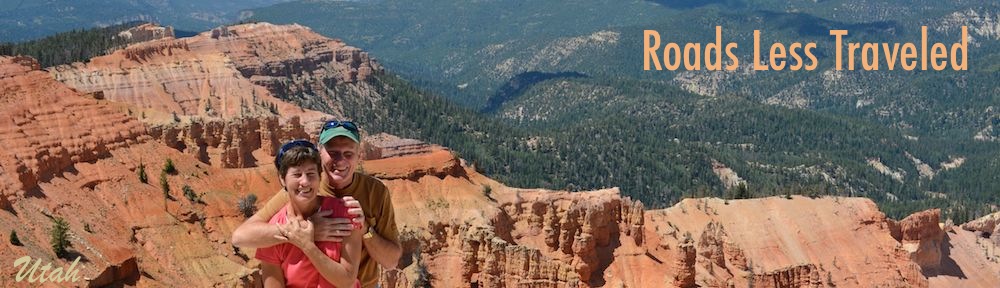
Capitol Reef National Park & Fruita, Utah
Mid-June, 2012 - After our energetic hikes in Natural Bridges National
Monument and our awe-inspiring drive along the Bicentennial Highway
(Route 95), we were geared up to for more immersion in Utah's red rocks.
We found exactly that at Capitol Reef National Park in Utah.
On our first afternoon
in the area we visited
Sunset Point, a perfect
spot to watch the sun
fall lower and lower in
the sky. The vivid
colors came to life in
the late afternoon.
It is a dramatic
setting - a
wonderful place
to get a photo of a
loved one with a
soaring backdrop.
There were clouds
in the sky, and
they wafted past
us overhead,
casting shadows
and playing with
the sunlight as
they passed.
Dead tree stumps were twisted into exotic shapes here and
there, looking a bit like driftwood that had been washed ashore
somehow in this burnt orange desert land.
Park benches invited us to take
a load off, but we were way too
busy running up and down the
hiking trails -- trying to see
everything at once -- to even
think about sitting down.
Off in the distance a
new wildfire smoldered. A nearby plaque stated that this part
of Utah boasts some of the cleanest air in the continental US,
but the smattering of wildfires that were burning at the time
weren't helping that claim.
We wandered among the red rocks until the disappearing
sun had quietly stolen all their colors away.
Capitol Reef National Park is a
long skinny park (~5 miles wide
by ~50 miles long) that runs on a
north-south axis along the
Waterpocket Fold which is a
huge buckle in the earth's crust.
There are loads of backcountry
roads and trails leading to wild
and remote places, but on this
visit we stuck to the easy-to-
reach hikes.
The tiny community of Fruita is at the heart of this area, and Mormons settled there in the late
1800's. By 1917 they had a bustling village filled with orchards. Cherries, apricots, peaches,
pears and apples are still grown here, but we were just a little too early to take advantage of any of the harvests.
Remnants of Fruita's past still remain
along the edges of the scenic drive
through the park. An old plow and a
pioneer schoolhouse were reminders of
a bygone era.
This area was extremely difficult to
reach for those pioneers, due to the
rugged terrain of the Waterpocket Fold,
but a route coming in did exist along the
bottom of a wash through Capitol
Gorge. Between 1871 and the early
1940's Mormons arrived via this route,
first by horse and buggy and then by
car. Looking at my photos afterwards I
noticed that Mark had been standing
pretty close to the spot where a photo
from the National Park Service showed
an antique car going through.
It took a group of men eight days to move all the boulders out of a 3.5 mile
stretch of the Capitol Gorge wash so it could be traversed by vehicles. Then two
cars could just barely pass side by side. Today the wash is regaining its natural
state and there are boulders and thickets of plants growing where it once must
have been smooth enough for a car to make it through.
As the arriving pioneers passed the towering cliffs, a lot of them stopped to
carve their names in the flat parts of the stone walls. Today it's called the
Pioneer Register, and we saw names and dates from the late 1800's all the way
to 1942. It is hard to imagine what those determined, rugged and travel-weary
people must have felt as they passed through this gorge to a new life. Little kids
with grubby hands must have peered out the windows of the cars, while
flustered moms tried to keep all their kids in tow. I can't imagine the exhaustion
and exhilaration they must have felt. Yet the town where they were arriving
didn't even have the paved campground loops, the gift shop full of coffee table
books or the flush toilets that it does today.
In my excitement of spotting
a list of names high up on
one wall, I hastily took a
photo without looking
closely enough at what I
was shooting. I managed
to get all the names in the
list but cut off the date -- it
was September 24th 1910.
Still mulling over the
immense changes that
have taken place in the
world since the last signatures from the 1940's were pecked out on these
walls, we started up the initial ascents of the Golden
Throne hike. This hike took us to the tops of the rock
cliffs where we had magnificent views looking down on
the road far below.
Gnarled trees greeted us as we climbed higher and
higher, until finally -- and rather abruptly -- we came to a
sign that said "End of trail." Behind it was the trail's
namesake Golden Throne, a huge round yellow rock.
Making our way back along the park's
simply named "Scenic Drive," the late
afternoon light was playing with the
rocks again, a game of hide-and-seek
that involved brights and shadows
on the burgundy rocks.
A lone barn belonging to the historic
Gifford Homestead and a horse
munching the grass in the pasture
across the street spoke of the
immense peace of this place. The
trees rustle so softly and the birds
chirp so quietly. The bustle of the
campground and the arriving cars of
tourists seemed to suddenly hush,
as if everyone knew to act as if the
were in a library in honor of the calm
that resides here.
If the pioneers had a tortuous trip getting
here, once they arrived and got settled they
must have paused for a moment on many a
luscious afternoon and murmured "This is
God's country," because it is, even today.
We fell under the area's spell and decided to do one more hike
before moving on down the road. Hickman Bridge is a rock
bridge that is a cousin to the three bridges we had seen at
Natural Bridges National Monument. It is an easy hike in to see
it, but once there we found it hard to get it lined up in such a way
as to prove that it was indeed a bridge. The other rocks and cliffs
all crowd around it, like a city swarming around a man-made
bridge, and only when you get
underneath can you get it
framed against the sky.
Mark gave up trying to capture
it on camera and simply sat
across the way admiring it, legs
folded and very content.
As has been the theme for us
this season, the heat of summer
began to catch up with us and soon we were pushed a little further
north in Utah to Koosharem Reservoir and Fish Lake where the
fiery red rocks gave way to cool green mountains and seagulls
flying over the water.