


Florida in the upper left, Venezuela along the bottom.


Southern Mexico & Northern Central America
Our Travel Route: May 2007 - June 2012
SUMMARY
Starting in May, 2007, our travels have taken us to these places:
2007 - RV: New Mexico, California, Oregon, Washington, Canada, Wyoming, Utah, Nevada, Arizona
2008 - RV: Arizona, Florida, Mississippi, Kansas, Arizona, Utah, Nevada, California, Arizona
2009 - RV: California, Florida, Mississippi, Arkansas, Kansas, Arizona, California
Car/hotel: Michigan
RV: Idaho, Montana, Nevada, Arizona
Airplane/hotel: SE Caribbean
2010 - Sailboat: California, Mexico's Baja Pacific Coast
2011 - Sailboat: Mexico's Mainland Pacific Coast, Sea of Cortez
RV: Arizona, Utah, Arizona
Sailboat: Sea of Cortez, Mexico's Pacific Coast
2012 - Sailboat: Mexico's Pacific Coast + inland trips by bus
RV: Arizona, Colorado, Utah
A complete chronological listing of all our travels (with links) follows:
FIRST YEAR TRAVELS - Western
Loop and Southern Loop
In May, 2007, we left our just-leased home in
Phoenix, Arizona and picked up our new Lynx
travel trailer in Kemp, Texas outside of Dallas.
We arrived at Marshall's RV with everything we
needed for our new lifestyle packed into the back
of our truck. After staying near the dealership for
ten days, just to make sure all the systems
worked okay, we headed west. We traveled
between I-10 and I-40 on small country roads
through west Texas and New Mexico. We
arrived in Flagstaff, Arizona, and installed a solar
panel and finished some personal odds and ends,
wrapping up our old life in Phoenix.
We left Flagstaff in June, 2007 and went to
Mammoth Lakes, California where we enjoyed
snow-capped mountains and crystal clear lakes.
From there we went to Yosemite National Park via Tioga Pass on the eastern side, and then took the tiny roads out of the
mountains to the west, skirting Sacramento and landing at the California coast at Fort Bragg, 150 miles north of San Francisco. We
wandered north along the Oregon Coast in July, 2007, awestruck by the rugged beauty of the craggy cliffs and crashing surf. At the
top of Oregon we turned inland, following the Columbia River along the northern part of Oregon. Next, we ventured into southern
Washington, exploring the often-foggy coast and the steaming cauldron of Mt. St. Helens. Then we made our way up to northern
Washington, where we visited Olympic National Park and Mt. Rainier.
In August, 2007 we took a ferry from Port Angeles, Washington to Vancouver Island and spent most of the month on the southern
half of the island. At the end of our visit we spent several days in Victoria, BC, before boarding a ferry for Anacortes, Washington.
From there we traveled east along the North Cascades in Washington to northern Idaho. In September, 2007 we traveled further
east to visit Glacier National Park in Montana. Then we dropped south to Yellowstone National Park in Wyoming where we
enjoyed both the tamed wild animals and the hot springs and geysers. Just a little south of Yellowstone we spent a day touring the
incomparable mountain and lake scenery of Grand Teton National Park in Wyoming and then made our way east to Devil's Tower
in northeastern Wyoming.
At the end of September, 2007, we reached our turnaround point at Custer State Park in the Black Hills of South Dakota in the
southwest corner of the state. We could feel the chill of fall in the air. We headed west through Wyoming along I-80 and dropped
down into northern Utah, wandering from Flaming Gorge National Recreation Area over to Park City outside of Salt Lake City, Utah.
Caught in an early snow storm we quickly dropped south again to Green River, Utah, and the San Rafael Swell where we were awed
by the easy access to ancient petroglyphs and dinosaur tracks. We dipped down from there, in October, 2007, to Goblin Valley,
Utah and then to Zion National Park and Kodachrome Basin, all along the unbelievably scenic Route 12 which zig-zags across
Utah. Chased by cold weather, we went south to the outskirts of Las Vegas, Nevada, where we found the stunning Valley of Fire
State Park. Here we saw sunrises that looked like sunsets and cycled on an exquisite road through geological formations of every
shape and color. As the nights grew cold in November, 2007, we sought warmth at Death Valley National Park in California and
then cruised into southern Arizona in early December, 2007, where we made our first visit to Quartzsite, Arizona.
We had completed a loop tour of the western states, and we were pooped! We recovered completely during Christmas, 2007, visiting
with family in Phoenix before returning to Quartzsite, Arizona in January, 2008 for their big RV show. While freezing in howling
winds under grey skies, we kept looking at the weather map on the back page of USA Today and seeing that Florida was toasty
warm. It was time to leave. We made our way east through Texas the long way, skimming the Rio Grande and the Gulf Coast,
dashing across Louisiana, Mississippi and Alabama on I-10 and arriving in Florida in February, 2008. We spent three months in
Florida, criss-crossing northern Florida several times. We visited Daytona just in time to see the Daytona 200 motorcycle race and
Spring Break. Then we cruised along the southern and western coasts of Florida, swimming at beaches near Miami and
Sarasota as we looped around to the Florida panhandle.
At the end of April, 2007 we visited the Gulf coast town of Bay St. Louis, Mississippi, amazed at this town's enthusiastic revival
following Katrina. From there we traveled north to Natchez, Mississippi where the great river was cresting higher than it had since
the 1930's and the historic mansions told stories of a different culture in a different era. We drove along the Natchez Trace Parkway
north to Jackson, Mississippi, exploring ancient Indian mounds and cycling this unique commercial-traffic free road.
SECOND YEAR TRAVELS - Southwestern Loop, Florida Dash & Heartland Detour Back West
In May, 2008, we arrived in Chanute, Kansas, putting our sightseeing on hold for a month as we immersed ourselves in learning all
we could about NuWa fifth wheel trailers. After a lot of thought, we decided to take the plunge. We made a deal at the factory with
local dealer H&K Camper Sales to buy a new Hitchhiker fifth wheel trailer. We moved into the new trailer on May 20, 2008, the exact
same day that we had left Phoenix to begin this new fulltime RV lifestyle a year ago. Thrilled with our new purchase, we needed to
get it set up for solar battery charging, so we returned to Flagstaff, Arizona where we upgraded the solar system we had had on the
Lynx. We felt a little like we were repeating history--but with greater knowledge and sophistication: we stayed in the same
campground and had a similar (though more complex) solar installation project as we had had during the same time period one year
before. We had learned something important during this year of travel, however: to slow down. Taking a break from our solar
installation work on the buggy, we cycled and hiked through the sights of Sunset Crater National Monument.
In late June, 2008, we left Flagstaff, Arizona and went all the way around the Grand Canyon to its North Rim. We stayed for three
weeks in an idyllic setting about 18 miles from the Rim. From there we wandered north through Kanab, Utah and discovered one of
Utah's great animal sanctuaries. After hugging and petting many non-human friends, we continued north to Ruby's Inn and Bryce
Canyon where we spent a month in a bucolic setting. In a past visit in our former lives, we had squeezed the North Rim and Bryce
into a few days. We were really learning to sloooow waaaay down.
At the end of August, 2008, we wandering among the small communities that dot the mountainous and red rock strewn terrain of
southern Utah. We basked in the small town comfort of Kanab and Alton, meandering along their pretty streets on brilliant blue-sky
filled days. And we enjoyed the hometown fun of a three-day Labor Day county fair in Parowan, Utah. During September we
stopped in at Pioche, Nevada, a once bustling mining town might have been the wildest frontier town in the heyday of the wild west.
From there we revisited our former lives with a stopover at Interbike, the annual bicycle industry trade-show in Las Vegas. We
caught up on the latest bike gear and saw Lance Armstrong in a night-time cyclo-cross race (but forgot to bring our cameras, so
there's no proof!).
Sweltering in the 100 degree Vegas heat, we dashed across the California desert (hot hot hot!) to San Diego's Shelter Island and
Mission Bay where the cool breezes, bright sunshine and salt air seduced us into staying for the entire month of October, 2008.
Heading inland, we spent November in Yuma, Arizona, where we enjoyed the last warm days of 2008 before the start of winter.
We stayed in the Arizona Desert for most of December and January. In Quartzsite we installed a vent-free heater just as the first
freezing winter storm hit. This kept us warm through the holidays in Phoenix, til we hit the San Diego waterfront once again to attend
the sailboat show in January. We were reluctant to leave the unusually warm, sunny coast, but great friends, good times and the RV
show awaited us back in Quartzsite.
Ready for a change of pace, we made a mad dash across country, and spent six weeks on the quiet rivers and sugar-white sand
beaches that fringe the Florida Panhandle's emerald waters. State parks and seaside villages highlighted our visit and made our
photo journal spill onto two pages (Florida Panhandle 2). Heading north, we visited the Natchez Trace in Mississippi a second time
and made some enjoyable stops in central and northern Arkansas. Warranty work on our trailer took us to Chanute, Kansas next,
followed by a long slog back along I-40 to Arizona.
We stopped at Roosevelt Lake in Arizona and had two blissful weeks of cycling, kayaking and photography. Spurred by a desire to
expand our travels onto the seven seas, we went boat shopping around San Francisco & Los Angeles.
THIRD YEAR TRAVELS - IN AND OUT OF THE TRAILER:
Midwest (by car/hotel), West (in trailer), SE Caribbean (by hotel) & Mexico (by sailboat)
An accident in May, 2009 put us in Michigan for seven weeks with friends and family but without our trailer. We looped around Lake
St. Clair, which borders both Detroit and Canada, and then dropped down to N. Ohio & Elkhart, Indiana where we visited the RV/MH
Hall of Fame and toured Amish Country and the Heartland RV factory. Later in June, we traveled up Michigan's west coast,
stopping in the charming waterfront town of South Haven. Continuing north, we traveled along the scenic coastal roads of Lake
Michigan (with a detour through Detroit) to hit Saugatuck, Higgins Lake and Traverse City, alternating between seeing new sights
and having Mark take me on nostalgic trips down memory lane. We continued north along the Lake Michigan coast, visiting the
harborfront villages of Charlevoix and Harbor Springs and driving under the unique green limbed canopy of the Tunnel of Trees.
In late June we crossed the Macinaw Bridge into the Upper Peninsula and visited the towns of St. Ignace and Hessel, making a brief
stop at the Great Lakes Boat Building School. A trip to the Soo Locks revealed both north and southbound freighters in the locks
simultaneously, one going up and one going down. We ended our Michigan visit with a trip down the Lake Huron shoreline,
marveling at lighthouses, shipwrecks and hydroplane boat races, and finally wrapping it all up with a stroll through the German
immigrant town of Frankenmuth.
We flew back to California and moved back into our trailer just in time for San Diego's 4th of July bash. Taking the long route north
and east, we traveled to Ketchum, Idaho, where we unwound in bliss and rediscovered our inner joy for a month. We worked our
way down much of the Visitors Center's 50 Fun Free Things To Do in Ketchum/Sun Valley list. There was the symphony's free
summer concert series, the Sun Valley Lodge itself, and winter sports memorabilia all over Sun Valley, ID. A little further north we
stopped in Stanley, ID, enjoying several blissful kayak rides in the crystal clear lakes among the mountains. We got a lesson in
salmon lifecycles too. As August, 2009 ended, our lessons shifted from fish biology to cattle ranching in Stevensville, MT (just south
of Missoula) at our good friends' neighbor's ranch. They took us to the annual Labor Day Weekend Hemville Rodeo to see how
ranchers unwind on the weekend. This event was so much fun we had to create a second Rodeo page.
In September, 2009, we hustled south along I-15, stopping several times between Logan and Cedar City, Utah to take in the sights
and drive the scenic roads through the mountains. A stint in Las Vegas, Nevada split us up between the glitzy annual Interbike
bicycle industry trade show and the soaring peaks at Red Rock Canyon. A brief detour along I-15 finally landed us at Valley of Fire
State Park for a second visit (first was in 2007). Red rocks, petroglyphs, jaw-dropping drives and exhilerating bike rides. A little
further down the Colorado River, we stopped at Laughlin, Nevada where the RV snowbirds were flocking on their flight south. By
the end of October we were back in Arizona for a free stay at Havasu Springs Resort in exchange for listening to an RV
membership program presentation. We returned to our home front, Phoenix, Arizona in November, 2009, and visited two Phoenix
Looking for new excitement and warmer climes, we jetted to Grenada in the southeastern Caribbean to begin a 10-week tropical
adventure. Going aboard a 75' wooden yacht that Frank Sinatra used to sail on was one of many highlights as we stayed on
Grenada's main island. Paradise Beach on Carriacou Island captivated us, and we enjoyed several walking adventures. We spent
many days in total relaxation and pure joy in Carriacou, Grenada, and eventually took the ferry to Union Island in the country of St.
Vincent & The Grenadines where Christmas Eve and Christmas Day celebrations were in colorful full swing. Next day, a 15 minute
flight landed us on the island of Bequia, at one time a charming oasis of peace and tranquility where we planned to spend a month.
Accosted by scam artists at the airport and finding the locals both sullen and mean, we searched hard to find the pretty side of this
island.
Meanwhile, an online search had turned up our dream boat for sale at a rock bottom price in San Diego. We submitted an online bid
as a lark and suddenly found ourselves thrust into the boat buying process once again. A wild 33 hour walk/ferry/taxi/jet ride to San
Diego put us face to face with Groovy, our new home. After two weeks of non-stop preparations, on January 31, 2010 we left San
Diego and went south to Ensenada, Mexico via ports at Puerto La Salina and Hotel Coral & Marina. We lived on our new boat
Groovy at Hotel Coral & Marina in Ensenada, Mexico for the next six months.
Getting out and about in Ensenada, we found small thrills in the markets and in "Gringo Gulch," the tourist zone. Over Valentine's
weekend we got downtown to witness the amazing spectacle of the Carnaval Parade. Returning to the US a few times we learned a
little about the border and were grateful at last to return home to the boat in Ensenada. Despite an El Nino year, a tsunami and an
earthquake, life in Ensenada was very sweet. In April, 2010, we watched two races back to back: the Rosarito-Ensenada bike race
and the Newport-Ensenada sailboat race. Settling back into our routine, we continued to prepare the boat for cruising and
discovered some colorful neighborhoods in Ensenada.
FOURTH YEAR TRAVELS - Ensenada Mexico, San Diego & Mexican coastline (by sailboat)
As May, 2010 ended, we continued exploring the area around Ensenada, Mexico, including La Bufadora, the famed blow hole. In
back-to-back contrasting adventures, we experienced both the genteel and the raucous at the Riviera Cultural Center and Baja 500
off-road race. Sticking to the genteel, we took a daytrip a few miles inland to experience the flavor and beauty of Ensenada's wine
country. Back at Marina Coral we met many interesting travelers passing through Ensenada, and we discovered a vibrant running
and racing scene in town. In early August, 2010, we moved Groovy to Ensenada's Baja Naval boatyard for a few projects that were
beyond our skill set, and said farewell to Ensenada.
Towards the end of August, 2010, we sailed up to San Diego and enjoyed the free anchorages that are available to cruisers there,
learning how to boondock on the water. In September we continued visiting the various anchorages around the bay as our many
projects to prepare the boat for cruising kept us in the San Diego.
In addition to the above map, there is more geographical detail on coastal Mexico here: Mexico Maps.
Finishing our major outfitting projects on Groovy in October, 2010, we started sailing down the Baja coast on November 2nd.
Harbor hopping a little and doing a few overnight trips, we continued along the Baja coast further until dawn of November 19th when
we motored past the gorgeous cliffside properties on approach to Cabo San Lucas. Following a brief stay there, we tackled 330
miles of open ocean to cross the Sea of Cortez to Chamela Bay on Mexico's mainland Pacific coast, called the "Costa Algre" ("Happy
Coast") for Thanksgiving. 55 miles further south, we were charmed by Manzanillo. "THIS is why we went cruising," we agreed,
remaining anchored off Manzanillo's Las Hadas Resort for 10 days. New friends persuaded us to keep moving south another 180
miles, taking us first to mini island paradise Isla Ixtapa where we swam and snorkeled and enjoyed the tropical air, and then on to
charming Zihuatanejo for Christmas and New Year's.
We stayed in Zihuatanejo for most of January, 2011, finding ever more enchantments in its nooks and crannies. At last we hauled
anchor and motored 200 miles back north to Manzanillo where we met my mom and took her to visit lovely Santiago Bay. We
hovered between Santiago and neighboring Las Hadas resort for a few weeks, enjoying a wide variety of scenery and activities.
Wandering just a little north for Valentine's Day, we discovered the unique charm of Barra de Navidad, an enclosed, serene lagoon
anchorage. From Cuastecomate to Tenacatita, once considered paradise, we experienced the human and ecological challenges
facing this area. A tsunami caused by a record earthquake in Japan sent us out to sea and up the coast where we discovered a
hidden island paradise among the islands in Chamela Bay.
At the end of March, 2011, we left the "gold coast" anchorages of the Costa Alegre, rounded Cabo Corrientes to the north, and found
ourselves immersed in the sailing and gringo oriented town of La Cruz de Huanacaxtle outside Puerto Vallarta. Further north we
visited the famed bells of San Blas and Isla Isabel's frigate bird colony and blue footed boobies. An overnight passage took us to
Mazatlan where we found a city in turmoil. So we quickly hustled across the Sea of Cortez on another overnight passage to the
bottom of the Baja peninsula. La Paz & Puerto Balandra were total delights in mid-April where we got caught up with provisioning
and learned firsthand about the potentially horrifying springtime Coromuel winds that haunt the area.
At the end of April, 2011, we started heading north into the Sea of Cortez, stopping at Isla Partida's Ensenada Grande and Isla San
Francisco. A late season (May) Norther packed a wallop, but we emerged unscathed in the gorgeous, friendly bay of Agua Verde.
Just a few miles up the coast we witnessed both the natural side and the resort side of the Sea of Cortez at Isla Coronado and
Ensenada Blanca, set against the backdrop of reading Steinbeck's Log of the Sea of Cortez.
FIFTH YEAR TRAVELS - Sea of Cortez (boat), US Southwest (RV), Sea of Cortez again (boat),
Mexico's Pacific Mainland (boat) and inland (bus/hotel)
On May 22, 2011, we toasted the end of our fourth year of travel and beginning of our fifth while anchored off Loreto, a pretty, laid
back town. We stayed in the Loreto area for several weeks, enjoying the civilized pleasures of Puerto Escondido as well as Loreto,
and then we ventured north to San Juanico and Bahía Concepción where we immersed ourselves in nature and hung out with the
local ex-pats. At the end of June, 2011, we left the boat in San Carlos Marina in Mexico and went to Phoenix to catch up on a long
list of chores and re-lease our townhouse.
In August, 2011 we jumped in the fifth wheel and went to Bonito Campground / Wupatki Nat'l Monument in Flagstaff, Arizona. We
explored caves, marveled at 2,000 year old pine trees and hiked red rock canyons in Dixie National Forest, Utah. Seeking more
red rock vistas, we did two hikes at another hidden jewel, Cedar Breaks National Monument where we were surprised by the
abundance of colorful wildflowers. Still not saturated with red rocks, we hiked all over Red Canyon and visited nearby Panguitch and
Tropic for some Mormon pioneer history lessons. We ended our RVing season with a county fair in Parowan, Utah, the Interbike
bicycle trade show in Las Vegas and some Route 66 nostalgia and discovery of Sycamore Canyon in Williams, Arizona.
We returned to Groovy in San Carlos, Mexico in early October, 2011. After crossing to the Baja side of the Sea of Cortez, we
stopped in at Punta Chivato and Bahía Concepción, where we found a cool wilderness school and met Geary the Cruisers'
Weatherman. Continuing south to the Loreto area, we swam and snorkeled in pretty La Ramada Cove and Isla Coronado before
seeing civilization again at Loreto and Puerto Escondido. Further south, the island anchorages near La Paz reveal a tiny
community, a long distance avian traveler, surprise treasure under water, and tropical beauty. The La Paz area gave us great tacos
and the La Paz Waltz, while nearby Playa Bonanza and Bahía Falsa soothed our souls. At the beginning of December, 2011 we
crossed the Sea of Cortez to La Cruz and then Paradise Village Resort Marina in Puerto Vallarta where we luxuriated in the
gorgeous resort surroundings. Swinging through Manzanillo Bay we were entertained by a whale, reconnected with old
acquaintances and made some incredible new ones. Christmas on Las Gatas beach followed by a tour of the could-be haunted
"Parthenon" of Arturo Durazo in Zihuatanejo wrapped up a fantastic 2011.
We started 2012 in the beautiful, warm and friendly Zihuatanejo/Ixtapa area. Heading south, we found high end yacht races,
soaring cliff divers, a fancy yacht club and several pretty anchorages in Acapulco. After the frightening discovery of a corpse at sea,
we arrived in the lovely Bahías de Huatulco at the end of January ready to soak up their natural beauty. In Huatulco's two little
towns we met some young Zapotecs and out of town we explored an Eco-Archaeology Park. Taking a bus over the mountains in
mid-February, we fell in love with the cool colonial city of Oaxaca. We found all kinds of color and action at Oaxaca's Zócalo and
were thrilled to witness a wedding in the Cathedral. Just outside town we discovered Zapotec pyramid ruins at Monte Alban and
wonderful relics at Oaxaca's Cultural Center. We took a daytrip tour to see the world's widest tree, learn traditional weaving
techniques, admire petrified waterfalls, marvel at ancient ruins at Mitla and taste some mezcals.
In late February, 2012, we crossed the Gulf of Tehantepec and stopped at the brand new Marina Chiapas next to the Guatemala
border. Taking the bus to Antigua, Guatemala we found a tourism-driven city that has an pretty veneer but a bullied soul. After a
few days back in Puerto Chiapas, we drove inland through the Mexican state of Chiapas on another unforgettable 200 mile bus ride.
In early March we took intensive Spanish classes in San Cristóbal and walked the pretty colonial streets. Five hours up the road on
a gorgeous mountain bus ride we stopped in Palenque where we saw amazing Mayan ruins and heard scary jungle sounds.
Narrow, bumpy roads and a boat ride up a river took us to the exotic, inspiring ruins of Yaxchilán & Bonampak. We said goodbye to
the Mayan world by visiting the gorgeous waterfalls of Misol-Ha & Agua Azul and celebrating the Spring Equinox at the Tenem
Puente ruins. In April, 2012 we left Groovy in Marina Chiapas for the summer and flew hurriedly to Michigan to see Mark's suddenly
ailing parents.
SIXTH YEAR TRAVELS - US Southwest (RV)
In May, 2012, we began our summer RVing travels with visits to Arizona's Mogollon Rim & Petrified Forest National Park.
Heading into Indian Country we visited Window Rock and stunning Canyon de Chelly National Park. Seeking a little more ancient
Indian exploration, we visited Mesa Verde National Park in Colorado and followed that up with some special encounters with the
locals in nearby Blanding, Utah. Following Utah's spectacular Bicentennial Highway, we visited Natural Bridges National
Monument. Turning west on Scenic Route 12 we arrived at Capitol Reef National Park where we immersed ourselves in red rock
vistas and pioneer history. Leaving red rocks for green rolling hills, Fish Lake, UT took us into the rural Utah countryside where we
heard the funny story behind Five Wives Vodka. With scenic drives as our theme, we continued north along the Provo Canyon
Scenic Byway and Alpine Loop Scenic Byway, home of Sundance Resort.
The following posts came after our transition to WordPress in the summer of 2012:
- Mirror Lake Scenic Byway Utah – Fishing and Fun!
- Bear Lake, UT – The Caribbean of the Rockies
- Afton, Wyoming – Cowgirl Town!
- Mesa Falls Scenic Byway, ID – Pretty Waterfalls
- Bitterroot Valley, MT – Traditional Roots in the Modern Age
- A Craftsman’s Dream Fulfilled: BitterSweet Guitars in the Bitterroot, MT
- Darby, MT – Fun Surprises in the Bitterroot Valley
- Big Hole, MT – Picture Postcard Perfect
- Dillon, MT – Sculpture, History and Hot Rods!
- Virginia City, MT – Living History in a Ghost Town
- Nevada City, MT – Rebuilding History in a Vanished Ghost Town
- Ennis, MT & Earthquake Lake – Small Town Charm & Airstream Trailers!
- Jackson, WY – The Wild West Tamed & Gentrified
- Pinedale, WY – A beautiful modern-day Boomtown
- Flaming Gorge, WY – Absolutely spectacular, colorful views and friendly big-game animals
- Flaming Gorge Utah – Fiery canyons, a cool river, and nearly tame bighorn sheep
- Vernal, UT – Colorful Gateway to Dinosaur National Monument
- Dinosaur National Monument, UT – More than fossilized dinosaur bones!
- Colorado National Monument & Fruita CO – Red Rocks, Cycling & Wine!
- Ridgway, CO – Peak fall foliage on the Dallas Divide – WOW!!
- Colorado GOLD – A Fall Foliage Photography Workshop
- Bisti Badlands NM – Mysterious rocks and an alien egg factory!
- Marina Chiapas in Puerto Madero (Puerto Chiapas) Mexico – Sailing near Guatemala
- Gulf of Tehuantepec, Mexico – Squeezing in a crossing between blows
- Huatulco’s Tangolunda Bay – Anchored inside a ring of luxurious tropical resorts!
- Huatulco’s Marina Chahué – Landlubbing with parrots!
- Huatulco’s Hagia Sofia (1) – Exotic fruits and tropical flowers in a lush garden oasis
- Huatulco’s Hagia Sofia (2) – Hammocks, hills, waterfalls and a Oaxacan feast
- Huatulco’s Santa Cruz Bay – great beaches & a cute harbor village – Paradise!
- Huatulco’s Las Palmas Resort – 24 Hours in Heaven!
- Huatulco’s Playa La Bocana – A visit to Huatulco’s Wild Side
An Overview of Our First 10 Years of Full-time Travel + Reflections after 9 Years!
- 10 Years of RVing and Sailing Full-time - The Early Years! - Running away in an RV, then broadening our horizons on a sailboat.
- 10 Years of Living on the Road - 2nd Half! - Fulfilling all our cruising dreams and then returning to full-time RVing!
- 9th Anniversary of RVing and Sailing Full-time - Reflections on how we started and what the first few months were like.
- 2007-2012 - Years of Discovery and Exploration by RV and Sailboat - WOW! We're FREE!
- 2013 - A Year of Transition: Goodbye Groovy, Hello Buggy! - Our last year in Mexico on our sailboat
- 2014 - A Year of Beauty in our RV - Back to full-time RVing...What a rush!
- 2015 - A Thrilling RV Journey East - From Arizona to Florida to Nova Scotia and back!
- 2016 - A Year of RVing the National Parks in America and Canada - Park to Park to the Canadian Rockies. SPECTACULAR!
- 2017 - RVing the West + Flying to Thailand, Cambodia & Paris! - What a fulfilling whirlwind!
- 2018 - The Year of the Dog! - Buddy turned our lives upside down and stole our hearts!
Subscribe
Never miss a post — it’s free!
Our most recent posts:
- Buckskin Mountain State Park – Fun on the Colorado River! 01/31/26
- How to Install Starlink Gen 3 in an RV? Use the Speedmount! 08/07/25
- Escape to Paradise – Rocky Mountain Magic! 08/01/25
- Is Forest River a Good RV? Well Built? Here’s Our Experience 06/20/25
- Sunset Crater Nat’l Monument – Lava & Camels at Bonito CG! 06/06/25
More of our Latest Posts are in the top MENU above.
Mesa Verde National Park, CO – Life on the Edge with the Ancients

Unusual rock formations line the road.

A deer says "hello" at Mesa Verde.

The Tower House, Mesa Verde Nat'l Park

Stone masonry from sandstone bricks.

They were as good at round walls as straight ones.

Communities are tucked under overhanging cliff walls.

Looking closer in.

Above the cliffs is flat land -- some has
been burned by wildfires.

A closer look at the buildings below.

Split-level living with some buildings on a higher ledge
and others on a lower one.

Cliff Palace.

A closer look at Cliff Palace.

A tour group walks through the Cliff Palace ruins.

An above-ground structure at Sun Temple.


The Far View Sites.

Don't Touch!!!

No climbing -- unless you're a
ranger.


Landscapes as we leave Colorado and enter Utah.

The real deal.

Winter wheat at twilight.

An old truck out back behind Jack's shop.

What else to do while waiting for work
on the trailer - take photos!

The round plastic handle was becoming square.


The design.

Jack and the finished product.

How it works and what it does.

Ta da!!

The Bicentennial Highway, Route 95 in Utah.

Typical sights along the "Bicentennial Highway"

Scenic Route 95.

"Oh oh oh oh -- it's perfect!!"


View out the window.

No one for five miles in any direction.

Why we love RVing in Utah.
Mesa Verde National Park & Eastern Utah.
Early June, 2012 - The mysterious cliff dwellings of Canyon de Chelly
National Park in Arizona had inspired us, so now we pointed our buggy
in the direction of Colorado's Mesa Verde National Park where another
massive cluster of cave homes lines the canyon walls.
We passed many
dramatic rock
formations on our
way, and we were
greeted by a deer
when we first
entered the park.
Mesa Verde is a vast park that requires a lot of driving on hilly twisty roads to
see all the sights. We were surprised by the huge number of tourists crammed
into the Visitors Center, especially compared to the quiet and laid back nature
of Canyon de Chelly. This is a park where you could easily stay a week or
more. The place is packed with different cliff dwelling structures as well as
above-ground ancient Indian ruins.
We tried to get our bearings quickly and headed out to the
Square Tower house. After driving some 10 miles or so
through the park winding along hill crests on curvy roads, it
was quite a surprise to walk down a short trail, turn a
corner, and find ourselves staring down at a beautiful intact
ruin.
The little community stood tightly pressed against a back-sweeping cliff
wall. The tower building was four stories tall with a large window on each
floor. But it all looked like a miniature doll house compound down there, far below our feet.
The buildings are made of sandstone bricks, each one about the size of a
loaf of bread, and they are mortared with a mixture of dirt and water. The
Ancestral Puebloans - or Anasazi - built these structures around 1100 to
1300 AD, but sadly left no written documentation behind.
At the Mayan ruins of southern Mexico we had been shocked to discover
that entire dynastic histories are known in detail today, right down to kings'
birthdays, city-state conquests and squabbles for power. However, at
these Indian ruins in Colorado we learned that very little is known with
certainty about the people who built and lived in them.
As we wound along the tops of the canyon walls, we were amazed to look
out across the narrow ditch and see all the tiny dwellings tucked into the
opposite canyon wall. At first all we could see was the faces of the cliffs,
but as our eyes adjusted to spotting the cave homes across the way,
suddenly they become obvious in every nook and cranny.
The park offers inexpensive tours of most of the ruins, but we contented ourselves
with getting an overview of it all from the top rather than climbing down in.
When we finally reached the Sun Temple overlook, the best place
to view the magnificent Cliff Palace ruins, we were amazed by the
complexity and density of the buildings. It was a complete town
nestled into a cave midway up a rock wall.
A tour group was passing through the ruin, and the tiny, brightly
colored people walking among the buildings gave us an interesting
perspective on this place. This canyon and its massive rock
formations is immense and timeless. But the people who built their
homes here stayed for just a few generations and filed through this
ageless place rather quickly. Fortunately for us today, they left a
most unusual signature behind: uneven, jam-packed housing.
We learned that the
first people to settle
this region were the
Basketmakers who wove very fine
basketry and built pole-and-adobe
houses above ground starting
around 750 AD. By 1,000 AD, just
before the Norman conquests of
England, they began building their
homes using stone masonry.
Interestingly, archaeologists say
their basketmaking skills showed
a marked decline once they
began to specialize in masonry.
It's intriguing to me that one skill rose while another
fell. And isn't it still so true today. We are all expert
at moving over ground at 60 mph but most of us
would balk at killing, plucking and carving up a
chicken for dinner, something our great-
grandparentss happily did years ago. We have all
become so adroit with electronic and keyboard
technology, but gosh darn if we aren't all forgetting
how to spell.
We wandered among the above-ground dwellings
and hiked around the Sun Temple and Megalithic
house. Like the Mayans at Bonampak who had
created an elaborate series of murals inside one
of their ruins but abandoned the building before
it was finished, here at Mesa Verde the Anasazi
had also abandoned their property before it was
totally completed. It is baffling to ponder how a
society can reach such heights of sophistication
and then vanish.
Unlike the Mayan ruins, however, where today's
visitors can scamper all over every building at
will, we saw signs posted everywhere telling us
not to touch or climb on anything.
Rangers, of course, are excepted…
Somewhere in our meanderings through Mesa
Verde we realized that we had reached total saturation with seeing the ancient
dwellings of antique cultures. We had seen some of the best of the best in the
last six months, and we were ready for a change of pace.
We left the Indians and Colorado behind and
crossed over into Utah, stopping at a gas station
to fill the truck. From somewhere in the distance
we heard the clank-clank-clank of spurs coming
towards us, and suddenly we found ourselves
face to face with a cowboy. Not a cowboy-hatted
urbanite donning the clothes and stance of his
country idol, but the real deal: a young,
hardworking cowboy who had just finished a dirty
week of cattle work.
When he started gassing up his truck, Mark struck up a conversation. It turned out he'd been
ranching all his life and now commuted every other week between Ogden at the north end of Utah
and Blanding a few hundred miles south at the other end of the state, to work on a ranch. He beamed
as he told us he had just found a house in the Blanding area so he could move his family down this
way. "Heidi is real happy," he drawled slowly, his bright blue eyes twinkling.
We asked him if our planned drive along Route 95 would be okay with our big truck and trailer (we
had read something about 8% grades). "Oh yeah," he said very slowly. "It's a real pretty drive.
That's how I go back and forth to Ogden." What a life: outdoors all day in some of the country's most
dramatic landscapes, and commuting to work on a National Scenic Highway.
Reassured that we would't be facing any gnarly
driving, we left the gas station and promptly
bottomed out the back end of the trailer on the
lip of the driveway. Our brand new bike rack that
we both just love scraped the pavement loudly
and the truck ground almost to a complete stop.
Mark made a face at me, and we leaped out of
the truck to check the damage. "We gotta fix
that!" He said nervously. But we were both
relieved that there was no damage worse than a few scratches. Our fantastic
new bike rack has been such a great addition to our travels this season, but it
hangs way out from the back of the trailer. This was the fourth time we'd
scraped it hard on the ground, and the once-round plastic knob on the back
was becoming rather square.
We drove over to the Visitors Center and found an old fellow deep in conversation with
the lady behind the desk. We asked if there was a good welder in town who could
fabricate something for a trailer hitch. They told us that JM Welding just on the edge of
town by the airport would do a great job for us.
Still uneasy about the Scenic Route 95 ahead of us that was known to
be so beautiful but scurried diagonally across the Utah map as if it
were a cat chasing a butterfly, I asked the pair if that route was okay
for a big truck and trailer. "Route 95?" the man said, "Why, I built that
road." Turns out that the construction of this road, known as the
Bicentennial Highway, had spanned from the 1930's to 1976 when it
finally got paved, and this man, Ferd Johnson, had been part of the
team that built it.
"We all lived out in the canyons for two and a half years while we built
that road." He said, telling us how rugged and wild and beautiful the
land was. "There are three bridges crossing the Colorado river, and
those were tough…" he trailed off. The lady behind the desk piped
up. "I did the drive once with him," she said nodding in his direction,
"and he talked the whole way. He had a story about
every mile of that road."
We left really excited to see this
scenic highway for ourselves. But our
first stop was at JM Welding. Jack,
the owner, understood exactly what
we wanted and said he could order
something like that and have it for us
tomorrow. "Or I can build one for you
right now that would be better quality
for about the same cost." Go for it!!
He grabbed a piece of chalk from his
pocket and drew an outline of a z-shaped
hitch extension on the shop's concrete
floor. Within moments his son had cut the
pieces and welded them. Jack powdered
coated it and cooked it for an hour while we chatted with Jed,
one of Jack's long-time customers who had just showed up.
"I'm really looking forward to driving that famous scenic Route
95 tomorrow," I said, making idle conversation. Jed looked at
me blankly. "Scenic road? There's a scenic road out
here?" I did a double-take. "You know, that Scenic Route
95. You take a right just a mile south of here…" He
scratched his head. "Oh, right…of course…oh yeah. I
drive that road all the time. It's pretty."
As we drove this magnificent road over the next two days,
our jaws dropping repeatedly at the stunning beauty around
us, we had to laugh. Utahans live in some of the most
spectacular scenery America has to offer, but I guess after
a while it becomes an ordinary backdrop for their lives.
In no time Jack had finished our hitch extension
and Mark mounted it on our trailer. Suddenly all
our fears of grinding our new bike rack into the
dust while boondocking down rough dirt roads
vanished.
Next morning, after a peaceful
night parked out behind Jack's
shop where fields of winter wheat
waved softly in the twilight and
dawn, we struck out on scenic
Route 95.
From red rock cliffs to exotic
pink-and-white striped swirling
rock formations to dramatic
descents into vivid green valleys,
we drove with our heads turning
constantly.
I literally hung
my whole
upper body out
the window a
few times to
snap photos at
55 mph.
The road swerved here and
there, curving deliciously
between cliffs and canyons.
Suddenly I saw a dirt road
scooting off to a wide flat
plateau. "Oh oh oh!!!" I
cried, not quite getting any
words out. "It's perfect!"
Mark skidded to a stop,
squeaked out a u-turn and
drove back. What a
sweetie!
Down the dirt road we went, bumping along to the most fabulous
and dramatic boondocking spot. There wasn't anyone around
us for at least five miles in any direction, and we had the
canyon, the cliffs and the sky to ourselves. That is the magic of
RVing in Utah. 50% of the state is public land, and you can
camp anywhere you dare to take your rig. It was so beautiful we
stayed for a few more days before exploring Natural Bridges
More blog posts from our RV trips to Colorado:
- Escape to Paradise – Rocky Mountain Magic!
- Sheep May Safely Graze (in the Mountains with Dogs!)
- Hartman Rocks – A Different View of Colorado near Gunnison
- Creede, CO – Mining History & Championships + 4th of July!
- Buena Vista Colorado – What a Place for an RV Breakdown!
- Rocky Mountain National Park & Trail Ridge Road: RV? Dog??
- Lake Granby Colorado RV Trip – A Summer Beach Vacation!
- Remote RV Camping: Antero Reservoir & Blue River Colorado
- Burro Days! Burro Races, Llamas & Outhouses in Fairplay CO
- Crested Butte – Wildflower Capital of Colorado!
- Silver Thread Scenic Byway in Colorado – Fire in the Sky!
- Telluride Gondola Ride in Colorado – FREE and Dog Friendly!
- Rocky Mountain High: Alpine Beauty in Colorado + Trout Lake!
- Where All News is Good News – At the Saguache Crescent in CO
- Lakes and Light in Wyoming and Colorado
- Colorado’s Stunning Scenic Drives…by Porsche!
- Cowboy Poetry Gatherings in Durango, Colorado, and Alpine, Texas!
- Black Canyon of the Gunnison National Park, CO – Steep and Deep!
- Romance at Maroon Bells Colorado!
- Colorado National Monument & Fruita CO – Red Rocks, Cycling & Wine!
- Mesa Verde National Park, CO – Life on the Edge with the Ancients
Our most recent posts:
- Buckskin Mountain State Park – Fun on the Colorado River!
- How to Install Starlink Gen 3 in an RV? Use the Speedmount!
- Escape to Paradise – Rocky Mountain Magic!
- Is Forest River a Good RV? Well Built? Here’s Our Experience
- Sunset Crater Nat’l Monument – Lava & Camels at Bonito CG!
More of our Latest Posts are in the MENU.
New to this site?
Visit RVers Start Here to find where we keep all the good stuff. Also check out our COOL NEW GEAR STORE!! *** CLICK HERE *** to see it!
Fish Lake Scenic Byway
 While visiting central Utah on a recent summer day, my husband and I drove the Fish Lake Scenic Byway, one of the state’s many beautiful highways and byways that are officially (and rightfully) designated as “scenic.” This road, Utah Route 25 between Loa and Fish Lake, weaves and curves through pine tree studded hills and into thick aspen groves. A bike trail runs alongside the lake and we quickly unloaded our bikes to ride this waterfront path. We soon found ourselves jumping on and off our bikes to take in the views, smell the fragrant air and check out the thick carpets of wildflowers that rolled down to the shore.
Fish Lake Lodge is the centerpiece of the Fish Lake community. It is a wonderful old building made of logs and filled inside with trophy heads, an inviting fireplace and a large dining room that looks out over the lake. We were there in summertime, but the fireplace looked like it would be perfect for snowy winter evenings too.
Of course the main activity at Fish Lake is fishing, and it seemed everyone we saw was car rying a fishing pole or a tackle box. A large family huddled around one of the fish cleaning stations near the Lodge, and two men busily carved up the day’s catch. The kids watched in fascination as one of the men sliced open the belly of a fish and then explained it was a female as he pulled out a fistful of eggs. The little girl scrunched up her face and squealed, “Gross!” while the boy next to her grinned, “That’s cool, Dad!”
The Fish Lake Scenic Drive lived up to its billing and each view around every bend was better than the last. The aspen shivered and shimmied their brilliant green leaves while the pointy dark green pines seemed to pierce the sky. First inhabited by mammoth hunters some 9,000 years ago, people have traveled through this area for a long time. A portion of the Old Spanish Trail, used by Utes and cowboys alike, wanders along the western side of the lake. Out of the corners of our eyes we both thought we spotted a train of horseback riders, but on second glance we saw it was a memorial sculpture in the middle of a field commemorating the Utes and settlers who traversed the Old Spanish Trail.
 Notes from Kit Carson in 1848 described the shallow streams in the area as “swarming with fish.” Using just “an old bayonet fastened to a stick” he caught five dozen fish at sunrise in the icy water one morning. We didn’t see quite such plentiful fish, but we found the flower-strewn banks of the lake and streams teeming with butterflies. The warm summer air buzzed with busy insects, and seagulls cried in the distance.
Trading our bikes and helmets for our hiking shoes and camera gear, we strolled along the shore, watching the cormorants fishing and seagulls soaring overhead. The sun glinted freely off the glittering lake and the sun was hot on our backs. In contrast to all the activity of the creatures around the lake, the campgrounds along the shore were quiet and had plenty of vacancies.
Our refreshing mid-summer’s trip to this bucolic spot reminded us yet again that Utah’s scenic byways are always worthy of a detour.
Natural Bridges National Monument & Utah’s Bicentennial Highway

At the top of Natural Bridges National Monument, Utah.

Some folks were put off by the
trail's wooden ladders.

Looking down is a bit unnerving!


The trail hugs a sheer canyon wall.

Barefoot tracks...


Dramatic cliffs and rock
formations everywhere


Full sized trees at the base of the cliffs.

Massive leaning walls are painted in vivid stripes.

Sipapu Bridge

Ladders...

…and carved stairs.


Striped cliff walls.

Kachina Bridge

Mark is dwarfed by Kachina Bridge.


Owachomo Bridge - delicate and soaring.

Owachomo Bridge.

The base of Owachomo Bridge.

"Bears Ears"

The Cheesebox.

Jacob's Chair.

Scenic Bicentennial Highway


Bridge over the Colorado.

Colorado River.


Scenic Overlook on the
Bicentennial Highway.

Ghost town Hite City lies underwater here.


The gods were messing with finger paints.

Scenic Route 24, Utah.

Capitol Reef National Park, Utah.

Capitol Reef National Park, Utah.
Natural Bridges and Utah's Bicentennial Highway
Early June, 2012 - After leaving Mesa Verde National Park we were
totally enthralled by the scenery that surrounded us on Utah's
Bicentennial Highway. This area is rich with exotic rock formations, and
three special ones are clustered at Natural Bridges National Monument.
While getting our hitch extension fabricated in Blanding we had learned
that our welder, Jack, had grown up playing among the bridge
formations before the modern park rules became so strict. "It was in
our backyard and we could camp anywhere in those days. I grew up
climbing all over those bridges."
Now it is a formal tourist attraction,
set aside and protected by the
government, with signs telling you all
the things you shouldn't do.
However, rather than having to scramble down scary drop-offs and wondering how the heck all
these formations got here, the National Park Service has built beautiful trails to the bridges and
offers all kinds of literature and books that explain everything about the geology, the wildlife, and
nature in general at their terrific visitors center.
Just like Canyon de Chelly where the canyons
are equally as stunning as the cliff dwellings, we
found the setting, the vistas and the hikes as
thrilling here as the bridges themselves. There
are only three natural rock bridges, but there is
an infinite number of spectacular views.
All together it's just four miles of hiking, but you
can skip doing your stair stepping workout on
the day you go. Each bridge hike is a nearly
vertical descent to the base of the bridge, and
then, after admiring it, you've gotta climb out. We quizzed
everyone we passed whether each hike was worth the
effort. Most said "Yes!" But one couple was put off by the
rickety looking wooden ladders. We found the ladders were
actually really fun! They're rock solid and shiny smooth
from thousands of hands and feet using them.
The trail to Sipapu bridge is
sandy and hugs a sheer canyon
wall. There are all kinds of
footprints from previous hikers,
but the ones that caught my eye
were the barefoot ones. I felt like
I was following an Indian. But it
was just someone wearing those
newfangled Vibram FiveFingers
shoes!
We scampered all over the place, soaking
up the towering cliffs and basking in the
silence. It is hard to imagine that the
immense natural force of flowing water
created these formations.
Many of the rocks are beautifully striped,
carefully painted in vibrant hues by
mother nature.
The size and scale was hard to
capture with the cameras,
especially trying to draw into the
lens that sensation of being
embraced by soaring cliffs and very
hot sun.
Mark got to the
Sipapu bridge
first, and when
he called back
to me his voice
echoed
wonderfully
between the
rocks. He let
out a few extra hoots
and whistles, enjoying
the effect. I hooted
and whistled back and
marveled at hearing
the sound perfectly
duplicated.
Climbing back out we noticed
how the Park Service has not
only installed fantastic Navajo
looking wooden ladders, but
has carefully sculpted out lots
of stairs in the rocks as well.
And we learned these bridges
were first found by Cass Hite in
1884 when he was searching for gold.
Kachina Bridge was up next, and
again we descended on a nearly
vertical path into a vibrant green
wash filled with trees and refreshingly
cool shade. The rocks here had
been painted in stripes too, and bird
songs echoed off the canyon walls as
they flitted from tree to tree.
We staggered around in the sandy wash at the base of the bridge, craning
our necks as we tried to take it all in. This bridge is thick and squat, and the
underside is decorated with scraggly petroglyphs. People have lived here
off-and-on for 9,000 years, including a few Mesa Verde cliff dwellers who
moved over here for a few generations around 1200 AD. This must have
been a great spot to while away the hottest summer hours back in the days
when air conditioning was unavailable and people entertained themselves
by pecking out images on rock walls.
The steep climbs and descents began to blend together in a
haze of sweaty huffing and puffing as we put one foot in front of
the other and hiked up and down the canyons.
The last bridge in the trio is
Owachomo Bridge. Where
Kachina Bridge had been thick
and massive, Owachomo was
thin and delicate.
Still mighty at its base, from a
distance the narrow stone
seemed almost wispy as it
soared across the expanse.
As we left Natural Bridges National
Monument we caught a glimpse of the
twin peaks the Indians called "Bears
Ears." What a perfect name!
Many rock formations, cliffs and mesas
around here often beg to be named
because their shapes are just so
familiar. The Bicentennial Highway
took us past the Cheesebox and
Jacob's Chair.
Back on the scenic Bicentennial Highway the views really got us excited as we
approached Glen Canyon and the Colorado River. I was practically jumping up
and down in my seat with excitement as the truck swept around one gorgeous
curve after another.
Mark just puttered along, patiently driving, while I whirled around from side to
side snapping hundreds of photos out the windows. I even climbed up to sit in
the truck window a few times to get pics over the roof. It is just that gorgeous!
This section of the road must have
been a huge challenge to construct,
and I kept thinking of Ferd Johnson
from the visitors center back in
Blanding who described living out in
these canyons for over two years
while building the highway and the
bridges across the river.
What a place to work!
We stopped at a scenic overlook after
crossing the river and learned that
when the river was dammed back in the
1960's, the new Lake Powell flooded
not only countless ancient Indian
settlements complete with artifacts,
petroglyphs and other priceless
treasures of humankind, but it flooded
an old mining ghost town as well. Hite
City had boomed when local miners got
"uranium on the cranium" and started
searching the area for "hot rocks." Now
the entire town lies underwater.
Back in Blanding, both our welder, Jack, and highway builder Ferd
told us they remembered this canyon vividly from the days before it
was filled with water. What an event it must have been when the
dam was completed to see the water rise against the cliffs and
transform the landscape.
Eventually the scenery along the Bicentennial Highway simmered
down to downright boring, and I settled down in my seat. From
Route 95 we turned west onto Route 24, and then the views began
to build yet again.
Swirling patterns filled
the rock landscape. It
seemed the gods had
gotten their hands
colorfully dirty, messing
around with finger
paints, and then had
smeared their prints
across the rocks.
We approached some
towering pale cliffs and
then found ourselves
deep in the heart of red
rock country.
We had arrived at Capitol Reef National Park. What a
spot! The bright green trees, burnt orange rocks and crisp
blue sky made a vivid feast for the eyes. We happily
agreed to settle in here and explore the area for a while.
Subscribe
Never miss a post — it’s free!
Other fabulous scenic drives in Utah:
- A Back Roads RV Trip – AZ to NV to UT – Colorado River & Spanish Trail
- The Burr Trail – A Fabulous Side Trip on Utah’s Scenic Byway 12
- Utah Scenic Byway 12 RV Trip – Driving An All American Road!
- Utah Scenic Byway 24 RV Trip – Capitol Reef National Park
Other wonderful hikes:
- Beehive Trail in Arizona – A “Mini Wave” hike by Lake Powell
- Bell Rock Pathway, Sedona AZ – Hiking & Biking the Red Rocks
- Brins Mesa Trail & Unexpected Delights in Sedona Arizona!
- Broken Arrow Trail in Sedona, AZ – What a Hike!
- Bryce Canyon National Park – Fairyland Trail – A Beautiful Hike!
- Cathedral Rock at Red Rock Crossing – Sedona AZ
- Cedar Breaks National Monument in Utah – Better Than Bryce?
- Goblin Valley State Park Utah – One Gigantic Playground!
- Grand Staircase Escalante Nat’l Monument – Lower Calf Creek Falls Hike
- Hiking the “Pig Trails” in Sedona, AZ – Breathtaking! (oink oink!)
- Paria Rimrocks “Toadstools” Hike to A Hidden Canyon!
- Red Canyon – Arches Trail – Windows & Hoodoos in Utah!
- Red Canyon Utah is an Overlooked Treasure
- Sedona – Mountain biking in the red rocks!
- Sedona Arizona – Brooding Skies at Sunset in the Red Rocks
- Sedona Reflections on the West Fork Trail
- The Crack at Wet Beaver Creek (Bell Trail Hike), Sedona, AZ
- Top Sedona AZ Hikes: Little Horse to Chicken Point + Templeton Trail (Cathedral Rock)!
- Wire Pass Trail – Slot Canyon Hiking!
Our most recent posts:
- Buckskin Mountain State Park – Fun on the Colorado River! 01/31/26
- How to Install Starlink Gen 3 in an RV? Use the Speedmount! 08/07/25
- Escape to Paradise – Rocky Mountain Magic! 08/01/25
- Is Forest River a Good RV? Well Built? Here’s Our Experience 06/20/25
- Sunset Crater Nat’l Monument – Lava & Camels at Bonito CG! 06/06/25
More of our Latest Posts are in the MENU.
New to this site?
Visit RVers Start Here to find where we keep all the good stuff. Also check out our COOL NEW GEAR STORE!! *** CLICK HERE *** to see it!
Petrified Forest NP and Mogollon Rim – Cool pines & hot rocks in AZ!

Getting to the US required 3 planes.


Bleeding Heart.

Saguaro cactus top in
bloom.

Starling chicks in a saguaro nest.

Mom takes good care of the babies in their fallen home.

A cardinal enjoys a
snack on our table.

The Mogollon Rim.

It's a little scary right at the edge, but
few can resist a shot.

Smoke from the Gladiator Fire approaches.

Wildfire smoke obscures the sun.

The awesome little paved rimside trail.

It's great to be alive.

Mogollon Rim.

Spring - a time for new growth.


An elk calf in the grass.

Woods Canyon Lake.

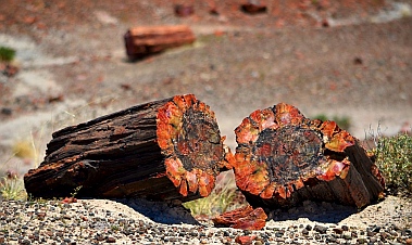
Jim Gray's Petrified Wood
Company.

Petrified logs ready for splitting.

Geodes ready for opening.

Dinosaur country!

They're cute, just don't get bit.


Petrified Forest National Park.

A tree trunk that has cracked into drums.

Agate House.

They built 'em small in 1200 AD

The National Park calls these rock structures "teepees."

Collared lizard on a petrified log.

Cows watch us approach.

Puerco Pueblo housed 1,200 people.

A stork carrying a baby, for sure!!

Santa Fe Railroad.


A rusting relic near the old Route 66.

Painted Desert.
Mogollon Rim & Petrified Forest National Park
April-May, 2012 - It took us a few days to decompress after our awe inspiring three
weeks in inland Chiapas. We had studied Spanish in colonial San Cristóbal, seen
Mayan ruins in Palenque, Yaxchilán and Bonampak, and visited sparkling waterfalls
at Agua Azul and Misol-Ha. But we had received alarming news while in the jungle
that Mark's parents had unexpectedly taken very ill. Their prognosis for survival had
become bleaker by the day.
We scrapped our plans to
sail 200 miles further to El
Salvador where a rollicking
annual rally of 50 boats was
in full swing, and instead
prepared our boat Groovy for a six month wait at Marina Chiapas while
we made a hasty retreat back to Mark's family homestead in Michigan.
It was jarring and disorienting to rejoin
modern American life after months of
immersion in southern Mexican culture.
Far more upsetting, however, was suddenly finding ourselves face-to-face with the specter of
death. We passionately pursue our dreams everyday, always feeling the immense pressure of
time, but now the grim reaper was at the door trying to collect. For days we huddled inside the
drab sterile walls of a modern health care facility trying to be positive while pondering the
incomprehensible.
Fortunately, spring was in full bloom outside. Flowers were bursting with
color everywhere, and flowering trees seemed to grace every front yard.
Every time we stepped outside we were greeted by the cheerful image
of tulips, a heartwarming flower neither of us had seen for years.
Very gradually, and totally miraculously, both of Mark's parents began to
recover and were able to return home. As they gained strength we did
too, and the dark, raw emotions in our hearts began to ease. Out in a
friend's garden a cluster of bleeding hearts reminded us that often the
most precious things in life are also the most fragile, and that life itself is
a gift we receive every day.
When we eventually returned to our own hometown in Phoenix, Arizona, we
found spring had sprung there too. Our beloved saguaro cactuses were
wearing their little springtime crowns of white flowers on every limb.
Just a few weeks earlier an ancient saguaro in a friend's
yard had died and toppled over. It now held the fledgling
chicks of a starling that had moved into her condo when
the cactus was still upright.
Despite living in a house that was now eight inches from the ground,
not a great spot for a small bird, she bravely got those chicks raised to
adolescence, and in no time they had all moved out.
We got our trailer out of storage, dusted it off, and set up camp at
nearby Roosevelt Lake. Still recovering from all that had gone on, and
feeling a bit battle weary, we reveled in watching a cardinal come to
our little seed plate every day. We could have stayed for a month, but unfortunately the desert temps
were climbing and soon became intolerable.
Fortunately, just 80 miles north of Phoenix we found ideal temps
up on the Mogollon Rim (pronounce "Mugeeyone"). At 7500'
we were in the cool pines, and we found a camping spot right on
the edge of the rim with views to the valley floor far below.
The rim is a jagged shelf of flat rocks that stick out in layers.
The views are expansive and the smell of the ponderosa pines
is invigorating. There is something about the edge of the rim
that is very alluring and draws people to it, even though the
sheer drop-off is a little unnerving. At all the scenic overlooks
everyone gets out of their cars and walks right out to the edge
to take in the view and get a photo.
While we were there four huge forest fires were
burning in the valley below us. The Gladiator Fire
made the national news, and we saw the hotshot
firefighting team's base camp nearby. Firefighters
had been flown in from all over the country to help
out, and some 1,000 people were fighting the
blaze. The smoke was intense
at one point, and it billowed
over us like a huge wave.
That evening the sun was
almost totally obscured by the
smoke. But the hotshots
managed to wrestle all the
fires under control, and in just
a few days the air was clear
again.
We discovered a wonderful
paved trail that runs along the
edge of the rim for a few miles.
Luckily for us, it had just been
lengthened by a mile. The edge of the rim
is magical, and at every rock outcropping
we found ourselves stopping to get another
look. This same trail also heads into the
forest towards Woods Canyon Lake where
it weaves past several campgrounds. We
rode our bikes along the trail and savored
the crisp air and pretty views.
Spring was happening up here too. The
pines were all adorned with their new
feathery soft needles, and we found flowers
that looked like wild irises growing in a
meadow.
We passed a mother elk
sitting under a tree
chewing her cud. Nearby
her young calf was
hanging out chewing its
cud too. They were
totally indifferent to our
presence -- or to that of
the cars that had started
to stack up in the road as
everyone grabbed their
cameras and jumped out
for photos. We stood
there for quite some time
watching the mouths of
these two large animals slowly working around and
around while their gazes wandered calmly between us
and the cars. It was as if they were kids hanging around
at the street corner, chewing gum, and waiting for
something to happen.
Woods Canyon Lake is cool and serene, surrounded
by pines. Families were out fishing and an energetic
guy rowed a skull back and forth.
We stayed in this beautiful mountain forest
for two weeks, settling into our homestead
as if it were our own private mountain home.
Every day we ran, biked and walked. Then
we read, napped, played on the internet and
watched the boob tube, something we hadn't
done for eight months. Isn't it amazing, we
kept saying to each other, that we can get 12
Phoenix digital TV stations via our antenna
and good internet from our nifty new Verizon
MiFi unit, while we are camped several miles
down a dirt road deep in the woods on the
edge of a cliff?!
It was hard to leave, but once we
got the wheels rolling on our
buggy, we couldn't wait to get out
and see our beautiful country. Our
first stop was the Petrified Forest
National Park. Actually, we
stopped just before the National
Park because the guy who owns
the vast acreage next door has
been mining petrified logs from as
deep as 30' down in the ground for
decades, and the collection he has
on display and for sale at his store
"Jim Gray's Petrified Wood Company" is astonishing.
Petrified logs are created when a log gets buried in sediment, preventing rot, and then becomes
infiltrated by silica in the groundwater, replacing its organic material. This stuff eventually
crystallizes and "petrifies" the whole log. Over time, as erosion peels the ground out from under
the log, it cracks into short drum-shaped pieces that for all the world look like they are ready for
splitting.
We wandered through the
endless display of petrified logs
and even found a pile of geodes
out back. This pile stood almost
10' tall and maybe 30' around at
the base. What a treasure trove!
This is also dinosaur country,
and the local gift shops have all
kinds of fun making crazy
displays for tourists. Mark found
a few out by the geodes.
Petrified Forest National Park is an easy park to miss
inadvertently because it sits on a road that cuts between an
Arizona highway and an interstate. We had made that mistake
years ago. We had driven along at 55 mph waiting to see a
Forest, and we skipped the pullouts because there was no
evidence there was any Forest there. After an hour we emerged
at the other end of the park having seen nothing but wide plains
and a few scattered logs in the distance. That goof-up has been
a standing joke between us ever since.
The only way to see this national park is to get out
and do some hikes. The hilly field behind the
visitors center is strewn with huge logs, many
resting in a row and fitting together to make an
entire tree trunk. These things are massively heavy
and are 8 times harder to cut than granite. From a
distance the crystalized bark, knots and tree rings
look lifelike, but up close the agate colors merge
and swirl in non-treelike patterns.
We hiked on the Long Logs trail which features one tree
trunk after another, each one segmented into shorter
logs that lie end-to-end. Looking around the sweeping,
empty, grassy plains it is hard to imagine that 260 million
years ago this area was a logjam in an ancient riverbed,
back when all the continents were joined and Arizona's
latitude was somewhere around modern day Panama.
13 species of large but extinct pines forested the area.
Out at the Agate House we
found an ancient Indian
pueblo made of petrified
wood pieces. Archaeologists
believe it was constructed
between 1050 and 1300 AD.
Those guys built very small
buildings.
The trail took us past tall,
horizontally striped "sand
piles" that are now solid
stone. It looked like a gravel
yard that had been carefully
layered in different types of gravel. The heights of the
dark stripes matched from one pile to the next. There is
an otherworldly quality to this landscape.
As we walked back to the
truck Mark spotted a collared
lizard sitting on a hunk of
petrified wood. His little pink
mouth seemed to be grinning,
and his long skinny tail trailed
almost twice his body length
behind him.
This is cattle ranching country
too, and before we could get
to the petrified log that spans a chasm -- the Agate Bridge -- we had to
get past a group of cows standing in the middle of the road. These
guys didn't move an inch as we drove past. Only their heads turned to
watch us as our enormous truck and trailer nearly brushed them when
we drove by.
The Puerco Pueblo hike took us to an ancient Indian settlement built
around 1250 AD. It was home to some 1,200 people. 6'x8' was a typical
room size, and unlike the mammoth Mayan and Zapotec buildings we'd
seen a few thousand miles to the south, these ruined walls have been
reconstructed to
just a foot in height.
Far more intriguing
for us were the
petroglyphs that the
ancients had
pecked into the nearby rocks. One showed what
looked to me like a stork carrying a baby. I'm sure
the archaeologists would disagree about that, but
these images are often a bit like ink blots -- what
you see in them is up to you.
The park road crosses I-40 and deposits visitors in
the middle of the Painted Desert. But first you get a glimpse of the
Santa Fe railroad and some relics of the old Route 66. While we
were wandering the hiking trails closest to I-40 we kept hearing
the horns and rumbles of endlessly long trains rolling past. I
climbed up on a bridge overlooking the tracks and caught a train
as it approached. Running to the other side I watched it
disappear around the bend. These tracks date back to 1882
when the Atlantic and Pacific Railroad went through. Early visitors
to the park arrived by train and took guided tours hosted by the
Fred Harvey company.
Mark was fascinated by an ancient rusting hulk of a car
that had been abandoned long ago on the side of the
old Route 66. Stretching 2,200 miles from Chicago to
Los Angeles, that historic road passed right through
this area, bringing tourists to the park in their own
private cars instead of by train. Now this part of Route
66 is overgrown by prairie grasses.
Our final miles along the park road
took us past some incredible vistas
overlooking the Painted Desert. This is
a colorful area of more gravel-pit
looking solid stone "sand piles," and
we had taken so long
getting through the park
that we arrived while the
late afternoon sun was
lighting the vivid
landscape to its most
brilliant hues. Gazing out
at this exotic land, the
sun beating down on us
and our sinuses rapidly
shriveling up in the dry air, it was hard to imagine what the ancients or the early
settlers must have thought or how they even survived. So harsh and yet so
beautiful.
By now our spirits were fully restored. As we studied our maps we decided to
head north via the tiny squiggle labeled "Indian Route 12" and head towards
Canyon de Chelly National Park. This road was marked as a scenic route
but despite being Arizona residents before our traveling lifestyle we had never
heard of it before.
Articles
Yaxchilan and Bonampak – Haunting Ruins & Ancient Art in the Jungle

Kim Tours starts our day with a big breakfast.

Cattle are hustled down the road.

Boats waiting to take tourists to the ruins upriver.


We all piled into our boat for an hour's journey
to Yaxchilán.


Our guide.

We spot Yaxchilán through
the trees.

Hiking up to the
"Little Acropolis."

The "Little Acropolis."

Entering "The Labyinth."

Light at last…!

We emerge in front of "The Labyrinth."

Green moss clings to everything.


Note the boxy hieroglyphs carved
in the lintel above the doorway.

Structure 33. When built by Bird Jaguar (who reigned
752-772 AD), this made quite a sight from the river.

Structure 20.


King Bird Jaguar IV plays ball amid symbolism and hieroglyphs about his rise to power.

King Bird Jaguar IV's mother,
Lady Eveningstar.


We're faster than that croc, aren't we?


Van ride for our leg into the Lacadón Forest.

Bonampak's main plaza.

Three doorways lead into three rooms of
matchless Mayan murals.

Room 1: Pomp and circumstance surround the presentation
of King Chan Muan II's infant heir.

The detail -- nearly 1200 years later
-- was astonishing.


Celebrating with trumpets.


Room 2: Prisoners are tortured by pulling out their fingernails.

Room 3: Noblewomen pierce their tongues in ritual blood-letting.

Lintel above Room 1's doorway: Chan
Muan holds a captive by the hair.

She got a kick out of taking a
photo of Mark.
Yaxchilán & Bonampak, Mexico
March, 2012 - There are many beautiful things to see in the Palenque area and, for most tourists, rather than struggling to
drive on the little winding roads, the easiest way to see them all is by van tour. Van tours are a big business in this region, and
almost all the vehicles on the small roads outside Palenque are vans filled with tourists. Our van from Kim Tours picked us up at
7:00 a.m. for a 12-hour tour to the remote Mayan ruins of Yaxchilán and Bonampak. After several hours on the road, everyone
in our group was grateful when the van stopped mid-morning for a sumptuous breakfast at a casual open-air restaurant.
Besides van tours, farming and agriculture play an important role
here too, and we watched with amusement as two cowboys on
horseback hustled a herd of cattle down the road while we were
getting back in the van after breakfast. Those cows could trot
pretty fast!
After another hour or so of negotiating skinny, speedbump filled
roads, we finally arrived at the river that defines the border
between Mexico and Guatemala, the Río Usumacinta. Here we
boarded a small outboard-driven boat with a canopy top for an
hour-long boat ride up the river. Talk about remote -- these ruins
are really out there!
We were five
couples all together.
Two couples hailed
from Mexico City
and Argentina, and
they gabbed away in
Spanish with each other
and the guide. The other
two couples were from
French Canada and
France, and they
chatted easily in
French. We mostly
listened and enjoyed
the views.
The narrow river
meandered between
thick jungle greenery along its banks. At long
last we spotted a tall pile of rocks between the
trees heralding our arrival at the ruined Mayan
city of Yaxchilán.
We climbed a steep, moist hillside trail and
suddenly found ourselves staring at the
familiar pyramid shape of a huge Mayan building, the "Little
Acropolis." This building was extensive and had rooms and
windows and unroofed hallways that begged to be explored.
However, we were given only an hour to see the whole sight
and the "Great Acropolis" complex of buildings awaited us
further on. If only you could go to a place like this easily on
your own and hang out for a few days...
Hiking back down and then up again,
we came to "The Labyrinth," a crazy
maze of winding tunnels that is pitch
dark inside. We relied on flashes
from our cameras to light the way.
Finally shafts of light penetrated and
we emerged on the other side,
standing in front of a series of doors
into the Labyrinth and looking out
into the Grand Plaza.
The jungle here has been
conquered, seeded with grass lawns, and swept back to reveal these
impressive ruins. But mossy overgrowth clings to everything. As we
wandered past sturdy walls and rows of doorways, two thoughts kept
swirling through my mind: what did this place look like when it was
newly constructed and filled with inhabitants? And what did the
European discoverers think when they first found this large complex of
buildings in the tight grip of the
jungle in the mid-1800's?
It is mind-boggling to think that this
little bend in a nondescript, brown
silty river was once a very important
spot, a destination, a port for trade.
Today it would be indistinguishable
from the rest of the jungle
riverbanks if it weren't for the
sprinkling of tourists
arriving every few
hours in colorful
canopied boats.
Who built this stuff
and when?
Fortunately, Yaxchilán is loaded with doorway and window
lintels that are covered with square-shaped Mayan
hieroglyphic text, and they tell the story. Unraveling the
meaning behind Mayan hieroglyphs began in the late
19th century, when the numeric system was first
deciphered. Major breakthroughs came in the 1980's
(while studying lists of rulers in Palenque), and now
90% of Mayan writings can be read. The history of
conquests, defeats and transfers of power in Yaxchilán
are surprisingly well known, right down to specific days
and years due to the detailed Mayan calendar.
The area was likely settled by 250 AD, but
the first historic text points to 359 AD when
Yaxchilán's first ruler ascended the thrown.
Rulers with evocative names like "Bird
Jaguar" and "Moon Skull" reigned for
centuries, each date of ascension to the
throne carefully recorded in stone. One
ruler's wife, Lady Pakal, lived to the ripe old
age of 98. That may not have been a typical
ancient Mayan lifespan, but the ruling class
obviously lived well.
The city reached its peak in the early 8th
century, and most of the ruins date from that
time period when the reigning king (who lived
into his nineties) went on a building spree.
The amazing thing at this site, besides the expansive
grounds filled with 120 or so ruined buildings, is the
detailed carvings on the lintels. Passing under a
doorway you look up and see the most beautiful and
intricately carved stone just overhead. The images are
clear, and archaeologists have sorted out what almost
all of them depict -- with the help of the descriptive boxy
hieroglyphs that accompany each one.
One relief shows King Bird Jaguar IV playing ball in the
ball court, a game that had deep mystical overtones in
Mayan culture. The text around the images makes reference to
both blood letting and the decapitation of three deities leading to
three "dawnings." Two dwarfs are marked with the signs of Venus.
It is thought that they figuratively sweep the path for this rising king
as Venus sweeps the path for the rising sun.
Now it helps to know a little background about this guy Bird Jaguar IV. He was not born
in direct line to the throne, being the son of the 2nd wife rather than the 1st wife of the
king. It seems his mother, Lady Eveningstar, was quite ambitious for her son, however,
and there might have been a power struggle after her husband's death. She may have
even ruled Yaxchilán temporarily while she waited for her boy to grow up and take
over. After nearly ten years her son was finally crowned King Bird Jaguar IV.
Another relief shows this woman, the ambitious Lady Eveningstar, dressed to the nines.
Yaxchilán and its neighbors alternated between being friends and enemies, making
alliances through marriage, and taking each other's kings captive by turns. Victory
seems to have rotated between the city-states for a while, but Yaxchilán seems to have
come out on top in the early 9th century AD before
the entire ancient Mayan world slipped away into the
grasp of the jungle (possibly due to deforestation and
overpopulation).
One of the nearby rivals was Bonampak, and
fortunately for us, its unique ruins were our next stop.
First, however, we had to take another river boat ride
back to the van. Waiting to see us off at the river's
edge was a very large, grinning crocodile. Our
boatman took us pretty close to this fellow so we
could get a good look, but he assured us our
outboard engine was
faster than the croc!
The ruined Mayan city of Bonampak is situated in the
Lacandón Jungle where a very special group of
indigenous people, the Lacandones, make their home,
deep in the rainforest. When the Spanish arrived in the
16th century, the Lacandón people retreated further
into the rainforest and were never discovered.
Although they had frequent contact with other Mayan-descended groups through the centuries, the rugged lands around them
helped them keep the world at bay, retain their identity and avoid the fate of most other indigenous groups for a long time.
Numbering just 650 or so native speaking Lacandón people today, it is only in the last fifty years that relentless logging,
ranching and tourism development have invaded their space and forced them to go through the conversions and changes that
the rest of Mexico underwent four hundred years ago. Besides learning Spanish, many converted to Christianity (mostly
Protestantism). Conversion was a change the men largely frowned upon because of its intolerance of polygamy. But the
women favored the idea because there was very little ritualistic cooking involved (unlike their own traditions). Ironically, the
recent introduction of TV and popular culture has largely brought an end to spiritual rituals of any kind among the younger
generation.
Today the Lacandones hang onto their traditions as best they can while
participating in the modern economy by working within the tourist trade.
They offer a peak into their world selling hand-crafted items, shuttling
tourists to ancient Mayan sites, taking them on tours of the rainforest, and
hosting them overnight.
At the edge of their land we were transferred into a van driven by a
Lacandón man in traditional dress (a white sack-like garment with wide
short sleeves). He spoke perfect Mexican Spanish and wore an official
badge. As I watched him behind the wheel I wondered what his
grandfather would have thought of his grandson chauffeuring international
tourists into his homeland in a van. Would his own future grandkids want
to stay in the forest, hosting tourists and preserving the memory of a
vanishing culture, instead of joining mainstream Mexican society?
The main plaza of the
Bonampak ruins are
very compact. A few
large, carved stelae
under shade canopies
are sprinkled across a
wide lawn. An
enormous stairway
with small buildings
fills a hillside at the far
end.
We climbed the stairs and poked our heads into the first doorway of the little white
building half-way up. Holy mackerel! We were absolutely blown away.
Inside was a single room with a steeply vaulted ceiling, and every single square inch of
the interior was painted with extraordinary, brightly colored frescoes. In the images
encircling the room people were engaged in all kinds of activities, wearing loincloths and
elaborate headdresses.
The side-view stance of each figure looked like those of the ancient Egyptians with the
feet placed one before the other and head in profile. But unlike the Egyptians the
shoulders were shown in side-view rather than twisted with one shoulder forward and
one back.
We moved on to
the next doorway
and found another similar room with a
totally different story to tell, and likewise
inside the third doorway. Wow!
Bonampak's construction began in the 6th
century, but the paintings were completed
in 790 AD. This was the same time that
Charlemagne was rising to power in
Europe and the Vikings were beginning
their raids in England.
These murals were "discovered" in 1946
when a Yale researcher was brought to
them by a Lacandón guide. The
Lacandones had revered the murals and
worshipped at the site and never shown
them to outsiders before. Sadly, in an
effort to document and preserve them
(hadn't they been preserved already for
1,150 years?), the scientists covered the
murals with
kerosene which
brought out the
colors temporarily
but weakened the
plaster so it started
to flake off. They
photographed like
mad, but today the
photos they took
are considered
incomplete and Yale
has renewed their
efforts to document the
paintings.
Standing there, jaw agape, however, I didn't
care how much the paintings had faded in
the last 60 years. They are magnificent.
The expansive story-telling nature of the
paintings and their incredible detail had all of
us visitors oohing and ahhing to each other
in the doorways.
We later learned that the first room depicts
the presentation of the son and heir of King
Chan Muan II and Lady Rabbit (a
noblewoman from nearby Yaxchilán), in 790 AD, with great processions, trumpet playing and fanfare.
Unfortunately the city was abandoned before the infant came into power. The second room depicts the
violent conquering of an unknown enemy. Among several gruesome scenes, the unfortunate captives are
being tortured by having their fingernails pulled out. The third depicts a royal celebration, including ritual
blood-letting that the noblewomen performed by piercing their tongues.
Like Yaxchilán, the lintels over the doorways are highly decorated,
and the image carved over the first door shows King Chan Muan
holding a captive by the hair. Not only is the carving beautifully
executed, but the original blue painted background and some of the
red trim can be seen even today. Astonished by their good
condition, I had to ask the attendant if the lintels were original -- and they
were.
While I was standing in awe of all this, trying to twist my body so I could
get the best possible shots of the murals despite the restrictive tourist
barriers, Mark had wandered off down the hill. When I caught up to him
he excitedly showed me a photo of a little Lacandón girl he had taken.
These ruins were her playground, and she climbed among the trees and
played with sticks in the dust as she watched the tourists coming and
going. Mark tried to talk to her, but Spanish and English got him nowhere.
Then he handed her the camera and showed her how to take a picture of
him and she grinned. They traded taking pics of each other and giggled
at the images on the back of the camera, all language barriers gone.
We got back to Palenque exhausted but happy. It had been quite a day.
But after a rest day in town we were ready to go again to see the famous
Agua Azul and Misol-Ha waterfalls.
Click here to see more from our adventure travels in Mexico.
Find Yaxchilán and Palenque on Mexico Maps.
Agua Azul & Misol-Ha – Waterfall Adventures in Mexico

Misol-Ha waterfall, a thin, pure stream.

Behind the falls.

Misol-Ha.

Four-year-old Amina.

Agua Azul's falls are wide and fast.

Agua Azul.


Agua Azul's pools of turquoise.

Little Amina goes
swimming.

Everyone gets photos of themselves at the falls.

Vendors in palapas line the falls.

Mango-on-a-stick.


The falls tumble down many layers of boulders.


Our companions get into another van.

Comitán's Santo Domingo, built in the late 1500's.

Santo Domingo steeple.

Lots of church steeples in this town.


Modern sculpture in the Zócalo


Patio of wooden columns.

Spring is in the air.

Hilly streets offer views into the surrounding
countryside.

Crowds take seats on the Mayan stadium stairs.

Performers appear on the 1200-year-old ruins.


Blowing on a conch shell.


Rituals for the dead victim.

Marina Chiapas at dawn.
(Photo courtesy of Capt. Andrés Reyes Prudente).
Agua Azul, Misol-Ha & Comitán, Mexico
March, 2012 - Besides the mysterious ruins of Yaxchilan & Bonampak, the Palenque
area is bursting with beautiful natural features as well. We hopped on another van
tour, this time to see waterfalls. We went with a no-name tour company, one of dozens
selling tours in town. It was cheap, this was just a day trip, and all we really needed
was transportation to the falls. We sat behind a very seasoned Central American
traveler from North Carolina named Tom who was just starting a four-month tour from
Mexico to Colombia. His itinerary, unlike ours for some reason, included both the
waterfalls and the Palenque ruins.
"I never have any expectations
when I get on a bus in these
parts." He said knowingly. We
had had plenty of bus
adventures, so we nodded with
him, almost as knowingly.
Our first stop of the day, after
bouncing over the rough roads
out of town, was the magnificent
Misol-Ha waterfall. A thin wisp
of water flowed in a steady
stream off a cliff into a cool, wide
pool. We followed a short trail
down to the falls and discovered
we could crawl underneath a rock
outcropping behind them. The fine
mist that sprayed us all was
refreshing.
Our group was in high spirits in the
early morning air as we piled back
into the van. Young European
backpackers dominated our group,
including a pair of gorgeous, tall,
leggy, blonde Danish girls up front
and three boys from Switzerland, Austria and Germany speaking German together in the
rear. A little four-year-old Mexican girl, Amina, from Playa del Carmen in the Yucatan, sat
next to me and asked to see our waterfall photos on our cameras.
A very comical and rudimentary conversation in Spanish ensued as our chatter wandered
to our granddaughters and she told us about her cousin. There's nothing like having a
four-year-old native speaker show you just how poor your command of Spanish really is.
Her giggles and funny faces made it clear we sounded pretty goofy to her. Luckily her
grandma bailed us (and her) out a
few times when our conversation
reached a total impasse of
incomprehension. We were quite
humbled when she later talked up a
storm with the van driver!
Our next stop was Agua Azul, a
series of cascading waterfalls that
rushes over stair-stepping boulders
and lands in the most exquisite
turquoise pools. Wooden viewing
platforms encourage tourists to take
their time soaking in the views and
posing for photos. The water
thunders down the rocks from
several directions and then rests for
a bit in shades of aquamarine before
sliding on.
The tour vans line up outside the park
while visitors are granted anywhere from
an hour to an afternoon to enjoy the falls
and pools. Lots of young travelers
eagerly donned their swimsuits and
jumped into the water.
Vendors selling all kinds of snacks and
trinkets under makeshift palapas line the
sides of the waterfalls at various levels beside the endless wooden stairs going up. We climbed up
and up and up looking for the top of the falls. The clan of young boys from our van rushed ahead
and later reported that there was a fantastic swimming hole
a mile or so away. We never got that far. Instead we
settled at a picnic table to enjoy eating mango on a stick (a
great way to eat mangos!) and watermelon slices in a cup.
After a few wonderful afternoon hours at these rushing
falls and placid pools, we all made our way back to the
van, a little damp, and rather tired at the end of a great
day. The drive back should have taken just an hour, but
this was a budget van. It turned out that not only had our
North Carolina friend, Tom, not been taken to the ruins in
Palenque as he expected, but the European travelers with
us were not returning to the town of Palenque at all. They
were headed in the opposite direction to San Cristóbal de
las Casas, some 5 hours away. Huh?
Apparently our van was supposed to meet another van on the
road somewhere and transfer the travelers over. Problem
was, "where" and "when" were not well defined, and although
we all stood by the side of the road in the middle of nowhere
waiting for over an hour, the other van never showed up. Tom
just nodded knowingly with a smirk on his face.
Luckily we all had lots to talk about, comparing notes about
what we'd seen in Mexico, and talking about what we missed
most from home. The young German fellow said he missed
his wiener schnitzel terribly, and we all missed our favorite dark
beers from home. Travel is wonderful, but homesickness for
familiar things steals over you once in a while.
Eventually the driver hailed a van labeled "San Cristóbal" and payed
for five tickets out of his own pocket so our companions could get to
their promised destination. That van was already full, so I can only
imagine what everyone thought when five extra people and their
luggage were piled into and on top of it for five hours of travel on
twisty, miserable roads filled with speed bumps. Tom said he'd just
catch a cheap combi van to the Palenque ruins on his own the next
day. No problema!
We could have easily stayed in Palenque another week, but
disturbing news from family in the US began to take on a more and
more urgent tone, and we decided it was best to begin our trek out
of the jungle just in case we needed to fly back soon. In the bus
station I saw a poster for a huge Spring Equinox celebration at the
Palenque ruins. Oh my! We were leaving the Mayan world on the
eve of the equinox! You can't do that!! Oh well.
The distance from Palenque to Puerto
Chiapas where Groovy was waiting for
us is only 550 miles, but it is two long
days of bus travel. We decided to
break it up by stopping in Comitán, a
colonial city we had glimpsed from the
bus window on our way to San
Cristóbal and that had perked our
interest.
After spending several weeks plunk in
the middle of the touristy Gringo Trail,
surrounded by fellow travelers from
foreign countries, it was a delightful
change to walk the streets of Comitán.
It has all the colonial charm of other similar towns, but has
not been singled out for tourism development in the same
way. Everyone on the streets was a local, or at least
Mexican, and all the happenings around town were put on
by the locals for the locals.
It is a hilly town, with a multitude of church spires piercing the sky. The
Santo Domingo cathedral is the oldest, dating to the late 16th century,
some 50 years or so after Comitán was conquered by the Spanish.
Santo Domingo sits on the edge of the Zócalo, or town square, and while
we wandered among the beautiful shade trees and colorful flowers in the
late afternoon, we listened to the priest giving a sermon to his flock,
broadcast over speakers on the outside of the church.
The Zócalo is the heart of the town, and people hang out in the park doing all the fun
things that parks are made for: relaxing, people watching, selling stuff, buying stuff,
and, of course, enjoying each other's company in a romantic setting.
While wandering around I
looked up to see a huge
poster advertising -- a
celebration of the Spring
Equinox at the local
Mayan ruins of Tenem
Puente! That afternoon!!
What luck!!!
We quickly jumped into a
local combi van and
headed out to the ruins a
few miles away. This was
a hugely popular event
and the van was stuffed
to overflowing with
people. It was full body
contact on all sides for
everyone. Every
bare limb, thigh,
elbow, etc., was
pressed tightly
against those of fellow
passengers on each side.
We all breathed each
other's breath, except
those lucky enough to be
near an open window.
Dads stacked their kids
on their laps, oldest ones
on the bottom and
toddlers on top.
We learned that the
Mayan city of Tenem
Puente was at its peak
between 600 and 900
AD, although it was
occupied until 1200 AD.
It wasn't discovered by
archaeologists until 1925.
Unfortunately, when we
got there the ruins had
been closed off for the
celebration, so we saw
just the first building which stood opposite a hill of
staircases so common to Mayan sites. Those stairs make
perfect stadium seating, and as they quickly filled with
hundreds of people I got a chill thinking of
how the ancient Mayans had probably sat
there just like we were now for their own
gatherings over a thousand years ago.
Suddenly a trumpet sounded and some
figures appeared on the building. The men
wore enormous feather headdresses and
scrambled over the ruin. An announcer
had talked for a while about the
performance before it began, but I couldn't
quite catch all the details. The performance
depicted a battle, a killing, and some rituals
related to the death of the victim. I think I
had expected something mystical involving
the alignment of the setting sun and the
buildings and some fascinating connection
to the Mayan calendar. But this dance and music celebration had its own special
magic, especially as I scanned the crowd and realized that more than a few among
them may have had ancestors that lived inside these ruined walls when they were first built.
We took the overnight bus
to Tapachula that night, and returned to our sailboat Groovy in
the morning. The boat, the marina and the world of cruising
suddenly seemed very foreign in those early dawn hours. The
Tehuantepec had quieted down for a few days and boats
were arriving from Huatulco at the marina hourly. As we
caught the dock lines for the incoming boats our groggy minds
were still far away, filled with the vibrant images of the jungle.
Soon, however, we would be immersed in reality and thrust
back into modern American life on a long road that eventually
led to northeastern Arizona.
Find Palenque and Comitán on Mexico Maps.
Palenque – Ancient Mayan Ruins and Terror in the Jungle!

Valley farmlands between San Cristóbal and Palenque.

Lush mountains behind corn fields.

Palenque is closer to the Caribbean!

Pretty La Cañada neighborhood in
Palenque

Back streets to Palenque town.

Hard little beaded plant, like
Mardi-Gras necklaces.


Palenque is a busy town that is surprisingly nonchalant about
its tourists.

Quickie on-the-fly tailoring

Temple de la Calavera

Temple XIII and Temple of the Inscriptions

Temple XV

Temple of the Sun

Temple of the Cross

Temple XIV

The Palace

The Ball Court

Vendors sell trinkets on shaded blankets before the Palace.

Temple of the Inscriptions
Burial place of Pacal the Great

Elephant ear leaves


A moth


A ruin yet to be excavated and studied.


The Palace, a building worthy of a great king.

Palace courtyard

The watchtower -- or celestial
observatory.

Hallways with the characteristic almost-peaked roof

Thick walls

T-window

Bas-relief sculpture shows what the Mayans looked like.

Left unattended, the jungle always wins.
Mayan Ruins of Palenque, Mexico
Mid-March, 2012 - We left the cool mountain air of San
Cristóbal de las Casas and took a five-hour bus ride north to
the jungle town of Palenque, home of an amazing ancient
Mayan city. This turned out to be another spectacular bus
journey through mountainous terrain. We climbed and
descended, first through beautiful pine forests and then into
more jungle-like landscapes.
As the elevation rose and fell, the pines mixed with palms and
banana trees. Eventually the pines disappeared all together and
the hills became lush and green all around us. Then we
descended into the thick, hot, humid jungle.
It was odd to look at the map and discover we were now closer to the
Caribbean than the Pacific, our home for the last six months.
Through an incredible stroke
of luck, the budget hotel we
booked online was under
construction and we were
moved to the lovely, upscale
Hotel Maya Tulipanes for the
same price. We took one look
at the plush king bed, the
large and beautifully appointed
stone tile bathroom and the
enormous flat screen TV and
said in unison, "We're never
leaving!"
The hotel is in the La Cañada
neighborhood of the town of
Palenque, a pretty, quiet,
shaded street that hosts a
handful of small hotels and
outdoor bistros. We wandered
through the jungly back streets
behind the hotel and were
amazed at all the new-to-us plants and flowers we saw.
The weird warbling cries and calls of the birds in the trees
added to the exotic feeling.
After the buzz,
excitement and breezy
international flavor of
San Cristóbal, the laid
back warmth of this
jungle town charmed
us right away. The
sultry heat kept people
outside on our little
neighborhood street until late into the night, and we
discovered that many of the people enjoying the
outdoor eateries were locals who had just gotten off from work. A group of Mexican guys invited us
to sit with them at their table. "Welcome to the jungle!" they said. They hailed from Cancún and
Mérida, several hundred miles away in different directions, and they were as excited as we were
about spending a few days in the rainforest.
The town was wonderfully vibrant and self-possessed, despite being a tourist hub for the nearby ruins. The stores sold
everyday items like shoes, clothes, and electronics, and the uniformed school kids hung out in Burger King in the afternoons.
We had to hunt around a bit to find a shop with a souvenir t-shirt that said "Palenque" on it. On our walk down the main drag
the music poured out of every storefront in classic Mexican style, thumping modern pop tunes and loud Mexican songs.
One thing we love about Mexico is how easy it is to get immediate walk-
in service for anything from haircuts to dental work. While walking
around one afternoon, Mark was frustrated that his shorts kept slipping
down. We searched high and low for a belt, but after trying on at least
a dozen in several different stores, he just couldn't find one with the
right style and fit. Then we passed an open doorway where a guy was
kicked back in a chair, shirtless, watching the world go by. A sewing
machine sat idle in front of him. The most delicious aroma wafted out
from a back room. It seemed he was passing the time people-watching
until his wife served lunch. Mark poked his head in and asked if he
could take in his shorts. "No problema!" The fellow sprang into action,
throwing a tape measure around his neck. Mark stripped down to his
skivvies and handed him his shorts. Ten minutes and two seams later,
the man handed the shorts back to Mark. "Ahhh," he said putting them
on. He turned around a few times and wiggled to see if they'd slip.
"Much better!" We paid the tailor a few pesos and continued on down
the street.
The famous Palenque ruins were a short combi van ride from town. When we piled out of the
van at the entrance to the ruins we found ourselves in a shark pit of hustlers trying to sell
guided tours. These guides are freelancers who charge about 100 pesos ($8 USD) for a one
to two hour tour. Some speak English, all speak Spanish, but it wasn't clear just how much
they had studied the archaeological record of the site. "Why are there so many guides?" I
finally said in exasperation to the group crowding around us. "No jobs!" Fair enough.
We escaped the crowd and
discovered at the main front
gate that Mexican government
sanctioned tour guides offer
similar tours for 500 pesos
($40). These guides wear
official government badges. But
the guide we spoke to had been
in Tulum last week and
Guanajuato two weeks prior,
and on a two week jaunt around
Mexico with a Hollywood
celebrity before that. Hmmm.
His knowledge of Palenque??
We decided not to use the services of a guide but to enjoy the ambience of these stunning
ruins in our own way and at our own pace. Walking up the stairs from the entrance -- under a
thick canopy of jungle trees -- we emerged onto a grassy field where we were staring right at
the Temple de la Calavera. Wow. Next door, to the left, was Temple XIII and then Temple of
the Inscriptions.
Most of the structures were tall, yet massively
thick and squat. The dark stone was
formidable and imposing, set against the
bright green grass and dark green trees. All I
could think of was what it must have been like
to weed whack through the jungle to these
buildings, at the suggestion of a local Mayan,
as did the Spanish priest Pedro Lorenzo de la
Nada in 1567. The 16th century Mayans
called the place "Otolum," or "Land with
strong houses." The priest called it
"Palenque," Spanish for "fortification."
To my delight, just like
the Zapotec ruins at
Monte Alban, visitors
are allowed to scramble
up and down and all
around these ruins. It is
amazing and inspiring to
climb stairs that were
climbed fifteen hundred
years ago by people a
world away.
Palenque was first
settled in 100 BC, but
reached its heyday
between 600 and 800 AD, becoming the main power center in much of modern
day Tabasco and Chiapas. So while Rome was undergoing its various sackings
by the Vandals, Visigoths and Ostragoths in the fifth and sixth centuries, the
Mayan culture here was on the rise and not yet peaking.
Palenque was never a huge metropolis like Rome. In its prime
only 6,200 people called it home. However, the carved bas-
reliefs and inscriptions have divulged many secrets to insightful
archaeologists, and, to my amazement, we learned that the
entire dynastic line of kings is known by both formal name,
nickname and date, along with the history of the major events in
the city.
Powerful cities are prime targets for eventual sacking, and Rome
had company in Palenque a few centuries later. Palenque was
sacked by rival Calakmul twice: in 599 and 611. The second
defeat resulted in a break in the line of kings while the city
regrouped. An amazing 12-year-old boy emerged as king in
615, and during his 68 year reign he oversaw the rebuilding of
the city and the creation of many of the
buildings that are visible today. He
was nicknamed "the favorite of the
gods" and he was known as Pacal the
Great.
We walked through the parklike setting
of massive structures and crawled up
and down, in and around each
building.
The site is spread out over a square mile, and we were stunned to find out
that just 10% of the ruins have been excavated and rebuilt. The rest are
hidden in the surrounding jungle.
One of the most impressive and most studied excavations here was the
tomb of Pacal the Great inside the pyramid atop the Temple of the
Inscriptions. Unfortunately visitors aren't allowed inside.
Our cameras had led
us in different directions
by now, and I had lost
track of Mark's
whereabouts in this
vast site. He finally
turned up amid a cluster of elephant ear leaves. He cocked his head towards a path that
exited the grounds to one side, suggesting we head that way. We had seen tour guides
slipping off into the tangle of greenery to the right of the ruins with their clients when we first
entered the site. Now we followed the path in that direction. Stepping into the jungle, we were
quickly swallowed up by plant life.
Suddenly we heard the most horrendous noise -- quite
definitely the roar of a jaguar. It wasn't just a roar. It
was a growl, a bellowing snarl made by a huge and angry
animal really close by. And it wouldn't quit. It just went on
and on. I stopped dead in my tracks. Mark flashed a grin
at me. "I want to see what it is!" He disappeared down
the path ahead. "Are you kidding?" The roaring just
wouldn't stop. In fact, I suddenly realized that whatever it
was wasn't alone. There were two of them. Two jaguars
circling each other, somewhere terrifyingly nearby, jaws
agape, huge canine teeth bared.
I couldn't move. I just stood there transfixed, imagining wild, angry animals, and
wondering when Mark was going to come back. I imagined the headlines: "American
hiker found half eaten in Mexican jungle…" And who would find him if I kept standing
here? Oh dear. I screwed up my courage and continued down the path. At long last I
saw him standing with his camera held high recording the sound. Did he know what it
was yet? No! He continued moving towards the noise and I tromped through the brush
behind him, my heart in my throat.
Suddenly we saw another hiker up ahead, and then three more. All were
standing with their heads thrown back, craning their necks to look up
high in the trees. And there it was, an enormous, black howler monkey,
bellowing away without stopping even to catch his breath. He was big,
and apelike, with a long furry tail wrapped around a branch. We had
been told there were monkeys in the jungle, but I'd expected something
little and white, something nervous and yippy. Not a big hairy roaring
beast like this guy!
We stayed and watched the monkey and his mates moving about the
forest canopy for a long time. Finally the big guy grunted a few times,
settled down and fell silent. He had said all he wanted to say. The
heavy, damp, jungly woods were still. We tiptoed back out again,
thrilled at what we had seen. On our way out we passed the
unmistakable rock wall of an unexcavated building. What a cool place!
The impressive thing about
Palenque is the completeness
and detail of the buildings. The
Palacio is a huge structure with a
tall watch tower, or celestial
observatory -- or maybe it was
both.
Hallways and rooms and tunnels fill this enormous
structure, and we wandered freely through it.
This is a hot environment, and we found an intriguing
interior opening in a wall that seemed to act as a
vent, blowing a continual stream of cold air up from the stone rooms below ground level.
The Palace also had several T-
shaped windows that looked to me
like the perfect place to point a
weapon outwards while
remaining well protected behind
the rock wall. However, these
windows are theorized to have
something to do with the Mayan
god of the wind whose glyph is
also shaped like a T.
Many of the buildings are
decorated with ornate sculpted
images, most of which depict
historical events that archaeologists have miraculously been able to unravel. Several
have been set aside in the courtyard of the palace. What we found intriguing was the
surprising resemblance, in many ways, of the ancient peoples to some of the people
walking around Mexico today. Ironically, while the Spanish thought the builders of these
awesome ruins must have been Egyptian or Polynesian or anything other than the ancestors of the people they found living in
the area, it wasn't until 1831 that one Juan Galindo wrote of the resemblance.
We followed a narrow path that headed down, down and more down into a lower set of
buildings deep under the trees. Here we saw just how aggressive the jungle can be, as the
roots of very tall trees wrapped around the low walls of the ruins. Palenque was overtaken
by the jungle sometime after it was fatally sacked for the last time in 711 by the rival
community Toniná. The city was abandoned when the entire ancient Mayan civilization
fell, sometime in 10th century, almost six hundred years before the Spanish arrived.
There is a wonderful magic to
these ruins, and despite their
ongoing study and reconstruction,
we felt a deep mystery within their
walls that echoed in our souls.
We decided to stay in Palenque a
little longer so we could visit the
ruins of Yaxchilán & Bonampak.
Find Palenque on Mexico Maps.
San Cristobal – Colonial Delights & Spanish Immersion

Virgin of Guadelupe Church

Pretty architecture abounds in
San Cristóbal

The Cathedral

There are lots of places to take a stroll.

Colonial doorways

El Arco del Carmen

A less-visited back street.


Chocolatier "La Sonrisa del día" (the smile of
the day).


Real roof tile - what all those new Arizona
homes try to imitate.

A placement exam?!
What are we getting ourselves into?

Mark with one of his teachers, Jorge

Getting ready for class.

Got it? Good! Next topic...

My instructor Jorge taught me a lot
about life in Mexico.

Mayan women on a back street.


That's a lot of inventory for
a small girl.


Young travelers love San Cristóbal

Rotisserie grilled chicken - cheap and yummy.

A brass band suddenly starts playing.

The jingle of the propane truck provides the
soundtrack of San Cristóbal.

"Agua Agua!!"

A group of mountain bike riders on a Sunday morning.

Jaguar graffiti. Jaguars have special meaning to the
local indigenous people.

Courtyard arches in Casa Na-
Bolom.


Dining room table at the Casa Na-Bolom Museum.

Outside we found lush gardens.


Ingenious hot water heater / tortilla cooker at the
back of the garden.

Señor Fuego makes kindling.
San Cristóbal de las Casas (and Instituto Jovel), Chiapas, Mexico
Early March, 2012 - During our bus ride through
the southern part of Chiapas we could easily
see why many people consider it to be the most
beautiful state in Mexico. We soon discovered
that picturesque San Cristóbal de las Casas is its
crown jewel, a little colonial city right in the middle
of the state. Mexicans call it the "most magic" of
their specially honored "magic towns" around the
country.
Founded by the Spanish in 1528 (just 7 years
after Hernán Cortés barnstormed across Mexico)
and, for once, not built on top of an ancient city,
San Cristóbal is chock full of pretty churches and
antique architecture. Several streets are paved in
patterned stone slabs and have been set aside for
pedestrians only. From morning to night these
charming roads are filled with people. Outdoor
bistros line the walking streets, and there are
countless perfect places for sitting back and
people watching.
San Cristóbal is a lot like Oaxaca, but it is much
smaller, and it sits right on the so-called Gringo
Trail that takes travelers through southern Mexico
and Central America. After living on a boat on the
coast for so long, it was quite a dramatic change
for us to begin a period of extensive travel by bus
and hotel in the interior of Mexico. We suddenly
realized we had left the floating retirement
community of west coast cruisers and were now in
the center of the youthful international
backpacking crowd.
Europeans were everywhere, and we listened to
snippets of conversation in German, French and
Italian. The arrival point for these transatlantic
travelers was Cancún, and they were all making
their way by bus through the various colonial cities, stopping to
visit the ancient pyramid ruins, the waterfalls, lakes and volcanoes
that make this region famous.
Along with international
tourists there are lots of
international residents as
well. This gives San
Cristóbal a rather
sophisticated feeling
compared to the sandy
coastal beach towns we had
been seeing in our cruising
travels. Like other towns
that enjoy lively fun-filled
nights, this town is a late
riser. Few places open until
after 8:00 a.m., and lots of
coffee shops don't even start
pouring until 8:30 or 9:00.
But once things get rolling,
the streets are lined with
people sipping tasty
beverages and enjoying the
ambiance. We were delighted to find a terrific French bakery and
we gorged ourselves on flakey crusts and hot-out-of-the-oven
pastries. Baking is not a Mexican specialty by any stretch of the
imagination, so finding a native French baker in any town is always
a big score.
We had stopped into a fancy chocolatier's shop on our first night and then
bumped into another one the next day a few blocks away. Two wonderful
shops creating handmade chocolate just doors apart, how cool! Inside this
second shop there was a beautiful photo of a bicyclist riding on a path
towards a windmill and another photo of a large castle -- unusual decor for a
chocolatier in Mexico. The owner's father, a bent old man, came over to
explain to us in Spanish that he and his family had come from Bella Chiqué
in Europe and that their chocolate was not Mexican. They had brought all
their recipes and techniques from the old country to San Cristóbal.
"Bella What?" I was very puzzled about where he was from and where this
delicious chocolate was made, but his accented Spanish and my untuned
ears couldn't get it together. He repeated the name and explained it
was a tiny country on the north coast of Europe tucked between
France and Holland. Very small. Very lovely. I scratched my head.
My knowledge of European geography is fair, but this one stumped
me. I knew tiny places like Leichtenstein turn up at the Olympics to
dominate things like cross country skiing despite a quiet existence
wedged between larger European countries. So it seemed this tiny
country was another one I'd somehow missed. Mark and I laughed
about how little we really know about this big world of ours.
A while later the old man's daughter
came over to refill our coffee cups
and I joked with her that I would
have to look up Bella Chiqué on the internet and learn a little more about it, as it obviously was a
cool place I knew nothing about. Her eyebrows shot up and she looked at me in utter surprise
and then said in very halting English, "You...never hear of...Belgium people?" Oh my! What a
funny blunder! The Spanish word for Belgium is "Bélgica," pronounced something like
"Belheeka." Better work on that Spanish!!
San Cristóbal turned out to be a perfect place
for taking intensive Spanish classes. The small
Instituto Jovel is run by a German woman,
and the school teaches English, Spanish,
German, Italian, French and two indigenous
languages local to Chiapas: Tzotzil and Tzeltal.
We stopped by and signed up for "classes" at
the school, but after taking placement exams
we were each put in a class of one, as there
were no other students at our levels at the time. $100 for
a week of tutorial instruction - sweet!
The ten or twelve tiny classrooms in this school can hold
anywhere from 1 to 10 students each, and they are built around
a charming little garden. The upstairs classrooms have a view
over the garden and across the rooftops to the mountains in the
distance. It was an ideal place for us to take a breather from
traveling, tune our ears a bit more to the local lingo and loosen
our tongues to get that Spanish flowing.
We were each given two different Mexican tutors who had
certificates in teaching Spanish. Every morning we each spent
an hour and a half in tutorial with one teacher, took a five minute
break and then spent another hour and a half with the other teacher.
This was a wonderful system, as switching teachers mid-morning meant
we never got bored, and each teacher had a slightly different approach.
Any more than three hours a day of such intensive
instruction and our eyes would have glazed over
and our ears would have closed.
How much Spanish can you learn in a week? A
whole heckuvalot! Before Mark started, he knew
lots of Spanish nouns and adjectives but no verbs.
It's hard to construct sentences without those!
Raised in that era of American public education
when the teaching of English grammar was quietly
eliminated from the grammar school curriculum,
Mark was a little shaky with what, exactly, a verb
was when he walked into his first class.
"Who is the first person?" his teacher Gabriel asked,
leaning back in his chair. Mark fidgeted and looked
around uncertainly, and then said. "Dios mio!" (my god!). Gabriel burst out
laughing, "No - It's you!" With that, Mark was off and running. By the end of the
week he had covered most of a semester's worth of material. Suddenly he
started translating newspaper headlines and street signs and ads for me as we
walked around town.
My teachers did an intensive review of everything I had learned and forgotten in
the classes I took before our travels. Conversing exclusively in Spanish, we
practiced grammatical concepts while learning about each other's lives and
countries. We were very curious about each other, and we shared stories and
thoughts about life in the US and life in Mexico. We had some great laughs as
we uncovered our similarities and differences.
Mark and I spent the afternoons huddled over homework. Fortunately, the
weather had turned nasty and it drizzled for a few days, sending the
temperatures plummeting into the mid-fifties. We had absolutely no incentive to go
sightseeing in the afternoons, which was perfect.
By the time our week of classes ended, our heads were
spinning and our notebooks and pens had become
permanent fixtures in our hands. We stumbled out into the
streets of San Cristóbal and talked to anyone and everyone
who would listen
Little Mayan women in dark skirts
with infants strapped to their
backs wandered up and down the
streets selling their woven goods.
Their well trained children made
the rounds as well.
Modern day hippies meandered
through the streets too,
instruments strapped to their
backs. Sometimes they stopped
spontaneously to play a little street music.
The young international travelers like this town
because there are good cheap hostels and good cheap
eats. One of the best restaurants we found was a place that did rotisserie style grilled
chicken, vegetables and rice. Two big plates and two large cokes came to $5.75. No
wonder the under-25 crowd hung out here.
One day we were drawn into the street by the loud noise of a band trumpeting away.
Right there, under the shade of a large tree, a group of men were playing brass and
percussion. It sounded like a parade. People appeared in windows and emerged from
doorways to listen. Then someone started shooting off bottle rockets. Fsssssst-BAM! It
was like our own private 4th of July band concert! What a fun town.
The real sounds of San Cristobal
-- the ones that punctuated our
everyday lives -- were the jingling
of the propane truck and the
loudspeaker announcements of
the water truck. These two trucks
drove up and down the hilly streets all day long
every day, selling propane and water to homes
and businesses. You could hear them from half a
mile away as they moved around the city.
The propane truck got its jingle by dragging a
metal chain behind it on which were strung a
handful of metal rings. These rings clinked and
clanked on the cobblestone streets and against
each other as the tall propane bottles jiggled and
bounced around in the back of the truck. You
could definitely hear it coming. The water truck had a
different sound. A loudspeaker was mounted to its
roof and it would yell, "Agua Agua!!" followed by some
twiddly musical notes.
This was a town that managed to court the tourists while the residents lived
real lives. One Sunday morning we watched a group of mountain bikers
pedal past.
Possibly the biggest tourist attraction in town is the Casa Na-
Bolom Museum (Tzotzil for "House of the Jaguar"). This
unique property was once the residence of Frans and
Gertrude Blom, an explorer and a photographer who met and
fell in love while on independent expeditions into the nearby
rainforest in the 1930's. Their focus was the indigenous
Lancandon people, a very small group that lived so deep in
the rainforest that the Spanish never found them. When
Frans first met the Lancandones in the 1920's they were still
living much as they had for centuries.
The goal of the Bloms' work was to gather and make available as
much information as they could about the Lancondones. They wanted
to create a center for studying indigenous people, and host visiting
researchers who came to the area. Lovely bedrooms surrounded a
courtyard, and there was a big dining room and expansive research
library in the home. Since their respective deaths in the 1960's and the
1990's, their gracious property has become a museum as well as a
hotel and restaurant.
What we really loved in this museum were the gardens. Lush plants
surround the house in a wonderfully wild and rather chaotic landscape.
Overturned flower pots were mounted on light poles to create clever
landscape lighting, and the paths were bordered with upside down wine
bottles dug into the ground. There was a quirky sense of whimsy to this
place. Mark was soon lost among the flowers with his camera.
While wandering the pretty paths he came across the
garden's caretaker, an old man who appeared to live in a
ramshackle hut at one end of the garden. His nickname at
the museum was Señor Fuego (Mr. Fire), because he
always had his fire pit going. He had built the most
ingenious system for heating up water by rigging up a
tank, pipes and a valve. He ran the water through pipes
over his fire pit. This way he not only had hot water but he
had a place to cook tortillas as well.
He looked utterly
at peace in his
little corner, and
we watched him
tend his fire and
move about his
garden, weeding
and trimming. At
long last I said to him, "Tiene una buena vida." ("You
have a good life.") He smiled the happiest smile and
said, "Estoy muy contento" ("I'm very content"). If only
we all could find such joy and peace in such simplicity.
Our ten days in San Cristóbal finally came to an end,
and we hoofed it down to the bus station for another
twisting, winding bus ride up and over more mountain
ranges, heading north until we were slightly closer to
the Caribbean than the Pacific. Then we descended
into the exotic jungles of Palenque.
Find San Cristóbal on Mexico Maps.