Saguaro National Park Petroglyphs – Tucson Mountains, AZ

February 2016 – We have spent a lot of time in the Sonoran Desert in Central Arizona, but have not spent much time in Tucson down in the southern part of the state, other than racing the wildly insane El Tour de Tucson 100+ mile bicycle race long before we dreamed of becoming full-time travelers.

So, a trip to Saguaro National Park was long overdue for us.

Saguaro National Park Tucson Arizona field of cactus

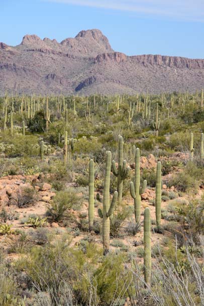
A view in Saguaro National Park (western district in the Tucson Mountains)

Saguaro National Park is split into two sections, the Western section (the Tucson Mountains) and the Eastern section (the Rincon Mountains). Amazingly, these two vast national park systems hug the east and west flanks of the bustling city of Tucson, which is home to about a million people.

Field of cactus Saguaro National Park Tucson AZ

.

The first thing we noticed as we drove through the park is that because the land is under strict preservation management by the National Park Service (as opposed to the looser standards that exist in the National Forests like Tonto National Forest up by Phoenix), is that there are lots of old saguaro cactus skeletons standing and lying around.

Saguaro skeleton Saguaro National Park Tucson Arizona

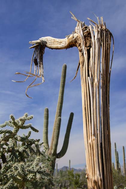
We were surprised to see cactus skeletons all over the place.

These unique relics are prized as garden and household decorations, and in the open Sonoran Desert that lies all around central and southern Arizona, they get hauled away by energetic folks to be re-purposed for interior decorating and outdoor garden ornamentation.

It was neat to see so many cactus skeletons in their natural desert home.

Cactus skeleton Saguaro National Park Tucson Mountains Arizona

The skeletal trunk of a saguaro cactus

Saguaros like to be warm, and they often get bent out of shape when there is a heavy frost. They drop their arms and never put them back up again!

swoopy cactus

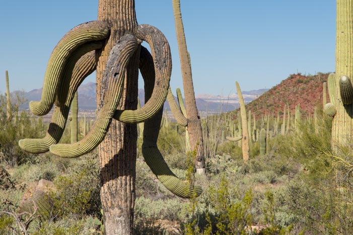
After a heavy frost or snow, the saguaros surrender with their arms down.

Saguaro National Park was first established in 1933. as a National Monument, and President Roosevelt’s CCC built some wonderful stone picnic ramadas that still stand today. The undersides of the roofs are lined with saguaro cactus ribs.

Picnic ramada built by CCC Saguaro National Park Tucson AZ

The CCC created wonderful stone picnic shelters lined with saguaro cactus ribs

Reading about the early history of this National Park, it was interesting again to see the differences between the National Park Service, which is a bureau of the Department of the Interior charged with preserving America’s natural treasures, and the US Forest Service, which is an agency of the Department of Agriculture charged with sustaining the health and productivity of the nation’s forests.

CCC picnic shelter Saguaro National Park Tucson Arizona

Cool view from the picnic ramada

Back in the 1930’s, the US Forest Service had been managing the land where the proposed Saguaro National Monument was going to be, and they didn’t want to give up cattle grazing on it, something the National Park Service would require. Fortunately, they eventually agreed to the concept of a National Monument in this forest of bizarre human-like trees. In 1994 it became a National Park.

The main loop drive through the cactus forest is a graded dirt road called the Bajada Scenic Drive, and there are several short hiking trails that go from there.

The Signal Hill hike follows a short path up to a pile of big boulders. Eons ago, the ancient Hohokam people pecked out a bunch of symbols and artwork on these boulders.

Petroglyphs at Signal Hill Saguaro National Park Tucson Mountains Arizona

At Signal Hill there are lots of intriguing petroglyphs

Some of the petroglyphs are like wheels with spokes while another popular image is an animal with long swept back horns.

The horned animal is a common motif seen in rock art all over southern Utah and Arizona, and usually it is referred to as a big horn sheep. But if you look at the horns on a big horn sheep, they are tightly wound and are nothing like the gently curved horns of these rock images.

big horn sheep petroglyph Saguaro National Park Signal Hill AZ

A “big horn sheep” petroglyph

I found an interesting photo-essay by a fellow who thinks these are not big horn sheep at all but are actually an extinct animal that roamed before the last ice age, an idea that would date the rock art to a far earlier period than is currently thought.

Talk about rocking the boat of the academics!!

Big Horn Sheep

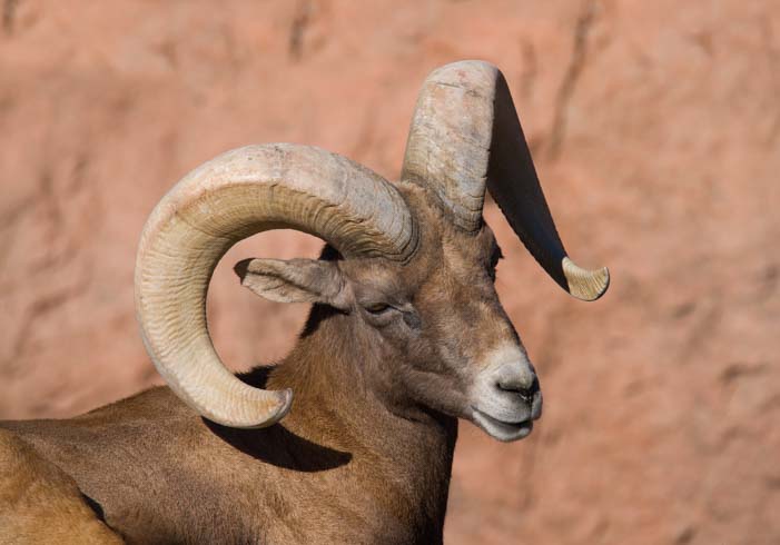
The horns on a big horn sheep are a lot more curved than ancient rock art images typically depict…

I don’t know if his theory holds water or not, but I love it when new ideas make us look at history and pre-history with fresh eyes.

A very large and tightly wound spiral image dominates the rock art on these boulders.

Signal Hill Spiral petroglyph Saguaro National Park Tucson Arizona

A large spiral image is the biggest petroglyph by far

Looking at this carefully pecked imagery, it is interesting to ponder what motivated those early people to make their art, and why they did it on these particular rocks, and whether it was just graffiti, or a warning, or a bit of news for the next folks coming down the path. Or perhaps it had some deeper spiritual meaning.

Spiral Petroglyph Signal Hill Saguaro National Park Arizona 2

.

Petroglyphs Saguaro National Park Tucson AZ

.

wheel sun sheep petroglyphs Signal Hill Saguaro National Park Arizona

.

Back on the path that leads from the parking lot to the mound of boulders, there is a bunch more rock art that is easy to miss on the way up. Just turn around as you begin to descend and keep an eye on the rocks. There is quite a bit there, fairly high up.

Signal Hill petroglyphs Saguaro National Park Arizona

If you don’t catch them on the hike up the hill, turn around on the way down and look up.

If you are really into rock art, taking along a pair of binoculars or a long camera lens is a great idea! I was glad to have my 28-300 zoom..

Spiral and people petroglyphs Saguaro National Park Signal Hill Arizona

Cryptic message, or spiritual symbols, or plain old graffiti?

Saguaro National Park is very large, and there are other hiking trails that can really get you out into the cactus forest. For this trip, we were just doing an overview and getting a feeling for what is there. We’ll dive in more deeply next time.

Hikers at Saguaro National Pak Tucson Arizona

We enjoyed this little foray into Saguaro National Park

Saguaro National Park is a really beautiful place to see Arizona’s Sonoran Desert scenery, whether you are an Arizona resident or are in the Tucson area as a snowbird RV visitor in the winter months. There are oodles of hikes and lots of ranger led events too, and there are links for more info below.

________________

Sometimes on this blog I put up a post with some beautiful photos only to discover later than I missed a few special ones that I’d really like to share. That happened with our earlier stay during the rains at Roosevelt Lake. The other day Mark and I were reminiscing about the bitterly cold week of rain and snow we experienced out there last month, and we came across these stunning photos of his. So here they are. Better late than never!!

Desert rain Roosevelt Lake Arizona

After the rain at Roosevelt Lake

While were camped at Roosevelt Lake, Mark snuck out of bed in the wee hours of the night and got this jaw dropping image of the stars:

Roosevelt Lake starry sky at night Arizona

Starry, starry night…

What a fabulous image!!

Subscribe
Never miss a post — it’s free!

Our most recent posts:

More of our Latest Posts are in the top MENU above.

More info about Saguaro National Park:

Related posts about Petroglyphs and the Sonoran Desert:

<-Previous || Next->

Tonto National Monument AZ – Workamping with the Ancients!

December 2015 – During our RV travels in central Arizona we took an outstanding volunteer-led tour of the ancient Indian “Upper Cliff Dwellings” at Tonto National Monument. We had already visited the “Lower Cliff Dwellings” on our own, as those are open to the public for exploration without a guide. But a visit to the Upper Cliff Dwellings can only be made if you take a guided tour.

Saguaro cactus with sunshine starburst

The hike up to Tonto National Monument’s Upper Cliff Dwellings goes through some beautiful scenery.

The cost was just the price of admission to the National Monument ($5 per person or free with a Federal Interagency Pass or Senior Access Pass). But that low cost was deceiving — this was no ordinary tour!

The depth of knowledge and enthusiasm of our guide, Susan Treneer, as she taught us about these ancient Indian ruins was unbelievable, and our whole group was fascinated as we listened to her explain the theories behind the history of this special place.

Upper Cliff Dwelling Tour hike Tonto National Monument Arizona

The hike was uphill but not too strenuous.

A group of about eight of us gathered at the Visitors Center and then hiked the 3 mile round trip up the steep hillside to the ruins and back. We began by going through some lovely riparian habitat (wetlands) where sycamores and other hardwoods were still showing off their autumn color.

Sycamore tree fall colors Arizona

A sycamore tree just off the trail in a riparian area.

Periodically, Susan stopped us as we hiked to explain the different vegetation we were seeing and to talk about the people who lived in the Tonto Basin 700 years ago.

Hike to Upper Cliff Dwellings Salado People Tonto National Monument Arizona

Susan pauses to tell us about the Salt River and the people who lived here centuries ago.

We climbed higher and higher on the hillside as we approached the cliff dwellings at the top, and the view of Roosevelt Lake grew more and more expansive below us.

Roosevelt Lake Arizona from Tonto National Monument

The views of Roosevelt Lake were outstanding.

Right before we entered the Upper Cliff Dwelling ruins, Susan brought out photos of some of the astonishingly beautiful and intricate pottery that the people of this place had made all those centuries ago. They are called the Salado People by archaeologists today, named for the Rio Salado (Salt River) that they lived near and which was dammed up in 1911 to create Roosevelt Lake.

Guided tour Upper Cliff Dwellings Tonto National Monument Arizona

Susan showed us photos of beautiful Tonto Basin pottery made right here centuries ago.

The Salado people were extraordinary potters, and their pottery has been found as far away as the Paquimé ruins in northern Mexico, some 350 miles or so southeast of Tonto National Monument.

Upper Cliff Dwellings Tonto National Monument Arizona

The people who built these ruins came down from Mesa Verde in southwestern Colorado and from other Colorado Plateau cliff dwelling communities.

Our guide, Susan, excitedly explained that no one really knows why the Salado built their homes in these caves so high up on the mountainside. She explained that the valleys were already filled with people living an agrarian lifestyle. Those old-timers had been raising cotton, beans, squash and corn in the Tonto Basin for 1,000 years already.

Ancient Indian upper cliff dwellings Tonto National Monument Arizona

The adobe structures had roofs made of saguaro cactus ribs and juniper. These are original!

The cliff dwellers were the newcomers to the area. They may have been artisans who wanted to make a life selling their unique tricolor pottery. Or they may have been workers for the wealthier farmers who lived below them. No one is 100% sure!

Ancient cliff dwellilngs Tonto National Monument Arizona

The adobe homes, storage rooms and workshops were built right into the caves.

All that is known is that they came down from the Colorado Plateau, and traveled through the Kayenta, Arizona, area, and ultimately set up housekeeping in the Tonto Basin and stayed for about 100 years.

Volunteer National Park Service Guide leads tour Tonto National Monument

Susan was extraordinarily knowledgeable about the ancient southwest cultures.

Susan’s enthusiasm for the subject was infectious, and it struck me that she was absolutely loving her wintertime volunteer job with the National Park Service at this special spot.

Salado cliff dwelling roof construction Tonto Basin Arizona

For archaeology buffs, working at a site that is being actively studied by scientists must be a thrill.

In between describing the tools and other relics that have been found at Tonto National Monument, she also told us that archaeology has been her lifelong interest. She hadn’t studied it formally or been a professional in the field during her career, but now, as a retiree, she was able to work alongside scientists and archaeologists studying this site and stay on top of the most recent findings and theories while “on the job” with the National Park Service. How cool is that?!

Tour group upper cliff dwellings Tonto National Monument Arizona

Most members of our group had traipsed through ancient ruins in Mexico and Central America
as well as all over the southwest.

Susan’s volunteer job requires 32 hours a week of work, and she has taken the position for a few months. In exchange, she receives an RV campsite with full hookups overlooking Roosevelt Lake. This may not sound like a very fair exchange if you multiply out the hours worked and the value of the campsite. Even if it were a resort campsite, like nearby Monte Vista RV Resort with its swimming pools, hot tubs, sports courts and art studios, the pay would equate to just $8.20/hour. However, there is a deeper meaning to doing this kind of work, and she was obviously thrilled to have the opportunity to learn about the ancient southwestern cultures in a professional setting and to share her passion with others.

Salado upper cliff dwellings Tonto National Monument Arizona

The public can only see the Upper Cliff dwellings on guided tours given on weekends.

Susan told me she has volunteered for the National Park Service for several years and has held similar positions at a few of the most significant ancient cliff dwelling ruins sites across the southwest, including Mesa Verde, Chaco Canyon and the Gila Cliff Dwellings.

In one job, she didn’t work with the public but spent her days cataloging and storing ancient pottery. She said that having the opportunity to hold, examine and study 700 and 800 year old pots — some of them perfectly intact — was just thrilling.

National Park Service volunteer leads tour of Tonto National Monument Cliff Dwellings Arizona

These ruins were overflowing with artifacts and debris when they were first studied 100 years ago. In those days tourists were free to take home whatever artifacts they found lying around!

I asked Susan how she got started with the National Park Service, and she explained that when she started as a volunteer, she had to undergo an intensive 40 hour training class and also do a beginner’s stint as a campground host at Big Bend National Park (not her favorite line of work). But it was clear that the personal rewards she has found since starting work at the various cliff dwelling sites have been enormous.

Short doorway Salado cliff dwelling Tonto Basin Arizona

The Salado people weren’t all that short — 5’6″ was average for men, the same as their counterparts in Europe – but the floor of the caves has built up over time.

Her enthusiasm for all things ancient and puebloan — like the small “T” shaped window that looked out from the window onto modern day Roosevelt Lake where the free spirited Salt River once irrigated the farmlands — was truly infectious.

Upper Cliff Dwellings Salado People Tonto National Monument T-Window

The “T” window shape was used by the ancients in many places. We remember seeing this shape at the Mayan ruins in Palenque in southern Mexico.

Lots of folks think “work camping” is simply working as a campground host checking people in and out of a campground or cleaning the bathrooms. But as I learned from Susan, if you have a passion for a particular field of study that is a focus of a particular National Park, like the puebloan culture and associated archaeological ruins, volunteering is a fabulous way to apprentice yourself to get hands on experience and learn everything you can.

Salado Matate Tonto National Monument Arizona

Susan pointed out a “matate” grinding stone that remains on site.

When Susan started, she was given a two page reading list of books to study. She was thrilled. “I like the intellectual stimulation,” she said. She wanted to spend her retirement not just traveling but learning new things and expanding her horizons in every way.

700 year old corn cob

Corn was similar but a bit smaller back then. This corn cob is 700 years old!

More than once she mentioned the names of the archaeologists who are her favorite mentors. They are pioneering new work on the origins, migrations and lives of the ancient people of the southwest, and some of their theories challenge those of the researchers of prior decades. So, their work is new, their ideas are fresh, and they are breaking new ground in understanding what the earlier people of the southwest were really all about.

Corn cob in adobe wall cliff dwellings Arizona

A corn cob got mixed into the adobe mud during construction and ended up in a wall!

We were totally impressed by the high quality of this tour. It felt like we were on a guided field trip with a true scholar. Susan had brought materials with her to show and instruct us, and she pointed out relics that were found at the Upper Cliff Dwellings and remain onsite and that the public can’t see without a guide. Best of all, she gave us insights into the lives of the people of an earlier time.

Charlie Steen shovel from 1930's excavation Tonto National Monument Arizona

The remains of a shovel used by archaeologist Charlie Steen during the 1930’s excavation of these ancient ruins.

Perhaps even more important, she opened our eyes to the kinds of volunteer work that are possible within the National Park Service and on public lands in general. It isn’t always just cleaning up after tourists!

Susan did say, however, that there is a lot of competition for the premium volunteer positions, and that you have to build your credentials and your resume, just as you would with a paying job. After all, they aren’t going to trust just anyone off the street with handling and cataloging priceless pottery that is centuries old! But once you get yourself established in the system, there are intriguing opportunities to learn and to share — and to get an RV campsite with a view too boot!

View from Upper Cliff Dwellings Tonto National Monument Arizona

Looking out over Tonto Basin from the back of the cave

If you have a chance to travel to central Arizona with your RV, take a trip to Tonto National Monument in the Tonto National Forest and see these wonderful ruins.

If you are lucky enough to be able to RV seasonally or full-time as a retiree, perhaps you too will pursue a lifelong interest by taking a short term volunteer position on America’s public lands!

There’s more info and links below.

Subscribe
Never miss a post — it’s free!

More info about Tonto National Monument and Workcamping:

Other posts from our RV and sailing travels to ancient Southwestern and Mesoamerican ruins:

Our most recent posts:

More of our Latest Posts are in the top MENU above.

<-Previous || Next->

Tonto National Monument AZ – Lower Cliff Dwellings

December 2015 – One of the treasures in the Sonoran Desert in Arizona is the exquisite sunrises and sunsets that light up the sky in vivid shades of pink and orange.

Arizona sunset fifth wheel trailer RV

Sunset over our fifth wheel

Another treasure that lies inside the Tonto National Forest near Roosevelt Lake high up on the mountain sides is the Tonto National Monument ancient Indian cliff dwelling ruins.

Lower Cliff Dwellings Tonto National Monument Arizona

Tonto National Monument Lower Cliff Dwellings

These ruins, built by the Salado people around 1300 A.D., are surrounded by saguaro cactus that stand so thickly on the hillside that, from a distance, they seem to transform the landscape into a pincushion! Up close, however, they are very tall.

Saguaro cactus Arizona Sonoran Desert

Saguaro cactus are very tall plants!

One of the best things about visiting the Tonto National Monument cliff dwellings is the half mile uphill hike to get to them. A narrow paved path takes numerous switchbacks up the hill, passing by dozens of beautiful saguaro cactus on the way to the ruins.

Tonto National Monument trail to Lower Cliff Dwellings

It is a half mile hike on a paved path through lush Sonoran desert to get to the ruins.

Saguaro at Tonto National Monument Lower Cliff Dwellings Arizona

.

As the path climbs ever higher, the view of Roosevelt Lake down in the valley grows ever wider.

Tonto National Monument view of Roosevelt Lake Arizona

The hike to the lower cliff dwellings is short and steep but has some incredible views of Roosevelt Lake

Then the ancient ruins appear, built into a huge cave in a sheer rock wall cliff face.

Cliff Dwellings Ancient Indian Ruins Tonto National Monument Arizona

High rise apartments!

It is startling, after climbing up through all the natural vegetation of the Sonoran Desert, to come face to face with the remnants of a distant culture’s masonry creations. The current theory is that the 20,000 or so Anasazi people who had built and lived in the immense Mesa Verde cliff dwellings in Colorado had left there for some reason and moved south, a few of them making their way through northeastern Arizona to the Tonto Basin to live here.

Tonto National Monument Lower Cliff Dwellings Arizona

You can wander freely in and around the Lower Cliff Dwellings

As a point of reference, in this same time period over in Europe, Florence had become the heart of commercial and cultural activity, and the Renaissance (the rebirth of interest in classical literature, art and music) was in its earliest stages.

At Tonto National Monument, the 700 year old walls are still standing, although they have broken down over time. With a little imagination, we could visualize the structure as it once stood as we moved from room to room.

Anclient Cliff Dwellings Tonto National Monument Arizona

Crumbling walls that must have many a story to tell…

There were quite a few rooms, most of them quite small, just 8′ square or so. The rooms near the front of the cave have a view across the valley to the lake.

Tonto National Monument Arizona Lower Cliff Dwellings

The ruins are built into a huge cave. The outer rooms have an incredible view!

Little openings led from one room to another, and the rooms stretched to the back of the cave.

Tonto National Monument Lower Cliff Dwellings Arizona

The cave faces east, so after about noon, it is shaded and cool, even in the blistering heat of mid-summer.

Tonto National Monument has two sets of cliff dwellings that are open to the public, the Lower Cliff Dwellings and the Upper Cliff Dwellings.

Lower Cliff Dwellings Tonto National Monument Arizona

.

Even though the Lower Cliff Dwellings are slightly smaller, the fun thing about them is that you are free to explore them at your own pace and they lie just 1/2 mile from the visitors center.

Tonto National Monument Salado Cliff Dwelling Ceiling

A few roofs made of juniper logs and saguaro ribs are still intact.

It’s a fairly steep hike to reach these ruins, but it is short, and the views along the entire trail are just wonderful.

Roosevelt Lake view Tonto National Monument Cliff Dwellings Arizona

Even if you’re not into ancient Indian stuff, the views are well worth the hike.

The hike to the Upper Cliff Dwellings is about 3 miles long, and those ruins are open to the public only on guided tours on the weekends. We took that hike too and will share photos in an upcoming post.

Saguaro cactus Tonto National Monument view of Roosevelt Lake Arizona

.

Tonto National Monument makes a terrific daytrip from the Mesa and eastern Phoenix area, and it is an absolute “must see” if you are camping at one of the campgrounds at Roosevelt Lake.

Sunset on Four Peaks at Roosevelt Lake Arizona

Sunset over Roosevelt Lake

A word of caution to travelers taking a big RV to this area: The once stunningly scenic drive along US-60 from Superior to Globe is now a chaotic nightmare of construction (probably in preparation for the world’s largest copper mine that will be built between the two towns). Even though the distance is 10 miles longer, it is a much less stressful (and also very scenic) rout to take SR-87 (the “Beeline Highway”) from Fountain Hills north to Punkin Center and then go south on SR-88 to Tonto National Monument.

Subscribe
Never miss a post — it’s free!

Our most recent posts:

More of our Latest Posts are in the top MENU above.

A little more about Tonto National Monument

Other fun excursions for RV travelers headed to Central Arizona plus some Indian Mystery:

<-Previous || Next->

Acadia National Park’s Carriage Roads in Maine – Thanks, Rockefeller!

June 2015 – One of the great treasures of Acadia National Park is the Carriage Road system. These roads, which are open only to non-motorized traffic, run all through the interior of the park for a total of nearly 50 miles, traveling through the woods, passing by lakes and ponds, and skipping over streams on beautiful old stone bridges.

We loved taking our bikes out on these roads during our RV travels to Maine.

Bicycling the Carriage Roads in Acadia National Park Maine

Heading onto the Carriage Roads in Acadia National Park

While we were there, we discovered that, like many of America’s national parks, we have the Rockefeller family to thank for this unusual road system. It turns out that the history behind the Carriage Roads is quite a tale.

Back at the turn of the 20th century when cars were first coming into use, the folks that lived on Maine’s Mt. Desert Island had a bit of a class war over whether or not automobiles would be allowed on the island’s roads.

The wealthy people who owned the summer estates (Pulitzers, Vanderbilts and others of their ilk) wanted Mt. Desert Island to be a rural getaway where they could travel about by horse and carriage and leave the hustle and bustle of the city and its newfangled automobiles behind.

The locals who called the island home all year long wanted the ability to get from town to town easily, and these newfangled automobiles were just the ticket.

Riding the Acadia National Park carriage roads in Maine

These wonderful roads pass several ponds and lakes.

The state of Maine left it up to the local communities to decide for themselves whether or not automobiles would be legal on each town’s roads. The upscale towns of Bar Harbor and Northeast Harbor, where the summer residents socialized and moored their yachts, voted to outlaw automobiles on their roads. The more working class towns, like fishing village Southwest Harbor, voted to allow automobiles on their roads.

In the end, after some human road blocks and a few arrests of automobile drivers caught flamboyantly breaking the law and driving on the wrong roads, by 1913 all the towns had agreed that cars were okay.

Biking under a stone bridge Carriage Road Acadia National Park Maine

Rockefeller hired masons to construct beautiful stone bridges.

I’m not sure where the Rockefellers stood on this issue — they lived in Seal Harbor at the south end — but John D. Rockefeller, Jr., decided to build a Carriage Road system just for horses and buggies. These roads went around the interior of the island and were available for everyone to use. This gave all visitors and residents of Mt. Desert a way to enjoy the peaceful inland forests up close, without a car.

John D., Jr., was an expert horseman and an experienced road builder, and he built lots of lovely roads and beautiful stone bridges. He kept buying up parcels of land and extending his road system until he had almost 50 miles of roads throughout the island.

Carriage Road signs Acadia National Park Maine

The trails are extremely well marked,
but carrying a map is a good idea!

In the 1930’s, the National Park Service began putting together the foundations of what would become Acadia National Park, and Rockefeller ultimately donated all of these land holdings — with their new road system — to the National Park Service to become part of the new park.

Riding bikes on Acadia National Park carriage roads in maine

What a wonderful way to experience the Maine woods.

I never knew much about the Rockefellers, but they are an incredible family. John D. Rockefeller, Sr., founded Standard Oil in 1870. By the end of his life in 1937 he had created a staggering personal net worth of $339 billion (in 2007 dollars).

It is impossible to compare wealth across the centuries accurately, but to try to put his riches in perspective, he was worth a whole lot more than the top 3 of the world’s wealthiest people today combined.

Bill Gates ($79 billion), Carlos Slim ($73 billion and Warren Buffet ($72 billion) are worth $224 billion all together. That’s $115 billion short of Mr. John D! Even adding in Mark Zuckerberg ($35 billion) leaves a gap of $56 billion.

To think of it another way, Rockefeller was worth 4.3 times what Bill Gates is worth. Imagine someone with assets and/or income 4.3 times more than yours. Or imagine someone with assets and/or income that is one quarter of yours. That’s the difference between John D. Rockefeller, Sr., and Bill Gates. Nevermind the difference between Rockefeller and the rest of us!

Horse drawn wagon on the Carriage Roads at Acadia National Park Maine

If you’re not into biking, there are other ways to experience the Carriage Roads!

What is more, somehow John D. Rockefeller managed to pass on an incredible sense of personal motivation and high standards to his children. And they somehow passed that on to their children too.

How common it is for the people who make the deepest impact on the world to have kids who flake out. Nevermind the flakey kids — who ever hears from the grandkids? In so many cases, the kids, grandkids and great-grandkids of the biggest movers and shakers of this world all float on their predecessor’s money with little motivation or interest in doing something remarkable.

Large turtle by the bike path

There’s lots of wildlife out here — this female turtle was busy laying eggs.

However, while John D. Rockefeller, Sr., was a ruthless, cut-throat, and not necessarily fair playing owner of a total monopoly in the skyrocketing oil industry, at the end of his life he turned his efforts towards philanthropy, and that is where his kids picked up the ball and where his grandkids carried it forward.

A snake next to a shoe

Just after seeing the turtle, we rode past a small snake.

John D. Rockefeller had seven grandkids, five boys and two girls. One of these grandchildren, David, is still alive. Reading a little bit about David Rockefeller, I learned he was a highly accomplished man who stepped out of the shadow of his dad and granddad and made his own indelible mark on the world.

He celebrated his 100th birthday a week before our visit to Acadia National Park, and the Park Service rangers were all abuzz with excitement because he had just donated a huge parcel of land adjacent to the park for public use in perpetuity.

Apparently David Rockefeller is quite a spry 100-year-old. A ranger told me she’d seen him cruising around on these Carriage Roads his father built in a horse drawn carriage!

Acadia National Park bridge on a carriage road

This bridge was a fun spot to take a short break.

The Rockefellers acquired and gave away massive tracts of land all over the place to preserve the most beautiful landscapes and make them available for everyone to enjoy.

When we were in Great Smoky Mountains National Park, we learned that half of the land that was donated and half of the money that was raised to create that park had come from the Rockefellers. The other half was provided by local landowners, residents and the National Park Service.

Half! That’s incredible!

The Rockefellers had a major role in the creation or growth of many other national parks too, including Shenandoah, Yosemite, Yellowstone, Grand Teton, Mesa Verde, Redwoods and the Virgin Islands.

Bike riding over a carriage road bridge in Acadia National Park Maine

We just loved these old stone bridges.

It is really easy to bash the ultra rich, or be envious, or question how they got their money, and on and on. But if it weren’t for the Rockefeller family using their staggering wealth to preserve these unique tracts of land, they would have fallen prey to development.

And the amazing thing is that the Rockefellers didn’t have to do any of it.

In the case of the Tetons, John D. Sr., had to put up quite a fight to get the National Park Service to take his land. The process was a bit of a nightmare, and he could have thrown up his hands and quit. But he didn’t.

So, we have the Rockefellers to thank for choosing (and sometimes fighting) to spend their money on us and on future generations of humanity.

Kayak on Jordan Pond Acadia National Park Maine

A kayaker at Jordan Pond.

David Rockefeller, who just gave away all that land on Mt. Desert Island a few weeks ago, is worth only $3 billion now, a mere fraction of what Bill Gates, Carlos Slim and Warren Buffet are worth. Obviously, he could be worth a lot more if the family had kept their money to themselves.

Perhaps with a nod to the example set by the Rockefellers, Bill Gates is busy giving away his fortune to fight disease and poverty in third world countries,. Three years ago, Warren Buffet gave each of his kids $1 billion with the requirement that they, in turn, give it away.

Lunch at Jordan House Acadia National Park Maine

The Jordan House is a great place to stop for lunch.

This is all very heady stuff, but the Rockefellers have been on my mind a lot since we started traveling, because their name keeps coming up at so many of the national parks we visit. The depth of caring in that family for the beautiful places in America seems to have extended through the generations.

Bicycling in Acadia National Park Maine

A wonderful spot for a bike ride!

We recently watched a thought provoking movie called America: Imagine The World Without Her. It’s a documentary made by a man who was born and raised in India, and it is fascinating to see this country through the eyes of someone who is not a product of it.

It’s a highly political film. However, it is well worth watching, because it makes you think about the origins and spirit of this country.

One of the most interesting points it makes is that after the American Revolution ended, and after General George Washington managed to wrest control of the locals away from the Brits, he broke with historical tradition.

Unlike all the leaders in human history up until that very moment, he did not proclaim himself King of this new country and give himself and his heirs absolute power and authority over the populace until the next overthrow.

He could have.

Jordan Pond Acadia National Park Maine

Jordan Pond is such a nice surprise in the middle of all these woods.

Since then, America has been a place of many kinds of firsts. Setting aside public land in the form of national parks was one, and the very first national park in the world was Yellowstone, created in 1872. Countries around the world have followed suit and preserved their natural treasures with gorgeous national parks that are open to the public. What a blessing for everyone alive today and for all that follow in the future, worldwide.

Bicycle at Bubble Pond Acadia National Park Maine

The Carriage Road at Bubble Pond.

It is highly ironic that the polluting combustion engine, fueled by oil drilled from nasty, dirty wells, created the fabulous wealth of the Rockefellers who then turned around a generation and more later and poured their profits into the national parks.

It’s ironic, too, that the family that benefited the most by the invention of cars and the related explosion in demand for oil was behind the creation of the unique Carriage Road system at Acadia National Park where the only legal traffic is human or horse powered.

Bicycling carriage roads under a stone bridge at Acadia National Park Maine

The Carriage Roads are very special!

I guess a leisurely ride or stroll on this special road system through the woods inspires a bit of reflection. It did for me.

If you do some RV travel in Maine, or if you visit Acadia National Park by some other means, make sure you spend a little time out on the Carriage Roads in Mt Desert Island’s forests. You may find new thoughts, ideas and musings stirring within you.

Subscribe
Never miss a post — it’s free!

Our most recent posts:

More of our Latest Posts are in the top MENU above.

For more info on all this, check out these links:

Related posts on similar themes:

More from our visit to Mt. Desert Island in Maine:

<-Previous || Next->

Acadia National Park – Alluring Beauty on the Maine Coast

June 2015 – Maine’s Mt. Desert Island (pronounced “dessert” despite the spelling!) is home to several small harbor-front towns as well as lovely Acadia National Park. We made a beeline for the trendy and chic seaside town of Bar Harbor as soon as we got there.

Two old cannons face the water in the middle of town, aimed almost directly at a pretty schooner in the harbor. Mark decided to have a look down the barrel of one!

Cannons and schooner Bar Harbor Maine

Boom!

It was early in the morning, well before the crowds of tourists began to fill the streets, and we enjoyed the quiet and peaceful feeling of the place. This is an upscale town loaded with high end galleries and boutique shops, and it was nice to walk the main street and window shop completely by ourselves for a while.

Boutique shops Bar Harbor Maine

Shops on the main drag in Bar Harbor

Another wonderful small waterfront town is Northeast Harbor (whose sister town, Southwest Harbor, lies across the bay). All of these towns made for fun excursions during our stay, and we spent many a happy hour walking along the docks and watching the boats in the harbor.

Boats in Northeast Harbor Maine

Scenic Northeast Harbor

A lot of Maine harbors are geered primarily towards the lobster boat fleet, but Northeast Harbor is also home to many beautiful sailboats — and some unusual looking ones too!

Antique ketch Northeast Harbor Maine

Northeast Harbor has sleek fancy yachts and cute antiques too

Mt. Desert Island is shaped something like a lobster claw with a pair of wide pincers hanging down. Acadia National Park takes up most of the eastern lobe and much of the western lobe too. In the eastern portion — the main part of the park — there is a Loop Road that passes the major sights.

The eastern 2/3 of this road is one way, and in our excitement to see it all on our first day in Acadia, we blew right by the visitors center, missed some key signs and wound up at the far end of the loop road facing the wrong way, trying to figure out how to see the park. Oops!

Scenic drive Acadia National Park Maine

The drives around Mt. Desert Island are wonderful

We got ourselves sorted out the next day and, map in hand, drove the loop clockwise as you are supposed to! Stopping at some of the viewpoints, we were quickly swept up in the beauty of the craggy shorline.

Crashing surf Acadia National Park Maine

Crashing surf on Maine’s rugged coast.

There were wonderful, huge granite boulders, and some of them even held tidepools. I love these northeast tidepools. There are whole ecosystems of algae, seaweed, periwinkels and limpets living in them, and many are lined with an ultra soft and rich red velvet that is some kind of algae.

Tidepools in rocks Acadia National Park Maine

We found lots of pretty tidepools

Rocky coast Acadia National Park Maine

We LOVED the mix of pine trees and jagged granite boulders on the coast.

I wandered way off so I wouldn’t keep getting in Mark’s photos, and around the bend I saw a lobsterman busy hauling his traps. I took a bunch of photos of him and then noticed that he waved to me. I took my camera down from my face to wave back. When I raised it again, I saw through the telephoto lens that he hadn’t been waving — he’d been holding up a wriggling lobster for me!

Unfortunately, he dropped the lobster into his bucket before I realized what he was doing, and I missed the shot.

Darn! The one that got away…

The one that got away!

I didn’t realize he was showing off a lobster for me to photograph until too late!

One of the most popular attractions at Acadia National Park is Thunder Hole, an opening in the rocks where the waves crash in and out, sending up a huge spray of water. To see the biggest spray, you have to catch it as the tide is coming in. The tide was going out when we swung by, but it was still neat to hear the gurgles, gulps and belches booming between the rocks far below as the waves washed in and out.

Thunder Hole - cool sounds on an outgoing tide and huge splashes on an incoming tide

Thunder Hole – Booming sounds on an outgoing tide plus huge splashes on an incoming tide.

This shoreline is very alluring, and we had such fun scrambling over the rocks.

Rock crevice Acadia National Park Maine

I swear, these kinds of big boulders bring out the kid in me.

These are SO MUCH FUN to run around on!

What a coastline! If you don’t want to run and jump on the rocks, Thunder Hole has a solid railing…

Dramatic sky Acadia National Park Maine

A touch of drama in the sky.

Acadia National Park is a very popular place, and the park was very busy even though we had arrived ahead of the summer crowds (New England public schools were still in session because they’d had so many snow days during the endless winter blizzards). The roads are narrow and winding, and some crazy people like to bomb down them like they’re a racetrack.

One group of travelers, however, was enjoying every minute of slow driving on these roads — a Ford Model A club! They were so cute that none of the other drivers objected to their pace. Some 170+ Model A’s attended this rally, and everywhere we went we ran into little groups of them.

Seeing them out on the roads was lilke stepping back in time.

Antique Model A drives up Cadillac Mountain Acadia National Park Maine

A Ford Model A rally took us back in time.

This group was having a ball, and the weather was perfect for them, so they drove around with the tops down and their beautiful leather suitcases strapped on the back bumpers.

Happy driver of a Ford Model A

Those guys were having too much fun!

Enjoying a fabulous road trip!

Enjoying a fabulous road trip!

Ford Model A cars lined up

These guys were all over the park. What fun!

Another Acadia National Park favorite is to take a drive to the top of Cadillac Mountain, the highest point in the park. We zoomed up the mountain, watching the views grow ever larger around us. And who was waiting for us at the top? A bunch of those Model A’s!!

Ford Model A parked on Cadillac Mountain Maine

View from the Top

The views were truly beautiful — you can see the many islands of Frenchman Bay in the distance — but we got the biggest kick out of watching these cute Model A’s drive down these wonderful roads. They had come to Acadia National Park from all over the country, most making the trip on their own four wheels. One club member even hailed from Australia, although he’d left his Model A at home.

Ford Model A car drives down Cadillac Mountain Acadia National Park Maine

What a classic image descending Cadillac mountain!

Two Ford Model A cars descend Cadillac Mountain Acadia National Park Maine

.

If you take your RV to Mt. Desert Island, unless it is fairly short in length and short in stature, you’ll be happiest leaving it behind as you tour the park. The scenic viewpoint parking is not RV friendly and there are bridges on the Loop Road as low as 11′ 8″. We enjoyed a fabulous stay at Narrows Too RV Resort, about 7 miles north of the north entrance to the park.

Subscribe
Never miss a post — it’s free!

Our most recent posts:

More of our Latest Posts are in the top MENU above.

For More Info:

Other blog posts from our RV travels in Downeast Maine

Here are some of our blog posts with similar themes!

<-Previous || Next->

Shenandoah National Park, Virginia – Climbs & Falls!

June, 2015 – The Blue Ridge Parkway connects Great Smoky Mountains National Park in North Carolina with Shenandoah National Park in Virginia where the Parkway morphs into Skyline Drive. The difference between the Blue Ridge Parkway and Skyline Drive is very subtle, as both of these long drives is a winding, hilly road under a canopy of green trees.

RV driving Skyline Drive Shenandoah National Park Virginia

Skyline Drive in Shenandoah National Park

As we drove on Shenandoah’s Skyline Drive, we began seeing more rock faces on the sides of the road, and there were more open areas where the views opened up.

Unlike the Blue Ridge Parkway where many scenic overlooks actually have no view at all because overgrown trees stand in the way, Shenandoah National Park’s scenic viewpoints all feature a real view. We saw some lovely vistas of mountains fading off into the distance. This difference may be due, in part, to the fact that the Blue Ridge Parkway, which is managed by the National Park Service, is free for all travelers to use, whereas Shenandoah NP, which Skyline Drive traverses, charges the usual National Park fees.

Mountains in Shenandoah National Park Virginia

“Thousands of tired, nerve-shaken, over-civilized people are beginning to find that
going to the mountains is going home.” — John Muir, 1914

When all the great national parks in the western states were being built in the early 1900’s, there was a desire in the eastern states to create a similar park that set aside beautiful lands and made them available to people for recreation. The tricky part was that most land was already privately owned. Shenandoah was created in 1935 through government acquisition of private land by eminent domain. Before it was even officially open, the crowds arriving from Washington, DC, and other nearby cities to enjoy the great outdoors were staggering.

Traffic in Shenandoah National Park Virginia

A Shenandoah scenic overlook circa 1935

The crowds can be overwhelming today too, and at a few of the hiking trailheads we found it was nearly impossible to find a parking space. Just like the Blue Ridge Parkway, this is a road that is loved by motorcyclists as well as motorists, and we saw many groups of them out having a ball on these twisty mountain roads.

Motorcycles on Skyline Drive Shenandoah National Park Virginia

Skyline Drive is a favorite with motorcycles

There is still plenty of peace and quiet and wildlife in Shenandoah, however. We saw lots of deer, including one that sprinted across the road in front of us. Even more exciting, on one of our hikes Mark spotted a black bear just 100 feet from the trail. We both tried like crazy to get a good photo, but he kept his rump to us and a thousand skinny tree branches obscured our view of him. Oh well. It was still really cool to watch him going about his business in the woods.

Deer crossing Skyline Drive in Shenandoah National Park

We saw lots of wildlife in Shenandoah

We decided to do one waterfall hike in Shenandoah to wrap up our waterfall theme on this leg of our travels. We had just about had our fill of waterfalls — who would have thought that was possible back in the Smokies? — but we had room for one more.

Dark Hollow Falls is a beautiful waterfall that has an upper section and a lower section. We hiked down from the top (although lots of people came via a different, easier route), and the view looking up at the upper falls was wonderful.

Dark Hollow Falls Shenandoah National Park Virginia

The upper falls at Dark Hollow

We were there on a Sunday, and the crowds were thick. People waited and took turns getting photos of themselves standing on the rocks at the base of the waterfall, and the trails were loaded with people of all ages.

The hike down from there to the lower falls was easy and the lower falls were very pretty too.

Dark Hollow Falls Shenandoah National Park Virginia

Dark Hollow Falls lower waterfalls

Dark Hollow Falls Virginia Shenandoah National Park

The lower falls at Dark Hollow

Dark Hollow Falls Virginia Blue Ridge Parkway

Lower waterfall at Dark Hollow Falls

We also hiked to Mary’s Rock. This time we went midweek, and we were the only ones on the trail. There was a lot of activity in the woods around us, however. Squirrels made noises in the underbrush and songbirds filled the air with beautiful warbling.

Hike to Mary's Rock Shenandoah National Park Virginia

The hike to Mary’s Rock goes through some wonderful woods

Ferns in Shenandoah National Park Virginia

A trio of ferns against a tree

Leaves

Beautiful leaf patterns

We came across a strange rock chimney standing in the middle of the woods. There was no plaque or marker on it. Just the chimney standing there. Adding another odd note to this weird orphaned chimney, we found a brand new Keene sandal sitting right in the middle of the trail. Hmmm… something old and something new!

Mary's Rock Summit Hike Chimney

We came across an unexpected chimney and a new lone Keene sandal

After taking a left turn near the end of the hike, the trail suddenly opened up, and we were staring at Mary’s Rock and the vast rolling green hills beyond and far below.

Mary's Rock Summit Shenandoah National Park Virginia

The summit of Mary’s Rock

There were lots of big boulders all around, and we had fun scrambling to different peaks and pinnacles.

Standing atop Mary's Rock Summit Shenandoah National Park VIrginia

There are great views from the tippy top!!

Mary’s Rock is at the north end of Shenandoah National Park, and this hike was our last foray into the ribbon of national park lands that stretches nearly 500 miles from Cherokee, North Carolina to Front Royal, Virginia.

Summit of Mary's Rock Hike Shenandoah National Park Virginia

Happy hikers

We had finished our nearly four week trek north along this unique strip of lush mountains, and as we put away our hiking shoes and camelbacks for the last time, we knew we’d barely scratched the surface of this rich area. We’ll be back for sure! But for now, it was time to switch mental gears to get ready for our upcoming summer RV adventures that awaited us far to the north.

Subscribe
Never miss a post — it’s free!

Our most recent posts:

More of our Latest Posts are in the top MENU above.

More info about these hikes:

Other blog posts from the the lush and beautiful Blue Ridge Range:

<-Previous || Next->

Blue Ridge Parkway (Virginia) – Waterfalls & Rhododendrons

May, 2015 – As we took our RV north through Virginia, hopping on and off the Blue Ridge Parkway, we followed the blooming of the rhododendrons as they blossomed first in the south and then in the north. In fact, we followed the rhododendron bloom all the way from the Smokies to northern Maine over the course of five weeks! We also decided to contine the travel theme we had begun in the southern part of the parkway in North Carolina: Waterfalls.

Rhododendron selife Crabtree Falls Blue Ridge Parkway Virginia

Lavender rhododendrons and stairs defined our Blue Ridge Parkway waterfall hikes in Virginia

Seeing waterfall pics is very inspiring, but actually getting to them on a hiking trail usually involves a lot of vertical hiking, either climbing up to the top of a waterfall or scrambling down to the bottom of one. We got some great stair-stepping workouts on our quest for beautiful waterfalls in the Virginia portion of the Blue Ridge Parkway!

APPLE ORCHARD FALLS

The first waterfall we went to was Apple Orchard Falls. This hiking trail crosses the Appalachian Trail, and we were astonished as we approached the intersection with the Appalachian Trail to meet a fellow who was spending his summer hiking from Georgia to Maine!

This hiker, Brian, was traveling light for a 4 month walk in the woods, but he said he was doing great. Unlike most of his fellow hikers, he hadn’t had to replace his hiking shoes yet, and he’d knocked out 770 miles of the trek with another 1,400 or so to go before he reached Mt. Katahdin in Maine.

Appalachian Trail Through Hiker Brian (Porkchop)

Brian is walking from Georgia to Maine this summer, and we met him 1/3 of the way into his trip.

We bounded down the trail to the bottom of Apple Orchard Falls after that encounter, so excited to have met an Appalachian Trail through-hiker in the middle of his journey. At the bottom we found a pretty waterfall cascading over the rocks.

Apple Orchard Falls Blue Ridge Parkway Virginia

Apple Orchard Falls

Better yet, there were rhododendrons blooming all around the lower part of the waterfall and even more along the stream that fell loosely over the rocks into the woods. We were in seventh heaven running around taking pics. In no time we were in our own worlds, totally separated. It was long after we were out of sight of each other that we realized we’d left our trusty two-way radios in the truck. I had no idea where Mark went, but I followed the rhododendrons!

Rhododendrons Apple Orchard Falls Blue Ridge Parkway Virginia

Rhododendrons were blooming all over the place

Rhododendrons are a magnificent flower, and I crouched and crawled and snuck under branches along the river banks to try to find places to get pics of them with flowing water. I couldn’t believe they grew wild in such abundance. Everywhere I looked, they were in all stages of bloom:

04 406 Rhododendron blooming 1

05 406 rhododendron blooming 2

Rhododendron blooming 5

.

Rhododendron blooming 6

.

When I’d had my fill of rhododendrons and waterfalls, I hiked back to where I’d last seen Mark at the bottom of the falls. I searched around there for a long time wondering where he’d disappeared to along the creek. I yelled his name, bunches of times, but there was no answer. Oh no!

The return hike to the truck was a one and a half miles or so straight uphill. This trail was STEEP, and I was torn. Should I stay at the bottom? Should I go back to the top?

I finally decided to take the chance that he had gone back to the top. It was late, after all, and if he couldn’t find me I figured he’d return to the truck up top. I hiked nervously straight uphill, sweat pouring down my back.

What if he wasn’t at the top? I wondered. Would it make sense to go back down to the bottom to look for him? And what if I couldn’t find him down at the bottom? Should I then hike back up again?

At exactly what point would I try to get help? And how many miles away would help be? And would those helpful people then hike to the bottom to look for him this late in the day or wait til tomorrow? What if he’d gotten injured and couldn’t move? My imagination ran wild.

Apple Orchard Falls Blue Ridge Parkway VIrginia

Apple Orchard Falls

I continued yelling for him periodically, morosely envisioning the headlines, “Dead hiker found at waterfall, two-way radios found in truck.” How foolish of us!

As I hiked the last 100 yards straight uphill I craned my neck looking for the truck. When I finally caught a glimpse of it just beyond the last tree, I saw the door was open and Mark’s smiling face poked out from behind it and we both ran and gave each other a huge hug. What a relief!

Fallingwater Cascade Blue Ridge Parkway Virginia

Fallingwater Cascades — with overhanging rhododendrons

FALLINGWATER CASCADES

The next hike proved much more straight forward. Fallingwater Cascades is just five miles away from Apple Orchard Falls, and is a much shorter and easier hike.

Fallingwater Falls rhododendrons Virginia

Fallingwater Cascades

The rhododendrons were blooming here too, but I stayed on the trail this time. The waterfalls were lovely.

Fallingwater Falls Virginia

Fallingwater Cascades

CRABTREE FALLS

Our final waterfall hike along the Blue Ridge Parkway in Virginia was Crabtree Falls. When we saw the name of this waterfall we did a doubletake because we had already hiked a Crabtree Falls in the North Carolina part of the Blue Ridge Parkway a week or so ago.

12 406 Fallingwater Waterfall Blue Ridge Parkway Virginia

So we were surprised when the gal at the visitors center who told us about Crabtree Falls in Virginia had never heard of the one in North Carolina. However, the Virginia falls is the tallest waterfall in the east, a claim to fame the North Carolina Crabtree Falls doesn’t have.

Crabtree Falls Blue Ridge Parkway Virginia lower waterfall

Crabtree Falls — Lower falls

We found out that when you hike the tallest waterfall in the east, you are in for a LOT of stair climbing. Crabtree Falls consists of three waterfalls sections that are each unique, and between each section there are staircases and some steep trails.

Crabtree Falls hiking trail Blue Ridge Parkway Virginia

Not only is this hike steep, but there are a ton of stairs!

Each staircase brought us to more waterfalls.

Lower Crabtree Falls Blue Ridge Parkway Virginia

Crabtree Falls

And then we climbed more stairs!! Some stairs were built into the trail. Others were just plain old staircases!

Hiking trail stairs Crabtree Falls Blue Ridge Parkway Virginia

In some places the stairs look natural, and in some places they are just staircases.

After the stairs we saw another bit of the waterfall. Different shape. Same falls!

Middle Crabtree Falls Blue Ridge Parkway Virginia

Crabtree Falls

As we climbed higher, we got more and more tired. And obviously the rangers did too, because up near the top they quit building stairs and just let the tree roots be the stair cases!

Root staircase Crabtree Falls Virginia

Nature’s Staircase!

At the very top of the waterfall, the stream flowed between the rhododendron bushes and then fell right out in front of them. Just beautiful. And this time, since we had started the hike at the bottom and had climbed to the top, we gleefully ended our hike by descending down the stairs instead of trudging up!!

Top Crabtree Falls Blue Ridge Parkway Virginia

Crabtree Falls

If you take your RV along the Blue Ridge Parkway, the parkway itself is fine for driving except for two low bridges at the far south end in North Carolina.

No matter where you drive in this area, be prepared for steep hills. We were very grateful driving in these hills to have recently outfitted our truck with a diesel engine tuner to improve its towing power and to have outfitted our trailer with electric over hydraulic disc brakes.

Subscribe
Never miss a post — it’s free!

Our most recent posts:

More of our Latest Posts and Quick Pics are in the top MENU above.

More info for these waterfall hikes:

Related posts from North Carolina and Virginia:

<-Previous || Next->

Blue Ridge Parkway Highlights (Virginia) – Mills, Music & Farms!

May, 2015 – As our RV travels along the Blue Ridge Parkway took us north from North Carolina over the border into Virginia, we stopped at the Mabry Mill. This beautiful old mill was built by one Edwin Mabry who used it to grind corn and saw lumber for his neighbors in the early 1900’s.

RV and Mabry Mill Blue Ridge Parkway Virginia

A motorhome passes the Mabry Mill in Virginia

We arrived in in the third week of May, just as the rhododendrons began blooming. There is something about an old wooden building like this with flowers and a paddle wheel outside that just begs to be photographed. Especially when water is splashing off the paddle wheel!

Mabry Mill Blue Ridge Parkway Virginia

The rhododendrons were just coming into bloom

We found out that this mill is one of the most photographed buildings on the whole Blue Ridge Parkway! So, we we had to add ours to the mix…

Mabry Mill selfie Blue Ridge Parkway Virginia

A serene setting…

Mabry Mill Virginia Blue Ridge Parkway

Inside the mill, an old fellow showed us how a very long lever arm is used to start and stop the flow of water over the paddle wheel. This effectively turns on and off the power that the wheel generates. It also explained why, when we were outside taking pics, the paddle wheel would periodically turn and dump some water and then stop spinning and sit still for a while. The guy inside was showing people how it turned on and off!

Inside Mabry Mill generating power

A long lever arm controls the water flow to the paddle wheel.

Edwin Mabry used the power from the mill to do all kinds of things that electricity would do today

Visiting places like this always makes me marvel at how easy so many things are today. What a huge effort it was to grow grains, harvest them, separate out the seeds to be ground, take a bag of them to your neighbor’s mill to get it ground, and then go home and bake some bread. I would cherish every slice of that loaf!

Mill saw inside Mabry Mill Virginia on the Blue Ridge Parkway

The old mill saw — powered by the paddle wheel!

As we drove on the Blue Ridge Parkway, we found that much like the Smoky Mountains a little further south, the views out across the mountains and valleys form layers that fade into the distance. “Smoky” and “Blue” are very apt names!

Blue Ridge Mountains on the Blue Ridge Parkway in Virginia

Blue RIdge Mountains

Just a bit south of the Mabry Mill on the Blue Ridge Parkway, we visited the Blue Ridge Music Center. This fantastic little museum is maintained by the National Park Service, and it explains the history of bluegrass and mountain music. We discovered that bluegrass is an amalgam of all the musical traditions from the people that were living in these mountains over a century ago.

I had never known this, but the banjo is an instrument that was brought over from Africa! The lyrics, patter and general style of bluegrass music can be traced to traditional Irish folk songs. And the purely vocal harmonizing has its roots in German liturgical music. All of these different kinds of musical traditions blended together here in the Appalachian mountains, and over a period of time, bluegrass music emerged.

Old photo of blacks playing banjo and guitar

The banjo came from Africa!

The best part of the Blue Ridge Music Center is that it’s not just a museum. It’s a place for enjoying music! Every afternoon from noon until 4 pm, musicians perform for free in the breezeway which is a big open room right next to the museum. It has a large barn door that can be left open to make the room airy and breezy or can be closed. It’s very informal. Folding chairs are set up in front of the performers, and people come and go, enjoying the music all afternoon.

Live bluegrass music at Blue Ridge Music Center_

Scott Freeman & Willard Gayheart perform bluegrass music for tourists courtesy of the National Park Service. Different musicians play for free for 4 hours every day!!

We saw Scott Freeman & Willard Gayheart while we were there, and we were floored by their wonderful playing. For those who want more music, the Blue Ridge Music Center hosts a complete outdoor summer concert series that takes place on a stage in front of a big lawn.

Just 40 miles away in the town of Floyd, we found that there is all kinds of blue grass and old time music going on for free, or close to free, in the Floyd Country Store (blog post here) — and what a great time we had there!

Republic of Floyd Virginia

Quietly defiant Floyd Virginia hosts free bluegrass concerts. They sometimes spill out onto Main Street, even though it’s a major state thoroughfare!

We traveled on the Blue Ridge Parkway itself a little, but we did most of our driving on the roads that criss-cross the parkway and run parallel to it. This is an extraordinarily hilly area, and we found ourselves constantly driving either up a steep grade or down one, which made us very happy we had done the disc brake conversion upgrade on our trailer a few months ago in Texas.

It seemed to be a daily occurrence that Mark suddenly blurted out, “I love these new brakes!”

As we approached Hillsville, Virginia, on Memorial Day Weekend, we found ourselves not only in the hills but caught up in some really crazy traffic as the whole town put an enormous yard sale as part of their Memorial Day Flee Market!

Traffic and hills in Hillsville Virginia

Crazy traffic and steep hills on Memorial Day in Hillsville Virginia

But as we ventured north, taking in some of the highlights of the Blue Ridge Parkway, whenever we got away from the cities and towns, the countryside became wonderfully rural, and we passed one beautiful farm after another.

Farm in southwestern Virginia near Blue Ridge Parkway

We saw lots of farms as we drove around.

Virginia farms

Picturesque farms in the countryside

We even passed an old RV parked next to some very tidy rows of vegetables.

RV on a farm in Virginia

A vintage RV with new crops coming up.

This is a pretty part of the country!

10 771 Farm in southern Virginia

Virginia farm near the Blue Ridge Parkway

More lovely Virginia farms…

16 701 Blue RIdge Parkway area farm in Virginia

If you take your RV to the Blue Ridge Parkway, you’ll find mills, music, farms and much much more!

Subscribe
Never miss a post — it’s free!

Our most recent posts:

More of our Latest Posts and Quick Pics are in the top MENU above.

More info from this part of the Blue Ridge Parkway:

Related posts:

<-Previous || Next->

Waterfalls of the Blue Ridge Parkway (North Carolina)

May, 2015 – The Blue Ridge Parkway is 469 miles long, and it creates a link between Great Smoky Mountains National Park down south in North Carolina with Shenandoah National Park up north in Virginia. It’s a very skinny road, and private land abuts it on both sides, so most of the attractions are just off of it to one side or the other.

There is so enormously much to see and do along this long stretch of road that we decided we’d shape our Blue Ridge Parkway adventures by having a theme: waterfalls.

We’d had a lot of fun exploring some of the waterfalls in Great Smoky Mountains National Park, so we started hunting for more waterfalls as we traveled northeast along the parkway. The first one we went to was Soco Falls. It’s fairly close to Cherokee, North Carolina, where we’d been staying for a while.

SOCO FALLS

Soco Falls Blue Ridge Parkway North Carolina

Soco Falls near the Blue Ridge Parkway in North Carolina

The hike down to Soco Falls is steep but quite short. There is a viewing platform partway down, but the real beauty of the falls lies well below that at the very bottom of the falls.

We had to scramble a little bit on the slick muddy trail to get down to the bottom. Luckily, there was a strong rope strung between some trees to give hikers a handhold in the steepest parts. Once we got down to the bottom, the view looking back up at the falls was spectacular.

Soco Falls Blue Ridge Parkway North Carolina

Soco Falls

Soco Falls Blue Ridge Parkway North Carolina

Hiking below the viewing platform takes you to the best views!

Soco Falls Blue Ridge Parkway North Carolina

Looking up at the falls from the bottom

A group of local kids was down at the bottom of the waterfall too, fishing. “Look, we’ve caught 8 fish!” one of them told Mark excitedly, holding up a small canvas bag in his grubby hand. Mark asked what they planned to do with them. “Eat them, of course!” the kid said, giving Mark a funny look.

The kid vanished lower down the falls, and then came back up again a little while later. “What are you doing?” he asked Mark as he stared at his camera and tripod. When Mark said he was taking pictures, the kid asked what for. “To look at, of course!” Mark said. This time he gave the kid a funny look!

Soco Falls Blue Ridge Parkway North Carolina

What a beautiful place…

Whether you come to these falls to fish or to take photos to look at later, they’re wonderful. The hike to the bottom is well worth the little bit of extra scrambling to get all the way down, even if it’s muddy.

DUGGERS CREEK FALLS

The next waterfalls we wanted to see were Linville Falls and Duggers Creek Falls which are both reached from the same trailhead parking area. At the Linville Falls Visitors Center, we saw a breathtaking photo of Duggers Creek Falls and decided to do that hike first.

The skies were getting dark, however, and we joked with the ranger that we really ought to buy two of the rain ponchos they had for sale, just in case. But we didn’t. In fact, Mark even left his rain jacket in the truck.

Linville Falls VIsitor Center Blue Ridge Parkway North Carolina

Mark feeds a raccoon on a painting at the Linville Falls Visitors Center.

The hike to Duggers Creek Falls isn’t very long, and we had just gotten to the bridge down near the waterfall when the skies opened up. We hid out under a rock outcropping for a little bit, but the rain went from simply pouring to coming down in torrents. In no time, we were drenched, especially Mark without his jacket. We decided to make a run for it back to the visitors center.

Linville Falls hike to Duggers Creek Falls

Duggers Creek Falls is beside that bridge

As soon as we walked in the door of the visitors center, Mark grabbed two rain ponchos off the shelf and slapped them down next to the cash register. Water was dripping from his soaking wet hair right down his nose as he handed the clerk his credit card. How funny!

Of course, after about half an hour or so the sun came out. So, down the trail we went once again. This time we were not only both wearing our rain jackets but we had our nifty new rain ponchos tucked into our packs too. Surely, that guaranteed the sun would stay out!

Duggers Creek Falls Blue Ridge Parkway North Carolina

A view of Duggers Creek Falls from the bridge

We took the shortcut hike from the far end of the parking lot this time, and when we got down to the bridge, the view of the waterfall was lovely. But the falls are set far back from the bridge, and they weren’t nearly as dramatic as the photos we’d seen.

Then we realized that the best spot to see these falls was from under the bridge! Mark waded out into the water with his tripod.

Duggers Creek Falls Linville Falls Blue Ridge Parkway North Carolina

The better view of the falls was from under the bridge — and out in the water!

He got some beautiful photos.

Duggers Creek Falls

Duggers Creek Falls

Suddenly, he jumped. “Ow!” He said. “I’m getting bitten!” He slapped something off his leg. It was a little lobster looking creature — a crayfish, or a crawdad thing with claws. It had crawled up his leg and nipped him! Yuck!! But the beautiful photos were worth it.

Duggers Creek Waterfall Blue Ridge Parkway North Carolina

Duggers Creek Falls

We were both playing with using long shutter speeds to make the water smooth, and soon we noticed that the foam and bubbles at the bottom of the waterfall were drifting downstream and making wonderful patterns on the surface of the water in our photos.

Waterfall foam streaks water at Duggers Falls

We got a kick out of playing with the foam patterns.

The foam streaked past us in all kinds of interesting lines and shapes. At one point it even flowed in a circle, and I just happened to catch that moment with my camera.

Duggers Creek Waterfall Swirling Water

I got a shot where the foam went in a circle. Cool!

We ended up enjoying Duggers Creek Falls so much — and for so long — that we never made it to Linville Falls. Oh well. Next time!

CRABTREE FALLS

The last waterfall we visited on the North Carolina end of the Blue Ridge Parkway was Crabtree Falls.

Crabtree Waterfall Blue Ridge Parkway North Carolina

Crabtree Falls – North Carolina

The hike down was pretty easy (although the return trip was a bit of a workout), and the waterfall was a fabulous and dramatically steep cascade over lots of big rocks.

Crabtree Falls Blue Ridge Parkway North Carolina

Crabtree Falls is a neat cascade that goes over lots of different rocks on its way down

A closeup of a tree in front of the falls made for a beautiful, mystical shot right out of a Tolkien fantasy.

Crabtree Falls Blue Ridge Parkway North Carolina

A world apart

While I had been busy getting my mystical closeup of the tree against the waterfall, I discovered that Mark had been busy taking photos of a cute blonde girl sitting on a rock with the waterfall as a backdrop. Hey! Granted, she’d asked him to take her pic, and sure, she was thrilled to get the photo for her facebook friends. But…

Soon she disappeared up the trail, and we posed ourselves on the same rock to get a nice selfie. How lucky we were to be enjoying another gorgeous waterfall!

Crabtree Falls Blue Ridge Parkway North Carolina

We were loving these waterfalls on the Blue Ridge Parkway!

There are dozens and dozens of waterfalls along the Blue Ridge Parkway, especially at the southern end. These three — Soco Falls, Duggers Creek Falls and Crabtree Falls — are all stunning waterfalls that are easy to reach.

If you take an RV roadtrip along the Blue Ridge Parkway — whether driving the RV directly on it or driving on the roads nearby — any one of these waterfalls makes for a really fun excursion.

Subscribe
Never miss a post — it’s free!

Our most recent posts:

More of our Latest Posts and Quick Pics are in the top MENU above.

Here’s a little more about each waterfall:

Other posts from this general area:

<-Previous || Next->

Smoky Mountain Adventures – Elk, Indians and Waterfalls

May, 2015 – The Smoky Mountains in North Carolina are filled with beautiful streams and rivers, and late one afternoon, we caught the Oconaluftee River glinting orange in the afternoon sun.

River at dusk Smoky Mountains North Carolina

Golden light on the river.

The rhododendrons had begun blooming, and their little purple faces peeked out from the edge of the glowing river water.

Rhododendrons and river reflections Smoky Mountains

Rhododendrons at dusk.

We didn’t have to stray far from the town of Cherokee to become swept up in the vivid green forests of the Smoky Mountains. The Oconaluftee River Trail goes for about 1.5 miles from the Cherokee Welcome Center in town out to the Great Smoky Mountains National Park Oconaluftee Visitors Center. When we tipped our heads back anywhere along this path we saw trees reaching right up to the sky.

Green treetops

The Smoky Mountains woods are very green!!

The Oconaluftee River Trail is ideal for walking, running or biking, and we took a run or rode our bikes on it most mornings during our stay. The ground is soft, and the path is wide, and no one is out there early in the morning.

Biking Oconaluftee River Trail Great Smoky Mountains National Park

The Oconaluftee River Trail is a lovely woodsy path for walking, jogging or biking.

There are signs on the trail that say elk are in the area, but who believes signs like that?

Elk in Great Smoky Mountains National Park North Carolina

Hey, it’s an elk!

Well, believe it! One morning Mark stopped dead in his tracks ahead of me when he saw a bull elk and his harem of females standing hoof deep in the river getting a morning drink. He could practically reach out and touch them!

Elk in Oconaluftee River Great Smoky Mountains National Park

A female elk walks downriver

Where was the camera? Neither one of us had taken a camera on our run. But when we went back on our bikes one morning a few days later, we saw the elk again, and this time I had my trusty pocket camera with me.

Elk and mountain bike on hiking trail

Another elk stands in the trees by the trail (left)

A female elk came right to the edge of the River Trail and hung out for a while, not seeming to be the least bit concerned about me as I laid my bike down and walked over towards her. She nibbled the greenery around her and kept a close eye on me, turning her head this way and that to get a better look.

Elk on Oconaluftee River hiking trail Smoky Mountains

This collared female elk keeps an eye on me.

The elk in the Smoky Mountains were reintroduced in 2001-02, and this one had a collar on her so the rangers could keep track of her movements. The herd has done well, growing from 52 elk back then to 150 elk now.

The elk herd isn’t the only attraction in this part of the park. The Mingus Mill, dating to 1886, is an old grist mill that makes for some fun photo ops. A flume of water flows down to a water-powered turbine to power all the tools in the mill.

Mingus Mill Great Smoky Mountains National Park

The Mingus Mill is a nice spot for artsy photography.

More interesting to us was finding ways to get a creative photo of this aging building. When we heard that Nikon had put on a Smoky Mountains photography workshop and spent some time at this mill, we just had to give this place a try too!

09b 721 Mingus Mill Great Smoky Mountains National Park North Carolina

Art and nature aside, back in town we had fun watching the local Cherokee Indians perform some dances and music on the streets in town. They did an Eagle Dance and a Warrior Dance that delighted everyone watching.

Indian Eagle Dance in Cherokee North Carolina

The Eagle Dance

This was a fun roadside show, and all around town we saw Indians dressed in special warrior and ceremonial outfits, eager to share their history with the tourists.

Cherokee Indians North Carolina

Just don’t scalp me!!

We were really loving the greenery and waterfalls here in the Smokies, and at Deep Creek in the southern part of Great Smoky Mountains National Park, we discovered there are three waterfalls you can see in just one easy hike. The first is Juney Whank Falls. It has a park bench set up right in front of it. Better than watching TV!

Deep Creek Juney Whank Waterfall Great Smoky Mountains National Park North Carolina

Juney Whank Falls at Deep Creek – the woman to the right is on the park bench

The second is Tom Branch Falls, a long skinny waterfall that snakes down out of the woods. There are park benches here too, and we had lunch and watched folks in tubes floating by on the river!

Tom Branch Waterfall Deep Creek Trail Great Smoky Mountains National Park

Tom Branch Waterfall at Deep Creek

Wildflowers were blooming here and there, and we saw lots of Mountain Laurel which are really dainty little flowers that grow in lovely clusters on trees. As I was getting ready to take some pics of the mountain laurel, a couple approached us and said, “Do you write a blog?”

Huh?! Well, yes, I do, I thought, but not that many people know about it!

Mountain Laurel flowers Great Smoky Mountains National Park

Delicate Mountain Laurel flowers

As it turned out, this couple, Dale and Linda, were vacationing in the Smokies and, with plans for more far-flung travel adventures when they retire soon, they had been reading this blog and had just seen my post about the unnamed waterfall we found on the Oconaluftee River, so they knew we were in the area. What are the chances?!! We were totally, blushingly flattered to be recognized out on the trail. Good luck, you two, and thanks for coming over to chat!

Indian Creek Waterfall Deep Creek Hiking Trail Great Smoky Mountains National Park N. Carolina

Indian Creek Falls

A little further down the trail we found Indian Creek Falls, and in looking back at the pics now, it is neat to see that each of these waterfalls is quite different than the others.

Spring flowers

As our travels took us up the Blue Ridge Parkway in the coming weeks, we decided to make waterfalls be our travel theme, and we hiked to quite a few. Every waterfall and every hike was unique, and each was special in its own way — as you’ll see!

RV in Great Smoky Mountains National Park

This is a great area for an RV roadtrip

This first trip we took to Great Smoky Mountains National park was brief and very one-sided, since we stayed on the North Carolina side and didn’t explore the Tennessee side at all. Dale and Linda told us they saw lots and lots of bears and bear cubs on the Tennessee side, especially on the Cades Cove loop, so that is on our bucket list for the next time we point our RV towards the Smokies!!

Subscribe
Never miss a post — it’s free!

Our most recent posts:

More of our Latest Posts and Quick Pics are in the top MENU above.

Here’s more info about this area:

Our blog posts from the Smokies and the Blue Ridge Parkway:

<-Previous || Next->