September 2023 – We were chatting with friends the other day about travel research and travel prep, and we agreed that the most exciting travel experiences usually show up unexpectedly, without any advance planning!
And so it was in for us in Utah as we were flying down I-70 with our RV in tow at the end of our summer travels in Colorado. Little did we know that we were about to embark on a thrilling adventure of discovery about remote Sego Canyon, Utah, a place whose history dates as far back as several millennia and as recently as just a few decades ago.

As we cruised out of Colorado and into Utah, some beautiful cliffs on the north side of the freeway caught our attention.

These cliffs lured us off the highway!
Peering at them intently (at highway speed), we saw there was a freeway exit and a dirt road leading into their midst, so we decided to stop and look around. This turned out to be the exit for the town of Thompson Springs and the start of a wonderful adventure on our Polaris RZR side-by-side.

Our magic carpet ride to adventure.
It was a beautiful morning, and we zipped through the dilapidated town of Thompson Springs fairly quickly. There were a few homes and many abandoned buildings. What on earth happened here that made everyone leave? It was like a modern day ghost town.
We continued on towards the cliffs and got onto a dirt road. It weaved right and left between rolling scrub covered hills.

The road into the canyon twisted and turned between scrub-covered hillsides.
Suddenly, we found ourselves surrounded by fantastic rock formations. Huge overhanging cliffs were covered with desert varnish. It looked as though black paint was dripping down the beige cliff walls.

One of Mother Nature’s modern art drip paintings.
“This looks like a place that might have petroglyphs!” Mark said eagerly.
We scoured the walls, and then he spotted a rock art panel. Bingo! Such eagle eyes he has!
The images were the familiar trapezoidal people typical of southwestern rock art plus some bison and horses, all overlaid with more modern graffiti.
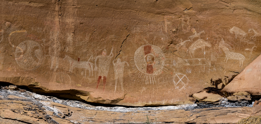
Mark’s sharp eyes spotted this very cool rock art panel on the cliff wall.
We were so thrilled to have made this “discovery” simply by heading down an inviting dirt road. A Jeep pulled up, and a woman got out and began telling us how excited she was to visit this spot and see the petroglyphs.
We realized that this is actually a known destination, remote as it is! We learned later that this spot, the Sego Canyon Rock Art area, is managed by the BLM (Bureau of Land Management). It turned out that this particular rock art panel was etched by the Ute people, probably between 1500 and 1880 AD.
The logic for archaeologists giving the etchings those dates is that there appear to be horses in this rock art panel yet horses didn’t arrive in North America until Christoper Columbus brought them here on his second voyage in 1493. At the other end of the date range, the Utes were moved onto reservations in the 1880s so they wouldn’t have been in this location after that.
We kept studying the cliff walls to see if there were more petroglyphs, and around the corner, we found another rock art panel. These petroglyphs were quite different than the others, much more clearly defined and more deeply etched into the rock face.

We found another rock art panel of petroglyphs nearby!
Again, the people were trapezoidal, but the etching was far more distinct and the people were wearing elaborate headdresses and jewelry and were depicted without arms or legs. It has been suggested that these figures resemble mummies.
Interestingly, to the right of the right-hand figure is another ghostly image with a similar shape but it isn’t outlined. Whether that was original or added later is hard to tell.

We learned later that this is presumed to have been created during the Fremont period.
Fremont rock art is considered to date from the first century through the 1300s.
There were some cloven hoofed bovines with long curved antlers near the people. Although these types of animal images are often labeled “big horn sheep,” to me they don’t look much like big horn sheep. Big horn sheep have shorter and very sharply curved horns and no tails per se. These animals (which are very common in Fremont rock art) seem more like ibexes to me — but ibexes aren’t native to this continent!
There are other critters in this panel that could be a beaver and a grouse.

.

We prowled around some more and came across a THIRD rock art panel that, again, was completely different than the other two!
We later learned that this third panel is from the Archaic Period which is estimated to be between 8000 BC and 1000 AD.
These are pictographs which are images rendered onto the rock with paint or dye. They are different than petroglyphs (the technique used to create the other two rock art panels) which were pecked out of the rock with a tool.
Considering how difficult it is for us in our current era to get house paint to last for twenty years, it is incredible that this dye has endured out in the elements and unprotected for thousands of years.

Ghostly figures of the Archaic Period (8000 BC to 1000 AD).
If the Ute and Fremont images with their odd looking humanoid shapes had been a little bizarre, this Archaic Period rock art panel was way out there! Also, for its age, it was the best preserved of the three. In fact, it seemed that the least durable rock art was the most recent work created by the Ute people just a few hundred years ago.
The Archaic Period images are more rounded and less angular, and the people have a very ghostly appearance with huge hollow eyes.
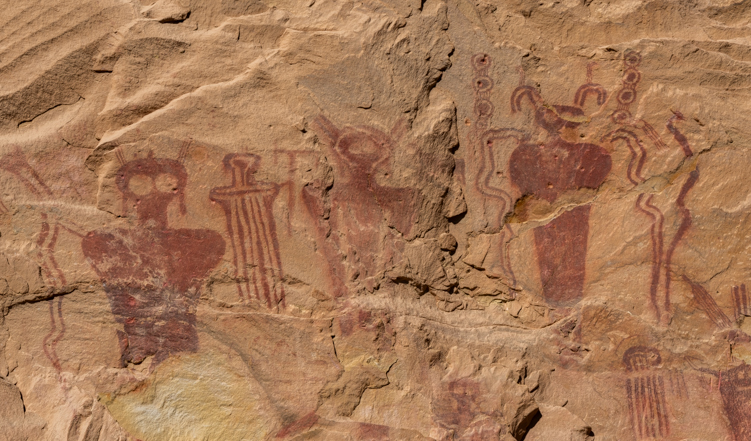
Otherworldly.

It turns out this particular rock art panel was etched by the Ute people, probably between 1500 and 1880 AD.

Odd things on its head.
It is intriguing that this one area inspired ancient peoples to make their mark on it across several millennia in very different styles. It’s impossible to know why they put their mark in this spot or what it depicted — especially the very odd humanoid figures — but it is fascinating to ponder.
The BLM is the most secretive of the government’s land management agencies. There are no big signs announcing the location of this special place, and it gets just a brief mention on their website. Like most of their incredible treasures, this spot remains as it always has been, totally unprotected.
Vandalism is a serious problem with every ancient site, however, and all the land management agencies have to deal with the trash that visitors leave behind as well as clean out the vault toilets and move that waste from those toilets to sewer treatment plants periodically.
The BLM often approaches all this with a sense of whimsy, and sometimes they post amusing signs reminding people to be considerate. In the vault toilet at this site we found a metal sign hanging on the wall above the toilet. It was complete with a pictograph person waving to grab our attention:

This sign was hanging on the wall inside the vault toilet.
Several dirt roads criss-cross this whole area and go in different directions. A few other people were out enjoying the beautiful day on their side-by-sides too.

The rugged dirt roads in this area are popular with ATVs and UTVs.
Our little trail scout, Buddy, wanted to show us the way to our next discovery.
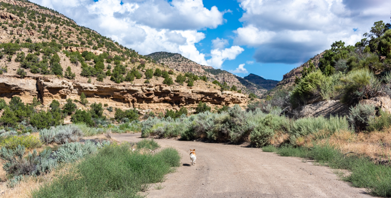
Buddy leads the way.
Before long, we noticed a structure off the side of the road. It was built very low and somewhat into a hillside. Perhaps it was an old root cellar. But who lived here — and when?

What is this??!!

We turned around and spotted a large and very well constructed building in the distance. What the heck?!

Oh my! Gotta check that out!
When we got closer we were impressed by the size of this structure. It had three large openings in the front that must have been windows. But what was it doing in the middle of nowhere down a rarely used dirt road?

This is a big, important and awfully well built building for such a remote place!
We later learned that there had been a coal mine back in here and a mining camp with homes and commercial buildings! Coal was first discovered in the area by rancher Harry Ballard, and it was very high grade. A hardware store owner named C.F. Bauer bought the property and formed the American Fuel Company and began developing the area in 1911.
In its heyday, there was not only the American Fuel Company Store (the building we saw), but a boarding house, some mining buildings and settlement homes all around.

The old American Fuel Company Store.
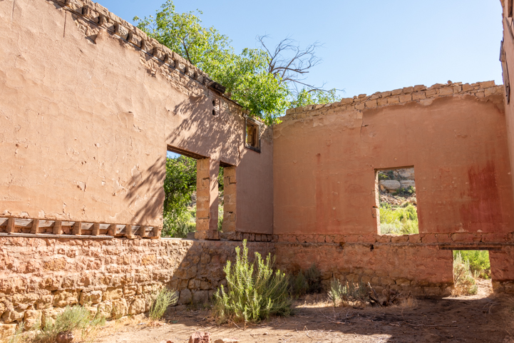
There had been a basement level and a main floor with high windows near the ceiling.
Inside the big building, plaster was peeling off the walls revealing the masonry work beneath. We’ve seen plenty of imitations of this effect in modern replicas of old buildings. How very cool to see the real thing!
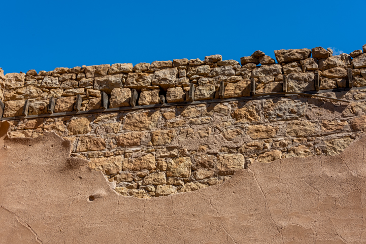
There was classic peeling plaster on the interior walls.
A short ways away there was another building in ruins. Behind it were the remains of a car. It looked to be a 1940s vintage car but we couldn’t determine anything about it, not even the make.

This ruin was nearby.

At one time, someone was thrilled to drive this home from the dealership.
Nearby we found a massive pile of wood. We later discovered that this was the old boarding house. It was still standing in 2011.

The boarding house was still standing in 2011 but is now just rubble on the ground.
We drove further on the dirt road and found another building. All these buildings were about a century old, but the masonry work was holding up pretty well.

Another solid building.


We could see the saw marks on the stones.
We came back to the trailer marveling at what we’d seen. At that point we had no idea what any of it was — it took some digging on the internet later to figure it all out.
But what a cool layering of history we found, all within a few miles. From far ancient times, possibly thousands of years BC, up to half a century ago, people lived and worked in this canyon.

The extraordinary breadth and depth of human history can be found even in a remote Utah canyon.
Who Were the Most Recent Inhabitants of Sego Canyon?
In 1914, the Denver and Rio Grande Western Railroad built a 5 mile long spur line from nearby Thomson to the mining camp, but the mine was never as profitable as hoped. The low water table made the mine inoperable at times, the trains had problems on the tracks, and a big investment in 1927 to obtain electricity from Columbia, Utah, 100 miles away all contributed to meager profits.
At its peak, the mine employed about 125 miners and there were 500 people living in the community around the general store building we’d seen. However, the mining company missed their payroll a bunch of times, paying the miners in scrip to use at the company store instead. Disgruntled, the miners joined the United Mine Workers Union in 1933 and they began being paid regularly.
It didn’t last, however. Employment dwindled to 27 miners by 1947. They pooled their money to buy the mine and had high hopes. Unfortunately, two years later, a fire destroyed the huge structure they used to load the coal into the rail cars, and then the train ceased operations.
When I-70 was built and came through about six miles south of the canyon in the 1970s, the mines closed and everyone left. A bitter blow came in 1973 when two carloads of treasure hunters showed up with metal detectors. They burned all the buildings and took whatever they could find in the smoldering ashes.
In 1994, Amtrak moved their passenger rail stop from Thompson Springs to Green River in 1994, and the town of Thompson Springs that had once connected Sego Canyon to the outside world withered away to just a handful of residents.
What a dizzying story this was to uncover. When we’d pulled off of I-70, we’d just hoped to see some cool cliffs up close!
But for us, that is the sheer joy of travel — accidentally bumping into unexpected gems!

.

Subscribe
Never miss a post — it’s free!
More info about Thompson Springs and Sego Canyon:
- History of Thompson Springs and Sego Canyon – Legends of America
- Rock art in Sego Canyon – Atlas Obscura
- Sego Canyon Rock Art Interpretive Site – Bureau of Land Management
- More about Thompson Springs – Architectural Afterlife and Only in Your State
- Location of Sego Canyon and Thompson Springs – Google Maps
Petroglyph and rock art sites we’ve found in our travels:
- Dinosaur National Monument, UT – More than fossilized dinosaur bones!
- Newspaper Rock Utah – Petroglyphs and Rock Art from the Ancients
- Oaxaca’s “Mitla Tour” – Ancient Zapotec Ruins & More!
- Saguaro National Park Petroglyphs – Tucson Mountains, AZ
- San Rafael Swell, UT – Pictographs & Dinosaur Prints
- Traces of Antiquity and the Not-So-Ancient in Utah!
- Yaxchilan and Bonampak – Haunting Ruins & Ancient Art in the Jungle

Other blog posts from Utah:
- “Healer of Angels” – The Eagle Whisperer – Martin Tyner of Southwest Wildlife Foundation
- A Back Roads RV Trip – AZ to NV to UT – Colorado River & Spanish Trail
- A Gateway to Utah’s Outback!
- A Utah Backcountry Adventure!
- Arches National Park Utah – A Playground of Soaring Red Rock Bridges!
- Bear Lake, UT – The Caribbean of the Rockies
- Bear Lake, Utah – A Turquoise Paradise in Snowy Mountains
- Best Friends Animal Sanctuary & Southwest Wildlife Foundation in Utah
- Bryce Canyon – Hiking The Rim & Navajo Loop + A Tourist Time-lapse!
- Bryce Canyon – Rainbow Point – Bristlecone Pines and Sweeping Vistas
- Bryce Canyon Gone Wild – Tempests, Rainbows & Wildlife
- Bryce Canyon in Winter – Snow and Lace on the Red Rock Spires!
- Bryce Canyon National Park – “Mossy Cave” – Mystery Waterfall!
- Bryce Canyon National Park – Fairyland Trail – A Beautiful Hike!
- Bryce Canyon National Park – Inspiration Point – OMG!
- Bryce Canyon, UT – Fairyland of Pink Turrets
- Canyon Country Highlights – Lake Powell, Horseshoe Bend & More!
- Canyonlands National Park UT – Island in the Sky (and Night Skies!)
- Canyonlands National Park Utah – Hiking in the Needles District!
- Capitol Reef National Park Utah – Awe-inspiring!
- Capitol Reef NP – Cathedral Valley – A Stunning Backcountry Drive in Utah!
- Casto Canyon Trail – A Delightful ATV / UTV Ride!
- Cedar Breaks National Monument – A Hidden Jewel in Utah
- Cedar Breaks National Monument – Glorious Amphitheater of Red Rocks!
- Cedar Breaks National Monument – Wild Skies & Summer Storms
- Cedar Breaks National Monument in Utah – Better Than Bryce?
- Cedar Breaks Wildflowers + Stunning Brian Head Overlook
- Coral Pink Sand Dunes State Park – Shape Shifting in the Sand!
- Dead Horse Point State Park, Utah – Magical Sunrises!
- Dinosaur National Monument, UT – More than fossilized dinosaur bones!
- Dixie National Forest Utah – Caves and Hikes
- Escapod Teardrop Trailers – Rugged Campers for Off-Road Adventure!
- Fish Lake Scenic Byway
- Fish Lake Utah – Alpine Beauty & Brilliant Stars in Dark Skies!
- Fish Lake Utah – Fun Things To Do in the Lakes and Mountains
- Fish Lake Utah – Wildlife and Aspen Groves
- Flaming Gorge Utah – Fiery canyons, a cool river, and nearly tame bighorn sheep
- Flaming Gorge Utah – Vibrant Hues
- Goblin Valley State Park Utah – One Gigantic Playground!
- Goblin Valley, UT – Where the Ghosts Are
- Grand Staircase Escalante Nat’l Monument – Lower Calf Creek Falls Hike
- Heavenly Theatrics in Utah’s Red Rocks
- Johnson Canyon Movie Set – A Spooky Ghost Town – Happy Halloween!
- Kanab – Hub for the National Parks + Gorgeous Canyons Nearby!
- Kanab & Alton, UT – Whoa!!!
- Kanab, Utah, 4th of July – Stars & Stripes in the Red Rocks!
- Logan Pass, Bear Lake, Mt. Nephi, & Cedar City, Utah
- Mexican Hat, Utah – A Special Hoodoo in the Red Rocks
- Mirror Lake Scenic Byway Utah – Fishing and Fun!
- Moab Utah – Red Rocks and Snowcapped Mountains
- Monument Valley & Hite Scenic Overlook – Stone Towers from Below & Above!
- Natural Bridges National Monument & Utah’s Bicentennial Highway
- Newspaper Rock Utah – Petroglyphs and Rock Art from the Ancients
- Panguitch, Utah – Little Britches & Big Horses in the City Park
- Paria Rimrocks “Toadstools” Hike to A Hidden Canyon!
- Parowan UT – Vermillion Castle and County Fair
- Provo Canyon & Alpine Loop Scenic Byways in Utah
- Red Canyon – Arches Trail – Windows & Hoodoos in Utah!
- Red Canyon Utah and the Bryce Canyon Bike Trail!
- Red Canyon Utah is an Overlooked Treasure
- San Rafael Swell, UT – Pictographs & Dinosaur Prints
- Sand Hollow Side-by-Side UTV/ATV Adventure Rally – Test Drives in the Dunes!
- Sand Hollow State Park, Utah – An Oasis in the Desert!
- SE Utah – A Mars Colony, Wide-Angle Photography & Snowy Mountains!
- Strawberry Reservoir, Utah – Springtime Beauty with Ice & Snow!
- The Burr Trail – A Fabulous Side Trip on Utah’s Scenic Byway 12
- The Day the Sheep Moved In!
- Traces of Antiquity and the Not-So-Ancient in Utah!
- Utah – Off the Beaten Path…then FURTHER Off the Beaten Path!
- Utah Back Roads – Lakeside RVing Near Salt Lake City
- Utah Scenic Byway 12 RV Trip – Driving An All American Road!
- Utah Scenic Byway 24 RV Trip – Capitol Reef National Park
- Valley of the Gods & Goosenecks State Park, Utah – Beautiful!
- Vernal, UT – Colorful Gateway to Dinosaur National Monument
- Wire Pass Trail – Slot Canyon Hiking!
- Zion National Park “West” RV Trip – Gorgeous Kolob Canyons!
- Zion National Park RV Trip – One AWESOME Canyon!
- Zion National Park’s Hidden Jewels – Off the Beaten Path in an RV!
- Zion NP, Kodachrome Basin & Snow Canyon, UT – Great Red Rocks!
Our most recent posts:
- How to Install Starlink Gen 3 in an RV? Use the Speedmount! 08/07/25
- Escape to Paradise – Rocky Mountain Magic! 08/01/25
- Is Forest River a Good RV? Well Built? Here’s Our Experience 06/20/25
- Sunset Crater Nat’l Monument – Lava & Camels at Bonito CG! 06/06/25
- 2024 Alpha Wolf 17CB Trailer – Our Goldilocks RV! 04/25/25
More of our Latest Posts are in the MENU.
New to this site?
Visit RVers Start Here to find where we keep all the good stuff. Also check out our COOL NEW GEAR STORE!! *** CLICK HERE *** to see it!
<-Previous || Next->

Wonderful work you Guys have done! Thanks again for sharing your experience with us.
Dave & Sherry
You are so welcome, Dave. Thank YOU for following our journeys all these years and appreciating our efforts online!!
I was looking for a stop over from Capital Reef NP to Denver in April and I think I found it thanks to your post! Looks like there is lots of BLM land in the area, so that’s great! I know you don’t normally divulge coordinates, but would be thrilled with some dry camping suggestions.
Regardless, happy travels, and thanks for your amazing pictures and posts!
This would make a great stopover, Leonard. There is a lot to see in the canyon, and the town of Thompson Springs is interesting and thought-provoking too. There’s plenty of BLM land in the area, so have fun scouting it out and finding a place that makes the ideal campsite for your needs!
What a neat story you came across. That is such a beautiful area of Utah, and close to where I-70 cuts through the San Rafael Swell. A modern feat of engineering if ever there was one. The whole drive along that interstate is one breathtaking view after another. Thanks for the post.
“Breathtaking” is the word for sure, David. I was taking photos the whole way! That part of I-70 is definitely a phenomenal engineering feat, and the San Rafael Swell is extraordinary. We were very fortunate to bump into such a special story…and I’m sure there are many others hidden away there too! Hopefully we’ll visit again soon and can bring back more goodies to share!
How cool you were able to go off road to see this. When we were here it was 2014 before our side by side. We couldn’t explore so we moved on. Glad to know it will definitely be on the list! Great research you found. 👍🏻
It’s beautiful side-by-side country, Annie, and the roads continued far beyond what we saw. I hope you get back there with your side-by-side and enjoy it as much as we did!
Love this one! I always enjoy it so much when history creeps in to an adventure. Thanks for sharing!
I’m so happy this resonated with you, Jeff (and crew!). The creep-in of history was extra special because we had no idea what we were looking at when we were there, but the clues kept showing up all around us! Buddy would have loved to share Trail Scout duties with Sweetie and Gracie…!
Another great story about a long gone town and area of America we didn’t know about. You really know how to dig for interesting information too! Thanks for this little tidbit of history.
You’re welcome, Pete. It was such a great feeling of discovery to come across this place! We were mystified at first but so fascinated later to find out it was home not only to the ancients but to a recently vanished community as well. History came alive!
“Uncovering history”….unexpected discoveries around every bend – Buddy in the lead!!!!
Love, Mom
So much fun…especially with Buddy sniffing out the best places!
Love it! Thanks for sharing the story.
You’re welcome, Debbie. Merry Christmas!