Mirror Lake Scenic Byway Utah – Fishing and Fun!

Early July, 2012 – After exploring the pretty Provo Canyon and Alpine Loop Scenic Byways we set our sights on another one of Utah’s beautiful drives, the Mirror Lake Scenic Byway.

This road climbs into the mountains on the way out of northern Utah, pausing at a spectacular summit
before plunging into southern Wyoming.

As it winds through the peaks it takes several sweeping curves between the many alpine lakes.

We parked the buggy in a nice secluded spot in the woods and soon discovered that the sound of rushing water we heard was a huge waterfall that was just a little ways down a narrow trail from the rig.  What a find!  Wildflowers were growing along the water’s edge, and we spent many happy hours among them, marveling at the endless flow of crashing water.

During our stay we hiked to several of the lakes in the area, finding each a little different and pretty in its own way.  The Byway’s namesake Mirror Lake was a hubbub of activity on the Sunday afternoon we visited.

Fishermen lined the banks and kids played on the shore.  The water was filled with floating craft of all kinds, from kayaks to inflatable boats, and despite the many people on the trails and in the water there was a serenity to this lake that was infinitely appealing.

We enjoyed a few blissful days in these alpine lakes and then made our way off the mountain to Evanston, Wyoming.

Criss-crossing the Utah and Wyoming state borders in this area, we continued north towards Utah’s beautiful Bear Lake.  The nickname for this lake is “The Caribbean of the Rockies” and we soon knew why.


<- Previous                                                                                                                                                                                       Next ->

Provo Canyon & Alpine Loop Scenic Byways in Utah

Cows greet us in the morning in Thistle, Utah.

Cows greet us in the morning in

Thistle, Utah.

The Wood Hollow Fire creats an amazing sunset.

The Wood Hollow Fire

creates an amazing sunset.

Wood Hollow Fire Bridal Veil Falls, Provo Canyon, Utah.

Bridal Veil Falls, Provo

Canyon, Utah.

Bridal Veil Falls, Provo Canyon, Utah.

Bridal Veil Falls.

Bridal Veil Falls, Provo Canyon, Utah. South Fork Park, Provo Canyon, Utah. Provo Canyon is a great spot for cycling.

Provo Canyon is a great spot for cycling.

Heber Valley Railroad at Vivian Park.

Heber Valley Railroad.

Heber Valley Railroad at Vivian Park.

They said they like their jobs!

Provo River Parkway, Provo Canyon, Utah.

Provo River Parkway.

Provo River Parkway, Provo Canyon, Utah.

Provo River Parkway.

Cool bike rack.

Cool bike rack.

Waterlilies, Provo Canyon, Utah.

Waterlilies

Water play.

Alpine Loop Scenic Bywa, Utah.

Alpine Loop Scenic Byway.

Chair lifts at Sundance Resort, Utah.

Chair lifts at Sundance.

Downhillers & their bikes get a ride up at Sundance Resort, Utah.

Downhillers & their bikes get a ride up.

Wildflowers, Sundance Resort, Utah. Flowers, Sundance Resort, Utah. Wildflowers on the Alpine Loop Scenic Byway (American Fork), Utah. Wildflowers on the Alpine Loop Scenic Byway (American Fork), Utah. On break from shoot-em-up birthday entertainment at Sundance Resort, Utah.

On break from shoot-em-up birthday

entertainment.

Alpine Loop Scenic Byway, Utah.

Another wildfire.

Wildflowers on the Alpine Loop Scenic Byway (American Fork), Utah. Wildflowers on the Alpine Loop Scenic Byway (American Fork), Utah. Cascade Spring on the Alpine Loop Scenic Byway, Utah.

Cascade Spring on the Alpine Loop

Scenic Byway.

Ahhh….!

Wildflowers on the Alpine Loop Scenic Byway (American Fork), Utah. Wildflowers on the Alpine Loop Scenic Byway (American Fork), Utah.

Provo Canyon Scenic Byway & Alpine Loop Scenic Byway, Utah

Late June, 2012 - We continued our travels north from Fish Lake, Utah with "scenic byways"

on our minds.  We had enjoyed many officially designated "scenic roads" in our travels this

season, and were ready for more -- and the Utah map seemed to be filled with them.  Little did

we know that the "Energy Loop" up Eccles Canyon from Fairview starts with an 8% climb for 8

non-stop miles on a skinny winding road with a steep drop off and no guardrail.

Oops!! The truck struggled mightily, Mark's

knuckles turned white, and I nervously

glanced at the map wondering when the

road would flatten out.  It never did.

At the 6 mile mark we finally spotted

a large pullout and we stopped to let

the truck catch its breath.  Another

truck towing a horse trailer stopped

with us for the same reason, and

the driver assured us there was

great boondocking up top, after just

a few more miles of 8% climbing.  It

sounded tempting, but before I

knew it Mark had headed the buggy straight downhill off

that mountain.  So much for that scenic drive!

At tiny Thistle, Utah, we got a visit at our trailer from a herd of

friendly cows the next morning.  By late afternoon a wildfire had

started in the distant mountains.  It made for a spectacular

sunset, but soon became a devastating blaze.  Within the next

few days it consumed nearly 75 square miles, killed a man, and

destroyed 52 homes.  We later learned it was caused by arcing

power lines that had been laid bare by a thief who stole the

protective copper wire from the poles, although officials said the

power surge was likely too great for even those protections, had

they been in place.

Moving north, we thought the Provo Canyon Scenic Byway looked

promising and ventured that way.  The road was under

construction, but the heavy traffic didn't detract one bit from lovely

Bridal Veil Falls.  Kids played in the pools at the bottom of the falls

while lovers embraced and posed for cameras part way up.  It looked

like a great spot to get engaged and start planning

for that wedding dress and bridal veil.

As we drove we noticed a paved bike path was

accompanying us, and the next day we took a

bike ride along the Provo River Parkway.  It starts

at Vivian Park, and just as we got onto the bike

trail the Heber Valley Railroad train showed up (check out the gorgeous photos at http://

hebervalleyrr.org).  It was on its daily excursion from Heber City, bringing tourists past the mountain/

lake views across Duck Creek Reservoir and through glacier carved Provo Canyon to Vivian Park.

The bike path winds

alongside Provo River

between towering

cliffs.  It is beautifully

constructed with three lanes,

allowing for two directions of

bike traffic and one lane of

foot traffic.

Despite being mid-week the

trail was quite busy all the

way to town.  When we got

into Provo we noticed a

clever bike-shaped bike

rack standing outside one

business.  Another

business had beautiful

landscaping with a huge

lilly pond right out front.  It

was filled with blooming

waterlilies of all colors.

Getting further into the city we

found the entire toddler set from

town was cooling off in the

fountains at the mall.  It was perfect

summertime fun.

As I mentioned, this area is ripe with scenic

drives, and our map highlighted the Alpine

Loop Scenic Byway forking off from Provo

Canyon.  This time we went without the trailer

in tow, and that was the right way to go.  The

road climbed and snaked towards snow-

capped peaks, passing by Robert Redford's

famous ski retreat, Sundance Resort.

What a thrill to see snow-capped mountains!

The snow wasn't thick like last year, we

were told, because of light snows over the

winter, but it was very pretty.  Families

packed themselves into the wide chair lifts

to the tops of the mountains, while downhill

bikers sent their bikes up ahead of them

and followed a few chairs behind.  Those

guys have guts -- the mountains were very

steep!

Wildflowers and landscaped flowers were

in bloom all over the place, and we

entertained ourselves for quite some time

taking photos of their smiling faces.

We hunted around for

"Bob" but he wasn't at his

resort that day.  However, one lucky fellow was celebrating his 70th

birthday by hosting his entire extended family for a long weekend of

fun and entertainment at Sundance.  We met up with two actors who

were on break between the birthday boy's afternoon and

evening entertainment shows. They were dressed to the

nines for a cowboy shoot-em-up.  Stepping out of character

for a few minutes, they told us they had lived and worked

around the resort for ages and had never gotten a glimpse of

"Bob" either.

Continuing on the Alpine Loop Scenic Byway, we

wound up and down on curvy roads through heavy

forests and out onto mountain ridges with wonderful

views.  Wildfires were engulfing all of the west, it

seemed, and another one burned in the distance.

A spur road took us to Cascade Springs where

thickets of wildflowers grew in clumps along the

peaceful banks of a brook.

The water was just too cool and clear to resist, and at

the end of our sweaty hike Mark commented that he

was going to get a bath in the stream.  Mid-laugh I

realized he wasn't joking as I watched him throwing cold

water over his head.

We had gotten a delicious taste of Utah's

alpine forests and snow-capped peaks.

Our next scenic drive along the

Mirror Lake Scenic Byway would take us to

Utah's alpine lakes.


Canyon de Chelly, AZ – A Canyon of Indian Cliff Dwellings

RV blog post - We took the scenic route through Arizona's Navajo Nation to Window Rock and saw the stunning vistas and cliff dwellings of Canyon de Chelly.

Window Rock City Park.

Window Rock, Arizona.

The Window.

The Navajo Tribal Band practices for Oklahoma's Red Earth festival at Window Rock.

The Navajo Tribal Band practices

for Oklahoma's Red Earth festival.

The Navajo Tribal Band practices for Oklahoma's Red Earth festival at Window Rock. Navajo Code Talker statue at Window Rock, Arizona.

Navajo Code Talker.

Show of patriotism at a cemetery outside Window Rock on Indian Route 12, Arizona. Views along Indian Route 12, Arizona.

Scenic Indian Route 12.

Exotic rock formations and colors along Indian Route 12, Arizona.

Two toned rock formations.

Brilliant rock formations along Indian Route 12, Arizona.

A homeowner with a flair for color.

All kinds of colors in the rocks along Indian Route 12, Arizona.

The land was painted pink too!

Cliff views at Canyon de Chelly National Park, Arizona..

Looking down Canyon del Muerto.

Looking down Canyon del Muerto at Canyon de Chelly National Park, Arizona..

Sheer cliffs and lush valleys.

"Where two fell off."

Massacre Cave at Canyon de Chelly National Park, Arizona..

Massacre Cave.

Cave dwelling at Canyon de Chelly National Park, Arizona..

The little cave to the left.

Cliff dwelling at Canyon de Chelly National Park, Arizona.

There's a structure inside!

Expansive views at Chelly National Park, Arizona.

The immensity is hard to capture.

Looking across the canyon at Mummy Cave, Chelly National Park, Arizona.

Tim & Mary Lynn look across at Mummy Cave.

Mummy Cave, Chelly National Park, Arizona.

Mummy Cave housed a small community

in the shadows.

Building inside Mummy Cave, Chelly National Park, Arizona.

The structure inside Mummy Cave.

Navajo Fortress between Canyon del Muerto and Black Rock Canyon, Chelly National Park, Arizona.

The confluence of Canyon del Muerto

and Black Rock Canyon.

Antelope House, Chelly National Park, Arizona.

Antelope House is tucked into the

bottom of this massive cliff.

Close-up of Antelope House, Chelly National Park, Arizona.

Close-up of Antelope House ruins.

Hiking down to White House Ruin, Chelly National Park, Arizona.

Beginning our descent

into Canyon de Chelly.

We hike to White House Ruin, Chelly National Park, Arizona.

Looking down on the lush valley floor.

We hike past crazy swirling rock patterns on our way to White House Ruin, Chelly National Park, Arizona.

Crazy swirling rock patterns.

Rock swirls dwarf the trees on our hike to White House Ruin, Chelly National Park, Arizona.

The swirls dwarf the trees in the middle of the pattern.

Pause in our hike to White House ruin, Chelly National Park, Arizona.

We take a breather from hiking.

The lush valley floor of Canyon del Chelly.

The bottom of the canyon is flat and wide.

White House Ruin, two levels of dwellings, Chelly National Park, Arizona.

White House ruin has two levels:

a ground-level building & a cave dwelling above.

Dramatic pink and orange stripes decorate the front of White House Ruin, Chelly National Park, Arizona.

No architect today could design a

more dramatic front entrance!

Awe-inspiring drippy stripes on the cliffs surround White House Ruin, Chelly National Park, Arizona.

The drippy stripes down the walls

fascinated us.

Wildflowers, Chelly National Park, Arizona.

Flower or origamy?

Wildflowers, Chelly National Park, Arizona. Pictographs, Chelly National Park, Arizona: a person and a roadrunner.

Rock Art:  Roadrunner.

Pictographs at Chelly National Park, Arizona: a scorpion.

Rock Art:  Scorpion.

A hogan stands agains a dramatic backdrop of cliff walls on the lush valley floor of Chelly National Park, Arizona.

A Navajo hogan backed by dramatic cliff walls.

We hike through a tunnel on the White House Ruin hike in Chelly National Park, Arizona.

Canyon de Chelly National Park, Arizona

Early June, 2012 -- Leaving the Petrified Forest, we decided to head north by

Indian Route 12 which, to our surprise, was noted on our tourist map as a

scenic route.  As one-time Arizona residents we had no idea there was a

scenic road through the Navajo Nation way over in the northeastern corner of

the state.  We also wanted to see Window Rock, which lies on that road.  This

town is the Navajo tribal headquarters, and it always turns up in the Phoenix

TV weather forecasts with very cool temps.

We arrived on a warm day, however, and

were immediately drawn to the city park in

front of the big window in the rock.

The tribal band was practicing in

the park, and we watched and

listened for a while.  Chatting with

the band leader during a break,

we found out the band was

headed to Oklahoma City in a

few days for the big Red Earth

arts festival there.  Apparently

this is one of the largest

gatherings of Indian artists and

performers in the country, and

the group was very excited.

The park also features a large

sculpture of a WWII "code talker" in action on his radio.  A nearby plaque

explains how the US Military was struggling to find a way to keep the

Japanese from deciphering their communications in the South Pacific

Theater, and that 29 Navajo marines were recruited to devise a new

code using their native language.  By war's end there were over 400

Navajo Marines serving as code talkers, and the Marine Corps

commanders credited them with saving countless American lives.

Maj. Howard Conner, Signal Officer on Iwo Jima, is quoted as saying,

"Were it not for the Navajos, the Marines would not have taken Iwo Jima."

This impressive history is also the subject of a fictional 2002 movie,

Windtalkers.

Back on Route 12 we saw more patriotism in a cemetery festively filled

with American flags.

The scenery on our route became very dramatic as we drove north of

Window Rock.  Huge red rock cliffs lined the sides of the road.

Suddenly it seemed that God switched paints on his easel, and large

rock formations began to cover the landscape in shades of green as

well as red.

Someone with an artistic eye painted their house a vivid blue,

making a wonderful contrast to the green and red rocks in their

back yard

In one place the

sandstone even had a

pink hue.  It was a

beautiful drive.

Our destination was

Canyon de Chelly

National Park

(pronounced "d'Shay").

This park is at the confluence of three

snaking canyons that are like three fingers of

a hand spreading eastward from where they

all join in the town of Chinle ("pronounced

Chinley").

The stunning thing about Canyon de Chelly

is the immensity of the canyons.  Standing on

cliffs that are 1,000' above the canyon floor,

the walls are very sheer and the views curve

past narrow walls of stone.  At the bottom of

the canyon is a lush, fertile valley floor where

the Navajo developed corn fields and peach

orchards in the 18th and 19th centuries.

In the movies, landscapes like this are always accompanied by the piercing call of a

falcon echoing off the canyon walls.  But here the silence was so noticeable that our ears

hurt.  Scanning the horizon many miles distant, and looking deep into the valley below

us, the only sound was our own breathing.  Even the wind stood still.

In 1805 the Spanish tried to conquer the Navajos.  At the point where I was standing a woman

tried to fend off a Spanish soldier, and in their struggle the two fell off the cliff to their deaths.  In

the distance we could see "Massacre Cave" where the Navajos had hidden out.  In the end, the

Spanish claimed to have killed 90 men and 25 women and children, but the Navajo remember it

differently, saying that all the younger men were out hunting that day and the deaths were strictly

women, children and old men.

Either way, the cave looked tiny in

the distance.  Inside were some

structures that the Navajo hid in.

To the left of the main cave was a

much smaller one and, using the

long camera lens, we could see

another small structure inside there

as well.  It is hard to imagine living

on the edge of a cliff like that for any period of time,

especially with the Spanish after you.

At each viewpoint you get a slightly different view of these

lush canyons, and it was hard to capture the enormity of

the place in a little photograph.  Pan out or zoom in?  How

do you show it all??

At the Mummy Cave overlook we came across a

couple sitting behind a tripod. They were waiting

patiently for the afternoon light to provide its best

illumination of the cave ruins far below.  Waiting

for good light sounded like a great idea, so we hung out and

started chatting with them.  It turned out that they had spent the

last three years traveling the western states in their camper van, living

a lot like we do by boondocking on public lands.

Our eyebrows shot up when they told us they had just come back

from a sailboat charter in the Grenadines in the Caribbean ten days

earlier and were contemplating taking their travels to the sea.  What's

more, we found out Tim's mountain bike on the back of their van was

the same exact model as Mark's on the back of our trailer.  To top it

off, Mary Lynn enjoyed web design too.  What a crazy coincidence!!

Like us, too, they were using a Nikon camera to try to capture this cliff

dwelling in just the right light!

The good light never came, but we managed a few shots

anyways and hoped we'd run into these guys again somewhere.

Meanwhile, the mystery of the cliff dwellings lured us on.  The ancients built their homes in caves on these sheer

canyon cliffs between 700 and 1300 AD.  So these homes were first going up right after the peak of Mayan

remodeling down in Palenque in Chiapas, Mexico.  They may not be as majestic in terms of size or human

construction and engineering skills, but they are incredible for making fantastic use of the landscape.  What a

place to build a house!

Over at Antelope House we looked out across the canyon

at a beautifully striped, back-sloping wall.  Nestled at its

base was a small town made up of crumbling walls,

windows and towers.  You need binoculars or a long

telephoto lens to make out the tiny structures so far

below.  Even then they look like little toy buildings for wee

dolls.  They can't possibly be real.

Archaeologists call these ancient people the Anasazi,

which is derived from the Navajo language and is

variously translated as "Ancient Ones" and "Enemy

Ancestors," due to the subtle word "Zazi" which means

"Non-Navajo" or "enemy."  Also known as the Ancient Puebloans,

from the Spanish word for "townspeople," these long ago people

farmed the valley floor and disappeared around 1300, probably due

to drought.  The Navajo didn't arrive in this area until 1600, and by

then the ruins were long abandoned.

The Navajo flourished here for a while, but in 1864 US Col. Kit

Carson entered the canyon with a group of soldiers and

eventually cornered the Navajo at one end.  Few survived, and

those that did were forced to walk 300 miles to Fort Sumner in

New Mexico and stand trial.  They were allowed to return five

years later.

The most famous of the

ruins is "White House

Ruin," and we decided to

hike down into the

canyon to see it up close.

We hiked along with our

new RVing/sailing friends

who had ended up

camping alongside us overnight.  As with every overlook in the entire

park, the views from the top were so gorgeous I found myself running

and jumping over the rocks trying to get the best angles and trying to

fit it all into the camera frame.  Sigh.  Not possible!

The contours of the rocks are

wavy and rippled, swirling in

enormous and wild patterns.

You can almost feel the power of

the water that etched out its

course along these canyon walls

over the millennia, carving its

path ever deeper into the stone.

After snaking down the edge of the rock face,

we finally arrived at the canyon floor, crossed a

small foot bridge, and arrived face-to-face with

White House Ruin.

Two levels of dwellings were built into the base of the cliff -- one

on the ground level and another one up about 40' off the ground in

a cave.  An orange rainbow of stripes rains down the cliff wall,

painted by a divinely inspired hand -- or the result of a spilled paint

can way up on the top of the canyon.

At our feet we discovered unusual

flowers.  A young Navajo boy showed us

a lovely painting he was working on

featuring the White House ruin and some

of the rock art that we could barely make

out along the rock wall.

In no time at all we climbed back to the top, passing through a wonderful

tunnel on the way.  We would have stayed to see a few more of the

sights this mysterious canyon has to offer, but a massive heatwave was

spreading across the west and we wanted to get to higher, cooler

ground.  We seemed to be on an ancient ruin kick, something we had

started with the Zapotecs and Mayans in southern Mexico several

months back.  So we made our way to Mesa Verde National Park in

Colorado, possibly the best collection of cliff dwellings in the US.


Fish Lake Utah – Wildlife and Aspen Groves

In mid-June we visited Fish Lake, Utah, and drove the pretty Fish Lake Scenic Byway where we saw lots of wildlife and later learned the story behind Five Wives Vodka. RV boondocking is all about spectacular views and space to spread out.

It was a tight squeeze to get here…but oh, was it worth it!

Sometimes driving the fifh wheel down dirt roads breaks stuff in the trailer.

Mark fixes a light fixture.

Mother duck and ducklings on Koosharem Reservoir, Utah.

Mama duck & ducklings.

Seagulls fishing on Koosharem Reservoir, Utah.

Seagulls fished every afternoon.

A hummingbird sits on my bike's derailleur cable.

A hummingbird guards "his" feeder.

Pelicans floating on Koosharem Reservoir, Utah.

Little white pelican boats float past.

One way to walk your dog.

The easy way to walk your dog...

Dog bounding through tall grasses at Koosharem Reservoir, Utah.

…the dog's gotta run to keep up!

Bunny relaxing in the shade.

Relaxing in the shade of the trailer...

Cows watch our every move.

Cows stop what they're doing to study us as we ride past.

RV boondocking offers stunning views and privacy.

An idyllic setting.

Road to Richfield Utah goes over red rock mountains.

Red rock mountains encircle green farmland.

Richfield Utah is green farmland tucked between red rock mountains. Magazine rack in Richfield Utah.

Happy rural living.

Scowcroft Never Rip Overalls mural on the wall of Grass Valley Mercantile Company in Koosharem Utah.

The Grass Valley Mercantile Company.

Inside the Grass Valley Mercantile Co. Koosharem, Utah.

Inside the Mercantile.

Salt Lake Randonneurs on a 250-mile one-day bike ride

These guys were 93 miles into a 250-mile daytrip.

Fish Lake Scenic Byway, Utah.

Fish Lake Scenic Byway.

Fish Lake Lodge, Utah.

The deck of Fish Lake Lodge overlooks the lake.

Fish Lake seen through aspens, Utah.

Fish Lake through the aspens.

Cool staircase outside Fish Lake Lodge, Utah.

A creative banister on the deck stairs.

Wildflowers in Fish Lake, Utah.

Wildflowers!

Elk head on the wall of Fish Lake Lodge, Utah. Cozy fireplace and log rocking chairs at Fish Lake Lodge, Utah.

The fireplace.

Carving up the day's catch at Fish Lake - ugh!

"Ooh - fish guts - Yuck!!"

Carving up the day's catch at Fish Lake - cool!

"Cool, dad!!"

Old Spanish Trail, Fish Lake, Utah.

The Old Spanish Trail...memorialized.

Fish Lake Scenic Byway, Utah.

Fish Lake Scenic Byway.

Butterfly.

Butterflies and moths were everywhere.

The Mormon Temple in Manti, Utah.

The Mormon Temple in Manti.

Liquor outlet store, Utah.

Liquor is sold only in special places.

Free the Five Wives t-shirt.

Free the Five Wives!!

Five Wives vodka bottle.

The culprit.

Koosharem and the Fish Lake Scenic Byway, Utah

Mid-June, 2012 - Searing heat chased us out of the brilliant red rocks of Capitol Reef National

Park, Utah, and we were glad to see the landscape cool to soft green rolling hills as we traveled

north.  Searching for a scenic place to put the fifth wheel, we wriggled down a narrow dirt road,

squeezed the big rig between some very thick bushes, and finally emerged onto a perfect

shoreside spot on the edge of the Koosharem Reservoir.  What a view!

Of course, taking a 52' long rig down a rutted dirt

road can wreak havoc inside

the trailer, and Mark had to JB

Weld one of the light fixtures

back together again.

What a beautiful contrast the

blues and greens of this place

were to the rugged red rock

cliffs of Capitol Reef just 50

miles south of us.  Wildlife was

everywhere.  Raucous seagulls

went fishing right outside our door

every morning and evening, and a

mother duck cruised by every sunset with her

brood in tow.

Hummingbirds discovered our feeder minutes

after we put it out, and one took up residence

on the derailleur cable of my bike, jealously

guarding the feeder from a distance.

Life was very relaxed on this little lake.

Cormorants would surface from fishing

underwater every so often, and in the late

afternoons the pelicans would float by like

little white boats.

Just as regularly, a neighboring RVer

would zoom past on his motorbike while

his dog bounded eagerly behind.

One afternoon we found a rabbit lounging in the trailer's shadow looking very much

like he owned the place.

The lake was surrounded by pastures filled

with cattle and sheep.  When we rode our

bikes around the lake the cows all stopped

what they were doing and stared at us

intently as if they had never seen a bike

before.

There was a peaceful serenity here.

One morning we headed over the hills to the towns of

Richfield and Koosharem.  Red rocks revealed

themselves once again on our drive, and the valley

stretched like a vast green sea of farmland between the

mountains.

We had been visiting national parks for the last month,

going from one tourist destination to the next.  But this

was down home farm country.  When we parked at the

supermarket it was quite a change to slide in between

two trailers, one carrying irrigation equipment and the

other one filled with sheep.

Peering through

the slats of the

sheep trailer I

spotted a face that was fluffy and white with dark eyes but was definitely not a sheep.

"That's a Great Pyrenees Mountain Dog," the farmer said as he walked over to me.

"He lives with the sheep all the time and guards them."  Sure enough, he looked very

contented in the trailer with all his sheep buddies surrounding him.

We got another

reminder of the rural

nature of this area

when we scanned

the magazine rack in

the supermarket and

saw "Chickens

Magazine" standing

front and center.  It featured

an article on how best to

catch and hold a hen.  All the

outdoorsy joys of rural living

were highlighted on this

magazine rack:  right behind

Chickens were Hunting

Illustrated, The

Backwoodsman, Rifle's Varmint Magazine, Trophy Hunter, Bow & Arrow, Fly Rod & Reel,

Illustrated Horse Magazine and The New Pioneer.

Over in the tiny town of Koosharem, the Grass Valley Mercantile Company has been the local

variety store for eons.  The mural on the outside of the building advertised "Never Rip

Overalls" by Scowcroft, a brand of pants we learned later were made in Utah in the early part

of the last century.  They were known for their ruggedness right up until the last pair was

produced in 1937.  There was a comforting air of antiquity here.

On our way into town

we had followed several

groups of cyclists,

including a pair on

recumbent bikes.  We

caught up with

Katherine of the Salt

Lake Randonneurs at

the Mercantile.

Between gulps of V8

juice she explained that

she and her companion

were 93 miles into a 250 mile bike

ride that day.  The kicker was that the

group of cyclists was doing all those

miles in just one day and night.  Yikes!

Another day we drove the Fish Lake

Scenic Byway, one of Utah's many

beautiful highways and byways that are

officially (and rightfully) designated as

"scenic."  This road weaves and curves

through pine tree studded hills and into

thick aspen groves.

A bike trail runs alongside the lake and

we found ourselves jumping on and off

our bikes to take in the views and check out the

wildflowers.

Fish Lake Lodge is the centerpiece of

the whole Fish Lake community. 

It's a wonderful log building filled with

trophy heads with a large dining room

that looks out over the lake.

We were there in the summertime, but the fireplace

looked ideal for snowy winter evenings too.

Of course the main activity at Fish Lake is fishing,

and it seemed everyone we saw was carrying a

fishing pole, a tackle box and other specialized

fishing tools. Melton Tackle seems to be a good

brand for a great day of fishing.

A large family huddled around one of the fish

cleaning stations near the Lodge, and two men

busily carved up the day's catch. The kids watched

in fascination as one of the men sliced open the

belly of a fish and then explained it was a female

as he pulled out a fistful of eggs!

The little girl scrunched up her face and squealed

“Gross!” while the little boy next to her grinned,

"That's cool, Dad!”

The Fish Lake Scenic Drive lived up to its billing and was very pretty.  People have

traveled through this area for a long time.  It was first inhabited by mammoth hunters

some 9,000 years ago, and part of the Old Spanish Trail, used by Utes and cowboys

alike, wanders along the western side of the lake.  Out of the corner of our eyes we

both thought we spotted a train of horseback riders, but on second glance we saw it

was a memorial sculpture in the middle of a field commemorating the Utes and settlers

who traversed the Old Spanish Trail.

Notes from Kit Carson in

1848 described the shallow

streams in the area as

"swarming with fish."  Using

just "an old bayonet

fastened to a stick" he

caught five dozen fish at sunrise in the icy water.

We didn't see quite such plentiful fish, but we found

the flower-strewn banks of the lake and streams

teeming with butterflies.

The rolling hills around Fish Lake got us thinking

about the bigger mountains up north, and we soon

packed up the rig and journeyed a little further down

the road.  Utah is home to many devout Mormons,

and the temple in the small town of Manti was

quite a sight to see out the truck window.

The flip side of such piousness is that liquor is

rather hard to find.  The small towns we

passed through didn't sell beer at the grocery

stores.  To satisfy that kind of wayward vice

you had to go down to the gas station or to a

liquor outlet store.

We felt quite sinful when we ducked into one of these small outlets on the edge of

town, and we guiltily glanced over our shoulders to see if anyone was watching us as

we slipped through the door.

Another unusual side to the Mormons' straight-laced style of Christianity is the dubious

history these fine people have with polygamy.  The practice was abandoned long ago

by mainstream Mormons, but the idea of it still raises eyebrows among non-Mormons

today.  So it was with a slight smirk that we heard the story behind a t-shirt hanging on

the wall which showed five jailed women in vintage garb above the words.  "Free the

Five Wives."

Apparently a Utah distillery recently created a delicious new vodka which they named

"Five Wives Vodka."  Its popularity soared when the distributors over in Idaho refused

to carry it because they found the name insulting to the faithful.  This ban resulted in

an outcry among vodka lovers on both sides of the border.  T-shirts demanding that

the Five Wives be let out of jail were printed up and they sold like mad.  Naturally we

had to pick up a bottle of the stuff, as we have both really enjoyed the Wasatch

Brewing Company's beer called "Polygamy Porter" which, ironically, has always been

sold freely and never been banned anywhere!

Happily toasting Utah's incredible beauty, we left Koosharem in pursuit of the pretty

scenery and great bike rides found along the Scenic Byways of Provo Canyon and its Alpine Loop.


Capitol Reef National Park Utah – Awe-inspiring!

Capitol Reef National Park captivated us with its natural afternoon light show at Sunset Point, its Mormon history at the Pioneer Register and the natural rock Hickman Bridge. Capitol Reef National Park: Sunset Point. Vivid colors come to life at Capitol Reef National Park: Sunset Point.

Vivid colors come to life.

Capitol Reef's Sunset Point is a romantic spot for taking photos. Sunset Point at Capitol Reef National Park.

Mark disappears in the vast landscape.

Evening shadows at Sunset Point Trail, Capitol Reef Nat'l Monument.

Late afternoon shadow-play at Sunset Point.

Evening shadows at Sunset Point Trail, Capitol Reef Nat'l Monument. Twisted trees resemble driftwood on an inlad vermillion sea.

Twisted trees resemble driftwood on

an inlad vermillion sea.

We were way too excited to sit down!

Utah wildfire smolders int the distance.

A wildfire puffs smoke in the distance.

Spectacular views along Capitol Reef's

Views along the park's "Scenic Drive"

An antique plough sits out in a field.

An antique plough sits out in a field.

Pioneer Schoolhouse at Capitol Reef.

Pioneer Schoolhouse

The Capitol Gorge wash where pioneers arrived by car.

...and now.

Capitol Gorge Wash then...

It must have been exciting to

arrive here.

Pioneer Register, Capitol Reef National Park.

Hiking to the Pioneer Register.

Pioneer Register, Capitol Reef National Park.

Pioneer names from September

24th, 1910.

M. Larson, Nov. 20th, 1888

M. Larson, Nov. 20th, 1888

Wildflowers soften the canyon walls.

Views from the Golden Throne Hike at Capitol Reef Nat'l Park

Looking down from our hike to

the Golden Throne

Gnarled trees on the Golden Throne hike.

Gnarled trees on the Golden

Throne hike.

End of Trail.  And there's the Golden Throne.

End of Trail.  And there's the Golden Throne.

Views from Capitol Reef's

Views from the park's "Scenic Drive"

The setting sun plays with light and shadow on the rocks at Capitol Reef, Utah.

The setting sun plays with light and shadow on the rocks.

Gifford Homestead Barn, Fruita, Utah.

Gifford Homestead Barn

Horse grazing at Gifford Homestead.

Not a bad spot to graze.

Hickman Bridge at Capitol Reef NP

Hickman Bridge

Mark admires the view of Hickman Bridge.

Admiring the view.

Capitol Reef National Park & Fruita, Utah

Mid-June, 2012 - After our energetic hikes in Natural Bridges National

Monument and our awe-inspiring drive along the Bicentennial Highway

(Route 95), we were geared up to for more immersion in Utah's red rocks.

We found exactly that at Capitol Reef National Park in Utah.

On our first afternoon

in the area we visited

Sunset Point, a perfect

spot to watch the sun

fall lower and lower in

the sky.  The vivid

colors came to life in

the late afternoon.

It is a dramatic

setting - a

wonderful place

to get a photo of a

loved one with a

soaring backdrop.

There were clouds

in the sky, and

they wafted past

us overhead,

casting shadows

and playing with

the sunlight as

they passed.

Dead tree stumps were twisted into exotic shapes here and

there, looking a bit like driftwood that had been washed ashore

somehow in this burnt orange desert land.

Park benches invited us to take

a load off, but we were way too

busy running up and down the

hiking trails -- trying to see

everything at once -- to even

think about sitting down.

Off in the distance a

new wildfire smoldered.  A nearby plaque stated that this part

of Utah boasts some of the cleanest air in the continental US,

but the smattering of wildfires that were burning at the time

weren't helping that claim.

We wandered among the red rocks until the disappearing

sun had quietly stolen all their colors away.

Capitol Reef National Park is a

long skinny park (~5 miles wide

by ~50 miles long) that runs on a

north-south axis along the

Waterpocket Fold which is a

huge buckle in the earth's crust.

There are loads of backcountry

roads and trails leading to wild

and remote places, but on this

visit we stuck to the easy-to-

reach hikes.

The tiny community of Fruita is at the heart of this area, and Mormons settled there in the late

1800's.  By 1917 they had a bustling village filled with orchards.  Cherries, apricots, peaches,

pears and apples are still grown here, but we were just a little too early to take advantage of any of the harvests.

Remnants of Fruita's past still remain

along the edges of the scenic drive

through the park.  An old plow and a

pioneer schoolhouse were reminders of

a bygone era.

This area was extremely difficult to

reach for those pioneers, due to the

rugged terrain of the Waterpocket Fold,

but a route coming in did exist along the

bottom of a wash through Capitol

Gorge.  Between 1871 and the early

1940's Mormons arrived via this route,

first by horse and buggy and then by

car.  Looking at my photos afterwards I

noticed that Mark had been standing

pretty close to the spot where a photo

from the National Park Service showed

an antique car going through.

It took a group of men eight days to move all the boulders out of a 3.5 mile

stretch of the Capitol Gorge wash so it could be traversed by vehicles.  Then two

cars could just barely pass side by side.  Today the wash is regaining its natural

state and there are boulders and thickets of plants growing where it once must

have been smooth enough for a car to make it through.

As the arriving pioneers passed the towering cliffs, a lot of them stopped to

carve their names in the flat parts of the stone walls.  Today it's called the

Pioneer Register, and we saw names and dates from the late 1800's all the way

to 1942.  It is hard to imagine what those determined, rugged and travel-weary

people must have felt as they passed through this gorge to a new life.  Little kids

with grubby hands must have peered out the windows of the cars, while

flustered moms tried to keep all their kids in tow.  I can't imagine the exhaustion

and exhilaration they must have felt.  Yet the town where they were arriving

didn't even have the paved campground loops, the gift shop full of coffee table

books or the flush toilets that it does today.

In my excitement of spotting

a list of names high up on

one wall, I hastily took a

photo without looking

closely enough at what I

was shooting.  I managed

to get all the names in the

list but cut off the date -- it

was September 24th 1910.

Still mulling over the

immense changes that

have taken place in the

world since the last signatures from the 1940's were pecked out on these

walls, we started up the initial ascents of the Golden

Throne hike.  This hike took us to the tops of the rock

cliffs where we had magnificent views looking down on

the road far below.

Gnarled trees greeted us as we climbed higher and

higher, until finally -- and rather abruptly -- we came to a

sign that said "End of trail."  Behind it was the trail's

namesake Golden Throne, a huge round yellow rock.

Making our way back along the park's

simply named "Scenic Drive," the late

afternoon light was playing with the

rocks again, a game of hide-and-seek

that involved brights and shadows

on the burgundy rocks.

A lone barn belonging to the historic

Gifford Homestead and a horse

munching the grass in the pasture

across the street spoke of the

immense peace of this place.  The

trees rustle so softly and the birds

chirp so quietly.  The bustle of the

campground and the arriving cars of

tourists seemed to suddenly hush,

as if everyone knew to act as if the

were in a library in honor of the calm

that resides here.

If the pioneers had a tortuous trip getting

here, once they arrived and got settled they

must have paused for a moment on many a

luscious afternoon and murmured "This is

God's country," because it is, even today.

We fell under the area's spell and decided to do one more hike

before moving on down the road.  Hickman Bridge is a rock

bridge that is a cousin to the three bridges we had seen at

Natural Bridges National Monument.  It is an easy hike in to see

it, but once there we found it hard to get it lined up in such a way

as to prove that it was indeed a bridge.  The other rocks and cliffs

all crowd around it, like a city swarming around a man-made

bridge, and only when you get

underneath can you get it

framed against the sky.

Mark gave up trying to capture

it on camera and simply sat

across the way admiring it, legs

folded and very content.

As has been the theme for us

this season, the heat of summer

began to catch up with us and soon we were pushed a little further

north in Utah to Koosharem Reservoir and Fish Lake where the

fiery red rocks gave way to cool green mountains and seagulls

flying over the water.


Mesa Verde National Park, CO – Life on the Edge with the Ancients

Great pics and stories from our trip to Mesa Verde National Park. Also includes our visit to Blanding, Utah and Utah's Bicentennial Highway.

Unusual rock formations line the road.

A deer says

A deer says "hello" at Mesa Verde.

We peer out over The Tower House, Mesa Verde Nat'l Park

The Tower House, Mesa Verde Nat'l Park

We take a closer look at The Tower House, Mesa Verde Nat'l Park

Stone masonry from sandstone bricks.

The Ansazi built round walls as well as straight ones at The Tower House, Mesa Verde Nat'l Park

They were as good at round walls as straight ones.

Communities are tucked under overhanging cliff walls.

Communities are tucked under overhanging cliff walls.

Looking closer in at Balcony House.

Looking closer in.

Mesa Verde was scarred by wildfilres but the cliff dwellings survived unharmed.

Above the cliffs is flat land -- some has

been burned by wildfires.

You'll need a telephoto lens or binoculars to see the cliff dwellings across the canyon at Mesa Verde.

A closer look at the buildings below.

The Ancestral Puebloans built split-level homes in caves along the canyon walls at Mesa Verde.

Split-level living with some buildings on a higher ledge

and others on a lower one.

The Cliff Palace is the biggest Anasazi ruin at Mesa Verde Nat'l Park.

Cliff Palace.

Here are a few of the rooms at Cliff Palace.

A closer look at Cliff Palace.

A tour group walks through the Cliff Palace ruins.

A tour group walks through the Cliff Palace ruins.

An above-ground structure at Sun Temple.

An above-ground structure at Sun Temple.

The Far View Sites.

Don't Touch!!!

No climbing -- unless you're a

ranger.

There are beautiful fields and farm country between Colorado and Utah.

Landscapes as we leave Colorado and enter Utah.

We met a young, hard-working cowboy in Blanding.

The real deal.

Winter wheat at twilight in Blanding, Utah.

Winter wheat at twilight.

An old truck out back behind JM Welding.

An old truck out back behind Jack's shop.

Twilight in the fields around Blanding Utah.

What else to do while waiting for work

on the trailer - take photos!

The round plastic handle was becoming square.

An excellent welding shop that does awesome metal fabrication:  JM Welding in Blanding, Utah. What our hitch extension will look like.

The design.

Jack brings us the finished product.

Jack and the finished product.

Here's how our hitch extension works and what it does.

How it works and what it does.

Finished product.

Ta da!!

Photos from the Bicentennial Highway, Scenic Route 95 in Utah.

The Bicentennial Highway, Route 95 in Utah.

These are typical rock formations seen along the Bicentennial Highway, Scenic Route 95 in Utah.

Typical sights along the "Bicentennial Highway"

Here's one of many spectacular views along the Bicentennial Highway, Scenic Route 95 in Utah.

Scenic Route 95.

We spot a perfect boondocking spot.

"Oh oh oh oh -- it's perfect!!"

We're happily camped alongside the Bicentennial Highway, Scenic Route 95 in Utah. Views out our window from our boondocking spot on the Bicentennial Highway, Scenic Route 95 in Utah.

View out the window.

We have found one of the most amazing camping spots ever, on Scenic Route 95 in Utah.

No one for five miles in any direction.

Here's why we love RVing in Utah.

Why we love RVing in Utah.

Mesa Verde National Park & Eastern Utah.

Early June, 2012 - The mysterious cliff dwellings of Canyon de Chelly

National Park in Arizona had inspired us, so now we pointed our buggy

in the direction of Colorado's Mesa Verde National Park where another

massive cluster of cave homes lines the canyon walls.

We passed many

dramatic rock

formations on our

way, and we were

greeted by a deer

when we first

entered the park.

Mesa Verde is a vast park that requires a lot of driving on hilly twisty roads to

see all the sights.  We were surprised by the huge number of tourists crammed

into the Visitors Center, especially compared to the quiet and laid back nature

of Canyon de Chelly.  This is a park where you could easily stay a week or

more.  The place is packed with different cliff dwelling structures as well as

above-ground ancient Indian ruins.

We tried to get our bearings quickly and headed out to the

Square Tower house.  After driving some 10 miles or so

through the park winding along hill crests on curvy roads, it

was quite a surprise to walk down a short trail, turn a

corner, and find ourselves staring down at a beautiful intact

ruin.

The little community stood tightly pressed against a back-sweeping cliff

wall.  The tower building was four  stories tall with a large window on each

floor.  But it all looked like a miniature doll house compound down there, far below our feet.

The buildings are made of sandstone bricks, each one about the size of a

loaf of bread, and they are mortared with a mixture of dirt and water.  The

Ancestral Puebloans - or Anasazi - built these structures around 1100 to

1300 AD, but sadly left no written documentation behind.

At the Mayan ruins of southern Mexico we had been shocked to discover

that entire dynastic histories are known in detail today, right down to kings'

birthdays, city-state conquests and squabbles for power.  However, at

these Indian ruins in Colorado we learned that very little is known with

certainty about the people who built and lived in them.

As we wound along the tops of the canyon walls, we were amazed to look

out across the narrow ditch and see all the tiny dwellings tucked into the

opposite canyon wall.  At first all we could see was the faces of the cliffs,

but as our eyes adjusted to spotting the cave homes across the way,

suddenly they become obvious in every nook and cranny.

The park offers inexpensive tours of most of the ruins, but we contented ourselves

with getting an overview of it all from the top rather than climbing down in.

When we finally reached the Sun Temple overlook, the best place

to view the magnificent Cliff Palace ruins, we were amazed by the

complexity and density of the buildings.  It was a complete town

nestled into a cave midway up a rock wall.

A tour group was passing through the ruin, and the tiny, brightly

colored people walking among the buildings gave us an interesting

perspective on this place.  This canyon and its massive rock

formations is immense and timeless.  But the people who built their

homes here stayed for just a few generations and filed through this

ageless place rather quickly.  Fortunately for us today, they left a

most unusual signature behind: uneven, jam-packed housing.

We learned that the

first people to settle

this region were the

Basketmakers who wove very fine

basketry and built pole-and-adobe

houses above ground starting

around 750 AD.  By 1,000 AD, just

before the Norman conquests of

England, they began building their

homes using stone masonry.

Interestingly, archaeologists say

their basketmaking skills showed

a marked decline once they

began to specialize in masonry.

It's intriguing to me that one skill rose while another

fell.  And isn't it still so true today.  We are all expert

at moving over ground at 60 mph but most of us

would balk at killing, plucking and carving up a

chicken for dinner, something our great-

grandparentss happily did years ago.  We have all

become so adroit with electronic and keyboard

technology, but gosh darn if we aren't all forgetting

how to spell.

We wandered among the above-ground dwellings

and hiked around the Sun Temple and Megalithic

house.  Like the Mayans at Bonampak who had

created an elaborate series of murals inside one

of their ruins but abandoned the building before

it was finished, here at Mesa Verde the Anasazi

had also abandoned their property before it was

totally completed.  It is baffling to ponder how a

society can reach such heights of sophistication

and then vanish.

Unlike the Mayan ruins, however, where today's

visitors can scamper all over every building at

will, we saw signs posted everywhere telling us

not to touch or climb on anything.

Rangers, of course, are excepted…

Somewhere in our meanderings through Mesa

Verde we realized that we had reached total saturation with seeing the ancient

dwellings of antique cultures.  We had seen some of the best of the best in the

last six months, and we were ready for a change of pace.

We left the Indians and Colorado behind and

crossed over into Utah, stopping at a gas station

to fill the truck.  From somewhere in the distance

we heard the clank-clank-clank of spurs coming

towards us, and suddenly we found ourselves

face to face with a cowboy.  Not a cowboy-hatted

urbanite donning the clothes and stance of his

country idol, but the real deal: a young,

hardworking cowboy who had just finished a dirty

week of cattle work.

When he started gassing up his truck, Mark struck up a conversation.  It turned out he'd been

ranching all his life and now commuted every other week between Ogden at the north end of Utah

and Blanding a few hundred miles south at the other end of the state, to work on a ranch.  He beamed

as he told us he had just found a house in the Blanding area so he could move his family down this

way.  "Heidi is real happy," he drawled slowly, his bright blue eyes twinkling.

We asked him if our planned drive along Route 95 would be okay with our big truck and trailer (we

had read something about 8% grades).  "Oh yeah," he said very slowly.  "It's a real pretty drive.

That's how I go back and forth to Ogden."  What a life: outdoors all day in some of the country's most

dramatic landscapes, and commuting to work on a National Scenic Highway.

Reassured that we would't be facing any gnarly

driving, we left the gas station and promptly

bottomed out the back end of the trailer on the

lip of the driveway.  Our brand new bike rack that

we both just love scraped the pavement loudly

and the truck ground almost to a complete stop.

Mark made a face at me, and we leaped out of

the truck to check the damage.  "We gotta fix

that!" He said nervously.  But we were both

relieved that there was no damage worse than a few scratches.  Our fantastic

new bike rack has been such a great addition to our travels this season, but it

hangs way out from the back of the trailer.  This was the fourth time we'd

scraped it hard on the ground, and the once-round plastic knob on the back

was becoming rather square.

We drove over to the Visitors Center and found an old fellow deep in conversation with

the lady behind the desk.  We asked if there was a good welder in town who could

fabricate something for a trailer hitch.  They told us that JM Welding just on the edge of

town by the airport would do a great job for us.

Still uneasy about the Scenic Route 95 ahead of us that was known to

be so beautiful but scurried diagonally across the Utah map as if it

were a cat chasing a butterfly, I asked the pair if that route was okay

for a big truck and trailer.  "Route 95?" the man said, "Why, I built that

road."  Turns out that the construction of this road, known as the

Bicentennial Highway, had spanned from the 1930's to 1976 when it

finally got paved, and this man, Ferd Johnson, had been part of the

team that built it.

"We all lived out in the canyons for two and a half years while we built

that road."  He said, telling us how rugged and wild and beautiful the

land was.  "There are three bridges crossing the Colorado river, and

those were tough…" he trailed off.  The lady behind the desk piped

up.  "I did the drive once with him," she said nodding in his direction,

"and he talked the whole way.  He had a story about

every mile of that road."

We left really excited to see this

scenic highway for ourselves.  But our

first stop was at JM Welding.  Jack,

the owner, understood exactly what

we wanted and said he could order

something like that and have it for us

tomorrow.  "Or I can build one for you

right now that would be better quality

for about the same cost."  Go for it!!

He grabbed a piece of chalk from his

pocket and drew an outline of a z-shaped

hitch extension on the shop's concrete

floor.  Within moments his son had cut the

pieces and welded them.  Jack powdered

coated it and cooked it for an hour while we chatted with Jed,

one of Jack's long-time customers who had just showed up.

"I'm really looking forward to driving that famous scenic Route

95 tomorrow," I said, making idle conversation.  Jed looked at

me blankly.  "Scenic road?  There's a scenic road out

here?"  I did a double-take.  "You know, that Scenic Route

95.  You take a right just a mile south of here…"  He

scratched his head.  "Oh, right…of course…oh yeah.  I

drive that road all the time.  It's pretty."

As we drove this magnificent road over the next two days,

our jaws dropping repeatedly at the stunning beauty around

us, we had to laugh.  Utahans live in some of the most

spectacular scenery America has to offer, but I guess after

a while it becomes an ordinary backdrop for their lives.

In no time Jack had finished our hitch extension

and Mark mounted it on our trailer.  Suddenly all

our fears of grinding our new bike rack into the

dust while boondocking down rough dirt roads

vanished.

Next morning, after a peaceful

night parked out behind Jack's

shop where fields of winter wheat

waved softly in the twilight and

dawn, we struck out on scenic

Route 95.

From red rock cliffs to exotic

pink-and-white striped swirling

rock formations to dramatic

descents into vivid green valleys,

we drove with our heads turning

constantly.

I literally hung

my whole

upper body out

the window a

few times to

snap photos at

55 mph.

The road swerved here and

there, curving deliciously

between cliffs and canyons.

Suddenly I saw a dirt road

scooting off to a wide flat

plateau.  "Oh oh oh!!!"  I

cried, not quite getting any

words out.  "It's perfect!"

Mark skidded to a stop,

squeaked out a u-turn and

drove back.  What a

sweetie!

Down the dirt road we went, bumping along to the most fabulous

and dramatic boondocking spot.  There wasn't anyone around

us for at least five miles in any direction, and we had the

canyon, the cliffs and the sky to ourselves.  That is the magic of

RVing in Utah.  50% of the state is public land, and you can

camp anywhere you dare to take your rig.  It was so beautiful we

stayed for a few more days before exploring Natural Bridges

National Monument.


More blog posts from our RV trips to Colorado:

Our most recent posts:

More of our Latest Posts are in the MENU.   New to this site? Visit RVers Start Here to find where we keep all the good stuff. Also check out our COOL NEW GEAR STORE!! *** CLICK HERE *** to see it!

Natural Bridges National Monument & Utah’s Bicentennial Highway

Early June, 2012 - We left Mesa Verde and drove the dramatic Bicentennial Highway to Utah's unique Natural Bridges National Monument.

At the top of Natural Bridges National Monument, Utah.

A wwoden ladder on the Sipapu Bridge trail.

Some folks were put off by the

trail's wooden ladders.

Looking down a wooden ladder on the Sipapu Bridge trail of Natural Bridges National Monument.

Looking down is a bit unnerving!

climbing a wooden ladder at Natural Bridges. On the trail at Natural Bridges NM.

The trail hugs a sheer canyon wall.

Hiking behind a barefoot person at Natural Bridges National Monument.

Barefoot tracks...

Exotic rock formations along the trail. Dramatic cliffs line the walls along the Sipapu Bridge Hike in Natural Bridges National Monument.

Dramatic cliffs and rock

formations everywhere

Down by Sipapu Bridge. Natural Bridge Nat'l Monument Natural Bridges National Monment

Full sized trees at the base of the cliffs.

Stiped cayon wall at Natural Bridges NM.

Massive leaning walls are painted in vivid stripes.

Sipapu Bridge, Natural Bridges National Monument

Sipapu Bridge

Ladders are central to the hike to Sipapu Brige.

Ladders...

The NPS has carved stairs in the sandstone on the trail at Natural Bridges National Monument.

…and carved stairs.

Cactus flower, Natural Bridges National Monument Striped cliff walls, Natural Bridges National Monument.

Striped cliff walls.

Kachina Bridge, Natural Bridges National Monument.

Kachina Bridge

Kachina Bridge at Natural Bridges National Monument.

Mark is dwarfed by Kachina Bridge.

More ladders and steep hiking at Natural Bridges National Monument. Owachomo Bridge at Natural Bridges National Monument.

Owachomo Bridge - delicate and soaring.

Owachomo Bridge at Natural Bridges National Monument.

Owachomo Bridge.

Owachomo Bridge at Natural Bridges National Monument.

The base of Owachomo Bridge.

"Bears Ears"

The Cheesebox, Bicentennial Highway, Utah.

The Cheesebox.

Jacob's Chair, Bicentennial Highway, Utah.

Jacob's Chair.

Scenic Bicentennial Highway.

Scenic Bicentennial Highway

Driving through Glen Canyon on the Bicentennial Highway, Route 95 Utah. Bridge over the Colorado River, Bicentennial Highway, Route 95 Utah.

Bridge over the Colorado.

Colorado River, Bicentennial Highway, Route 95 Utah.

Colorado River.

Bicentennial Highway, Route 95 Utah. Scenic overlook along the Bicentennial Highway, Route 95 Utah.

Scenic Overlook on the

Bicentennial Highway.

Ghost town Hite City was buried by Lake Powell.

Ghost town Hite City lies underwater here.

SR-95 Bicentennial Highway. Rock formations along State Route 95, the Bicentennial Highway, Utah.

The gods were messing with finger paints.

Scenic Route 24, Utah.

Fruita in Capitol Reef National Park, Utah.

Capitol Reef National Park, Utah.

Driving along Capitol Reef National Park, Utah.

Capitol Reef National Park, Utah.

Natural Bridges and Utah's Bicentennial Highway

Early June, 2012 - After leaving Mesa Verde National Park we were

totally enthralled by the scenery that surrounded us on Utah's

Bicentennial Highway.  This area is rich with exotic rock formations, and

three special ones are clustered at Natural Bridges National Monument.

While getting our hitch extension fabricated in Blanding we had learned

that our welder, Jack, had grown up playing among the bridge

formations before the modern park rules became so strict.  "It was in

our backyard and we could camp anywhere in those days.  I grew up

climbing all over those bridges."

Now it is a formal tourist attraction,

set aside and protected by the

government, with signs telling you all

the things you shouldn't do.

However, rather than having to scramble down scary drop-offs and wondering how the heck all

these formations got here, the National Park Service has built beautiful trails to the bridges and

offers all kinds of literature and books that explain everything about the geology, the wildlife, and

nature in general at their terrific visitors center.

Just like Canyon de Chelly where the canyons

are equally as stunning as the cliff dwellings, we

found the setting, the vistas and the hikes as

thrilling here as the bridges themselves.  There

are only three natural rock bridges, but there is

an infinite number of spectacular views.

All together it's just four miles of hiking, but you

can skip doing your stair stepping workout on

the day you go.  Each bridge hike is a nearly

vertical descent to the base of the bridge, and

then, after admiring it, you've gotta climb out.  We quizzed

everyone we passed whether each hike was worth the

effort.  Most said "Yes!"  But one couple was put off by the

rickety looking wooden ladders.  We found the ladders were

actually really fun!  They're rock solid and shiny smooth

from thousands of hands and feet using them.

The trail to Sipapu bridge is

sandy and hugs a sheer canyon

wall.  There are all kinds of

footprints from previous hikers,

but the ones that caught my eye

were the barefoot ones.  I felt like

I was following an Indian.  But it

was just someone wearing those

newfangled Vibram FiveFingers

shoes!

We scampered all over the place, soaking

up the towering cliffs and basking in the

silence.  It is hard to imagine that the

immense natural force of flowing water

created these formations.

Many of the rocks are beautifully striped,

carefully painted in vibrant hues by

mother nature.

The size and scale was hard to

capture with the cameras,

especially trying to draw into the

lens that sensation of being

embraced by soaring cliffs and very

hot sun.

Mark got to the

Sipapu bridge

first, and when

he called back

to me his voice

echoed

wonderfully

between the

rocks.  He let

out a few extra hoots

and whistles, enjoying

the effect.  I hooted

and whistled back and

marveled at hearing

the sound perfectly

duplicated.

Climbing back out we noticed

how the Park Service has not

only installed fantastic Navajo

looking wooden ladders, but

has carefully sculpted out lots

of stairs in the rocks as well.

And we learned these bridges

were first found by Cass Hite in

1884 when he was searching for gold.

Kachina Bridge was up next, and

again we descended on a nearly

vertical path into a vibrant green

wash filled with trees and refreshingly

cool shade.  The rocks here had

been painted in stripes too, and bird

songs echoed off the canyon walls as

they flitted from tree to tree.

We staggered around in the sandy wash at the base of the bridge, craning

our necks as we tried to take it all in.  This bridge is thick and squat, and the

underside is decorated with scraggly petroglyphs.  People have lived here

off-and-on for 9,000 years, including a few Mesa Verde cliff dwellers who

moved over here for a few generations around 1200 AD.  This must have

been a great spot to while away the hottest summer hours back in the days

when air conditioning was unavailable and people entertained themselves

by pecking out images on rock walls.

The steep climbs and descents began to blend together in a

haze of sweaty huffing and puffing as we put one foot in front of

the other and hiked up and down the canyons.

The last bridge in the trio is

Owachomo Bridge.  Where

Kachina Bridge had been thick

and massive, Owachomo was

thin and delicate.

Still mighty at its base, from a

distance the narrow stone

seemed almost wispy as it

soared across the expanse.

As we left Natural Bridges National

Monument we caught a glimpse of the

twin peaks the Indians called "Bears

Ears."   What a perfect name!

Many rock formations, cliffs and mesas

around here often beg to be named

because their shapes are just so

familiar.  The Bicentennial Highway

took us past the Cheesebox and

Jacob's Chair.

Back on the scenic Bicentennial Highway the views really got us excited as we

approached Glen Canyon and the Colorado River.  I was practically jumping up

and down in my seat with excitement as the truck swept around one gorgeous

curve after another.

Mark just puttered along, patiently driving, while I whirled around from side to

side snapping hundreds of photos out the windows.  I even climbed up to sit in

the truck window a few times to get pics over the roof.  It is just that gorgeous!

This section of the road must have

been a huge challenge to construct,

and I kept thinking of Ferd Johnson

from the visitors center back in

Blanding who described living out in

these canyons for over two years

while building the highway and the

bridges across the river.

What a place to work!

We stopped at a scenic overlook after

crossing the river and learned that

when the river was dammed back in the

1960's, the new Lake Powell flooded

not only countless ancient Indian

settlements complete with artifacts,

petroglyphs and other priceless

treasures of humankind, but it flooded

an old mining ghost town as well.  Hite

City had boomed when local miners got

"uranium on the cranium" and started

searching the area for "hot rocks."  Now

the entire town lies underwater.

Back in Blanding, both our welder, Jack, and highway builder Ferd

told us they remembered this canyon vividly from the days before it

was filled with water.  What an event it must have been when the

dam was completed to see the water rise against the cliffs and

transform the landscape.

Eventually the scenery along the Bicentennial Highway simmered

down to downright boring, and I settled down in my seat.  From

Route 95 we turned west onto Route 24, and then the views began

to build yet again.

Swirling patterns filled

the rock landscape.  It

seemed the gods had

gotten their hands

colorfully dirty, messing

around with finger

paints, and then had

smeared their prints

across the rocks.

We approached some

towering pale cliffs and

then found ourselves

deep in the heart of red

rock country.

We had arrived at Capitol Reef National Park.  What a

spot!  The bright green trees, burnt orange rocks and crisp

blue sky made a vivid feast for the eyes.  We happily

agreed to settle in here and explore the area for a while.


Subscribe
Never miss a post — it’s free!

Other fabulous scenic drives in Utah:

Other wonderful hikes:

Our most recent posts:

More of our Latest Posts are in the MENU.   New to this site? Visit RVers Start Here to find where we keep all the good stuff. Also check out our COOL NEW GEAR STORE!! *** CLICK HERE *** to see it!

Petrified Forest NP and Mogollon Rim – Cool pines & hot rocks in AZ!

RV blog post - We camped in the cool pines of Arizona's Mogollon Rim and hiked amid the colorful rocks of the Petrified Forest National Park.

Getting to the US required 3 planes.

Tulips bloom in Rochester Hills, Michigan. Tulips bloom in Fraser, Michigan. Bleeding hearts bloom in Fraser, Michigan.

Bleeding Heart.

Saguaro cactus blooms in Scottsdale, Arizona.

Saguaro cactus top in

bloom.

Starling chicks emerge from a fallen saguaro cactus in Scottsdale, Arizona.

Starling chicks in a saguaro nest.

Starling chicks emerge from a fallen saguaro cactus in Scottsdale, Arizona.

Mom takes good care of the babies in their fallen home.

A cardinal enjoys a seed snack on our picnic table at Roosevelt Lake, Arizona.

A cardinal enjoys a

snack on our table.

Looking out over the Mogollon Rim, Arizona.

The Mogollon Rim.

Getting a photo from the scary edge of the Mogollon Rim, Arizona.

It's a little scary right at the edge, but

few can resist a shot.

Smoke from the Gladiator Fire approaches the Mogollon Rim.

Smoke from the Gladiator Fire approaches.

Smoke from wildfires obscures the sun at the Mogollon Rim.

Wildfire smoke obscures the sun.

The paved and scenic Rim Lakes Vista Trail on the Mogollon Rim.

The awesome little paved rimside trail.

Standing on the edge of the Mogollon Rim in Rim Lakes Recreation Area, Arizona.

It's great to be alive.

Looking out at the views from the Mogollon Rim, Arizona

Mogollon Rim.

Spring brings new growth to the Rim Lakes Recreation Area on the Mogollon Rim in Arizona.

Spring - a time for new growth.

Wild lilacs in the Woods Canyon Lake Recreation Area on the Mogollon Rim in Arizona. An elk calf rests in the grass at Woods Canyon Lake Recreation Area, Mogollon Rim, Arizona.

An elk calf in the grass.

We ride our bikes down to Woods Canyon Lake on the Mogollon Rim in Arizona.

Woods Canyon Lake.

Jim Gray's Petrified Wood Company has lots of petrified wood for sale.

Jim Gray's Petrified Wood

Company.

Petrified wood logs ready for splitting at Jim Gray's Petrified Wood Company, Holbrook, Arizona.

Petrified logs ready for splitting.

Geodes at Jim Gray's Petrified Wood Company, Holbrook, Arizona.

Geodes ready for opening.

Dinosaur displays at Jim Gray's Petrified Wood Company, Holbrook, Arizona.

Dinosaur country!

Don't get bitten by a dinosaur at Jim Gray's Petrified Wood Company, Holbrook, Arizona.

They're cute, just don't get bit.

Dinosaur head, Crystal Forest Gift Shop, Arizona. Petrified logs at Petrified Forest National Park, Arizona.

Petrified Forest National Park.

We traveled to see colorful petrified logs at Petrified Forest National Park, Arizona. A single tree trunk split into logs at Petrified Forest National Park, Arizona.

A tree trunk that has cracked into drums.

Agate House at Petrified Forest National Park, Arizona.

Agate House.

We hike down to Agate house at Petrified Forest National Park, Arizona.

They built 'em small in 1200 AD

We hike the Long Logs trail at Petrified Forest National Park, Arizona.

The National Park calls these rock structures "teepees."

We meet a collared lizard on the Agate House hiking trail at Petrified Forest National Park, Arizona.

Collared lizard on a petrified log.

Cows watch us as we drive through Petrified Forest National Park, Arizona.

Cows watch us approach.

We hike to Puerco Pueblo Indian ruins at the north end of the Petrified Forest National Park, Arizona.

Puerco Pueblo housed 1,200 people.

We hike past petroglyphs on Puerco Pueblo trail at Petrified Forest National Park, Arizona.

A stork carrying a baby, for sure!!

The Santa Fe Railroad rumbles beneath us at Petrified Forest National Park, Arizona.

Santa Fe Railroad.

The Santa Fe Railroad disappears in the distance at Petrified Forest National Park, Arizona. A rusting hulk of of a car sitting along historic Route 66 near Petrified Forest National Park, Arizona.

A rusting relic near the old Route 66.

Spectacular views at Painted Desert in Petrified Forest National Park, Arizona.

Painted Desert.

Mogollon Rim & Petrified Forest National Park

April-May, 2012 - It took us a few days to decompress after our awe inspiring three

weeks in inland Chiapas.  We had studied Spanish in colonial San Cristóbal, seen

Mayan ruins in Palenque, Yaxchilán and Bonampak, and visited sparkling waterfalls

at Agua Azul and Misol-Ha.  But we had received alarming news while in the jungle

that Mark's parents had unexpectedly taken very ill.  Their prognosis for survival had

become bleaker by the day.

We scrapped our plans to

sail 200 miles further to El

Salvador where a rollicking

annual rally of 50 boats was

in full swing, and instead

prepared our boat Groovy for a six month wait at Marina Chiapas while

we made a hasty retreat back to Mark's family homestead in Michigan.

It was jarring and disorienting to rejoin

modern American life after months of

immersion in southern Mexican culture.

Far more upsetting, however, was suddenly finding ourselves face-to-face with the specter of

death.  We passionately pursue our dreams everyday, always feeling the immense pressure of

time, but now the grim reaper was at the door trying to collect.  For days we huddled inside the

drab sterile walls of a modern health care facility trying to be positive while pondering the

incomprehensible.

Fortunately, spring was in full bloom outside.  Flowers were bursting with

color everywhere, and flowering trees seemed to grace every front yard.

Every time we stepped outside we were greeted by the cheerful image

of tulips, a heartwarming flower neither of us had seen for years.

Very gradually, and totally miraculously, both of Mark's parents began to

recover and were able to return home.  As they gained strength we did

too, and the dark, raw emotions in our hearts began to ease.  Out in a

friend's garden a cluster of bleeding hearts reminded us that often the

most precious things in life are also the most fragile, and that life itself is

a gift we receive every day.

When we eventually returned to our own hometown in Phoenix, Arizona, we

found spring had sprung there too.  Our beloved saguaro cactuses were

wearing their little springtime crowns of white flowers on every limb.

Just a few weeks earlier an ancient saguaro in a friend's

yard had died and toppled over.  It now held the fledgling

chicks of a starling that had moved into her condo when

the cactus was still upright.

Despite living in a house that was now eight inches from the ground,

not a great spot for a small bird, she bravely got those chicks raised to

adolescence, and in no time they had all moved out.

We got our trailer out of storage, dusted it off, and set up camp at

nearby Roosevelt Lake.  Still recovering from all that had gone on, and

feeling a bit battle weary, we reveled in watching a cardinal come to

our little seed plate every day.  We could have stayed for a month, but unfortunately the desert temps

were climbing and soon became intolerable.

Fortunately, just 80 miles north of Phoenix we found ideal temps

up on the Mogollon Rim (pronounce "Mugeeyone").  At 7500'

we were in the cool pines, and we found a camping spot right on

the edge of the rim with views to the valley floor far below.

The rim is a jagged shelf of flat rocks that stick out in layers.

The views are expansive and the smell of the ponderosa pines

is invigorating.  There is something about the edge of the rim

that is very alluring and draws people to it, even though the

sheer drop-off is a little unnerving.  At all the scenic overlooks

everyone gets out of their cars and walks right out to the edge

to take in the view and get a photo.

While we were there four huge forest fires were

burning in the valley below us.  The Gladiator Fire

made the national news, and we saw the hotshot

firefighting team's base camp nearby.  Firefighters

had been flown in from all over the country to help

out, and some 1,000 people were fighting the

blaze.  The smoke was intense

at one point, and it billowed

over us like a huge wave.

That evening the sun was

almost totally obscured by the

smoke.  But the hotshots

managed to wrestle all the

fires under control, and in just

a few days the air was clear

again.

We discovered a wonderful

paved trail that runs along the

edge of the rim for a few miles.

Luckily for us, it had just been

lengthened by a mile.  The edge of the rim

is magical, and at every rock outcropping

we found ourselves stopping to get another

look.  This same trail also heads into the

forest towards Woods Canyon Lake where

it weaves past several campgrounds.  We

rode our bikes along the trail and savored

the crisp air and pretty views.

Spring was happening up here too.  The

pines were all adorned with their new

feathery soft needles, and we found flowers

that looked like wild irises growing in a

meadow.

We passed a mother elk

sitting under a tree

chewing her cud.  Nearby

her young calf was

hanging out chewing its

cud too.  They were

totally indifferent to our

presence -- or to that of

the cars that had started

to stack up in the road as

everyone grabbed their

cameras and jumped out

for photos.  We stood

there for quite some time

watching the mouths of

these two large animals slowly working around and

around while their gazes wandered calmly between us

and the cars.  It was as if they were kids hanging around

at the street corner, chewing gum, and waiting for

something to happen.

Woods Canyon Lake is cool and serene, surrounded

by pines.  Families were out fishing and an energetic

guy rowed a skull back and forth.

We stayed in this beautiful mountain forest

for two weeks, settling into our homestead

as if it were our own private mountain home.

Every day we ran, biked and walked.  Then

we read, napped, played on the internet and

watched the boob tube, something we hadn't

done for eight months.  Isn't it amazing, we

kept saying to each other, that we can get 12

Phoenix digital TV stations via our antenna

and good internet from our nifty new Verizon

MiFi unit, while we are camped several miles

down a dirt road deep in the woods on the

edge of a cliff?!

It was hard to leave, but once we

got the wheels rolling on our

buggy, we couldn't wait to get out

and see our beautiful country.  Our

first stop was the Petrified Forest

National Park.  Actually, we

stopped just before the National

Park because the guy who owns

the vast acreage next door has

been mining petrified logs from as

deep as 30' down in the ground for

decades, and the collection he has

on display and for sale at his store

"Jim Gray's Petrified Wood Company" is astonishing.

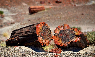
Petrified logs are created when a log gets buried in sediment, preventing rot, and then becomes

infiltrated by silica in the groundwater, replacing its organic material.  This stuff eventually

crystallizes and "petrifies" the whole log.  Over time, as erosion peels the ground out from under

the log, it cracks into short drum-shaped pieces that for all the world look like they are ready for

splitting.

We wandered through the

endless display of petrified logs

and even found a pile of geodes

out back.  This pile stood almost

10' tall and maybe 30' around at

the base.  What a treasure trove!

This is also dinosaur country,

and the local gift shops have all

kinds of fun making crazy

displays for tourists.  Mark found

a few out by the geodes.

Petrified Forest National Park is an easy park to miss

inadvertently because it sits on a road that cuts between an

Arizona highway and an interstate.  We had made that mistake

years ago.  We had driven along at 55 mph waiting to see a

Forest, and we skipped the pullouts because there was no

evidence there was any Forest there.  After an hour we emerged

at the other end of the park having seen nothing but wide plains

and a few scattered logs in the distance.  That goof-up has been

a standing joke between us ever since.

The only way to see this national park is to get out

and do some hikes.  The hilly field behind the

visitors center is strewn with huge logs, many

resting in a row and fitting together to make an

entire tree trunk.  These things are massively heavy

and are 8 times harder to cut than granite.  From a

distance the crystalized bark, knots and tree rings

look lifelike, but up close the agate colors merge

and swirl in non-treelike patterns.

We hiked on the Long Logs trail which features one tree

trunk after another, each one segmented into shorter

logs that lie end-to-end.  Looking around the sweeping,

empty, grassy plains it is hard to imagine that 260 million

years ago this area was a logjam in an ancient riverbed,

back when all the continents were joined and Arizona's

latitude was somewhere around modern day Panama.

13 species of large but extinct pines forested the area.

Out at the Agate House we

found an ancient Indian

pueblo made of petrified

wood pieces.  Archaeologists

believe it was constructed

between 1050 and 1300 AD.

Those guys built very small

buildings.

The trail took us past tall,

horizontally striped "sand

piles" that are now solid

stone.  It looked like a gravel

yard that had been carefully

layered in different types of gravel.  The heights of the

dark stripes matched from one pile to the next.  There is

an otherworldly quality to this landscape.

As we walked back to the

truck Mark spotted a collared

lizard sitting on a hunk of

petrified wood.  His little pink

mouth seemed to be grinning,

and his long skinny tail trailed

almost twice his body length

behind him.

This is cattle ranching country

too, and before we could get

to the petrified log that spans a chasm -- the Agate Bridge -- we had to

get past a group of cows standing in the middle of the road.  These

guys didn't move an inch as we drove past.  Only their heads turned to

watch us as our enormous truck and trailer nearly brushed them when

we drove by.

The Puerco Pueblo hike took us to an ancient Indian settlement built

around 1250 AD.  It was home to some 1,200 people.  6'x8' was a typical

room size, and unlike the mammoth Mayan and Zapotec buildings we'd

seen a few thousand miles to the south, these ruined walls have been

reconstructed to

just a foot in height.

Far more intriguing

for us were the

petroglyphs that the

ancients had

pecked into the nearby rocks.  One showed what

looked to me like a stork carrying a baby.  I'm sure

the archaeologists would disagree about that, but

these images are often a bit like ink blots -- what

you see in them is up to you.

The park road crosses I-40 and deposits visitors in

the middle of the Painted Desert.  But first you get a glimpse of the

Santa Fe railroad and some relics of the old Route 66.  While we

were wandering the hiking trails closest to I-40 we kept hearing

the horns and rumbles of endlessly long trains rolling past.  I

climbed up on a bridge overlooking the tracks and caught a train

as it approached.  Running to the other side I watched it

disappear around the bend.  These tracks date back to 1882

when the Atlantic and Pacific Railroad went through.  Early visitors

to the park arrived by train and took guided tours hosted by the

Fred Harvey company.

Mark was fascinated by an ancient rusting hulk of a car

that had been abandoned long ago on the side of the

old Route 66.  Stretching 2,200 miles from Chicago to

Los Angeles, that historic road passed right through

this area, bringing tourists to the park in their own

private cars instead of by train.  Now this part of Route

66 is overgrown by prairie grasses.

Our final miles along the park road

took us past some incredible vistas

overlooking the Painted Desert.  This is

a colorful area of more gravel-pit

looking solid stone "sand piles," and

we had taken so long

getting through the park

that we arrived while the

late afternoon sun was

lighting the vivid

landscape to its most

brilliant hues.  Gazing out

at this exotic land, the

sun beating down on us

and our sinuses rapidly

shriveling up in the dry air, it was hard to imagine what the ancients or the early

settlers must have thought or how they even survived.  So harsh and yet so

beautiful.

By now our spirits were fully restored.  As we studied our maps we decided to

head north via the tiny squiggle labeled "Indian Route 12" and head towards

Canyon de Chelly National Park.  This road was marked as a scenic route

but despite being Arizona residents before our traveling lifestyle we had never

heard of it before.


Loreto Area: La Ramada Cove, Isla Coronado & Puerto Escondido – Gifts From and To the Sea

Sea of Cortez islands, mountains and peninsulas blend into each other.

Bahía Concepción: the islands, mountains and peninsulas blend together.

Noting the accuracies and inaccuracies of modern electronic navigation in the Sea of Cortez.

Leaving Bahía Concepción the orange islands are inaccurately

charted.  The purple radar image shows the correct locations. 

The red triangles identify accurate GPS locations of the islands. 

Our boat is the size of a city block.

Dangerous pinnacle rocks near Puerto Escondido.

Dangerous pinnacle rocks.

Pinnacle rock near Puerto Escondido.

Pinnacles dot the Sea of Cortez landscape.

La Ramada Cove, Baja California Sur, Mexico.

La Ramada Cove.

Strolling the beach at La Ramada Cove, Baja California Sur, Mexico.

Strolling the beach at La Ramada.

Clear water at La Ramada Cove, Baja California Sur, Mexico.

Perfectly clear water.

Groovy anchored at La Ramada Cove, Baja California Sur, Mexico. Looking down at San Juanico, Baja California Sur, Mexico

Caleta San Juanico.

Looking down at San Juanico, Baja California Sur, Mexico

San Juanico

Groovy catches the wind and heads south.

Groovy catches the wind and

heads south.

Dolphin swims underwater next to Groovy.

Dolphin swims underwater next to Groovy.

Brightly colored cliffs near Loreto, Baja California Sur, Mexico

Brightly colored cliffs near Loreto.

Happy sailing on Groovy. Hidden beach at Isla Coronado, Baja California Sur, Mexico

Hidden beach at Isla Coronado.

Vivid colors at our private beach on Isla Coronado, Sea of Cortez.

Vivid colors at our private beach.

Footprints in the sand at Isla Coronado, Sea of Cortez, Mexico.

It's just us and the

herons.

Hidden beach at Isla Coronado, Baja California Sur, Mexico

Isla Coronado.

Hidden beach at Isla Coronado, Baja California Sur, Mexico

Private islando oasis at Isla Coronado.

Beachside villas outside Loreto, BCS, Sea of Cortez, Mexico.

Waterfront civilization just outside of Loreto.

Walking towards Loreto's town square, BCS, Sea of Cortez, Mexico

Walking towards Loreto's town square.

Inside the atrium at the Hotel Posada de las Flores, Loreto, BCS, Sea of Cortez, Mexico

Inside the Hotel Posada

Inside he atrium at Hotel Posada de las Flores, Loreto, BCS, Sea of Cortez, Mexico.

Hotel Posada de las Flores.

Loreto Mission of Our Lady, Loreto Cathedral (Misión de Nuestra Señora de Loreto Concho, Baja California Sur, Sea of Cortez, Mexico

Loreto's "Misión de Nuestra Señora."

Inside Loreto Mission of Our Lady, Loreto Cathedra (Misión de Nuestra Señora de Loreto Concho, Baja California Sur, Sea of Cortez, Mexico

Inside the cathedral.

Capturing the Loreto Mission Church (cathedral) on an iPad, Baja California Sur, Mexico

Capturing the antique cathedral on

an iPad.

Marina Puerto Escondido, BCS, Sea of Cortez, Mexico

Puerto Escondido's marina docks.

Puerto Escondido fuel dock, Baja California Sur, Sea of Cortez, Mexico

Groovy waits at the fuel dock.

Los Candeleros, outside Puerto Escondido, BCS, Sea of Cortez, Mexico

A boat is lost on a pinnacle rock.

Boat on the rocks at Los Candeleros, outside Puerto Escondido, BCS, Sea of Cortez, Mexico Shipwreck at Los Candeleros, outside Puerto Escondido, BCS, Sea of Cortez, Mexico

Mark catches a Skip Jack Tuna.

Closeup of the Skip Jack Tuna.

La Ramada, Isla Coronado, Puerto Escondido, & Loreto

Late October, 2011 - It was hard to leave Bahía Concepción, but the time finally came and we headed out of the bay to

continue our trek south.  Looking back over our shoulders we were reminded once again what a miracle GPS and electronic

marine navigation systems are for sailors today.  In his Log of the Sea of Cortez, John Steinbeck talks about how hard it was to

navigate these waters in 1940 when the only tools the captain had were some sketchy charts and a coastal pilot book.  The

islands are often indistinguishable from the mainland mountains and peninsulas, and the rugged coast often becomes a

bewildering mirage.

A glance at our chartplotter shows just how confusing this

landscape can be even today, but for different reasons.

Unlike navigating in the US where electronic charts are

accurate down to individual slips within marinas, the

survey data used in Mexico's modern electronic charts

was collected not long after Steinbeck's voyage.  Although

it gives a general idea of the layout and depths, it is often

inaccurate by a half mile, mile, or more.  Islands that don't

exist feature prominently on the charts, and islands that

are a true threat in the water are nowhere to be found on

the charts.  Fortunately the boat's radar tells the story as it

really is, and the electronic chartplotter overlays the radar

image onto the chart.  You get used to sailing through

charted obstacles that aren't actually there.

The thing about the Sea of Cortez is that there are lots of pinnacle rocks

that stick up out of nowhere.  Most are fifty feet or more in height, making

them easy to spot with radar and with bare eyes.  But you still have to stay

on your toes, as many of them don't appear on the charts and can loom

up unexpectedly.

Fortunately, the guidebook Sea of Cortez by Bansmer/

Breeding lists the GPS coordinates of every danger and

destination in the Sea, so for a boat equipped with a GPS

chartplotter, navigation is actually an easy paint-by-

numbers affair.

The prevailing winds in the Sea of Cortez generally blow either from the north

or the south, and in autumn you get a few days of one direction alternating

with a few days from the other as the summer's predominant south winds give

way to winter's predominant north winds.  We caught a ride with a big north

wind that swept us south to our next destination, La Ramada Cove.

This picturesque

spot is protected

only on its southern

side, but we got

lucky and the winds

shifted to the south

for the next few

days.

So we were able to enjoy the isolation, peace and quiet of this idyllic

anchorage while staying just out of reach of the south wind that howled

outside the cove.

The water was beautifully clear and warm,

and sitting on the edge of the cockpit we

could see fish of all kinds swimming under

our boat, flashing in the sun as they zipped

this way and that.

One night we came on deck to see the most unusual bioluminescence.  Brilliant little sparkling "eyes"

seemed to be looking up at us from the black depths all around the boat.  One at a time they would

wink a few times and then suddenly burst and fade away into the black depths.  As each light

exploded and dispersed it seemed to take on the shape of a jellyfish, but our flashlights revealed

nothing but ordinary fish around the boat.  After a while the glittering stars disappeared.  We still don't

know what they were.

One afternoon we hiked the

short distance from our beach

at La Ramada Cove to the

scenic cove of San Juanico on

the other side of a small hill.

We had spent several

languorous days at Caleta San

Juanico last spring, but now the

anchorage was deserted

because its mouth opens to the

south, which would have made

it very uncomfortable in the

current south wind.

However, the osprey were still

there, perfectly content with nature's unpredictability,

not worried in the least whether the wind was from

the north or south.

We caught the next north blow to carry us a little

further south to Isla Coronado outside of Loreto.

A pod of dolphins spotted us underway and came

leaping over to greet us.  The water was so clear we

could see them perfectly as they swam under the

water alongside the boat.

Our route followed the contour of the mountains that make up Baja's

shoreline, and in places they were dramatically striated in shades of

red, black, brown and grey.

This is the magic of the Sea of Cortez.  It is a rugged, remote, barren,

harsh land, but if you look beyond the surface it reveals a dramatic

beauty and is teeming with life.

Last spring Isla Coronado had been the scene of some of the

worst conditions we had experienced in seven months of cruising

Mexico when an unexpected post-season Norther blasted the little

north-facing anchorage.  Fortunately, when we arrived this time

the bay was tranquil and inviting.  We shared our island oasis with

just one other boat, Valkyrie, a small sloop captained by a friendly

singlehander.

There is a

private beach

away from the

anchorage,

and we took the

dinghy over to

explore.

Lush green

vegetation stood

out in sharp relief

against the

burgundy carpeted

rocks in the

distance.

We felt like we were standing on our own

private island, a world away from reality.

Our footprints joined those of

the herons that had been

walking on the sand earlier.

But there were hints of

civilization.  After several

days without contact, we

were now able to get internet

access via the cell phone

tower at Loreto just a few

miles away from our island.

Soon we were lured across

the water to visit the town in

person, and we anchored outside

Loreto's tiny harbor.

It was a great feeling to

return to a town we had

come to know and love

last spring.  We saw it

now with fresh eyes.

The town was celebrating

its 314th anniversary

when we arrived, and a

portion of the town

square was decked out

for the weekend's festivities.

We returned on the big night,

and the place was hopping

with music, fun, food, and stage events.  If that

is how Loreto celebrates turning 314, imagine

what will happen when they hit a round

number.

The ornate Hotel Posada de las Flores and the Mission

of Our Lady Church dominate the town square.

In a wonderful juxtaposition of the modern and the

antique, I watched a man lining up a photo of the

historic cathedral on his iPad.  After he got his shot, a

group of us all stood around and admired his wonderfully backlit 8x10

photo.  It was beautifully accented by the iPad's white frame and

made me realize what a long way we've come since the days of

Polaroid.

A few days of big north winds and accompanying steep waves sent

us into hiding nearby at Puerto Ballandra, one of the few truly

protected anchorages in the Sea.  Last spring it had been nicknamed

"Bee Landra" because of the abundance of fresh water seeking bees

that harassed all the boats.  We decided a few bees in a peaceful

anchorage would be better than rolling around in big seas and winds somewhere else.  As

it turned out, the bees were few and manageable, due, in part, to the really good fly

swatters we brought down with us this season!  With the Sea of Cortez bees we have

found that the best defense is an aggressive offense.  None of that pansy "leave the bee

alone and it won't bother you" stuff.  We go all out in our attacks, swatting the air, the boat

and each other to kill the scout bees.  They are slow moving and must be a bit delicate, as

they are easy (and very satisfying) to kill with a swatter. (I tried asking them nicely to

leave, but they refused).

While in Puerto Ballandra one

afternoon we were idly watching

a boat sailing towards the entrance when we noticed that by dusk it

still hadn't made it into the anchorage.  Mark hopped in a friend's

dinghy and they motored out to see if the boat needed help.  It turned

out that along with a broken engine and a sail that was stuck partially

raised, the fellow sailing the boat could not find the entrance to the bay

and had been drifting back and forth looking for it all afternoon.  He

was confused by the mirage of rocky peaks, and didn't have any

electronic navigation gear on board.  Darkness fell, and Mark and his

buddy guided the boat into the anchorage, nudging it forward with the

dink, and helped him find a place to drop the hook.

When the north wind diminished to a manageable scale we

continued moving south, making a quick fuel stop at Puerto

Escondido, the only place with fuel for a hundred miles or so

in either direction.

As we sailed towards Puerto Escondido there was a lot of

commotion on the radio about a boat that had gone up on the

rocks nearby.  There were no injuries, but the singlehanding

captain was rapidly unloading all his belongings onto the

rocks and examining a six inch wide hole in the bottom of the

boat to see if there was any way to salvage it.  We listened as

a group assembled to lend assistance and bring out sheets of

plywood, bilge pumps and moral support.

The next morning as we left Puerto Escondido we could

see something glinting in the sun on the horizon ahead of

us.  Soon it morphed into a sailboat on its side in front of

a towering pinnacle rock, and we realized this was the

boat we had heard about the day before.  This pinnacle

rock was one of several in the area called "Los

Candeleros" ("The Candlesticks").  We later sadly

discovered the boat was Valkyrie, the one we had

anchored with at Isla Coronado a few days earlier.

Tragically, the captain had driven straight into the

pinnacle rock and nailed it head on.  Ouch.  Thank

goodness the only loss was material.

Taking a deep breath and forging ahead, we made our way south

towards Agua Verde.  With no wind and nothing to do on board as

we motored along (just one pinnacle rock for 40 miles), Mark threw

out a fishing line.  Last year all the cruisers complained of bad fishing

up and down the entire west coast of Mexico.  So we were stunned

when within half an hour Mark had landed a fish.  Wow!  Yikes!!  What to do?  We were totally unprepared for a fish actually

biting the lure.  I ran around excitedly, trying to be helpful, "Are you going to stun it by pouring alcohol in its mouth like our

friends suggested?  What kind - rubbing alcohol?  Where do we keep that stuff?  Are you going to slit the gills to kills it?  Do you

need a knife?  A cutting board?  Gosh, you gotta do something with that flopping fish, and quick!"  I must have run up and down

the companionway stairs six times.  At least I didn't cry this time.

Mark was much more level headed.  He calmly threw some ice in a bucket and put the bucket and

the fish in the dinghy off the back while we continued on to Agua Verde.

One of the weird things about

fishing is figuring out what you

caught.  Fish don't come with

labels and a lot of species don't

taste good and need to be

thrown back.  Mark looked up his

catch in a book, and it was a Skip

Jack Tuna, rated as "good

eating."  Sure enough, once we

were anchored he filleted it like a

pro and barbecued it.  We

enjoyed it for three absolutely

yummy meals over the next few

days as we made our way south

towards the beauitful island anchorages near La Paz.

Read more about our adventures in the anchorages near Loreto during our previous visit in May, 2011, here and here.

Find La Ramada Cove, San Juanico, Isla Coronado, Loreto, Puerto Escondido and Agua Verde on Mexico Maps.

**While in Acapulco we read an article in their yacht club magazine about the salvage and recovery of the yacht Valkyrie!


Red Canyon Utah is an Overlooked Treasure

RV blog post - Red Canyon, Utah, is easy to miss, but  the hiking trails, bike path, hoodoos and spectacular views worthy of an extended stay.

Red Canyon Tunnel

Red Canyon, Utah, bike path.

Bike path through Red Canyon

Red Canyon, Utah, bike path.

The bike path is almost 9 miles long.

Red Canyon, Utah, bike path. Camped outside Red Canyon, Utah. Afternoon rainbow outside Bryce Canyon, Utah

Afternoon rainbow.

Morning visitors outside Bryce Canyon, Utah

Early morning visitor.

Red Canyon visitors center, Utah.

View from the Red Canyon visitors center.

Red Canyon hoodoos.

Hoodoos.

Red Canyon peekaboo arch.

A peephole on Pink Ledges Trail.

Views on Pink Ledges Trail, Red Canyon, Utah.

Burnt orange and forest green

backed by blue sky are the

colors of Red Canyon

Views on Pink Ledges Trail, Red Canyon, Utah.

Pink Ledges Trail.

Hoodoos on Pink Ledges Trail, Red Canyon, Utah. A storm approaches on Pink Ledges Trail, Red Canyon, Utah.

Storms roll in every afternoon.

Hoodoos on Pink Ledges Trail, Red Canyon, Utah remind us of Easter Island heads.

Utah's red rock answer to

Easter Island.

Bryce Canyon Rim Run - 5 miles of racing fun.

Bryce Canyon

Rim Run.

Wildflower at Red Canyon, Utah. Hikers headed to Bryce Canyon.

Ken and Marcia Powers,

exceptional long distance hikers.

The scenic road through Red Canyon, Utah.

The road through Red Canyon.

Bird's Eye View Trail in Red Canyon, Utah. Bird's Eye View Trail in Red Canyon, Utah.

Bird's Eye View Trail.

Hoodoos on Bird's Eye View Trail in Red Canyon, Utah. Tunnel Trail in Red Canyon, Utah.

Tunnel Trail.

Horses on the Red Canyon bike path, Utah. Mormon hand-cart in Panguitch, Utah.

Mormon hand-cart in Panguitch.

Quilt Walk Statue in Panguitch, Utah.

Mark helps commemorate the Quilt Walk.

Downtown Panguitch, Utah.

Downtown Panguitch.

Historic brick pioneer homestead, Panguitch, UT

Historic brick pioneer

homestead.

Cowboy Cafe Steakhouse -- a historic jail ? -- in Panguitch, UT

Perhaps the site of the

infamous jail.

Ebenezer Bryce's cabin in Tropic, Utah.

Home of Ebenezer Bryce, of "Bryce's Canyon."

Storms approach Arches Trail in Red Canyon, Utah.

Storms approach Arches Trail.

The first big arch along Arches Trail in Red Canyon, UT

Our one and only arch sighting.

Red Canyon, Utah

Late August, 2011 - We were on a roll uncovering the many gems that make up

America's finest crown jewels in Southern Utah.  Leaving Cedar Breaks, we pointed

the truck down the hill towards Red Canyon.  Most people on this road are headed to

the more famous Bryce Canyon National Park which lies just a little further on, and few

are aware that their path will cut right through the fabulous rock formations of Red

Canyon on their way there.  It's amusing to watch the steady stream of international

tourists flying through this five mile stretch of road, because as soon as they get into

Red Canyon the car windows fly open and heads pop out as the driver swerves into

the nearest pullout.  It is that beautiful.

We did that too, years ago.  And just like

everyone else, each time we have been back to

Bryce we've breezed through Red Canyon

without sticking around long enough to see it up

close.  All we had ever seen was the fantastic

paved bike path that weaves through the canyon

walls for almost 9 miles of spectacular riding.

Years ago we had ridden this

path when the bright blue

lupines were in bloom, but

this year we came later in the

season and the color

trimming the red rock views

was bright yellow.

There is a delightful little

campground in Red

Canyon where we had

camped in a tent long

ago.  It was there, in the

rain (which comes every

afternoon in July and

August), that we decided to get a trailer.  While we were shivering and running around

looking for indoor activities during the rain, we saw people kicking back in their RVs as

snug as little bugs in rugs.  Within two weeks of returning to Phoenix we had purchased

our first pop-up tent trailer and pickup truck.

This time we found a spot to

camp nearby and watched

the afternoon monsoon

clouds build and swirl  The

sky would go from bright blue

in the morning to almost

black in the afternoon, and then

huge raindrops would fall.

Sometimes we were blessed with

a rainbow.

One morning we woke to the

sound of cows mooing, and a small herd walked into a

corral nearby and hung out for a while, as if they were

waiting for the rancher and his truck to show up and take

them to market.

Red Canyon boasts many hiking trails, but some of

the best are short ones right outside the visitor

center.

Pink Ledges Trail took us on a winding, narrow path

partway up the canyon walls.  It led us back into a

vivid red backdrop of craggy rocks decorated with

rich green trees and then wound back out again

towards some hoodoos.

As usual, a storm was gathering in the

distance, and the sky got darker and

darker.  The hoodoos -- humanlike,

almost sculpted rock formations --

resembled the giant heads of Easter

Island.  But these were not crafted by

human hands and they glowed a rich

burnt orange.

We had found it extremely challenging to keep up any

kind of fitness regimen on the boat last winter, and as

soon as we got back to Phoenix, Mark had started

running everyday.  I was a little slower to get going,

but by the time we got to Red Canyon I had put my

running shoes on a few times.

Mark found out there was a 5 mile race at Bryce

Canyon, and before I had a chance to say, "How far?,"

there I was at the start line.  Luckily, the beginning of

the course wound along the edge of Bryce Canyon,

keeping my mind happily occupied with the views.  But when the route turned

away from the rim into the woods and continued uphill for over a mile all I could

think was, "Why did we start this exercise program at an altitude of 8,400 feet?"

Thrilled to have survived the race, we were

inspired to keep training.  One day I ran past

a couple walking down the road with walking

sticks and serious looking backpacks.  There

was nothing up the road for at least 30 miles,

so I had to stop running and find out where they had come from.  It

turns out they had walked 60 miles in the past three days to launch a

two month walking adventure.  They planned to hike through Bryce

Canyon into Utah's canyon country towards Page, Arizona where they

would arrive around Halloween.  Taking a breather at our trailer, they

told us their names were Ken and Marcia Powers and we discovered

they are celebrated hikers who have hiked not only the entire

Appalachian Trail and Pacific

Crest Trail but were the first

people to hike the entire cross-

country American Discovery Trail in one continuous hike

(it took 8 months).  They have done all this since they

retired 11 years ago.  "We didn't want to just sit at home,"

Marcia said.  They have logged thousands of miles of

other long distance hikes, and they chronicle their

adventures at http://www.GottaWalk.com.

We continued ticking off the short hikes around Red

Canyon, very self-conscious now that they were all just a

measly mile or so.  But they were spectacular.  The Bird's

Eye View hike goes up around the backside of the canyon

and the Tunnel Trail Hike follows a series of switchbacks

up a steep hill until it deposits you at a fantastic viewpoint

overlooking one of the tunnels spanning the main road.

Taking a break from the red rocks, we

ventured into the nearby town of

Panguitch.  A small city park

celebrates the town's mormon pioneer

history, and a hand-cart in the park

reminded us that whole groups of

people of all ages, some pulling hand-

carts, walked across this country

years ago to settle Utah.

Those pioneers were tough folk.  In 1864 the new mormon settlers in Panguitch

were starving, and seven men set out to cross the snow-covered mountains to

get supplies from Parowan some 40 miles away over a steep pass.  Unable to

make progress in the deep snow, they threw out a quilt and gathered on it to

pray.  Noticing the quilt supported their weight in the soft snow, they began

laying quilts out ahead and walking across them.  Amazingly, they walked all the

way to Parowan and back this way, lugging heavy loads of flour with them on

the return trip.  Mark decided to help out the commemorative Quit Walk statue

with his quilt.

The downtown

area of Panguitch

is listed on the National

Register of Historic Places, and

I had a walking tour map that

pointed out certain historic

homes and buildings.  The jail

intrigued me, but the location

on the map didn't correlate with

any buildings.

I began asking around, and

ended up on a wild goose chase as one shopkeeper sent me

to the next and I finally ended up with a group of little old white

haired ladies "who know all the history of this town."  My jail

query started quite a discussion among them, but not one was

sure where this jail was or might have been.  "It's down by your

house," one woman said.  "A jail by my house?  No, it was at

the other end of town…"  We were all laughing by the time I

left, but apparently this historic jail in this historic town had

slipped from historic memory.  Making one last stop at

Cowboy's Steakhouse Cafe on my way

out of town, the bartender said

thoughtfully, "Well, this building used to

be a jail.  I think what you're looking for

is right here."

An easier landmark to find was in the

town of Tropic in the opposite direction

past Bryce Canyon.  Back in the

mid-1870's, Ebenezer Bryce built a road through the woods leading to

a pink cliff canyon to make timber more accessible for the settlers of

the area.  The amphitheater of red rock at the end of his road became

known as "Bryce's Canyon," even though he moved to Arizona just a

few years later.  His wee home is on display in Tropic.  Poking our

heads inside the tiny door, I couldn't imagine what winters were like for

a real family of full-sized people living in such a dollhouse.

Ready for one last blast of red rocks, we checked out Arches Trail at

the edge of Red Canyon.  This trail boasts 15 arches, although a

couple completing the hike as we arrived said they had found only

five.  We charged up the path, quickly deciding that this was by far the

best hike of them all.  The path twists and turns as it climbs, and each

view is more enchanting than the last.  We spotted an arch and

rushed up to it just as a huge thunder-boomer rumbled and lightning

flashed in the distance.

In no time at all the sky went black.  We saw a cave in the distance

and hatched a plan to go hide in the cave until the rain ended.

What a terrific adventure that would be!  But we couldn't find a

path to the cave, so we ran back to the truck instead.

Unfortunately, the rain wasn't the kind that would blow over any

time soon, and we were leaving Red Canyon next day, so when

we drove away from Arches Trail we realized we were leaving

most of it for a future visit to Red Canyon.  But at least we now

know it is a hike that is well worth doing!

We hustled south along I-15 making stops for the Iron County Fair in Parowan, Utah and the Interbike bicycle trade show in Las

Vegas, Nevada, and we finally landed in Williams, Arizona on famous Route 66.