

Unusual rock formations line the road.

A deer says "hello" at Mesa Verde.

The Tower House, Mesa Verde Nat'l Park

Stone masonry from sandstone bricks.

They were as good at round walls as straight ones.

Communities are tucked under overhanging cliff walls.

Looking closer in.

Above the cliffs is flat land -- some has
been burned by wildfires.

A closer look at the buildings below.

Split-level living with some buildings on a higher ledge
and others on a lower one.

Cliff Palace.

A closer look at Cliff Palace.

A tour group walks through the Cliff Palace ruins.

An above-ground structure at Sun Temple.


The Far View Sites.

Don't Touch!!!

No climbing -- unless you're a
ranger.


Landscapes as we leave Colorado and enter Utah.

The real deal.

Winter wheat at twilight.

An old truck out back behind Jack's shop.

What else to do while waiting for work
on the trailer - take photos!

The round plastic handle was becoming square.


The design.

Jack and the finished product.

How it works and what it does.

Ta da!!

The Bicentennial Highway, Route 95 in Utah.

Typical sights along the "Bicentennial Highway"

Scenic Route 95.

"Oh oh oh oh -- it's perfect!!"


View out the window.

No one for five miles in any direction.

Why we love RVing in Utah.
Mesa Verde National Park & Eastern Utah.
Early June, 2012 - The mysterious cliff dwellings of Canyon de Chelly
National Park in Arizona had inspired us, so now we pointed our buggy
in the direction of Colorado's Mesa Verde National Park where another
massive cluster of cave homes lines the canyon walls.
We passed many
dramatic rock
formations on our
way, and we were
greeted by a deer
when we first
entered the park.
Mesa Verde is a vast park that requires a lot of driving on hilly twisty roads to
see all the sights. We were surprised by the huge number of tourists crammed
into the Visitors Center, especially compared to the quiet and laid back nature
of Canyon de Chelly. This is a park where you could easily stay a week or
more. The place is packed with different cliff dwelling structures as well as
above-ground ancient Indian ruins.
We tried to get our bearings quickly and headed out to the
Square Tower house. After driving some 10 miles or so
through the park winding along hill crests on curvy roads, it
was quite a surprise to walk down a short trail, turn a
corner, and find ourselves staring down at a beautiful intact
ruin.
The little community stood tightly pressed against a back-sweeping cliff
wall. The tower building was four stories tall with a large window on each
floor. But it all looked like a miniature doll house compound down there, far below our feet.
The buildings are made of sandstone bricks, each one about the size of a
loaf of bread, and they are mortared with a mixture of dirt and water. The
Ancestral Puebloans - or Anasazi - built these structures around 1100 to
1300 AD, but sadly left no written documentation behind.
At the Mayan ruins of southern Mexico we had been shocked to discover
that entire dynastic histories are known in detail today, right down to kings'
birthdays, city-state conquests and squabbles for power. However, at
these Indian ruins in Colorado we learned that very little is known with
certainty about the people who built and lived in them.
As we wound along the tops of the canyon walls, we were amazed to look
out across the narrow ditch and see all the tiny dwellings tucked into the
opposite canyon wall. At first all we could see was the faces of the cliffs,
but as our eyes adjusted to spotting the cave homes across the way,
suddenly they become obvious in every nook and cranny.
The park offers inexpensive tours of most of the ruins, but we contented ourselves
with getting an overview of it all from the top rather than climbing down in.
When we finally reached the Sun Temple overlook, the best place
to view the magnificent Cliff Palace ruins, we were amazed by the
complexity and density of the buildings. It was a complete town
nestled into a cave midway up a rock wall.
A tour group was passing through the ruin, and the tiny, brightly
colored people walking among the buildings gave us an interesting
perspective on this place. This canyon and its massive rock
formations is immense and timeless. But the people who built their
homes here stayed for just a few generations and filed through this
ageless place rather quickly. Fortunately for us today, they left a
most unusual signature behind: uneven, jam-packed housing.
We learned that the
first people to settle
this region were the
Basketmakers who wove very fine
basketry and built pole-and-adobe
houses above ground starting
around 750 AD. By 1,000 AD, just
before the Norman conquests of
England, they began building their
homes using stone masonry.
Interestingly, archaeologists say
their basketmaking skills showed
a marked decline once they
began to specialize in masonry.
It's intriguing to me that one skill rose while another
fell. And isn't it still so true today. We are all expert
at moving over ground at 60 mph but most of us
would balk at killing, plucking and carving up a
chicken for dinner, something our great-
grandparentss happily did years ago. We have all
become so adroit with electronic and keyboard
technology, but gosh darn if we aren't all forgetting
how to spell.
We wandered among the above-ground dwellings
and hiked around the Sun Temple and Megalithic
house. Like the Mayans at Bonampak who had
created an elaborate series of murals inside one
of their ruins but abandoned the building before
it was finished, here at Mesa Verde the Anasazi
had also abandoned their property before it was
totally completed. It is baffling to ponder how a
society can reach such heights of sophistication
and then vanish.
Unlike the Mayan ruins, however, where today's
visitors can scamper all over every building at
will, we saw signs posted everywhere telling us
not to touch or climb on anything.
Rangers, of course, are excepted…
Somewhere in our meanderings through Mesa
Verde we realized that we had reached total saturation with seeing the ancient
dwellings of antique cultures. We had seen some of the best of the best in the
last six months, and we were ready for a change of pace.
We left the Indians and Colorado behind and
crossed over into Utah, stopping at a gas station
to fill the truck. From somewhere in the distance
we heard the clank-clank-clank of spurs coming
towards us, and suddenly we found ourselves
face to face with a cowboy. Not a cowboy-hatted
urbanite donning the clothes and stance of his
country idol, but the real deal: a young,
hardworking cowboy who had just finished a dirty
week of cattle work.
When he started gassing up his truck, Mark struck up a conversation. It turned out he'd been
ranching all his life and now commuted every other week between Ogden at the north end of Utah
and Blanding a few hundred miles south at the other end of the state, to work on a ranch. He beamed
as he told us he had just found a house in the Blanding area so he could move his family down this
way. "Heidi is real happy," he drawled slowly, his bright blue eyes twinkling.
We asked him if our planned drive along Route 95 would be okay with our big truck and trailer (we
had read something about 8% grades). "Oh yeah," he said very slowly. "It's a real pretty drive.
That's how I go back and forth to Ogden." What a life: outdoors all day in some of the country's most
dramatic landscapes, and commuting to work on a National Scenic Highway.
Reassured that we would't be facing any gnarly
driving, we left the gas station and promptly
bottomed out the back end of the trailer on the
lip of the driveway. Our brand new bike rack that
we both just love scraped the pavement loudly
and the truck ground almost to a complete stop.
Mark made a face at me, and we leaped out of
the truck to check the damage. "We gotta fix
that!" He said nervously. But we were both
relieved that there was no damage worse than a few scratches. Our fantastic
new bike rack has been such a great addition to our travels this season, but it
hangs way out from the back of the trailer. This was the fourth time we'd
scraped it hard on the ground, and the once-round plastic knob on the back
was becoming rather square.
We drove over to the Visitors Center and found an old fellow deep in conversation with
the lady behind the desk. We asked if there was a good welder in town who could
fabricate something for a trailer hitch. They told us that JM Welding just on the edge of
town by the airport would do a great job for us.
Still uneasy about the Scenic Route 95 ahead of us that was known to
be so beautiful but scurried diagonally across the Utah map as if it
were a cat chasing a butterfly, I asked the pair if that route was okay
for a big truck and trailer. "Route 95?" the man said, "Why, I built that
road." Turns out that the construction of this road, known as the
Bicentennial Highway, had spanned from the 1930's to 1976 when it
finally got paved, and this man, Ferd Johnson, had been part of the
team that built it.
"We all lived out in the canyons for two and a half years while we built
that road." He said, telling us how rugged and wild and beautiful the
land was. "There are three bridges crossing the Colorado river, and
those were tough…" he trailed off. The lady behind the desk piped
up. "I did the drive once with him," she said nodding in his direction,
"and he talked the whole way. He had a story about
every mile of that road."
We left really excited to see this
scenic highway for ourselves. But our
first stop was at JM Welding. Jack,
the owner, understood exactly what
we wanted and said he could order
something like that and have it for us
tomorrow. "Or I can build one for you
right now that would be better quality
for about the same cost." Go for it!!
He grabbed a piece of chalk from his
pocket and drew an outline of a z-shaped
hitch extension on the shop's concrete
floor. Within moments his son had cut the
pieces and welded them. Jack powdered
coated it and cooked it for an hour while we chatted with Jed,
one of Jack's long-time customers who had just showed up.
"I'm really looking forward to driving that famous scenic Route
95 tomorrow," I said, making idle conversation. Jed looked at
me blankly. "Scenic road? There's a scenic road out
here?" I did a double-take. "You know, that Scenic Route
95. You take a right just a mile south of here…" He
scratched his head. "Oh, right…of course…oh yeah. I
drive that road all the time. It's pretty."
As we drove this magnificent road over the next two days,
our jaws dropping repeatedly at the stunning beauty around
us, we had to laugh. Utahans live in some of the most
spectacular scenery America has to offer, but I guess after
a while it becomes an ordinary backdrop for their lives.
In no time Jack had finished our hitch extension
and Mark mounted it on our trailer. Suddenly all
our fears of grinding our new bike rack into the
dust while boondocking down rough dirt roads
vanished.
Next morning, after a peaceful
night parked out behind Jack's
shop where fields of winter wheat
waved softly in the twilight and
dawn, we struck out on scenic
Route 95.
From red rock cliffs to exotic
pink-and-white striped swirling
rock formations to dramatic
descents into vivid green valleys,
we drove with our heads turning
constantly.
I literally hung
my whole
upper body out
the window a
few times to
snap photos at
55 mph.
The road swerved here and
there, curving deliciously
between cliffs and canyons.
Suddenly I saw a dirt road
scooting off to a wide flat
plateau. "Oh oh oh!!!" I
cried, not quite getting any
words out. "It's perfect!"
Mark skidded to a stop,
squeaked out a u-turn and
drove back. What a
sweetie!
Down the dirt road we went, bumping along to the most fabulous
and dramatic boondocking spot. There wasn't anyone around
us for at least five miles in any direction, and we had the
canyon, the cliffs and the sky to ourselves. That is the magic of
RVing in Utah. 50% of the state is public land, and you can
camp anywhere you dare to take your rig. It was so beautiful we
stayed for a few more days before exploring Natural Bridges
More blog posts from our RV trips to Colorado:
- Escape to Paradise – Rocky Mountain Magic!
- Sheep May Safely Graze (in the Mountains with Dogs!)
- Hartman Rocks – A Different View of Colorado near Gunnison
- Creede, CO – Mining History & Championships + 4th of July!
- Buena Vista Colorado – What a Place for an RV Breakdown!
- Rocky Mountain National Park & Trail Ridge Road: RV? Dog??
- Lake Granby Colorado RV Trip – A Summer Beach Vacation!
- Remote RV Camping: Antero Reservoir & Blue River Colorado
- Burro Days! Burro Races, Llamas & Outhouses in Fairplay CO
- Crested Butte – Wildflower Capital of Colorado!
- Silver Thread Scenic Byway in Colorado – Fire in the Sky!
- Telluride Gondola Ride in Colorado – FREE and Dog Friendly!
- Rocky Mountain High: Alpine Beauty in Colorado + Trout Lake!
- Where All News is Good News – At the Saguache Crescent in CO
- Lakes and Light in Wyoming and Colorado
- Colorado’s Stunning Scenic Drives…by Porsche!
- Cowboy Poetry Gatherings in Durango, Colorado, and Alpine, Texas!
- Black Canyon of the Gunnison National Park, CO – Steep and Deep!
- Romance at Maroon Bells Colorado!
- Colorado National Monument & Fruita CO – Red Rocks, Cycling & Wine!
- Mesa Verde National Park, CO – Life on the Edge with the Ancients
Our most recent posts:
- Buckskin Mountain State Park – Fun on the Colorado River!
- How to Install Starlink Gen 3 in an RV? Use the Speedmount!
- Escape to Paradise – Rocky Mountain Magic!
- Is Forest River a Good RV? Well Built? Here’s Our Experience
- Sunset Crater Nat’l Monument – Lava & Camels at Bonito CG!
More of our Latest Posts are in the MENU.
New to this site?
Visit RVers Start Here to find where we keep all the good stuff. Also check out our COOL NEW GEAR STORE!! *** CLICK HERE *** to see it!
Natural Bridges National Monument & Utah’s Bicentennial Highway

At the top of Natural Bridges National Monument, Utah.

Some folks were put off by the
trail's wooden ladders.

Looking down is a bit unnerving!


The trail hugs a sheer canyon wall.

Barefoot tracks...


Dramatic cliffs and rock
formations everywhere


Full sized trees at the base of the cliffs.

Massive leaning walls are painted in vivid stripes.

Sipapu Bridge

Ladders...

…and carved stairs.


Striped cliff walls.

Kachina Bridge

Mark is dwarfed by Kachina Bridge.


Owachomo Bridge - delicate and soaring.

Owachomo Bridge.

The base of Owachomo Bridge.

"Bears Ears"

The Cheesebox.

Jacob's Chair.

Scenic Bicentennial Highway


Bridge over the Colorado.

Colorado River.


Scenic Overlook on the
Bicentennial Highway.

Ghost town Hite City lies underwater here.


The gods were messing with finger paints.

Scenic Route 24, Utah.

Capitol Reef National Park, Utah.

Capitol Reef National Park, Utah.
Natural Bridges and Utah's Bicentennial Highway
Early June, 2012 - After leaving Mesa Verde National Park we were
totally enthralled by the scenery that surrounded us on Utah's
Bicentennial Highway. This area is rich with exotic rock formations, and
three special ones are clustered at Natural Bridges National Monument.
While getting our hitch extension fabricated in Blanding we had learned
that our welder, Jack, had grown up playing among the bridge
formations before the modern park rules became so strict. "It was in
our backyard and we could camp anywhere in those days. I grew up
climbing all over those bridges."
Now it is a formal tourist attraction,
set aside and protected by the
government, with signs telling you all
the things you shouldn't do.
However, rather than having to scramble down scary drop-offs and wondering how the heck all
these formations got here, the National Park Service has built beautiful trails to the bridges and
offers all kinds of literature and books that explain everything about the geology, the wildlife, and
nature in general at their terrific visitors center.
Just like Canyon de Chelly where the canyons
are equally as stunning as the cliff dwellings, we
found the setting, the vistas and the hikes as
thrilling here as the bridges themselves. There
are only three natural rock bridges, but there is
an infinite number of spectacular views.
All together it's just four miles of hiking, but you
can skip doing your stair stepping workout on
the day you go. Each bridge hike is a nearly
vertical descent to the base of the bridge, and
then, after admiring it, you've gotta climb out. We quizzed
everyone we passed whether each hike was worth the
effort. Most said "Yes!" But one couple was put off by the
rickety looking wooden ladders. We found the ladders were
actually really fun! They're rock solid and shiny smooth
from thousands of hands and feet using them.
The trail to Sipapu bridge is
sandy and hugs a sheer canyon
wall. There are all kinds of
footprints from previous hikers,
but the ones that caught my eye
were the barefoot ones. I felt like
I was following an Indian. But it
was just someone wearing those
newfangled Vibram FiveFingers
shoes!
We scampered all over the place, soaking
up the towering cliffs and basking in the
silence. It is hard to imagine that the
immense natural force of flowing water
created these formations.
Many of the rocks are beautifully striped,
carefully painted in vibrant hues by
mother nature.
The size and scale was hard to
capture with the cameras,
especially trying to draw into the
lens that sensation of being
embraced by soaring cliffs and very
hot sun.
Mark got to the
Sipapu bridge
first, and when
he called back
to me his voice
echoed
wonderfully
between the
rocks. He let
out a few extra hoots
and whistles, enjoying
the effect. I hooted
and whistled back and
marveled at hearing
the sound perfectly
duplicated.
Climbing back out we noticed
how the Park Service has not
only installed fantastic Navajo
looking wooden ladders, but
has carefully sculpted out lots
of stairs in the rocks as well.
And we learned these bridges
were first found by Cass Hite in
1884 when he was searching for gold.
Kachina Bridge was up next, and
again we descended on a nearly
vertical path into a vibrant green
wash filled with trees and refreshingly
cool shade. The rocks here had
been painted in stripes too, and bird
songs echoed off the canyon walls as
they flitted from tree to tree.
We staggered around in the sandy wash at the base of the bridge, craning
our necks as we tried to take it all in. This bridge is thick and squat, and the
underside is decorated with scraggly petroglyphs. People have lived here
off-and-on for 9,000 years, including a few Mesa Verde cliff dwellers who
moved over here for a few generations around 1200 AD. This must have
been a great spot to while away the hottest summer hours back in the days
when air conditioning was unavailable and people entertained themselves
by pecking out images on rock walls.
The steep climbs and descents began to blend together in a
haze of sweaty huffing and puffing as we put one foot in front of
the other and hiked up and down the canyons.
The last bridge in the trio is
Owachomo Bridge. Where
Kachina Bridge had been thick
and massive, Owachomo was
thin and delicate.
Still mighty at its base, from a
distance the narrow stone
seemed almost wispy as it
soared across the expanse.
As we left Natural Bridges National
Monument we caught a glimpse of the
twin peaks the Indians called "Bears
Ears." What a perfect name!
Many rock formations, cliffs and mesas
around here often beg to be named
because their shapes are just so
familiar. The Bicentennial Highway
took us past the Cheesebox and
Jacob's Chair.
Back on the scenic Bicentennial Highway the views really got us excited as we
approached Glen Canyon and the Colorado River. I was practically jumping up
and down in my seat with excitement as the truck swept around one gorgeous
curve after another.
Mark just puttered along, patiently driving, while I whirled around from side to
side snapping hundreds of photos out the windows. I even climbed up to sit in
the truck window a few times to get pics over the roof. It is just that gorgeous!
This section of the road must have
been a huge challenge to construct,
and I kept thinking of Ferd Johnson
from the visitors center back in
Blanding who described living out in
these canyons for over two years
while building the highway and the
bridges across the river.
What a place to work!
We stopped at a scenic overlook after
crossing the river and learned that
when the river was dammed back in the
1960's, the new Lake Powell flooded
not only countless ancient Indian
settlements complete with artifacts,
petroglyphs and other priceless
treasures of humankind, but it flooded
an old mining ghost town as well. Hite
City had boomed when local miners got
"uranium on the cranium" and started
searching the area for "hot rocks." Now
the entire town lies underwater.
Back in Blanding, both our welder, Jack, and highway builder Ferd
told us they remembered this canyon vividly from the days before it
was filled with water. What an event it must have been when the
dam was completed to see the water rise against the cliffs and
transform the landscape.
Eventually the scenery along the Bicentennial Highway simmered
down to downright boring, and I settled down in my seat. From
Route 95 we turned west onto Route 24, and then the views began
to build yet again.
Swirling patterns filled
the rock landscape. It
seemed the gods had
gotten their hands
colorfully dirty, messing
around with finger
paints, and then had
smeared their prints
across the rocks.
We approached some
towering pale cliffs and
then found ourselves
deep in the heart of red
rock country.
We had arrived at Capitol Reef National Park. What a
spot! The bright green trees, burnt orange rocks and crisp
blue sky made a vivid feast for the eyes. We happily
agreed to settle in here and explore the area for a while.
Subscribe
Never miss a post — it’s free!
Other fabulous scenic drives in Utah:
- A Back Roads RV Trip – AZ to NV to UT – Colorado River & Spanish Trail
- The Burr Trail – A Fabulous Side Trip on Utah’s Scenic Byway 12
- Utah Scenic Byway 12 RV Trip – Driving An All American Road!
- Utah Scenic Byway 24 RV Trip – Capitol Reef National Park
Other wonderful hikes:
- Beehive Trail in Arizona – A “Mini Wave” hike by Lake Powell
- Bell Rock Pathway, Sedona AZ – Hiking & Biking the Red Rocks
- Brins Mesa Trail & Unexpected Delights in Sedona Arizona!
- Broken Arrow Trail in Sedona, AZ – What a Hike!
- Bryce Canyon National Park – Fairyland Trail – A Beautiful Hike!
- Cathedral Rock at Red Rock Crossing – Sedona AZ
- Cedar Breaks National Monument in Utah – Better Than Bryce?
- Goblin Valley State Park Utah – One Gigantic Playground!
- Grand Staircase Escalante Nat’l Monument – Lower Calf Creek Falls Hike
- Hiking the “Pig Trails” in Sedona, AZ – Breathtaking! (oink oink!)
- Paria Rimrocks “Toadstools” Hike to A Hidden Canyon!
- Red Canyon – Arches Trail – Windows & Hoodoos in Utah!
- Red Canyon Utah is an Overlooked Treasure
- Sedona – Mountain biking in the red rocks!
- Sedona Arizona – Brooding Skies at Sunset in the Red Rocks
- Sedona Reflections on the West Fork Trail
- The Crack at Wet Beaver Creek (Bell Trail Hike), Sedona, AZ
- Top Sedona AZ Hikes: Little Horse to Chicken Point + Templeton Trail (Cathedral Rock)!
- Wire Pass Trail – Slot Canyon Hiking!
Our most recent posts:
- Buckskin Mountain State Park – Fun on the Colorado River! 01/31/26
- How to Install Starlink Gen 3 in an RV? Use the Speedmount! 08/07/25
- Escape to Paradise – Rocky Mountain Magic! 08/01/25
- Is Forest River a Good RV? Well Built? Here’s Our Experience 06/20/25
- Sunset Crater Nat’l Monument – Lava & Camels at Bonito CG! 06/06/25
More of our Latest Posts are in the MENU.
New to this site?
Visit RVers Start Here to find where we keep all the good stuff. Also check out our COOL NEW GEAR STORE!! *** CLICK HERE *** to see it!
Petrified Forest NP and Mogollon Rim – Cool pines & hot rocks in AZ!

Getting to the US required 3 planes.


Bleeding Heart.

Saguaro cactus top in
bloom.

Starling chicks in a saguaro nest.

Mom takes good care of the babies in their fallen home.

A cardinal enjoys a
snack on our table.

The Mogollon Rim.

It's a little scary right at the edge, but
few can resist a shot.

Smoke from the Gladiator Fire approaches.

Wildfire smoke obscures the sun.

The awesome little paved rimside trail.

It's great to be alive.

Mogollon Rim.

Spring - a time for new growth.


An elk calf in the grass.

Woods Canyon Lake.

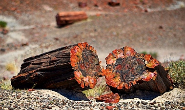
Jim Gray's Petrified Wood
Company.

Petrified logs ready for splitting.

Geodes ready for opening.

Dinosaur country!

They're cute, just don't get bit.


Petrified Forest National Park.

A tree trunk that has cracked into drums.

Agate House.

They built 'em small in 1200 AD

The National Park calls these rock structures "teepees."

Collared lizard on a petrified log.

Cows watch us approach.

Puerco Pueblo housed 1,200 people.

A stork carrying a baby, for sure!!

Santa Fe Railroad.


A rusting relic near the old Route 66.

Painted Desert.
Mogollon Rim & Petrified Forest National Park
April-May, 2012 - It took us a few days to decompress after our awe inspiring three
weeks in inland Chiapas. We had studied Spanish in colonial San Cristóbal, seen
Mayan ruins in Palenque, Yaxchilán and Bonampak, and visited sparkling waterfalls
at Agua Azul and Misol-Ha. But we had received alarming news while in the jungle
that Mark's parents had unexpectedly taken very ill. Their prognosis for survival had
become bleaker by the day.
We scrapped our plans to
sail 200 miles further to El
Salvador where a rollicking
annual rally of 50 boats was
in full swing, and instead
prepared our boat Groovy for a six month wait at Marina Chiapas while
we made a hasty retreat back to Mark's family homestead in Michigan.
It was jarring and disorienting to rejoin
modern American life after months of
immersion in southern Mexican culture.
Far more upsetting, however, was suddenly finding ourselves face-to-face with the specter of
death. We passionately pursue our dreams everyday, always feeling the immense pressure of
time, but now the grim reaper was at the door trying to collect. For days we huddled inside the
drab sterile walls of a modern health care facility trying to be positive while pondering the
incomprehensible.
Fortunately, spring was in full bloom outside. Flowers were bursting with
color everywhere, and flowering trees seemed to grace every front yard.
Every time we stepped outside we were greeted by the cheerful image
of tulips, a heartwarming flower neither of us had seen for years.
Very gradually, and totally miraculously, both of Mark's parents began to
recover and were able to return home. As they gained strength we did
too, and the dark, raw emotions in our hearts began to ease. Out in a
friend's garden a cluster of bleeding hearts reminded us that often the
most precious things in life are also the most fragile, and that life itself is
a gift we receive every day.
When we eventually returned to our own hometown in Phoenix, Arizona, we
found spring had sprung there too. Our beloved saguaro cactuses were
wearing their little springtime crowns of white flowers on every limb.
Just a few weeks earlier an ancient saguaro in a friend's
yard had died and toppled over. It now held the fledgling
chicks of a starling that had moved into her condo when
the cactus was still upright.
Despite living in a house that was now eight inches from the ground,
not a great spot for a small bird, she bravely got those chicks raised to
adolescence, and in no time they had all moved out.
We got our trailer out of storage, dusted it off, and set up camp at
nearby Roosevelt Lake. Still recovering from all that had gone on, and
feeling a bit battle weary, we reveled in watching a cardinal come to
our little seed plate every day. We could have stayed for a month, but unfortunately the desert temps
were climbing and soon became intolerable.
Fortunately, just 80 miles north of Phoenix we found ideal temps
up on the Mogollon Rim (pronounce "Mugeeyone"). At 7500'
we were in the cool pines, and we found a camping spot right on
the edge of the rim with views to the valley floor far below.
The rim is a jagged shelf of flat rocks that stick out in layers.
The views are expansive and the smell of the ponderosa pines
is invigorating. There is something about the edge of the rim
that is very alluring and draws people to it, even though the
sheer drop-off is a little unnerving. At all the scenic overlooks
everyone gets out of their cars and walks right out to the edge
to take in the view and get a photo.
While we were there four huge forest fires were
burning in the valley below us. The Gladiator Fire
made the national news, and we saw the hotshot
firefighting team's base camp nearby. Firefighters
had been flown in from all over the country to help
out, and some 1,000 people were fighting the
blaze. The smoke was intense
at one point, and it billowed
over us like a huge wave.
That evening the sun was
almost totally obscured by the
smoke. But the hotshots
managed to wrestle all the
fires under control, and in just
a few days the air was clear
again.
We discovered a wonderful
paved trail that runs along the
edge of the rim for a few miles.
Luckily for us, it had just been
lengthened by a mile. The edge of the rim
is magical, and at every rock outcropping
we found ourselves stopping to get another
look. This same trail also heads into the
forest towards Woods Canyon Lake where
it weaves past several campgrounds. We
rode our bikes along the trail and savored
the crisp air and pretty views.
Spring was happening up here too. The
pines were all adorned with their new
feathery soft needles, and we found flowers
that looked like wild irises growing in a
meadow.
We passed a mother elk
sitting under a tree
chewing her cud. Nearby
her young calf was
hanging out chewing its
cud too. They were
totally indifferent to our
presence -- or to that of
the cars that had started
to stack up in the road as
everyone grabbed their
cameras and jumped out
for photos. We stood
there for quite some time
watching the mouths of
these two large animals slowly working around and
around while their gazes wandered calmly between us
and the cars. It was as if they were kids hanging around
at the street corner, chewing gum, and waiting for
something to happen.
Woods Canyon Lake is cool and serene, surrounded
by pines. Families were out fishing and an energetic
guy rowed a skull back and forth.
We stayed in this beautiful mountain forest
for two weeks, settling into our homestead
as if it were our own private mountain home.
Every day we ran, biked and walked. Then
we read, napped, played on the internet and
watched the boob tube, something we hadn't
done for eight months. Isn't it amazing, we
kept saying to each other, that we can get 12
Phoenix digital TV stations via our antenna
and good internet from our nifty new Verizon
MiFi unit, while we are camped several miles
down a dirt road deep in the woods on the
edge of a cliff?!
It was hard to leave, but once we
got the wheels rolling on our
buggy, we couldn't wait to get out
and see our beautiful country. Our
first stop was the Petrified Forest
National Park. Actually, we
stopped just before the National
Park because the guy who owns
the vast acreage next door has
been mining petrified logs from as
deep as 30' down in the ground for
decades, and the collection he has
on display and for sale at his store
"Jim Gray's Petrified Wood Company" is astonishing.
Petrified logs are created when a log gets buried in sediment, preventing rot, and then becomes
infiltrated by silica in the groundwater, replacing its organic material. This stuff eventually
crystallizes and "petrifies" the whole log. Over time, as erosion peels the ground out from under
the log, it cracks into short drum-shaped pieces that for all the world look like they are ready for
splitting.
We wandered through the
endless display of petrified logs
and even found a pile of geodes
out back. This pile stood almost
10' tall and maybe 30' around at
the base. What a treasure trove!
This is also dinosaur country,
and the local gift shops have all
kinds of fun making crazy
displays for tourists. Mark found
a few out by the geodes.
Petrified Forest National Park is an easy park to miss
inadvertently because it sits on a road that cuts between an
Arizona highway and an interstate. We had made that mistake
years ago. We had driven along at 55 mph waiting to see a
Forest, and we skipped the pullouts because there was no
evidence there was any Forest there. After an hour we emerged
at the other end of the park having seen nothing but wide plains
and a few scattered logs in the distance. That goof-up has been
a standing joke between us ever since.
The only way to see this national park is to get out
and do some hikes. The hilly field behind the
visitors center is strewn with huge logs, many
resting in a row and fitting together to make an
entire tree trunk. These things are massively heavy
and are 8 times harder to cut than granite. From a
distance the crystalized bark, knots and tree rings
look lifelike, but up close the agate colors merge
and swirl in non-treelike patterns.
We hiked on the Long Logs trail which features one tree
trunk after another, each one segmented into shorter
logs that lie end-to-end. Looking around the sweeping,
empty, grassy plains it is hard to imagine that 260 million
years ago this area was a logjam in an ancient riverbed,
back when all the continents were joined and Arizona's
latitude was somewhere around modern day Panama.
13 species of large but extinct pines forested the area.
Out at the Agate House we
found an ancient Indian
pueblo made of petrified
wood pieces. Archaeologists
believe it was constructed
between 1050 and 1300 AD.
Those guys built very small
buildings.
The trail took us past tall,
horizontally striped "sand
piles" that are now solid
stone. It looked like a gravel
yard that had been carefully
layered in different types of gravel. The heights of the
dark stripes matched from one pile to the next. There is
an otherworldly quality to this landscape.
As we walked back to the
truck Mark spotted a collared
lizard sitting on a hunk of
petrified wood. His little pink
mouth seemed to be grinning,
and his long skinny tail trailed
almost twice his body length
behind him.
This is cattle ranching country
too, and before we could get
to the petrified log that spans a chasm -- the Agate Bridge -- we had to
get past a group of cows standing in the middle of the road. These
guys didn't move an inch as we drove past. Only their heads turned to
watch us as our enormous truck and trailer nearly brushed them when
we drove by.
The Puerco Pueblo hike took us to an ancient Indian settlement built
around 1250 AD. It was home to some 1,200 people. 6'x8' was a typical
room size, and unlike the mammoth Mayan and Zapotec buildings we'd
seen a few thousand miles to the south, these ruined walls have been
reconstructed to
just a foot in height.
Far more intriguing
for us were the
petroglyphs that the
ancients had
pecked into the nearby rocks. One showed what
looked to me like a stork carrying a baby. I'm sure
the archaeologists would disagree about that, but
these images are often a bit like ink blots -- what
you see in them is up to you.
The park road crosses I-40 and deposits visitors in
the middle of the Painted Desert. But first you get a glimpse of the
Santa Fe railroad and some relics of the old Route 66. While we
were wandering the hiking trails closest to I-40 we kept hearing
the horns and rumbles of endlessly long trains rolling past. I
climbed up on a bridge overlooking the tracks and caught a train
as it approached. Running to the other side I watched it
disappear around the bend. These tracks date back to 1882
when the Atlantic and Pacific Railroad went through. Early visitors
to the park arrived by train and took guided tours hosted by the
Fred Harvey company.
Mark was fascinated by an ancient rusting hulk of a car
that had been abandoned long ago on the side of the
old Route 66. Stretching 2,200 miles from Chicago to
Los Angeles, that historic road passed right through
this area, bringing tourists to the park in their own
private cars instead of by train. Now this part of Route
66 is overgrown by prairie grasses.
Our final miles along the park road
took us past some incredible vistas
overlooking the Painted Desert. This is
a colorful area of more gravel-pit
looking solid stone "sand piles," and
we had taken so long
getting through the park
that we arrived while the
late afternoon sun was
lighting the vivid
landscape to its most
brilliant hues. Gazing out
at this exotic land, the
sun beating down on us
and our sinuses rapidly
shriveling up in the dry air, it was hard to imagine what the ancients or the early
settlers must have thought or how they even survived. So harsh and yet so
beautiful.
By now our spirits were fully restored. As we studied our maps we decided to
head north via the tiny squiggle labeled "Indian Route 12" and head towards
Canyon de Chelly National Park. This road was marked as a scenic route
but despite being Arizona residents before our traveling lifestyle we had never
heard of it before.
Cedar Breaks National Monument in Utah – Better Than Bryce?

Sweeping views at Cedar Breaks.


Fluffy clouds drifted above us.

Happy campers.


Red rock hoodoos with arches.

The trail winds through lush
greenery.

Columbines.

Indian paintbrush.

A chipmunk nibbles bluebells.


"Place where the rocks are sliding
down all the time."


Spectra Point.

1,600 year old bristlecone pine tree.

Gnarled old fellas.

A young fawn looks up as we pass.

Chessmen Overlook.

North View Lookout.

Cedar Breaks is known for
wildflowers.


Redrocks through the trees.

Millions of years old, the canyon weathers all.


Thick green carpet on the Alpine Pond
Loop Trail.

Alpine Pond.

Nature's graffiti.

The Upper Loop wanders through a meadow.

Colorful wildflowers.

Wild strawberry.

Last glimpse of the red rocks.

Reflections on the Alpine Pond Trail.
Cedar Breaks National Monument, Utah
Mid-August, 2011 - Visiting Cedar Breaks National
Monument was the main reason we came to Dixie National
Forest but, sidetracked by caves and canyons, it took us a
while to get there. Vastly overshadowed by nearby Zion,
Bryce Canyon and Grand Canyon National Parks, a lot of
folks are like us and only hear about it from a ranger or
other traveler once they get to this area. Years ago we had
stopped by for an hour on a quickie drive-by. This time we
wanted to hike the two hikes and see the canyon up close.
Perched nearly in the clouds at 10,350' elevation, the wildflower-lined
winding road seemed to climb forever before we got to the park.
Intrigued by the sign for the Spectra Point overlook in the parking lot,
we went straight up that path when we arrived, not knowing we were
venturing out on a 2-mile round-trip hike.
WIthin minutes we were staring at a wonderland of red rock spires
and hoodoos. The puffy clouds floated by above us, casting
shadows across the red rock "amphitheater." Red, pink, white and
orange rocks in crazy shapes filled the view in all directions, and
bristly pine trees speckled the distant cliffs
The trail wanders along the rim of
the canyon, weaving in and out of
lush greenery. There are no railings
or gates to obstruct the view, and
we felt as though we were
suspended above an orange
fairytale town.
Wildflowers bloomed alongside the
trail: white columbines and red
indian paintbrush flowers begged to
be photographed.
A little chipmunk
sat contentedly in
a thicket of
bluebells and ate
them for lunch.
We made very little forward progress as we kept stopping to take in the views,
admire the colorful wildflowers and chat with other people on the trail.
Many people were at the canyon that day somewhat by
accident, as it hadn't been on their original itinerary. One
fellow had had car trouble while visiting Zion and Bryce and
had asked the mechanic how to keep his family entertained
while waiting for the several-day repairs to be completed.
"Go to Cedar Breaks!" He was so happy to have discovered
this park; his kids were running ahead of him down the path,
excited to get to the overlook.
A 1,600 year old
bristlecone pine
tree stands near the
end of Spectra
Point, thriving in a barren, windwhipped and
hopelessly exposed spot. The wood is striated
beautiful shades of orange and brown, and a few
scraggly branches prove to the world that the
seemingly lifeless giant is truly alive and well.
The sun felt warm on our skin as we walked,
but the brisk wind that swept across the
canyon was a sharp reminder of just how
cold this area can be. A ranger told us that
the park usually gets 15' of snow each winter,
but last winter was buried 30 feet deep.
On our way back we noticed a doe eating the flowers, and then
behind her we saw her fawn.
As we drove out of the park we stopped at Chessmen overlook
and the North View Lookout. Stunning. Amazing. It's impossible to find words to
describe the vastness, the vivid color, the exotic contours and shapes of this beautiful
land.
Earlier residents of this area were the Paiute Indians, and they named the canyon, "Place
where the rocks are sliding down all the time." After that the Spanish explorers
misidentified the juniper trees as cedars (much as they did on Isla Cedros off of Mexico's
Baja Pacific coast). The word "breaks" refers to the steep, eroded landscape.
Cedar Breaks is known as much for its glorious wildflower
displays as it is for its majestic red rock amphitheater.
We returned on another day to hike
the Alpine Pond Loop Trail, and
found ourselves snapping shots of
the many brilliant wildflowers before
we even got to the trailhead.
Lupines and daisies and a myriad of
other flowers lay thickly on the green
brush surrounding the trail. The hum
of bees and mosquitos was very loud
too, and the lush land seemed to be
teeming with life.
Oddly, the forest of tall pine trees shading the
wildflowers is largely dead. In past years the
energetic National Forest Service extinguished all
wildfires within hours of them starting. The result was
an unhealthy forest dominated by one species of tree.
Those trees provided the most awesome feast for the
bark beetles that like to eat them, and in the past
decade the beetles have munched their way through
the woods, transforming the living pine
canopy into a pin-cushion of dead trunks and
branches.
Between the dead branches you can glimpse
the red rock canyon, however. The spires,
nooks and crannies of that spectacular
landscape are utterly impervious to the
comings and goings of trees upon the
surface.
Eventually we arrived at the alpine
pond. It wasn't the crystal clear kind
of lake we have seen at Yosemite
and other places, but it had its
charm.
Some of the dead tree
trunks had been carved
by Nature's graffiti
artists -- little worms
made all kinds of
patterns in the wood.
We had started on
the Lower Trail
which is lush and
green and closed-
in feeling. We
returned on the
Upper Trail which
takes the hiker out
across a wide
meadow filled with
flowers. The peak of the wildflower
season in Cedar Breaks is the final weeks
of July and perhaps the first week of
August. We were a little behind the peak,
so the blanket wasn't quite as thick with
color. But it was plenty
beautiful enough for me.
Mark has a green thumb
and cultivated strawberries
at one time, so he instantly
recognized the shape of
wild strawberry leaves
among the other greens.
"Strawberries!" He cried,
and then he spotted a beautiful tiny red ripe one, about a half inch
across. We left it for whatever bird or bunny might come that way.
The trail gave us one final glimpse of the red
rocks of Cedar Breaks and then we were
back at the truck.
Mark's parting shot was the reflection he saw
in my sunglasses. He came up to me really
close and said, "Oh, that looks really cool!" I
thought he was sweeping in for a kiss, but
suddenly he stopped, put his camera up and
snapped a picture. I made a face at him,
and then, being a romantic, he swooped in
for a real kiss.
Looking for more red rock adventure and a slightly lower altitude, we wandered 30 miles or so north along the incomparably
scenic Route 89 to the Red Canyon area.
Wupatki Nat’l Monument – Ancient Indian Ruins & Great Camping in AZ!

Flagstaff's San Francisco peaks seen across the meadow outside Bonito Campground.

Coconino Forest's ponderosa pine woods.

Wildflowers at Bonito.


San Francisco peaks.

Bonito Campground.


The meadow that used to be filled with
sunflowers is now parched and cracked.

Some sunflowers line the road.


Sunset Crater just before a downpour.

Looking down at Nalakihu from Citadel Pueblo.

Nalakihu Pueblo.

Lomaki Box Canyon dwellings.

View from inside Wupatki Pueblo.


Lomaki Box Canyon dwellings.

Lomaki Pueblo.

Lomaki Pueblo.

Looking out at the high desert plains from Citadel Pueblo.

Wupatki Pueblo and its round Kiva (gathering place).

Wupatki Pueblo, home for about 100 people.

Mark plays with the blow hole's breezes.

Our picnic is cut short by looming black skies.

Lightning!
Bonito Campground & Wupatki Nat'l Monument, Flagstaff, AZ
August, 2011 - We crossed the Sea of Cortez from just north of Bahía Concepción on the Baja side of Mexico to San Carlos on
the mainland side in late June, a 75 mile jaunt. It was the very best sailing day in our entire seven months spent cruising the
Mexican coast: bright sunny skies, flat seas, and a sprightly wind drawing us along on a close reach. Our arrival in San Carlos was
the first step of our re-entry into civilization and the US, and each stage of re-entry was a shock.
Perhaps the most jarring
moment in this process was our
first trip to a Super Frys
supermarket in Phoenix. What a
staggering abundance of
gorgeous produce, so beautifully
presented and in such perfect
condition! Mark and I stood and
stared in amazement, mouths
open in awe. "Where's my
camera?" I cried. Our friends
thought we were nuts.
Getting to Phoenix from San
Carlos required an 11 hour bus ride,
and we then returned to San Carlos by
truck (a mere eight hour drive) to deliver
some things to the boat and relieve the
boat of other things
we didn't need any
more (winter
clothing!).
Then over the next
six weeks we
skidded from being
merely bone tired to
being utterly
exhausted as we ticked off the endless items on our "to do" list of
chores. We lived as perennial house guests, bouncing between
generous friends' homes.
The madness culminated with finding new tenants for our
townhouse. Sleeping on an air mattress in our empty
townhouse during a frantic week of repainting the interior, we
realized we had come full circle. Four years of traveling, with
only the briefest visits to Phoenix, and here we were back in
our townhouse again, surrounded by the same smells, the
same noises, the same sensations that had been the essence
of our old home. What had the last four years meant? Had we
grown or just taken a big detour through life? There was no
time to think about that; there were chores to do!
Once our
responsibilities were
behind us, we grabbed
the trailer out of
storage and dashed up
to Flagstaff as fast as
we could go. We made
a beeline for Bonito
Campground, our all-
time favorite
campground. Despite
being die-hard
boondockers, we splurged on a weeklong stay there while we re-familiarized
ourselves with the RV lifestyle and restocked the trailer with everything we had
pillaged from it for the boat.
Here at 7000' elevation we finally began to take stock and get some perspective on all
that we'd been through. When we left Phoenix in 2007, real estate was peaking at
astronomical prices. Now, on our return, there was a sea of homes in various stages
of financial distress and foreclosure. Few real estate signs were visible, however. The
panic was largely on paper and online, and too often was manifested in midnight
moves. Some of our once-wealthy friends were now scrambling to pick up the pieces
of their lives, while other less well-heeled friends were suddenly able to afford
gorgeous homes.
The city's everpresent, massive
expansion into the outlying pristine
desert was temporarily on hold while it adjusted to the new economy. Our
memories of Phoenix as it once was were overlaid onto Phoenix as it is today,
and there were areas where the images meshed, and areas where they were
like two different places.
Some of the changes were within ourselves as well. Our souls were the same,
but all this traveling had expanded our knowledge of the lands around us, and
we had come to know ourselves better too. These thoughts swirled around us
as we rested and strolled about Bonito's pretty grounds. Life aboard Groovy in
Mexico felt like a far distant dream.
The land surrounding Bonito Campground has changed too. Last year this part
of Coconino National Forest was devastated by the Schultz wildfire which wiped out some
15,000 acres, mostly on the area's mountain slopes. Campers at Bonito were evacuated
twice, first to escape the fire and later to avoid the erosion-caused floods. As a ranger
explained to us, the floods altered the landscape forever and
even moved floodplains. Many nearby homes were damaged
or lost, a young girl drowned, and the water rose to about 8' in
the campground's amphitheater, leaving the place buried in
sludge.
Knowing some of this before we arrived, it was with trepidation
that we approached the campground. The meadow that is
usually teeming with bright yellow sunflowers at this time of
year was devoid of blooms and parched and cracked in
places. But what a thrill it was to see and smell our beloved
ponderosa pine woods. Bonito's soul is the same, just singed
a bit here and there. The wildflowers still line the edges of the
roads and promise to return to the meadows. The
hummingbirds still buzz the campers looking for easy
meals in feeders. Some ponderosas have blackened
trunks, but the tops are green.
However, the Schultz fire was
nothing compared to the volcano
that erupted at next-door Sunset
Crater around 1050 AD. Spewing
marble-to-football sized chunks of
rock into the air for a few months
(or possibly several years), the
evacuation of the local farmers
lasted for generations. The
volcano layered the land for many
miles around in a thick blanket of
cinder. In its last moments it spat
out a final burst of cinder that was oxidized to a rust color. This gives the mountain a distinctive
orange-red top to this day, and the sun and shadows spend their days playing with the color.
We took a drive through the
nearby Indian ruins at Wupatki
National Monument. These
were built 50-100 years after
the eruption by the so-called
Sinagua people who returned
to the area to find that the
blanket of volcanic ash now
helped keep rare moisture in
the soil. They somehow eked out a farm life, living essentially
"sin agua" or "without water."
The ruins are like tiny dots on vast open plains, each located
several miles apart. The San Francisco mountains line the
horizon, but there are few trees or other protection between the open lands and the sky.
We opted to start at the far end of the drive, visiting the more remote
ruins first. These were built above small box canyons that are
essentially ditches in the ground bounded on two or three sides by 100'
rock cliffs. The cliffs provide the only weather protection in the area.
The Sinagua people understood real estate: location location location.
It was early
morning and utterly
silent. The
crunching of my
feet on the gravel paths made the cottontail
bunnies run, and lizards of all shapes and
sizes scurried for cover under rocks along
the trail. We were the only visitors at each
ruin, lending a sense of magic to each
place.
At the biggest ruin, Wupatki Pueblo,
Mark played with the natural
"blow hole" air vent. The
National Park Service has built
a structure around it, but the
blow-hole itself is the real deal,
blowing air out or sucking it in
depending on ambient
temperatures and air pressures.
As we returned to the
campground the sky turned
black, thunder rolled and
lightning streaked the sky. For
seven months on the boat in
Mexico we hadn't seen a single
drop of rain. The deluge that came now was fantastic.
We drove through it
laughing, barely able to
see the road ahead, and
we jumped back in the
trailer, glad to have real
shelter. It was so great to
be back in our RV lifestyle
again. The rain pummeled
our roof all afternoon, and
we fell asleep to the plink
plink plink of raindrops
overhead. Little did we
know the downpours
would continue for several days. The sun finally returned in full blaze
as we took off to head north to Dixie National Forest in Utah.
Other great RV camping areas:
- Lost Dutchman State Park: GORGEOUS scenery & RV campground!
- Windy Hill Campground + Tonto National Monument
- Lynx Lake, Arizona – Great RV Camping Near Prescott!
- Dead Horse Ranch State Park + Tuzigoot and Clarkdale
- Catalina State Park & Roosevelt Lake: RV Camping in AZ
- Oliver Lee Memorial State Park, New Mexico – A Dog’s Eye View!
- Lost Dutchman State Park Campground – Arizona Gold in the Superstitions
- Lake Pleasant & Canyon Lake – Waterfront Camping in Arizona’s Sonoran Desert
- Sand Hollow State Park, Utah – An Oasis in the Desert!
- RV Camping with the Rock Art Petroglyphs in Gila Bend, AZ
- City of Rocks State Park, NM – RV Camping in the Hoodoos!
- Boondocking at Big Bend National Park – Cheap & Scenic RV Camping
- Roosevelt Lake – Lakeside Camping in AZ
- Wupatki Nat’l Monument – Ancient Indian Ruins & Great Camping in AZ!
- Valley of Fire, NV – A Cauldron Cooled
- Zion NP, Kodachrome Basin & Snow Canyon, UT – Great Red Rocks!
- Goblin Valley, UT – Where the Ghosts Are
Our most recent posts:
- Buckskin Mountain State Park – Fun on the Colorado River! 01/31/26
- How to Install Starlink Gen 3 in an RV? Use the Speedmount! 08/07/25
- Escape to Paradise – Rocky Mountain Magic! 08/01/25
- Is Forest River a Good RV? Well Built? Here’s Our Experience 06/20/25
- Sunset Crater Nat’l Monument – Lava & Camels at Bonito CG! 06/06/25
More of our Latest Posts are in the MENU.
New to this site? Visit RVers Start Here to find where we keep all the good stuff!!
Natchez Trace Parkway, MS – A Scenic Drive with No Trucks Allowed!

Welcome back to Natchez Trace

The Trace is perfect for a leisurely drive

We took a spin on the bikes

Wildflowers lined the road

A motorcycle group enjoys a morning ride

We take a side road to visit an Indian Mound

Riding down the side of the Indian Mound

A barn in the distance

This split-rail fence had no joinery - the rails were simply
laid on top of each other

Cows in the distance

Bursts of color everywhere


A lone tulip celebrates the
morning
Natchez Trace Parkway, Mississippi
March 20-21, 2009 - We reluctantly tore ourselves away from the sparkling waters
and soft sands of the Emerald Coast and made our way north.
We could have stayed on that beach forever, but we had two problems in the trailer
that needed attention. From day one our stove had acted up: if you cooked
something for a long time, eventually the burner knob wouldn't turn and you couldn't
adjust the flame. This meant that it was just about impossible to shift a pot from a
rolling boil to a gentle simmer.
Also, the sliding pocket
door that separated the
main room from the
bedroom had fallen off its
track. Neither of these
repairs was something
that Mark wanted to
tackle, especially
since the trailer was
still under warranty.
So we decided to
make a trip to the
NuWa factory in
Chanute, Kansas,
where the experts
were.
This change of plans
meant we would
retrace our steps
from last year,
traveling up through Alabama and Mississippi through Arkansas to the
southeast corner of Kansas. Poking around on the map we were happy
to see that this put the free campground at Rocky Springs on the
Natchez Trace right in our path.
The Natchez Trace is paradise for anyone that likes the simple pleasure
of going for a drive. It's a place to meander and ponder rather than a
route to get you somewhere. There aren't a lot of dazzling sights, but
there are endless miles of peaceful scenery with minimal traffic, clean
pavement and sweeping turns. It is ideal for bikes, motorcycles and cars that aren't in a hurry.
We rolled out our bikes and took a leisurely ride out and back along 15
miles of the Trace south of the campground. The air was fresh and clear,
flowers sprinkled the edges of the road with vibrant colors, and we
murmured to each other for the umpteen-millionth time, "What a great life!"
The Trace is layered in history, from prehistoric peoples to more
recent Indian cultures to the early settlers to modern America. The
ancestors of the Natchez Indian tribe lived along the route, and
evidence of their unusual customs has been found in their ancient
burial mounds. One Indian mound in particular had caught my
attention last year, and we took the little side route off the
Trace to see it once again.
There is not much to see but a small grassy hill topped with
informational plaques. However, their tales took my breath
away. Apparently the ancients had a radically different view
of the sanctity of human life than we do today. When a noble
man died, his slaves were strangled and buried with him. Far
more shocking, when a parent died, sometimes the surviving
parent killed their children as a sign of respect and grief.
It is easy from our viewpoint at this time in history to dismiss those
customs as barbaric, cruel, and unfair. However, in their society it
was somehow right and good and proper. Where our society would
have screamed "Murder!," theirs might have been nodding solemnly,
saying, "Yes, that was the right thing to do."
This was all very heady stuff, stamped out in a few brief
sentences on rusting metal National Park Service plaques placed
around the mound. The violent acts of the early peoples were
hard to fathom in such a bucolic setting. In the distance, the
cows were munching the grass, a barn stood quietly against the
treeline, and a split rail fence snaked its way across the meadow.
All around us the spring flowers were
bursting with color. Yellows, pinks
and pale blues filled the fields.
If you looked really closely, some of
the tiniest little blooms were the most
elaborate, but as a group they
formed a carpet of color.
Back at the campground, right outside the bathrooms, a
single tulip was opening up and greeting the day. How could
that bulb have possibly gotten there? There wasn't another tulip for miles around. It seemed yet
another mystery in this very mysterious place.
We said goodbye to the people we'd met at the campground, a young woman riding her bike
down the Trace for Spring Break and an older grey bearded guy on a motorcycle going the other
way. A little more north off the Trace for us, and we would soon find ourselves in the Ozarks.
Bryce Canyon, UT – Fairyland of Pink Turrets

Inspiration Point overlooking Bryce Ampitheater

Bryce Canyon Point

Smiles everywhere


Natural symmetry

The regularity and precision of
these formations can be dizzying.

Trees cling to the rim

Bryce Ampitheater


Beginning of Queen's Garden hike

The spires give way to a smooth, orange and red
moonscape

Trees from another planet

End of the trail -- at Queen's
Garden

Nature's Wall Street

The top of the Wall Street switch backs


Bryce Lodge has many cute cabins for guests

The Peek-a-boo hike defies nature's laws and seems
to ascend for the entire loop.

Serenity

Spires and spikey trees surrounded
us

Peek-a-boo

At times it seemed as though we were wandering
among towering chess pieces.

A promontory hangs into the canyon for an awe
inspiring view. A good place to take a breather!

Little tunnels and hobbit doorways invite the hiker to
vast views on the other side.
Bryce Canyon National Park, Utah
July 20-August 20, 2008 - We had
arrived in the lower elevations of
Kanab, UT and visited Best
during a peak week of monsoon
activity. Monsoons are a
southwest phenomenon that give
the desert's much needed
moisture and relief from the heat
in mid-summer. I had learned
about them living in Arizona, but
had never known that they could
spread their salve as far north as
southern Utah and even over into
southern Colorado. It is magic to
watch the sky cloud over promptly
at noon every day, and there is a
lusciousness to being drenched
by brief downpours every
afternoon. These storms leave
the air crisp and clear, and they
keep the ferocious heat to a minimum. Once the monsoons abated, we
found ourselves in an oven, baking by noon, and burnt to a crisp by
evening. Full of energy at the break of day, we were lethargic sloths by
nightfall. It was time to get back to the higher elevations. We left Kanab
for Ruby's Inn, a settlement just outside of Bryce Canyon National Park at
7,500 feet.
Bryce Canyon
is a wonderland of pink and white
spires, laid out with amazing
symmetry. The open bowl of
crystalline formations carved from
the surrounding flat plains
resembles an ampitheater. The
man who first ranched the area
around Rubys Inn in the 1800's
had no idea the canyon was just
beyond his land. Imagine the
look on his face when, at the
suggestion of a knowledgeable
neighbor, he took his family on an
excursion to the rim! It is a place that evokes smiles
in everyone, and as we rode the shuttle bus to the
view points and walked the many trails that lead
along the edge and down into the canyon, I was
struck by how happy everyone was. Children love
this place.
We walked along the Rim, from
Bryce Point to Inspiration Point,
and watched a fantastic summer
thunderstorm creep over the
valley until we had to run for
cover ourselves. This land was
carved by a divine hand using the
tools of wind and rain to erode the
rock into fantastic formations. I
was awed by the regularity of the
carvings. Rows upon rows of
spires stand in perfect military
formation.
At the top the
trees cling to the rim for dear life,
their roots clawing at the
crumbling gravel as their
branches wave ominously in the
breeze, threatening to rip the
trees from the edge. At the
bottom the trees pierce the air
above them, the dark green
spikes contrasting with the
orange and white striped spears
of rock.
We hiked down into the canyon to
the Queen's Garden. As you descend on this hike,
the land becomes otherworldly. Between the spires,
the land forms smooth, rounded slopes and the
trees are short and twisted. The noise of the
tourists at the rim fades away behind you and the
solitude and odd surroundings seem like a
moonscape. The emotional
anchor of the ordinary looking
grassy fields and ranches that
surround Bryce Canyon
disappear from view, and you
find yourself on the moon, or
mars, looking up at the red rock
spires, repeating the mantra:
"Wow!"
The gravel path winds in and out
of the spires, abandoning one
spectacular sight as it takes a
sharp turn around a bend
towards another. We walked
through several doorways and
tunnels, emerging from each to
find ourselves staring at yet
another splendid work of art by
Nature. People linger on these
trails. Llittle groups and pairs line
themselves up for photos, posing
all over this spectacular setting.
Cameras are handed around
trustingly between strangers in
order to get everyone in each
group into the pictures. "I'll take
one for you if you'll take one for
me," is the phrase of the day,
sometimes said in broken English,
and often accompanied with gestures and sign language. Cameras are all
shapes and sizes. "Just press the button." Lots of nodding and pointing.
Everyone is grinning. None of us can wait to show these pictures to our
friends back home. All the photos turn out great.
At the very bottom we came to a plaque that showed us
Queen Victoria. This was the Queen's Garden. She is
at the tippy top of a spire. She looks very regal, and
very wee. In time she will erode away and be replaced
by other shapes. Looking around at the other hoodoo
rock formations, we made out a medieval friar and a
great horned owl to accompany the queen.
We had descended about a thousand feet and had to
climb back up again to the rim. We chose the route that
goes through Wall Street, where the red rock walls
close around you like skyscrapers but much closer. A
switchback trail takes you up until you look way down
on the tiny pine trees at the base. Then you climb
higher til the people seem mere specks. Your heart
pounds from the exertion of climbing
straight up, and when you reach the
top the view takes your breath away
yet again.
We wandered along the rim and met
a little girl holding a camera that was
as big as she was. What a smile she
had as that camera clicked away.
The Bryce Canyon Lodge is the
oldest original National Park lodge still
standing; the others at Yellowstone,
Grand Canyon and the rest all
succombed to fire at one time or
another and were rebuilt. Bryce isn't immune to
wildfires, however, and there were many "prescribed
burns" in action while we were there as the Park Service
attempted to keep the woods thinned so they wouldn't
be prone to future fires.
We spent a few days riding our bikes and hiking in the
areas away from Bryce Canyon and then returned to do
the Peek-a-boo hike. We were both surprised at how
the grins came back to our faces and the "wow" formed
on our lips again as soon as we walked up to the rim.
What a place.
We had no idea why the Peek-a-boo hike has its name,
and we descended into the canyon away from the
crowds wondering what laid
ahead.
Once again, as we walked down
into the canyon, we felt an
almost physical sensation cloak
our bodies as the immense quiet and peace of this place enveloped us.
Suddenly, we looked up at a wall of spires and saw one hole, and then
another. "So that's why it's called Peek-a-boo!" Mark said, mugging for
the camera. We walked with our heads up and our eyes on the peaks,
tripping occasionally. But you can't look down on this hike, even as you
stumble.
The trail
twisted and turned and double-backed on itself between formations. I
felt like a rat in a maze, or a child stomping around on an enormous
chessboard.
We did a lot of climbing on this hike, more than seemed physically
possible for a loop hike. Mark walked faster than I did (he didn't
bring his camera and mine kept slowing me down!), and I turned a
corner and looked up to see him happily surveying the view from
an ideal vantage point. Once I caught up to him we sat together
for a moment.
When we turned to continue on, we were facing a little doorway. As we passed through the door
to the glittering view on the other side, I felt like Dorothy as she steps out of her Kansas house
into the colorful Land of OZ.
After a few weeks at our "ranch
house" outside of Bryce Canyon,
among the cattle, ponderosa pines
and pronghorn, overlooking grazing
lands that stretched to the horizon,
we felt like it was home. Our TV got
great NBC reception, so we stayed to
watch most of the Beijing Olympics. It
was very hard to tear ourselves away,
but eventually the day came, and
once we hit the road, the excitement
of discovering new places propelled us forward and made us eager to
leave. We bumped into the sweet village of Alton and gradually made
our way over the mountains to Parowan and Cedar City.
Subscribe
Never miss a post — it’s free!
More info about Bryce Canyon National Park:
- Bryce Canyon National Park Official Website – National Park Service Website
- Maps of Bryce Canyon National Park – National Park Service Maps
- Location of Bryce Canyon National Park – Google Maps
- RV/Tent Campgrounds in Bryce Canyon – Dry camping for small / medium RVs inside the National Park
- Ruby’s Inn RV Park – Full hookups and Big Rig Friendly in nearby Bryce Canyon City
- Red Canyon Campground – Beautiful dry camping with 6-8 campsites big enough for our 36′ fifth wheel trailer.
More blog posts from our RV trips to Bryce Canyon
- Bryce Canyon in Winter – Snow and Lace on the Red Rock Spires! 01/25/19
- Spring in Sarasota FL + Bryce Canyon’s Night Skies – in Trailer Life 04/04/17
- Bryce Canyon – Rainbow Point – Bristlecone Pines and Sweeping Vistas 11/01/16
- Bryce Canyon National Park – “Mossy Cave” – Mystery Waterfall! 10/18/16
- Red Canyon Utah and the Bryce Canyon Bike Trail! 10/13/16
- Bryce Canyon Gone Wild – Tempests, Rainbows & Wildlife 10/09/16
- Bryce Canyon National Park – Fairyland Trail – A Beautiful Hike! 10/02/16
- Bryce Canyon – Hiking The Rim & Navajo Loop + A Tourist Time-lapse! 09/29/16
- Bryce Canyon National Park – Inspiration Point – OMG! 09/27/16
- Bryce Canyon, UT – Fairyland of Pink Turrets 08/25/08
Related posts from our RV travels:
- Our RV travels in Southwestern Utah – Bryce, Zion and Capitol Reef area
- Our RV travels in Southeastern Utah – Moab, Arches, and Canyonlands area
- Our RV travels to Sedona Arizona – Red Rock Country in AZ
- Our travels to North America’s National Parks – National Parks and World Heritage Sites in the US, Canada and Mexico
Our most recent posts:
- Buckskin Mountain State Park – Fun on the Colorado River! 01/31/26
- How to Install Starlink Gen 3 in an RV? Use the Speedmount! 08/07/25
- Escape to Paradise – Rocky Mountain Magic! 08/01/25
- Is Forest River a Good RV? Well Built? Here’s Our Experience 06/20/25
- Sunset Crater Nat’l Monument – Lava & Camels at Bonito CG! 06/06/25
More of our Latest Posts are in the MENU.
New to this site? Visit RVers Start Here to find where we keep all the good stuff!!
Grand Canyon’s North Rim – Its Better Half?

The road to the North Rim winds through meadows.

Monsoon season was just starting.

A little piece of heaven camping in the Kaibab
National Forest.

Western Tanager

Vista Encantada

Angel's Window

Cape Royal

Cliff Rose

Cape Royal

Cape Royal

Walhalla Lookout

The North Rim Lodge has
exceptional views.

Sofa Room at the Lodge

Lodge Dining Room

Sun Porch at the Lodge

Bright Angel Point trail


Bright Angel Point

Bright Angel Point

Hiking in the Kaibab forest

We came across a clearing overflowing with lupines.


The aspens cluster together.


Point imperial Lookout

Imperial Point

Ken Patrick Trail from Point Imperial
Grand Canyon - North Rim
June 24 - July 13, 2008 - We left Flagstaff in search of cooler weather,
and we found that and much more at the North Rim of the Grand
Canyon. The road from Jacob Lake to the North Rim is 44 miles of
graceful beauty.
After descending through dense woods, some of which were badly
burned in a wildfire in 2005, the road shakes out its curves, the tall
pines step back, and you fly along through lush meadows. These
meadows were green when we arrived in June, but by the time we left
in July there were wildflowers of all colors scattered about. The
elevation in this part of the world hovers between 8,500 and 9,000
feet, making the warm summer season very short. When we first arrived the sun was abundant and the air was warm.
By the time we left the summer monsoons were in full swing, bringing
thick, black storm clouds every afternoon. You could almost set your
clock by the 2:00 thunderstorms. We camped in a little forest glade
that was pure heaven. Our only neighbors were a jackrabbit and a
deer, both of which made several appearances, and a gorgeous male
western tanager who appeared near the end of our stay. Our little
clearing was lined with aspen that quivered whenever the wind blew.
Our first evening in our little paradise we watched the sun set while
listening to John Denver sing about nature. The warblers chimed in and
the aspen seemed to laugh and
dance in the orange glow of the
setting sun. It was magic.
Our first trip to the Rim itself took us
on the farthest reaching road,
passing Vista Encantada and taking
us down to Angel's Window and
Cape Royal. Vista Encantada was
bursting with wildflowers. Yellows,
oranges and even the bright pink of a prickly pear cactus flower
enhanced the rust reds of the canyon. The North Rim is not heavily
visited, and we were the only people at this lookout, gazing at the jaw-
dropping vistas while clicking away on the cameras.
Cape Royal, a massive lookout area, lies at the end of this road.
There is a charming paved walking trail through the scrub brush and
woods that leads out to Angel's Window as well as Cape Royal. We
couldn't believe that we were the only ones on the trail. Angel's
Window gives you a glimpse of the Colorado River if you peak
through, but once you climb onto the top of this arch formation you
get an unobstructed view.
As we walked we were overcome with the sweetest fragrance. A
trailside plaque told us that the Cliff Rose was responsible for this
heady aroma. We breathed deeply and walked slowly. We were
here at the perfect time of
year.
Returning towards the
buggy, we stopped at some
of the viewpoints we had
skipped on our way out.
Walhalla Lookout is the
gathering place for a daily
ranger talk about the
ancients who lived in this
region, growing crops on a plateau 5,000 feet below at the Colorado River in the winter and moving up to the Rim in the summer.
There were some Indian ruins from 800 years ago, including a granary where they stored seeds for future planting. From where
we stood we could easily see Mt. Humphreys in the San Francisco Peaks back in Flagstaff. A 200 mile drive by car, the mountain
was just 50 miles away as the condor flies. I watched the clouds gathering over Mt. Humphreys as the afternoon monsoons began
to build, and suddenly I understood why the Indians have always viewed the mountain as sacred. From that hot, dry plateau way
down on the Colorado River, it would be only natural to believe that the mountain held a mystical power to create clouds and rain.
Those clouds and their life-giving moisture drifted over the canyon
and a light rain began to fall.
Another morning we walked the Transept Trail from the campground
to the North Rim Lodge. This dirt path hugs the rim and occasionally
peaks out at a view that grows broader and broader as you approach
the Lodge.
The Lodge was built in 1928 and reflects the
elegance and simplicity of that earlier time. It is a
stone and timber structure with enormous windows
overlooking the stunning view. In the early days
visitors were greeted by singing staff members, and
the first view they got of the canyon was through
the immense windows that drew them across the
wide lobby floor. Those windows are equally
alluring today, and comfy leather sofas fill the
room.
A beautiful dining room also
has towering windows that
look out at Canyon views,
and it is impossible not to
feel a tie to the past when
seated beneath these
chandeliers.
The Lodge also has a
sunporch with open-air
seating in front of the
spectacular view. What a
place to enjoy a latte, soak in
the view, and maybe even
read the paper.
From the Lodge we wandered out on the paved Bright Angel Point
trail. This is a pretty walk that takes you to the very end of the
peninsula that the North Rim Village is built on.
We clambered up onto the towering rocks to check out the many
views. At the end you can see the widest part of the Canyon laid out
before you, stretching 21 miles to the South Rim. We were able to
make out the tower at Desert View but couldn't see the other buildings
on the South Rim. The immensity, colors and shapes were a feast for
the eyes.
We felt very blessed
to be able to stay in
the area for three
weeks. After each
visit to the Rim we
would spend a day or
two back at the trailer
looking at our photos,
absorbing the
experience. There is
a lot to see in the
Kaibab National
Forest as well, and
we did a lot of cycling
and hiking, checking out
the maze of dirt roads in
the area.
As we stayed more and
more flowers began to bloom
and on one hike we found
ourselves in a lush bed of
lupines. There was a variety
of shapes and hues, and we
came back to this area
several times to enjoy the
rich colors. A little further
down this road we found bunches of
yellow flowers that grew in clumps, like
nature's perfect little bouquets.
Mark noticed these little black butterflies
zipping around us periodically, and one
finally stopped long enough for him to
get its picture.
We drove out to Point Imperial
and hiked a portion of the Ken
Patrick trail to the south. From
that viewpoint you can see the
Little Colorado River in the
distance. It is a sheer canyon
that looks like a crack in the flat
landscape. It almost looks like a
child took a stick and dragged it
across the sand in jagged motions,
leaving a deep trench in its wake.
Point Imperial is not hard to miss.
As we walked along the trail we saw
it shrinking in the distance behind
us. There were many wonderful old
trees and tiny yellow and red
flowers along the route. We felt so
grateful to be alive to be able
to experience these wonders.
It was hard to leave our little paradise in the
woods at the Grand Canyon, but the monsoons
turned nasty and we found ourselves in
sweatshirts and long pants for several days in a
row. We even got hailed on twice -- pea-sized
hail that piled up on the ground for an hour
before melting. We hadn't seen everything at the
North Rim, but we always leave a few discoveries
for future visits. We wanted to head a little
further north towards Kanab and Bryce Canyon
in Utah.
Sunset Crater, AZ – Looks Like it Exploded Yesterday!

Getting weighed

Campsite at Bonito in Flagstaff.

Boondocking in the Cinder Hills OHV Area

Solar panel installation


Sunset Crater erupted 800 years ago

Smooth cinder hills alongside the road

Cinder hills and lava flow

San Francisco Peaks

Cinders are black gravel and red gravel

San Francisco Peaks


View from the top of the Lava Flow Trail hike


Vermillion Cliffs near Lees Ferry


Neat spot for a house!

Vermillion Cliffs - many colors in the rocks


Start of the climb out of the desert up to the Kaibab Plateau
Sunset Crater National Monument, Arizona
June 4-24, 2008 - We drove from Chanute, Kansas to Flagstaff, Arizona (1,200
miles) in just 3 days. We stopped long enough to weigh the truck and trailer at a
Flying J truck scale and found we were right at the limit. Even though we had filled
only 1/3 of the cabinet space, our weight (with water and propane) was 13,850 lbs --
and the GVWR (Gross Vehicle Weight Rating) is 13,995 lbs. No wonder the truck
noticed the load!! This wasn't the little Lynx any longer! We had met a lot of fifth
wheel owners whose cabinets and closets were stuffed to overflowing. They must
run about 2,000 lbs or more over their GVWR.
As we traveled across
country the air got dryer
and the terrain got craggier. On I-40 in Texas, 10 miles west of the
New Mexico border, there was a very distinct transition from open
plains to a desert landscape. We had left tornado alley in the middle
of tornado season and we were glad to leave the severe storm
warnings and tornado watches behind. However we drove straight
into a vicious headwind all the way across the country, and in New
Mexico and Arizona the winds were staggering. We were paying far
more for gas than we ever had -- and we were getting 8.2 miles per
gallon!!
At an Arizona
visitors center
we heard
another fifth wheel driver discussing routes to Wasington with the host,
trying to find a way to get out of the horrible winds. Not possible! When
we arrived in Flagstaff it felt good to be among the tall pines under clear
blue skies again. The winds eventually subsided, and we relaxed at our
favorite campground northeast of Flagstaff, Bonito Campground. We
retired the truck for a while, sticking to our bikes as much as possible.
Flagstaff has a fantastic store for solar power related items (Northern
Arizona Wind and Sun), and just like the previous year, we used our
time in town to purchase a complete solar setup. We upgraded to
490 watts of power (from 130) and a permanently installed pure sine
wave inverter. We boondocked in the Cinder Hills OHV Area and
Mark took his time installing the new panels on the roof and the
charge controller and inverter in the basement. After three days it
was done, and the system has been phenomenal ever since.
Wherever we are, it is always as if we have full electrical hookups.
The hummingbirds loved our feeder, and we
enjoyed watching them zip around. One
morning a pair of warblers came to the feeder
for a visit. Their beaks weren't shaped quite
right for the feeder, so they didn't stick around,
but I was thrilled to get their picture through
the window.
We took some leisurely bike rides through
Sunset Crater National Monument. This is a beautiful area for cycling, as there is no traffic and the road is smooth and scenic.
Sunset Crater blew its top 800 years ago, filling the skies and covering the ground with cinder ash. The cinder ash (black gravel) is
so thick that little can grow in it. This makes the area seem as though the volcano erupted just a few years back. The cinder hills
seem smooth from a distance, and there are places where the gravel is actually black sand. In other spots the black gives way to
shades of red and brown, again making it seem as though this mountain were engulfed in volcanic flames sometime within my own
lifetime. There is a region where the lava flowed, and today it is an impenetrable strip of sharp black rock. If you look closely you
can almost see the ripples and waves as this thick angry goo washed down from the mountain.
In the distance the San Francisco peaks were still snow capped.
Standing over 12,000 feet high, the tallest of the peaks is easily visible
from the North Rim of the Grand Canyon some one hundred miles
away as the condor flies. The Navajo and other native peoples have
long felt that the San Francisco peaks were sacred. I had never really
understood exactly why until a few weeks later when we were camped
on the North Rim and were looking back at these peaks across the
canyon. Every afternoon, like clockwork, the clouds would begin to
form over Mt. Humphreys. There was no doubt that those mountains
attracted -- or were even the source -- of rain. Looking down at the
barren plateau on the Colorado River at the bottom of the Canyon I
could understand why the ancients revered that distant mountain. It
brought them much needed water for their crops.
We took a hike with friends up the Lava Flow Trail and
found some spectacular views of the San Francisco
peaks and the valleys surrounding the mountains. It
was a steep but short climb up the hill and well worth
the view at the top.
When we first arrived in Flagstaff the overnight
temperatures were in the 30's and daytime highs were
in the high 60's. After a few weeks the highs were
getting into the 90's. Even boondocked in total shade
(we found it was a miracle that the solar panels still
fully charged the batteries everyday despite being in
full shade!), we were too hot. It was time to move on
to somewhere cooler.
We headed to the North Rim of the Grand Canyon. It
is a significant drive to get there. Even though
condors and intrepid hikers
can cross the chasm in just 21
miles, it is a 200 mile trip by
car, because you have to go
way to the east, then a bunch
north, way to the west, and
then drop south to get there.
The drive takes you through
some beautiful desert
areas. The Vemillion
Cliffs are stunning, jutting
up out of the desert floor
in vibrant shades of
orange, red, and even
turquoise. There is little
in the way of towns on
this drive, just occasional
hamlets with perhaps a
store and cluster of
trailers. We drove with
our eyes glued to the
beautiful scenery.
After taking the big left turn near Lees Ferry to head west, the red desert
suddenly gives way to greenery and you begin a steep and winding climb
up onto the Kaibab Plateau. The desert floor is at about 4,000 feet
elevation and the top of the Kaibab Plateau is at about 9,000 feet. North
Rim here we come!!
Natchez Trace Parkway, MS – Echoes of History!

Natchez Trace Parkway

The Old Trace

Mount Locust "stand"


Dining room - with seating for 6

Parents' bedroom

10 kids slept here (5 in each bed?!)

Grandmother and eldest daughter slept here.

Driveway to Stanfield

Stanfield, where Andrew Jackson was married.

Rocky Springs Campground

Rocky Springs:
Population 1860 - 2,616
Population Today - 0

Bank vault

Rocky Springs Church, built 1837

Rocky Springs Graveyard


French Camp


Natchez Trace & Jim Henson Museum, Mississippi
April 29-May 2, 2008 - We left Natchez and ventured onto the Natchez
Trace Parkway, a 444 mile road that follows a primitive trail linking
Natchez, Mississippi with Nashville, Tennesse. The Parkway is a
remarkable two lane road that is closed to commercial traffic and has a
speed limit of 50 mph. The National Park Service oversees the Parkway
and maintains three free campgrounds along its length. Because of the
low speed limit the traffic is non-
existent and we often drove for many
miles without seeing another vehicle.
There is a lot of history along the
Trace and at times it felt like we were
viewing layers of history. We saw
Indian burial mounds from 4,000
years ago and travelers' "stands" or
inns from 150 years ago.
The original Trace was created by buffalo and other animals migrating north-south. The ancient
peoples used the trail for their own migrations. In the 1700's European traders would bring furs
and other goods down the Mississippi by boat, sell their goods in Natchez (and even sell their
boat for lumber) and then walk back to Nashville and other points north to do it again.
The Trace became a popular
place for highway robbers, as the
folks walking north from Natchez
had money in their pockets and
little protection. In the early 1800's, seeking to bind the vast and
turbulent frontier to its northeast seat of power, President Jefferson
ordered the army to widen the trail and make it a road passable by
wagon.
As was noted by the Secretary of State at the time, "the passage of
mail from Natchez is as tedious as from Europe when westerly winds
prevail." The Trace vastly improved communications, but by 1830 it
fell into disuse as steamboats going up and down the Mississippi
river offered easier transportation. The Natchez Trace Parkway
weaves along the original Trace route. At times the original Trace is
visible. It is a mere hiking trail. After the Trace was built into a road,
"stands" or inns popped up along the route. These offered food and
lodging to travelers -- on a very simple scale.
We visited the Mount
Locust stand. A family
operated this stand with
51 slaves. In the main
house the parents slept
in one bedroom. The
grandmother and eldest
daughter in another.
The other ten kids slept
in the remaining
bedroom. The
mattresses were made
of corn husks and rope.
Visitors made do on the
porch.
Looking at these
cramped
accommodations it was
hard to imagine that
arriving at one of these
stands was all that
inviting. However, after
walking or riding a horse
all day on a dirt trail
these intrepid travelers must have been accustomed to truly roughing it.
Nothing like us, with our motorized transport, smooth paved roads to drive on
and a buggy with a well stocked fridge, freezer, hot shower and 12 inch mattress.
We stopped briefly at Stanfield, the mansion where Andrew Jackson was married.
Like others we had visited, there was a long tree-lined drive up to the house, and
the house was a
pillared beauty.
At Rocky Springs Campground, one of three lovely and free
campgrounds on the Trace, we were treated to a gorgeous morning
with filtered sunlight pouring through the trees.
On the edge of this
campground is the
ghost town of Rocky
Springs. All that
remains of this once
bustling town is the church, the graveyard and two bank vaults. The abandoned
bank vaults reminded me of the vault we had seen in the Gulf Coast town of Bay
St. Louis, MS. However, the once prosperous rural town of Rocky Springs wasn't
devastated by a hurricane. Instead its death came from many sources: bad land
management that cleared hillsides for cotton leaving
erosion scars that can be seen today, the Civil War, a
yellow fever epidemic in 1878 and a boll weevil infestation.
It was eerie to walk a small trail through the woods where
there had once been cotton plantations and 2,616 residents.
There is nothing but trees now.
Up on the hill the church is still used, but
the cemetery's stones all date from the
1800's. How can a town vanish in just a
little over 100 years?
Port Gibson is one of the larger towns at
the southern end of the Trace. At one
time it was considered "too beautiful to
burn," but we didn't find it particularly
inspiring. There was an interesting mural
on the wall of one building, and a small street with a handful of
stores, some in business and some shuttered. More intriguing were
the homes on the outskirts of town where the Confederate flag was
flying. Some flew the flag along with the American flag, and some
flew it alone.
We took advantage of this ideal area for cycling to do a few rides along
the Trace. With no noticeable traffic, modest rollers, and interesting
historical sites every few miles, we thoroughly enjoyed our rides. One
day, while camped further north on the Trace at Jeff Busby
Campground, we rode our bikes down to French Camp. This was a
bustling community in earlier days and had several pretty buildings.
Besides the recent historical sites that can be seen on Natchez
Trace, there are a lot of prehistorical sites as well. We stopped
at several Indian ceremonial and burial mounds. Archaeologists
have dug through these mounds and made some startling
discoveries. At one site, when the leader of the tribe died it
seemed that all his attendants were killed and buried with him.
Often they were killed by strangulation. Likewise, when a parent
died sometimes the rest of the family would be strangled and
buried with the parent. As I pondered all this back at the
campground -- in the pretty setting sun -- it occurred to me that even though lots of people have concerns about individual rights in
our culture today, at least we don't do that.
After we left the Natchez Trace Parkway we headed west and
north towards Arkansas. I was dozing when suddenly Mark
said, "Look, Kermit the Frog...!" I woke up just in time to see a
billboard for the Jim Henson museum. We spent a very happy
hour at this little outpost in Leland, Mississippi that is a
charming museum of Jim Henson memorabilia. It is run as a
labor of love by a woman who raised her children watching
Sesame Street.
I remember when that television show first aired in 1969. As a
nine-year-old its alphabet and numbers lessons were a little
juvenile, but I remember loving the gentle humor and I
watched it for many hours with my younger sister.
Mark knew the show from raising his kids watching it. He had been a
teenager when it first aired, so he never saw the episodes I did. It was
amusing standing around with the proprietor and realizing that all three
of us had watched it during different eras and we remembered different
things -- even different muppet characters.
This little stop in Leland rounded out a delightful visit to Mississippi.
From there it was on to the Ozarks in Arkansas.