This is Page 2 of our collection of tips for cruising Mexico in your own boat (see Tips for Cruising Mexico - Part 1
and Mexico Maps for more info). These are things we learned en-route and wish we had known before we left. If you are
planning a cruise to Mexico, I hope this special page from our boat blog helps paint the picture of what you might find there.
• Checking In Procedures:
What you might experience during the check-in process
• Money:
Currency exchange and credit cards
• Provisioning:
Stores and foods
• Boat Parts:
What to expect - it's nothing like the US or Canada
• Internet Access:
UPDATE from 08/25/2016 - See INTERNET info at bottom of page!!
• Laundry:
Where to do it and what it costs
• Clothes
What kinds of clothes - and how much - to bring
• Hair Care
Getting your hair done can be a cultural experience
• Bugs:
There aren't many, but here are the few we've seen
• Dinghy/outboard Theft
Crime against tourists is rare, but dinghy/outboard theft is a known problem in two areas.
• Costs:
Approximate costs of cruising in Mexico
• Hurricane Season
Some things we learned after leaving our boat in San Carlos
CHECKING IN
This procedure changes so much it is almost silly to put anything in here, as it is probably out of date already. But this will give
you an idea of what might take place, as it is what we went through in February 2010 and October 2010…
We checked into Mexico in Ensenada. This is a great place to do it, as everything is in one room. In 2010 the Ensenada
marinas charged $60 to have a staff person take you to the port captain and walk you through the process, although we have a
friend who was not charged a centavo. Having a guide makes it a no brainer to check in, and you know everything is done right.
If you decide to do it yourself you will still need the marina to write up a crew list for you. The port captain in Ensenada wants to
see the letterhead of one of the three local marinas on the crew list. I tried to write one myself upon our second entry into
Mexico after we had left for the summer and they wouldn't accept it. The port is encouraging all boats not to anchor out, so this
may be part of their method for controlling that.
Your marina may write up a crew list for free, at least Baja Naval did for us when we checked into Mexico the second time.
They will also ask you to give them a copy of the paperwork when you get back from the port captain's office. It is a tightly
controlled port and the marinas are required to keep copies of the check-in paperwork for boats that stay with them. All
together you will need:
• Crew List
• Passports for all on board
• US Coast Guard boat documentation
• Boat insurance declaration page (I think…)
• Serial numbers of your boat's main engine and dinghy outboard
The port captain's office is on the north side of the big fish market at the north end of the malecón. It is down a side road,
opposite the chandlery Agencia Arjona, and is clearly marked "Capitania de Puerto." Ask for directions when you get to the fish
market.
Walk inside and tell the first person you see that you want to check in. There are several windows with officials sitting behind
them, and you will be pointed to the right one for starting the process.
You will be obtaining a 10-year Temporary Import Permit ("TIP") for your boat and a 6-month tourist visa for each person on the
boat. For each of these documents you will have to pay first at one window (the Banjercito) and then take your receipt to
another window to obtain the paperwork. You may go back and forth between the windows twice to get these documents
completed.
The TIP is a document that includes an addendum page that lists everything you have on your boat, including watermaker,
electronics, cooking appliances, etc. This is where the serial numbers of the engines comes in. We knew we would be adding
solar and a watermaker within a few months, so we listed the boat as having those already.
At the end of the whole process you will have three documents in your hand: 10-year TIP, Tourist visa(s), and stamped Crew
List. In addition you will have the two receipts from the Banjercito (TIP and tourist visa(s)). The process could take an hour or
could take two, as it did for us because we walked in right after a megayacht that had 10 New Zealanders on board.
Then you will be asked to press a magic button that is connected to a large street light. If it lights up green you are good to go.
If it lights up red and sirens go off, you will be mortified and everyone in the room will stare at you. This means you have been
arbitrarily selected for a boat inspection. A few uniformed people with clipboards will accompany you back to the boat and will
have a look around. They checked out our boat but didn't verify line-by-line what was on the TIP as I would have expected. It
was just a general, friendly inspection, much like the many Mexican Navy boardings that have taken place since then.
MONEY
There are lots of places to get the current exchange rate between the Mexican peso and US or Canadian dollar. One site with a
historical perspective and current rate is: http://www.x-rates.com/d/MXN/USD/graph120.html. Although in the past two years
the exchange rate has hovered between 11 and 13 pesos to 1 USD, most people use a 10-to-1 exchange rate in their heads
when trying to figure out prices on the fly.
The best place to change money is with your debit card at ATM machines located
within bank buildings. By using a bank's ATM machine you have someone to go to if
the machine doesn't give you your money (three different friends have told me a
free-standing Mexican ATM machine shorted them their money or gave them nothing
at all, and they had little recourse). You can't exchange money with a bank teller
unless you have an account at the bank, and the money changers on the streets
don't give great rates.
You will be charged a fee by the bank that changes your money, usually about 19-27
pesos, and unless you bank has a relationship with the Mexican bank, your bank will likely charge a $2-$3 fee too. So we prefer
to change as much money as possible whenever we do it (6,000 to 8,000 pesos seems typical with most cruisers I've talked to),
and the final exchange rate after the two sets of fees works out to about a few tenths of a peso less than the advertised rate.
The receipts never show the exchange rate you were given, so we find out what rate we got when we look at our bank account
online after the fact.
HSBC, Bancomer, Banamex, Santander and Scotiabank are in most cities. I haven't studied the comparative exchange rates,
but I do know in La Paz HSBC gives the best rate. One interesting note: I walked into a Santander bank and the first ATM
machine I walked up to wanted to charge 31 pesos to change money, while the second one, further from the door, charged only
21 pesos.
Credit card fraud is rampant in Mexico. In one year we had five cases of fraud on three different credit cards. I guess it took us
a while to learn our lesson. So bottom line: don't use your credit card. Our last fraud was either at an Ensenada marina or at
the main TelCel office in Ensenada, so even if you are dealing with an established, above-the-board big business, your card
may get compromised. Look up "ATM skimmers" or "credit card skimmers" online to learn more about some of the ways credit
card fraud is accomplished, both at US bank ATM machines and abroad.
All that being said, it can still be helpful to have a credit card available for emergencies or for purchases where you trust the
merchant. Most credit cards charge a fee for changing the currency from pesos to US dollars. However, Capital One credit
cards are terrific for all international travel because they do not charge any kind of a fee for changing money.
You will need lots of smaller bills when you are in smaller towns -- 20, 50 and 100 peso notes. We have found some places are
challenged to make change when you hand them a 200 peso note. Lots of 2, 5 and 10 peso coins are also handy for tipping. If
the ATM machine gives you a wad of 500 peso notes, go inside the bank and get some small ones.
FOOD & PROVISIONING
Warehouse Stores
There are some warehouse stores on the Mexican coast. Sams Club is more prevalent in the coastal port towns than Costco.
The only coastal Costcos are in Cabo San Lucas, Puerto Vallarta and Acapulco. The one in PV is very difficult to get to,
especially if you are staying in La Cruz, as there is no bus to it. The cab ride back to La Cruz from that Costco is about 100
pesos ($7.50). Sam's Club is much more common in coastal Mexico (Manzanillo, Puerto Vallarta, Mazatlan and La Paz) and is
relatively easy to reach in every town. Before buying or renewing your club card, check the Mexican locations online, as new
Costcos and Sams Clubs will continue to pop up.
Supermarkets
There are lots of big supermarkets in the major cities (Ensenada, La Paz, Loreto, San Carlos,
Mazatlan, Puerto Vallarta, Manzanillo, Zihuatanejo). The Mexican chains are Soriana,
Comercial Mexicana (which has a line of mammoth supermarkets called "MEGA") and Ley.
Walmart is in most of those cities too. If you need to do a big provisioning run, take the bus
there and a cab back. Most cab rides are around 30 to 50 pesos ($2.30-$3.80). Negotiate the
fare before you hop in.
The selection and prices are all over the map, both in the warehouse stores and in the major
supermarkets. American packaged products are often more expensive than in the US due to
import taxes. Some brands have a big presence in Mexico and some are non-existent. For
instance, Kelloggs cereals are everywhere, some General Mills products are re-branded Nestle,
a handful of Quaker cereals can be found and Post cereals don't exist at all. If you have certain
products you can't live without, stock up before leaving the US. If you are willing to take the time
in the bigger cities, you can find just about everything if you check each of the big supermarkets.
Soriana and Comercial Mexicana (Mega) both have
club cards for frequent shoppers. It is easy to sign up
for a card and you will accumulate points. Every so
often it pays off. I've never fully grasped the subtleties
of these cards, but a few times we've had a hundred or
so pesos deducted from our grocery bill at the checkout
counter.
It is customary to tip the bagger a few pesos for bagging your groceries. I have
heard rumors that they are not paid by the stores, but I don't know if this is really
true. Also, we purchased two big insulated "cold bags" and keep some cold packs
in our freezer. This helps keep the refrigerated items cold during the long trek
back to the boat.
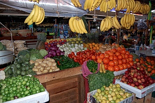
Public Markets
Many bigger towns have a Mercado Publico -- a central public
market. These usually take up nearly a city block and are enclosed
with lots of booths for different vendors. The meat, fish, poultry and
produce is brought in from the outlying farms. Prices aren't posted,
so it's a great time to practice your Spanish numbers as you ask
what different items cost. You bag what you want and pay the
person near the booth's register. Often lots of other things are for
sale -- there might be a hat booth, a straw basket booth, a hardware
booth, a broom booth, a DVD booth, etc. For us gringos, it can feel like a
very third world experience, but is also very colorful and exciting.
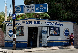
Small Grocery Stores
In smaller towns, villages and on the back streets of the cities you'll find corner "tiendas" or
"abarrotes." These are small convenience stores and grocery stores that carry essentials.
These little one-room shops usually have a few vegetables (onions, potatoes, tomatoes, and
maybe a few others), lots of canned goods, bread, boxed milk, soaps, cold drinks, bottled water,
beer and other basics. They are often called a "mini-super."
There are US-style convenience store chains as well. Oxxo is the most common convenience
store chain. Similar to 7-11 or Circle K, it can be found on many city street corners. The beer
breweries also have chains of convenience stores that sell their beer and other basics. Modelo,
Pacifico and Tecate all have convenience stores. For Corona fans: Modelo makes Corona.
Dollar Stores
There are dollar stores in Mexico. The most common are Waldo's ("Todo a un precio" - "Everything at one
price") and Solo Un Precio. Just like dollar stores in the US, they sell all kinds of cheap goodies. This is one of
the few places we have found pretzels, although they are not quite as tasty as pretzels you buy in the US. We
also found huge jars of peanut-butter and relatively inexpensive peanuts.
Provisioning before leaving the US
Specialty items, from favorite toiletries to spices, sauces and condiments, may or may not available in Mexico, so stock up on
those before you leave. Kikkoman soy sauce is easy to find, but Neutrogena facial products aren't. It's impossible to list all that
is available and not available. This is where living in Ensenada for a few months first (or at least driving or taking the bus down
for a weekend to check out the shopping situation) is really helpful
Don't bring any canned vegetables with you except what you are going to consume right away. Canned vegetables can be
found in even the tiniest "tienda" in the most remote Sea of Cortez village, so unless you eat a lot of canned vegetables, there is
no need to bring any with you from the US. Other canned goods like Dinty Moore Beef Stew, Chef Boyardi products, Bush's
Baked Beans and Hormel Chili are not easy to find. Canned tuna and canned chicken are reported to taste different in Mexico.
I can't verify that as I am still working on the enormous stash we bought at Costco before we left the US.
Paper products in Mexico are not the quality we are used to in the US. If you use a lot of paper towels and like them to be
strong enough not to disintegrate at first touch, take as many rolls as you can fit. We have friends who now use blue Shop
Towels as paper towels (available at auto parts stores in Mexico) -- an expensive way to go, but they couldn't stand the flimsy
Mexican paper towels. Likewise with toilet paper. Good quality brands of these products can be found at the warehouse stores,
but not necessarily at the supermarkets.
We found we longed for American snack foods, and were glad to have a stash of favorites. Ritz crackers,
potato chips and Oreos are readily available at supermarkets in Mexico, but Wheat Thins, Cheezits,
Triscuits, and Chips Ahoy are nearly impossible to find. Dark Chocolate, Peanut Butter Pretzels and Nuts
of any kind are rare and expensive.
If you have a freezer, stock up on meats, chicken and your favorite cheese before leaving the US. The
Mexican counterparts are okay, but they are different, and it is really nice after a few months to bite into a
steak from your favorite hometown grocer.
Get some long-life veggie bags. Debbie Meyer's Green Bags or the Brawny pink ones. Both keep veggies
longer than if they are in regular plastic bags. You can wash and re-use the bags. We had beautiful fresh
broccoli 3 weeks after we bought it in San Diego. Carrots, potatoes and onions last well in brown paper
bags out of the fridge.
Provisioning in Mexico
Many big city supermarkets have a gringo section, and that is often stocked with Kirkland
(Costco) brand items, although the prices are more than in the US. Breton crackers, fancy
mustards and olives can often be found on these shelves. I've even seen peanut-butter pretzels.
Mexican dairy products are not the same as in the US. For some reason the fresh milk goes
sour a lot faster -- is it inferior processing, or does the US use more potent chemicals? Who
knows. Mark stopped eating cold cereal all together and I use boxed milk for my coffee. I don't
taste a difference. To me the boxed milk is just like fresh milk, but Mark disagrees
wholeheartedly.
If you like yogurt, the best yogurt we have found is from the dairy Alpura. This brand is sold
primarily on the mainland, but sometimes you can get lucky in Baja. All plain yogurt by other companies
has sugar in it ("azúcar" in the ingredients list). Alpura is the only dairy that sells true plain yogurt. Their
flavored yogurt is also the most similar to US yogurt. Even though Yoplait and Dannon sell yogurt in
Mexico, it is nothing like the US versions of the products.
If you want fat free products, that is "sin grasa," and sugar free is "sin azúcar." Many people confuse
yogurt and sour cream because the containers look the same. If the container says "Crema" it is sour
cream. If it says something that looks like the word "yogurt" (spellings vary) then it is yogurt.
There is one major Mexican cheese sold everywhere: Manchego cheese. It has a Spanish origin where
it is made from goat milk. In Mexico it is a different recipe using cow's milk/cream. It is a white cheese
that is good with crackers or in quesadillas or tortillas. However, many Americans eventually long for their
familiar orange cheddar cheese which Mexicans don't eat. Most supermarkets carry one brand of cheddar cheese: Joseph's
Farm from California. Stock up when you see it, if you like that kind of cheese, as other gringos will be stocking up too, and a lot
of times the supermarkets are sold out. Most big city supermarkets sell Gouda cheese and many have Brie and other soft
European cheeses as well.
Also in the dairy section you can always find Yakult, a terrific little sweet dairy drink packed with
probiotics, the perfect antidote to any kind of gastric distress caused by Montezuma or anything else.
We have never gotten sick from water or food -- only from swallowing red tide by accident. Most
digestive complaints from cruisers seem to come after a meal out.
The biggest supermarkets have good selections of fresh produce. However, the quality is not as high
as the US. Examine everything carefully, because blemishes are common. Most big supermarkets
sell small bottles of Microdyn or other antibacterial wash products. Pour a cap-full in a sink of water
and let all the veggies float in it for a while. Then rinse them well.
Eggs are often sold unrefrigerated. They can be kept unrefrigerated if you turn the box over every 24
hours. I had never in my life seen a rotten egg before living in Mexico. I cracked my first one not long
ago. The yolk and white were completely black and putrid. Now I understand the childhood taunt,
"Last one home is a rotten egg."
Meats and chicken take a little getting used to, as the quality is often only so-so. The chicken is very yellow. We have asked
lots of people why, and we've gotten several odd answers. There is an old wive's tale that it is from feeding the chickens
marigolds. Well, Mexican chickens are raised in factory farms, so that is doubtful. Some say they are dipped in iodine. I've also
heard they are fed corn, but US chicken is fed corn too. Who knows. It is very yellow and it can have a potent smell when
cooked if you don't remove the skin and fat.
Lunch meat is available in one variety: turkey ("pavo") that has been made to look like ham ("jamón"). The most common
brand is "Fud." It resembles the worst quality lunch meat available in US stores, and even that brand name "Fud" is
unappetizing. If you like good quality lunch meat, buy a bunch in the US, freeze it and bring it south with you.
Fresh fish is often a better bet. The Spanish names are different. Fish we have enjoyed immensely are Cabrilla (bass) and
Sierra (Spanish Mackerel), as well as dorado (mahi-mahi).
Pollo Asado is grilled chicken sold at outdoor stands. This chicken is delicious. Choose a stand that has a crowd of Mexicans
around it, and it will be tasty and safe to eat. A whole chicken is usually around 100 pesos ($7.50) and you can also buy half
and quarter chickens. They are often split along the sternum and laid out flat on the grill so they look like roadkill. They are sold
with corn tortillas and often with delicious flavored rice. This is a terrific thing to buy prior to a long passage. You can nibble the
chicken plain, make chicken salad or sandwiches, turn it into a stir-fry, or wrap it in a tortilla with cheese and heat it up.
Tacos on the street are also a great way to go for cheap eats. A good price is about 8 to 20 pesos per taco (around $0.60 to
$1.50). Two makes a meal and three stuff you. They are served open so you can fill them with toppings and then roll them up
yourself. Always choose places that are crowded with Mexicans. They know where the good food is. Carne, chicken and fish
tacos are available from Puerto Vallarta and to the north. The best are on the Baja peninsula (at Rancho Viejo in La Paz and
Las Brisas in Ensenada).
South of Cabo Corrientes corn tortillas begin to dominate and flour tortillas disappear along with the familiar style of beef,
chicken and fish tacos found up north. It is not nearly as easy in this area to find good beef taco stands. In Manzanillo we
walked all over town in search of fish tacos and finally asked at the visitors center where to find them. They sent us to a back
street where a vendor had a vat of fish stew he ladled into corn tortillas -- not at all the fish tacos we were used to in northern
Mexico and southern California and Arizona.
You can easily make fish tacos from any kind of cooked fish by dicing up tomatoes and cold crunchy veggies (cucumber, celery,
cabbage, etc.). Heat up the fish on a tortilla in a skillet or microwave, then sprinkle on the veggies and add a little mayo and hot
sauce and roll it up. Yum.
The best flour tortillas are on the Baja peninsula, and are found in tortillerias that make them there on the spot. They are
typically about a peso apiece, sold by the kilo (about 28 tortillas). Separate them before refrigerating or they will stick together
and rip. If you freeze them they may stick together when thawed, so separate first and make sure they are dry before freezing.
South of Cabo Corrientes there is only one brand of commercial flour tortillas, "Tortillinas," and they aren't nearly as good as the
homemade ones, but they are sold even in the smallest tiendas. Tortillerias in this southern coastal part of Mexico make and
sell only corn tortillas.
Totopos are a fried corn tortilla chip snack food that were probably the original ancestor of Doritos and Fritos (we discovered
that the famous Frito Bandito song from the old commercials is actually a take off on a famous Mariachi song here in Mexico).
They are available primarily on the mainland. You can buy them freshly made at tortillerias and in the bakery section of the big
city supermarkets, or you can buy them prepackaged at little corner tiendas. They are tasty as a snack served plain or with a
guacamole, bean, cheese or other dip.
We have found awesome refried beans under the brand "Isadora" that come in soft
plastic packaging. These are fantastic for a quickie bean burrito on the boat (tortilla,
beans, cheese, hot sauce - heat and roll up).
Mayonnaise also comes in this kind of soft packaging which is perfect for jamming
into a packed fridge…
It is hard to find good quality coffee in the northern part of Mexico. However, the
best coffee I have ever had can be found at The Octopus's Garden / Galeria Huichol in
La Cruz (Puerto Vallarta/Banderas Bay). The proprietor, a Frenchman named Wendy,
roasts his own beans to create a French Roast that is to die for and is about half the
price of Starbucks coffee in the US. He also sells his coffee at the weekly Farmer's
Market in La Cruz and is located in the last booth that sells coffee (so don't get hasty
and buy the wrong stuff!). Further south in Zihuatanejo you can get locally grown
Mexican coffee, and it is very good.
There are lots of products I have been told can't be found in Mexico, but they can be if you are patient. They just
aren't easy to find and may not be in the city where you want them to be. But keep prowling around and eventually
you will locate them. Among these are brown sugar, pickle relish and high quality packaged bread.
BOAT PARTS
While all Mexicans eat and there is an abundance of food to be had, even if it isn't quite what you're used to at home, not that
many Mexicans own cruising boats. Finding parts for the boat is a challenge. Even finding simple tools and hardware is a
challenge.
The best chandlery we've seen is Lopez Marine in La Paz. It is about ⅓ the size
of West Marine in San Diego. If they don't have it on the shelf they can order it
for you from the US. Prices are 10% to 30% higher than in the US. All the other
chandleries we visited in Mexico were fishing oriented and had few, if any,
sailboat-specific parts. My eyes popped out of my head when I saw a snap
shackle at Lopez Marine -- it was the first I had seen since West Marine in San
Diego 6 months earlier, and we had been all over the Mexican coast at that point.
The rule in Mexico for buying anything is: if you see and think you might want it
someday, buy it, because you won't see it again. That goes for the humongous
jar of Skippy peanut-butter and it goes for the gizmo-widget that looks like it might
come in handy in a crisis at sea.
Most hardware stores ("ferreterias") are small one- or two-room shops that
carry a variety of general purpose tools and parts. The selection is often
minimal and sometimes a bit weird. They may have 100 screws of one
length and pitch, six of another, and none of any others. When you ask for
an item they might hand you a dusty, opened box with something similar to
what you want inside. You have to rely on your own ingenuity and creativity
to make the best out of what you find in these little places. That's what the
Mexicans do, and they are extremely good at it.
Some hardware stores have specialties -- the
nuts-and-bolts-and-screws store, the tool store,
etc. Little is available in stainless steel. Home
Depot has a few stores in Mexico, and they are much the same as the stores in the US, but they
don't sell things the Mexicans don't buy. Appliances are smaller; the selection of things like faucets
is minimal. The major US auto parts stores like Napa Auto Parts are also common in Mexico. Again,
patience, lots of walking, and creativity are key. Most store clerks will point you to another store if
they don't have what you are looking for. You will get in lots of miles on foot.
In many ways we have had some of our best days getting to know the Mexicans and their culture
when we wandered the back streets of different towns looking for a particular part. We might not
have found the part, but we had a chance to practice our Spanish and experience a little of life in a
culture that is very differently than our own.
Major replacement parts can be
brought into Mexico, but it is a
complicated process that is heavily taxed. Some cities like
La Paz have an enterprising person that will drive to the US
and carry packages over the border for you for a fee (they
avoid the import tax for you by not declaring the part at the
border crossing). Otherwise, if the parts are shipped by a
commercial shipper they have to go through customs in a
major inland city (Mexico City or Guadalajara) and an import
duty is imposed. We have not done either of these things,
so I won't mislead you any further.
.
INTERNET - THIS SECTION IS OBSOLETE. SEE "INTERNET" AT BOTTOM OF PAGE
For internet access from the boat we found the TelCel USB modem to be very valuable. It uses the TelCel cell phone towers to
operate, and there are cell towers wherever there is a good sized town. It is a small stick that plugs into the computer's USB
port. The first time you plug it in it will download some application software onto your computer. You run that software to make
the USB modem connect to a cell tower.
TelCel (pronounced "Tell SELL") is owned by the world's richest man, Carlos Slim, but it is not a particularly easy device to buy
or renew. The best way to get one is to go to a main "TelCel - Atención A Clientes" office building. These are huge buildings in
major cities (Ensenada, La Paz, Cabo San Lucas, Mazatlan, PV, Manzanillo, Ixtapa). Inside (often upstairs) there is a row of 20
or so clerk windows, like you find at a huge bank or at the Department of Motor Vehicles. Don't bother with any of the small
TelCel shops on the street. They are cell phone oriented and don't have what you need.
The big TelCel offices are run something like the Department of Motor Vehicles too: you tell the receptionist what product you
are there for and she gives you a number. Then you stand in line for as much as an hour until a window opens up. Like the
check-in process for entering Mexico, this whole process is ever evolving, but I will explain here what we have gone through to
purchase and renew our TelCel Banda Ancha. It is just a guideline...
The product you want is the Banda Ancha Amigo Alto 3G. The 3G is pronounced "trays jeega," but the important thing is to
get a clerk that speaks English. If the one you walk up to doesn't speak English, wait for one that does.
Once at the clerk's window, it will take a while for the paperwork to be processed. You will then be sent to a line to pay for it.
Your purchase should include both the USB modem and the first month's 399 pesos of upload/download. After you have paid (it
might be handled in two transactions) you return to your clerk's window with the receipt and they give you the USB modem stick.
Before leaving the building, take out your laptop, plug in the stick and verify that it works. Look for the word
"Idioma" (Language) in the software (it may be in the "Herramientas" (Tools) menu). By clicking "Idioma" you can set the
language to English. If you can't get it working, ask for help and stick around until it does. Make a note of the cell phone
number that has been assigned to your USB modem.
We got a Huawei modem stick and it works great. Other cruisers like their Huawei stick too. Our first stick was a Nokia and the
Macintosh implementation of its software couldn't go through the steps necessary to renew the account at the end of the month.
A real headache.
The stick lights up blue if it is a 3G connection and green otherwise. Much of the time it is green. The fastest connection I've
seen is in La Paz and has a download speed of just under 2.5 Mbps and an upload speed of around 0.15 Mbps. To compare
this to your current internet connection, go to http://www.speedtest.net and do the speed test. In most anchorages the
download speed is more like 0.5 Mbps and upload is around 0.07 Mbps. Pretty pitiful, but it sure is better than nothing and it
teaches you patience, a critical skill for cruising. Sitting in the cockpit, aiming the stick towards the cell tower and even holding
the laptop overhead can all make a difference in the speed (I held our laptop overhead off and on for 45 minutes while we left
Tenacatita during the March 2011 tsunami so we could get the latest news reports on how the waves were affecting the
California coast. We had connectivity--of sorts--for six miles out).
The cost is 399 pesos (~$32) per 3GB of uploads/downloads or 30 days, whichever comes first, and the USB
modem stick is a few hundred pesos. Oddly, access is sold in increments of 500 pesos. You can buy more
than one 3GB packet of access, but they are distinct purchases and you should get a separate receipt for each.
I found it best to stick to one 500 peso advance purchase at a time, activated when needed..
The 3GB of access is enough to send and receive email, surf the web, watch some YouTube and news videos and access
social media websites. If you spend a lot of time on YouTube or watching news videos or downloading large files you will use it
up faster.
You can see your approximate usage in the Statistics tab in the TelCel software. For a more accurate accounting, especially if
you access TelCel from more than one computer, you need to set up an account online. To do this go to http://
www.mitelcel.com and create a NIP (password) to go along with the cell number of your modem. Once you have logged
in you can go to "Internet TelCel" and click on "Consulta" see the exact amount you have used so far. On the right hand side
bar under "Mi Cuenta" you can go to "Consulta tu Saldo" to see the balance of pesos in your account.
Whether or not you use all your 3GB, your account will expire after 30 days at a specific hour, minute and second (given in your
online account). The communication between you and TelCel is handled through text messages in the software, and you will be
notified when it expires. All the text messages are in Spanish, so a Spanish-English dictionary really helps. Or, you can copy
the text from the message into the Google Translator (http://translate.google.com/) to get it translated into English.
In order to renew your service, you need to put more money in your account and then inform TelCel to apply it to another month
of Amigo 3G access. This is a two step process. You can put more money in your account any time by going to a chain market
(Soriana, Comercial Mexicana (MEGA), Chedraui, Walmart, Oxxo) and asking the checkout person to put 500 pesos on your
USB modem's cell phone number. Just show them the phone number and ask for 500 pesos to be put on your account.
Once the money is in your account you will get a text message in your TelCel software telling you it has been received. Activate
it after the current packet has expired, not before. There is a grace period of a few days where you get free access.
To activate it, open the TelCel application on your computer and go to the TEXT tab (for Text Messages). In the "Send
message to:" field put: 5050. In the body of the message write: bat30 You will get a text message reply stating that the
service has been restarted. It will also tell you the date and time the service expires. Or do it through your http://
www.mitelcel.com account. You can also purchase air time with a credit card through www.mitelcel.com, but when I last tried it
was not a secure credit card transaction. (Recently the text msg renewal deducted 500 pesos whereas the online one deducted 399).
Of course all this will probably change, so this is just an approximation of what to expect.
Patience is key, but the reward is internet access from the boat. A lot of times the speed is not great. Sometimes the servers
are down (and if so it will likely take until the next business day for them to be brought up again). However, something is better
than nothing, and it's all part of the cultural experience of living in a foreign country.
LAUNDRY
There are lots of laundromats in Mexico, usually within an easy walk. Most marinas have them onsite. The cost per load is is
somewhere around 30 to 60 pesos to wash and dry, or about $2.30 to $4.60 per load. For another 10 pesos or so per load you
can have your laundry done for you and returned to you folded and smelling good. The pricing is
frequently based on weight rather than load, and it is typically about 15 to 20 pesos per kilo to have your
laundry done for you (or about $1.15 to $1.50 per kilo). A load is usually two to three kilos. As with
everything, prices are cheaper further south.
We often go 2-3 weeks between laundry runs, so we have a second set of sheets and towels. We also
wash some lighter and smaller items by hand, like running shorts, bathing suits and tank tops. Washing
out a few things every day makes it an easy job.
Generally the commercial washing machines and dryers are far from new and unfortunately it is rather
common to get your clothes back with small rust stains on them, usually placed front and center on your
brand new souvenir t-shirt or dress. Occasionally you may find an article of someone else's clothing in
your bag when you get it back, or you might discover an item is missing. This is just because things get
stuck in the crevices of the washers and show up in the next load.
CLOTHES
Almost everyone takes too many clothes to Mexico. Living on a boat, especially at anchor, is a grubby business. It is amazing
how many times you will wear a piece of clothing because you know you won't be near a laundromat for a while. Several
changes of clothes may be sufficient to start -- that way you can get some souvenir t-shirts and beach cover-up dresses without
overloading your lockers. I loaded up on bathing suits before leaving the US, and then couldn't justify buying any of the really
cute bathing suits for sale in the Mexican tourist shops. Mark made the same mistake with t-shirts. So before you overstuff
your lockers, keep in mind that a lot of our clothes north of the border are made in Mexico, and they are cheaper down there!
You will need cold weather clothing for the trip to Cabo. If you spend the winter in La Paz, Mazatlan or Puerto Vallarta, you may
still need a light jacket, long sleeves and long pants as well as shorts. If you stay south of Cabo Corrientes for the winter you will
be living in shorts and t-shirts. If you spend the coldest part of the winter in Z-town or south of there, you will be in a bathing
suit, lightweight shorts and tank tops.
HAIR CARE
Some of the best haircuts I've gotten have been in Mexico, and I've never paid more
than 80 pesos (about $6). Just as we discovered in our trailer in the US, sometimes
you learn a lot about a community from the hair stylists. I felt I had really reached a
high point when I was able to talk to the lady that cut our hair in Loreto for an hour in
Spanish. If you want true styling and not just a cut, the prices are more typically 200
pesos (about $15).
BUGS
Bugs are generally not an issue at all in Mexico. The only bugs we have come across have been:
Bees - In the Sea of Cortez there are a lot of thirsty bees looking for fresh water. In 2011 they were particularly pesky on the
islands around the Loreto area and at Puerto Los Gatos slightly south of there. However, I suspect that they move, as
anchorages reported to be bee-filled had few when we got there, and anchorages that were supposed to be bee-free were
inundated when we arrived. The best way to deal with them is to have a few good fly swatters on board and to get aggressive.
They move fairly slowly and are easy to kill. They send a scout first, and then they come in pairs and threes. If you can prevent
the scouts from returning to the hive you are winning. Another trick is to make sure you have no fresh water puddles from your
cockpit shower. I found that dousing the transom near the shower with seawater can really help discourage them. They can
detect fresh water in a sealed plastic water bottle…
Bobos - These are tiny mangrove-loving flies that don't bite but bug the heck out of you anyways by landing repeatedly all over
you. They can't get through screens.
Jejenes (pronounced "hayhaynays") - These are virtually invisible no-see-ums that bite like the dickens. You'll feel this zing and
then study your arm or leg and see nothing unless you get a magnifying glass. You can kill them by smearing your finger
across them. Screens don't keep them out. We found them in Amatorjada Bay on Isla San Jose in the Sea of Cortez, and they
seemed to stay with us on the boat for a week after that.
DINGHY & OUTBOARD THEFT
In most places in Mexico you can leave the dinghy in the water overnight without any concern. However, two areas on the
mainland have had rashes of outboard theft in recent years.
Barra de Navidad experienced nine dinghy/outboard thefts in the winter of 2009-10. Once cruisers started raising their dinks
there at night in 2010-11, the number dropped to just a few (which were in the water). So be sure to lift the dinghy out of the
water and lock the outboard to the dinghy transom while in Barra.
Mantanchen Bay outside San Blas (near Mazatlan) had a rash of 5 or 6 outboards/dinghies stolen in the winter of 2010-11.
While we were staying there friends of ours had their outboard stolen off the dinghy even though it was raised high in the davits
(it was not locked to the dinghy). They were on board and asleep when it happened. So the best defense is to remove the
outboard from the dink and lock it securely to your boat's transom.
In the fall of 2011 a saiboat anchored in the San Blas estuary outside of the Fonatur/Singlar marina experienced an attempted
robbery while the owners were ashore. So if you are staying there, it might be wise to stay in the marina rather than anchor out.
COSTS
Everyone has a different budget, and everyone spends what they have. So it is impossible to say "it costs xyz to cruise in
Mexico." However, I'll give a very rough idea of what some of the costs are that we have seen.
For us, keeping a boat in Mexico, living on it and sailing it 6 months a year, maintaining it, flying back and forth to it, insuring it
and storing it when we're not there costs around $13,000-$14,000 per year. If we were on it full-time and didn't fly back and
forth or store it, our annual cost would be around $21,000-$24,000.
Getting our boat ready to cruise - anchor system upgrade, watermaker installation, solar installation, dinghy & outboard,
downwind sailing gear, safety gear, interior comfort stuff and small goodies cost about 20% of the purchase price.
Food
On average we found our food bill is about 90% of what it is in the US, slightly higher than that in the northern parts of Mexico
and slightly lower in the southern parts. Beer is typically anywhere from 55 pesos a sixpack ($4.25) for Pacifico/Modelo to 72
pesos a sixpack ($5.50) for Bohemia Oscura (a darker more premium beer). Many grocery items are taxed 15%. American
branded items seem expensive. For instance Listerine is 42 pesos ($3.25) for a 16 oz bottle. Colgate toothpaste is 35 pesos
but for the same size tube the Mexican brand called Fresca is 6 pesos. So it is all in how you shop.
Restaurants
We don't eat out much, but simple street food is cheap: 100 pesos ($7.50) can buy each of us a meal and a drink. At the beach
palapa bars (sitting under an umbrella on a plastic chair in the sand) a beer is typically 12 pesos ($0.95) in the far south and 25
pesos ($1.95) further north. Fine dining in the high end resorts is similar in price to comparable US restaurants.
Fuel
Fuel pricing is government controlled so it can't swing up and down by huge amounts, and there is a tax on it. In addition,
marinas charge a service fee for using their docks and that fee can be anywhere from 10% to 20%. So in the end our fuel costs
in 2013 have averaged around $3.50 to $3.80 per gallon. You can't avoid the dock service fee by showing up with jerry jugs --
the fee applies no matter how the fuel is delivered. Still it's not a bad deal, as diesel in California is running over $4.00 per
gallon now in the fall of 2013.
We use about half as much fuel per month while cruising as we do while RVing. This may sound surprising, but we drive our
truck in the US less than some people might expect and we motor our sailboat in Mexico more than we ever expected. On the
boat we burn about 2/3 to 3/4 of a gallon of fuel per hour, and we traveled from San Diego down to Zihuatanejo up to San
Carlos and back down to Puerto Vallarta in a year. Our monthly fuel cost during that time was somewhere around $250 (2011).
Marinas
Marina costs are typically $30-$60 per night and $600-$1,000 per month for a 45' slip. Some marinas discount the price slightly
after 3 days or a week. Most offer a monthly rate, although both the popular Marina Riviera Nayarit (La Cruz in Banderas Bay)
and swank Paradise Village (Nuevo Vallarta in Banderas Bay) charge around $30 per day in winter no matter how many days
you stay ($0.60 to $0.65 per foot per day plus tax).
Rates drop in the summer. We paid $565/month for a slip in Marina San Carlos for the summer of 2011, $200/month
in Marina Chiapas in 2012 and $565/month in Paradise Village in 2013. The Fonatur/Singlar government run marinas
used to be less than the private marinas, but they raised their rates and are now comparable to the private marinas.
If you wanted to spend half your cruising time in marinas and had a 40-45' monohull, a comfortable budget figure
would be around $400 per month. This would allow for some shorter stays and some month-long stays. Most boats
spend significant time in marinas (they're nice!) and very few boats are at anchor more than 95% of the time like we were.
Boat Services
Having the bottom cleaned by a diver generally costs about $1 per foot. Having the boat washed is the same. We got the hull
waxed in San Carlos for 700 pesos ($53). If you use dive tanks to clean the bottom yourself and don't have a compressor, it
generally costs about 100 pesos ($7.50) to have one tank refilled at a dive shop (and you have to lug it there).
Boat Insurance
Insurance varies a lot by boat age, sailing experience, where you keep your boat during hurricane season and whether you go
south of Acapulco. Keeping our boat in San Carlos during hurricane season, staying north of Acapulco the whole season, and
having plenty of sailling experience, insuring our newer boat costs $1,600 per year with Pantaenius.
WHAT TO DO DURING HURRICANE SEASON
Starting in February people begin discussing their summer plans. The marinas in Puerto Vallarta, Mazatlan, La Paz and San
Carlos are popular, as is dry storage in La Paz, Loreto and San Carlos/Guymas, and other spots as well. Some marinas offer
significant summer discounts, especially when pre-paid. We left our boat in San Carlos in the water for 3 months and were
shocked to return and find that everything was just as we left it. A quick boat wash and bottom cleaning and the boat was ready
to sail away. Some people who left their boats for six months in dry storage in Loreto and San Carlos reported having to clean a
lot of dust off the deck (and some inside).
San Carlos is a popular option for people from Arizona. The bus line Tufesa (this is the link for Bus Schedules) leaves from
Guaymas and goes to 27th Ave. and McDowell in Phoenix. The "Especial" bus trip from San Carlos to Phoenix is $61 per person
and takes 10-11 hours if you take the regular day-time bus. It stops in 4 or 5 towns in Mexico plus the military checkpoint, the
border crossing and again in Tucson. The buses are regular Greyhound style buses used for 2-4 hour trips in the US.
The "Ejecutivo" overnight bus is $81 and takes just 8-9 hours and is a much better option. It stops in 2 towns in Mexico plus the
military checkpoint, border crossing and again in Tucson. The buses are very luxurious. There are only 3 seats per row, 2 on
one side and 1 on the other. I found them wide enough to curl up in and try to sleep. Bring layers because the buses can be
heavily air-conditioned. Our driver in the US was kind enough to turn off the a/c (we were two of three people on the bus). Our
driver in Mexico had an attitude and refused to turn it off (even though the driver's cab is separate and has its own
thermostat...). The buses are theoretically equipped with wifi and electrcity. On the US side the driver turned on the electricity
so we could run the laptop from its charger cable. On the Mexican side the driver refused to (!). The wifi never worked on
either side. But it was still a very cool bus ride.
The bus depot in Phoenix is in an unsafe area. If you are there at night stay close to the terminal. Taxi cabs come to meet the
buses.
MORE INFO
These are some of the things we've done and found useful and would have liked to have known about cruising Mexico in
advance. Hopefully some of these goodies in our boat blog will make it easier when you're cruising Mexico too!!
If you haven't seen it yet, check out Page 1 of this guide: Tips for Mexico Cruisers - Part 1