Into the Great Wide Open – Nevada to Oregon

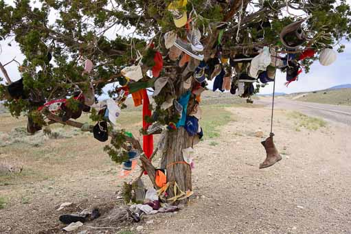
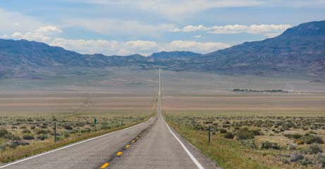
May, 2014 – We left the pristine alpine beauty of Lamoille Canyon outside Elko, Nevada, and promptly embarked on a 500 mile journey north and west to Oregon across some of the most remote and desolate landscapes we have ever seen.

Getting off the interstate (I-80) at Winnemucca, we knew we were entering less charted territory when we noticed that the town’s spelling was “Winnemocca” on the statewide map of Nevada in our Delorme Atlas but was “Winnemucca” on the close-up map.

Open Roads of Nevada

A wide open road in northern Nevada

We wanted to get gas and had seen signs on the interstate for big travel centers in Winnemucca but we never found them.

Instead, crossing the back side of Winnemucca to get onto our remote road to Oregon, all we saw were three small gas stations that looked very hard to get into.

So, we kept going. Continue reading

From Salt to Snow in Nevada – Bonneville to Lamoille Canyon

May, 2014 – We were flying high as we left Ely, Nevada, where we had been thrilled by the Nevada Open Road Challenge car races. With car racing on our minds, the only direction we could head from there was north, up to the Bonneville Salt Flats just over the Nevada border in Utah.

The Bonneville Salt Flats are a massive, natural expanse of crusty old table salt that is layered thickly on a valley floor and extends for miles west of Utah’s Great Salt Lake. They have long been used for attempting and setting land speed records.

Traveler's Tree on Route 93 Nevada

We discover a Traveler’s Tree on the open roads of Nevada

The road from Ely to the town of Wendover on the edge of the salt flats is a narrow ribbon that winds through vast empty valleys. It soon hypnotized me as we drove.

So I was jolted back to reality when Mark suddenly hit the brakes and pulled over, saying, “We’ve gotta check this out!” Continue reading

Nevada Open Road Challenge – A NEED for SPEED!

After our exciting slot canyon hike and our happy romps amid the beautiful wildflowers and “toadstools” just north of the Vermillion Cliffs in southern Utah, we put in some long hours on the road, driving north and west through Utah and into Nevada.

The roads in Utah were familiar and were loaded with memories as we passed through Kanab and the wonderful Best Friends Animal Sanctuary, on up through Panguitch and past its turn-offs for Zion National Park, Red Canyon, Bryce Canyon and Cedar Breaks.

Straight lonely highways in Nevada

This is Hayabusa country!

But when we got into Nevada we were in new territory.  The roads were straight and deserted, and the vast valleys on either side of us seemed to go on forever.  There wasn’t a building or car in sight all the way to the horizon in every direction.

“This is Hayabusa country,” Mark suddenly said.  “This would be so perfect for a fast motorcycle!” Continue reading

Paria Rimrocks “Toadstools” Hike to A Hidden Canyon!

Fields of wildflowers in Southern Utah

OMG – When we’re not looking, we come across a gorgeous field
of wildflowers bursting with color!

May, 2014 – All spring we had deliberately searched for wildflowers in Arizona, using the excellent book Wild Arizona as a guide.

We had driven down crazy back roads and hiked into the hinterlands, stalking these colorful little beauties.

We had found lots of pretty flowers scattered here and there, but the vast fields of color we’d hoped for never materialized. Continue reading

Wire Pass Trail – Slot Canyon Hiking!

Wire Pass Slot Canyon view from outside

The slot canyon is barely visible from the outside.

May, 2014 – The beautiful red rocks and views of Sedona, Arizona, are utterly enchanting, but the exotic Vermillion Cliffs two hundred miles north lured us away.

We have driven past the fantastically colored rock walls along routes 89 and 89A between Page, Arizona, and Kanab, Utah, many times in the past.

However, this time we stopped for a while to explore the area in a little more depth. Continue reading

Montezuma’s Castle & Schnebly Hill – Sedona Heights!

Montezuma's Castle National Monument

“Montezuma’s Castle” – were the Aztecs in Arizona??!!

May, 2014 – We have driven past those tantalizing signs on I-17 in Arizona a hundred times:
“Montezuma’s Castle” & “Montezuma’s Well.”

But we have always been in a rush either to get up to Flagstaff or down to Phoenix.

Did those signs refer to the 16th century Aztec king, Montezuma?

If so, what the heck had he been doing way up here in Arizona when his real castle was down by Mexico City?

If not, then why did these places bear his name? Continue reading

Sedona Reflections on the West Fork Trail

West Fork hike Sedona AZ

Beautiful reflections on the West Fork Trail

May, 2014 – Sedona, Arizona, is an outdoor lover’s paradise.  Not only were we thrilled (and challenged) by the wonderful mountain biking in the area, but the hiking was incredible too.

The only problem we had was figuring out which hikes to do! Continue reading

Sedona – Mountain biking in the red rocks!

Mountain bikes at Bell Rock Oak Creek AZ

Ready to Ride!!

May, 2014 – Sedona, Arizona, is a mountain biking mecca, and our friend Marcel, whom we met during our winter stay in Phoenix, and who inspired us to take up this sport, was eager to get us out on the trails.

The mountain biking in Sedona is scenic, dramatic and thrilling — but we soon found out that it is far from easy!

There is only one trail in the main system of in-town trails — the Bell Rock Pathway — that is truly for beginners, and we happily rode up and down that 3.5 mile path many times. Continue reading

Oh, Sedona – Scenic drives in the red rocks!!

Sedona Arizona sign

We have arrived!

May, 2014 – Driving north from Roosevelt Lake in the Phoenix area is a climb, no matter which road you take.

As we drove north on I-17, the rising elevation quickly took us out of the Sonoran desert landscapes.

The air cooled and the saguaro cactus gave way to scrubby evergreens.

In no time, we were in the heart of Arizona’s red rock country in Sedona.

Oh my.  Sedona is breathtaking!! Continue reading