On the road to Baker City, Oregon

Big Money Bank Dayville Oregon

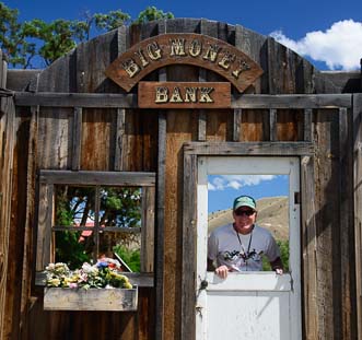
Mark greets patrons at the Big Money Bank

June 2014 – Leaving the John Day Fossil Beds National Monument behind and continuing our scenic drive to northeastern Oregon along Route 26, we passed through lots of small towns.  Each one celebrated the historic American West in its own way.

Still pondering the early 20th century sheep ranching lifestyle we had seen at the Monument, we came across a funny, fake old western town front in Dayville.

Rather than building a sheep ranching enterprise, perhaps the easiest way to make a fortune in the old west was to work at the Big Money Bank. Mark certainly thought so!

Miners' homes black and white

With the railway shut down, Whitney, Oregon, is now a ghost town.

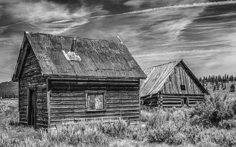
Another community we passed, named Whitney, was once a railroad town for the logging industry. Now it is a ghost town.

Rails extended in all directions from Whitney so that an immense stand of yellow pine could be harvested and shipped out on rail cars.

From 1901 to 1947 as many as 150 people called Whitney home.  Today only a handful of crumbling buildings remain.

Sumpter Railroad Oregon

The Sumpter Valley Railroad between Sumpter
and McEwen is still alive and well!

Further east in Sumpter, Oregon, we found the lovingly restored remnants of the same logging railroad line that had put Whitney on the map: the Sumpter Valley Railroad

This railway now offers excursion rides. From the brake man to the conductor to the engineer, all the positions are held by dedicated volunteers.

Mark at the wheel of Sumpter Railroad Oregon

The engineer gave Mark a turn in the driver’s seat.

Volunteers work for a few years to learn all the skills necessary to be advanced to the level of train engineer, and that was the goal of several volunteers we met.


Meadow of Lupine Sumpter Oregon

We came across a vast field of wildflowers.

The train goes only a few miles between Sumpter and McEwen, but it is a popular ride for young and old alike.

The engineer invited Mark to have a seat in front of the engine. What an antiquated mechanical marvel that is!

The old mechanics who worked on these kinds of engines back when they were still in commercial use are now passing their skills on to younger mechanics who are learning how to restore them and keep them running.

Lupine in the woods

Lupine were blooming in the woods nearby too!

Back on the road again, we saw snowy mountains beginning to appear on the horizon.

When we passed a field full of purple and white lupine, we had to stop for photographs!

Hay bales in Baker Oregon

Baker City is smack in the middle of beautiful farm and ranch land.

While we were both knee deep in flowers, a fellow driving by stopped his truck and walked over to us, saying, “I was hoping someone would photograph those flowers!”

Welcome to Baker City Oregon

Baker City’s small town charm is infectious.

We ended up chatting with him for quite a while, right there on the side of the road. He wasn’t in a hurry and neither were we!

We had arrived on the quieter side of Oregon.

Baker City is the biggest city for hundreds of miles around. How big is big? 10,000 people live there.

How fast is it growing? The population has hovered around 10,000 since 1940!

Baker City Oregon city streets

Baker City Oregon

Baker Tower in Baker City Oregon

Baker Tower is STILL Oregon’s highest building
east of the Cascades!

What a contrast to other western cities like Phoenix that is 23 times the size it was in 1940, or Bend Oregon that has quadrupled in just a few decades.

City Hall in Baker City Oregen

The grand buildings like City Hall
belie the small size of the population.

When I asked at the fabulous Baker Heritage Museum in town why things haven’t changed much over the years, I was told it’s because a lot of old timers like the city just the way it is.

If it ain’t broke, don’t fix it!

Grand Geiser Hotel Baker City Oregon

This small historic city oozes charm.

The nearest Walmart is 45 miles away, and there are no big box stores.

What really makes it special, though, besides its quiet, down to earth and friendly nature, is the beautiful Victorian arcthitecture all around town.

The Geiser Grand Hotel presides over downtown, along with the Baker Tower, the tallest building east of the Cascades.

Five pound gold nugget Baker City Oregon

Baker City was known as the “Queen of the mines” for good reason…

Keeping a lid on growth and resisting change doesn’t mean there’s no money around, however.

Northeast Oregon is the richest part of the state for gold, and the US Bank branch in town has a glass enclosed exhibit of gold nuggets that includes a fist-sized “nugget” that was found nearby in June, 1913.

The day after unearthing it, the two men who discovered it hopped on the Sumpter Valley Railroad (which was carrying passengers as well as logs by then) to take it to Baker City to have it appraised.

At 80.4 ounces (over 5 lbs.), it is one of the largest pure gold nuggets still in existence today (most others were melted down).

Adler House Baker City Oregon

Not all money came from gold and timber…
Magazine distribution magnate Leo Adler lived here.

At the time it was found, gold was about $18 an ounce, making it worth about $1,500 to those two lucky men.

Today, 99 years later, gold is worth over $1,300 per ounce, but as a collectible, this nugget is probably even more valuable.

One of the town’s most successful residents is Leo Adler who created a magazine distribution empire in the mid-1900’s.


Deer crossing Adler Path Baker City Oregon

A deer and his buddy surprise us on the bike path in town.

He started out by walking around town at age 9 carrying the Saturday Evening Post and Ladies Home Journal!

Young buck Baker City Oregon

They call this a city?!!

He loved Baker City, and he left the city a substantial sum, part of which has been used to create a paved bike path through town.

Fifth wheel trailer under a rainbow

What a soul-satisfying town
to call home for a while.

While we were riding on his namesake path one day, Mark saw a young buck nibbling leaves on a tree.

He trotted right between us!

We followed him and his buddy to a big field where they started grazing, totally unconcerned with our presence.

Such is life — one of peace and tranquility — in Baker City, Oregon.


Subscribe
Never miss a post — it’s free!

Here is a little more info for you about Baker City, and the Sumpter Valley Railroad.

<-Previous || Next->

More from our RV travels in Eastern Oregon:

Our most recent posts:

More of our Latest Posts are in the top MENU above.

Smoked out by a Wildfire!

Two Bulls Wildfire Bend Oregon June 2014

The Two Bulls fire created a mushroom cloud on Bend’s horizon

June, 2014 – We were having so much fun in Bend, Oregon,  that one night when we went to bed we joked that we’d probably stick around for another month.  Or maybe all summer!

The next afternoon the Two Bulls wildfire broke out about ten or so miles away.

Within 24 hours the smoke was choking our campsite.

Ironically, back at Crater Lake, we had stood in the snow on the rooftop of an overlook with some Oregon firefighters who told us they expected a very difficult fire season due to the scant snowfall over the winter. Continue reading

A Scenic Drive in Central Oregon

June, 2014 – Oregon is loaded with designated Scenic Drives, and a lot of these routes weave a web around central Oregon. During our stay in Bend, cruising friends of ours who were on a brief break from sailing the South Pacific on their boat Mazu invited us to visit. This was a perfect chance for us to check out the scenic roads along the McKenzie River that lie to the west of Bend.

Barn and mountain in Sisters Oregon

We got great scenery right away on our way to Sisters

As we approached the cute town of Sisters we were awarded with some spectacular views of snowcapped mountains hovering on the horizon. These mountains are the Three Sisters, bearing the names Faith, Hope and Charity.

They sit a tantalizing but frustrating distance away from the very lonely yet handsome Mount Bachelor who has been trying unsuccessfully to win their affections forever.

Our drive along the pretty McKenzie River took us first to Camp Sherman, a tiny and richly verdant village on the banks of the small Metolius River.

Camp Sherman Head of Metolius River Oregon

Camp Sherman is an evergreen riverside hideaway

Just a few miles from Camp Sherman we visited the headwaters of the Metolius River which spill forth from the side of a hill like a huge bubbler. The scientific debate about the origins of this water is intriguing in an academic kind of way, and we nodded with appropriate solemnity as we read the plaques about it all.

Chipmunk at the Head of the Metolius River

Well, hello there!

Chipmunk begging at Metolius River Oregon

These guys were professionals!

But what really captivated us at the viewing area were the chipmunks.

These cheeky little guys are very fond of people and they ran right up to us.

Suttle Lake Oregon

Come sit for a spell at Suttle Lake…

Well, “fond of people” isn’t quite accurate, as it is the snacks we people carry that they are after!

They sized us up in a heartbeat, and quickly wrote us off as being uselessly empty-handed and soon disappeared.

A little further west on our drive along Route 126 we stopped at Suttle Lake where we wandered among the flowers and took in the lake views.

The Lodge at Suttle Lake is a beautiful log structure with a huge and inviting great room that boasts a big stone hearth.

The Lodge at Suttle Lake Oregon

The lodge was spacious and airy yet cozy at the same time.

Starburst thru a purple flower

Starburst through a flower!

Lavender Wildflower at Suttle Lake Oregon

Mark found this beautiful wildflower.


The Lodge at Suttle Lake Oregon deck

View from the deck of The Lodge at Suttle Lake

Out on the raised lawn there is an elegant deck with patio seating that overlooks the lake.

Mark spent quite a bit of time among the flowers and came away with some magnificent photos.


Leaving Suttle Lake and carrying on our explorations further west, we came to Sahalie Falls.

Sahalie Falls Trail Oregon

A stream-side hike at Sahalie Falls brought us to this view.

Oregon is known for its stunning and varied waterfalls, but Sahalie Falls will always stand out in our memories as particularly majestic.

We heard the big cascade from the parking lot before we even saw it, and as we descended the stone stairs on the path, a blast of cold air swept across us.

Sahalie Falls Oregon

Sahalie Falls

Sahalie Falls and Us Oregon

Happy campers

The stairs are lined with hewn log rails that are covered so thickly in moss and ivy that they are a rich, moist dark green that is alive to the touch.

At the bottom of the stairs a wonderful rainforest hiking trail winds over roots and between ferns along the river’s edge.

Here the falls rush along in splashy, noisy rapids that tumble and crash over the rocks in a big rush to get downstream.

Good Pasture Covered Bridge Oregon

Good Pasture Covered Bridge is the longest continually used covered bridge in Oregon!

Hopping back in the truck, Route 126 took us further west along the McKenzie River, passing by the historic Good Pasture Bridge.

This covered bridge is the second longest in Oregon, and the longest one that has been in continual use since it was built.

We learned that, back in the day, bridges were built with walls and a roof so horses would walk across without shying.


Good Pasture Covered Bridge and 1959 Corvette

And here comes a 1959 Corvette!

How fun to watch a pristine 1959 Corvette convertible come through the bridge towards us!


Our friends took us to the Leaburg fish hatchery where trout and other fish are raised to stock the area rivers and lakes.

Seeing the jumble of fish in the water was interesting, but the best part was when an osprey silently swooped down and grabbed a fish out of a tank in its talons.

Soaring osprey

There’s nothing like a free lunch!

He took his catch up in a tree to enjoy lunch with a view!

Two routes cross the Cascades west of Bend, the Santiam Pass (Route 126) we had just driven and the McKenzie Pass (Route 280) we had not yet seen.

For one month each spring the McKenzie Pass Scenic Byway is opened strictly to bicycle traffic. We hit it with our mountain bikes on the last day that bikes ruled the road.

Unicycle on McKenzie Pass Oregon

Riding our bikes up steep McKenzie Pass we were humbled to
see a guy doing it on a unicycle!!

After a long grind to the top and a screaming descent back down to the bottom, we noticed a fellow doing the ride on a unicycle.

This wasn’t his first time either. He told us he’d ridden to the summit on his unicycle each weekend since the route opened to bikes four weeks earlier. What’s more, he was part of a unicycling mountain bike club.

And here we’d been patting ourselves on the back for conquering McKenzie Pass and romping around the area’s mountain biking trails on our two wheeled bikes.

Without a doubt, the area around Bend, Oregon, was continuing to impress us with its gorgeous rivers, streams and lakes and its vigorous and irreverent spirit!


<– Previous Post: Lakes & Rivers in Bend, Oregon………………………………..Smoked Out by a Wildfire! Next Post –>

New to this site? Visit our Home page to read more about our full-time traveling lifestyle and find out where we keep all the good stuff. If you like what you see, we'd love for you to subscribe to receive our latest posts!


From Lakes to Rivers in Bend Oregon

June, 2014 – We had dashed across Nevada and Oregon, zipped through Crater Lake, and come to central Oregon because we had mountain biking on our minds. Bend, Oregon, is reputed to be one of the biggest mountain biking meccas around, and we were eager to get out on the trails and give it a try. First we got our feet wet…well, we whetted our appetites, I should say, at Diamond Lake.

Diamond Lake Mountain biking

On the jetty at Diamond Lake

Continue reading

Crater Lake National Park in Oregon – Bluer than blue!

May, 2014 – After recovering from our mad dash across northern Nevada and southern Oregon, our first priority was to visit Crater Lake National Park. We had heard about this beautiful park many times over the years, and now we were blessed with the most perfect weather to go see it on the Saturday of Memorial Day Weekend.

Waist deep snow at Crater Lake

Wow – the snow is waist deep!

As we approached the park, we suddenly found ourselves driving between banks of snow.

We had seen ankle deep snow in lovely Lamoille Canyon back in Nevada, but this stuff was waist deep! Continue reading

Into the Great Wide Open – Nevada to Oregon

May, 2014 – We left the pristine alpine beauty of Lamoille Canyon outside Elko, Nevada, and promptly embarked on a 500 mile journey north and west to Oregon across some of the most remote and desolate landscapes we have ever seen.

Getting off the interstate (I-80) at Winnemucca, we knew we were entering less charted territory when we noticed that the town’s spelling was “Winnemocca” on the statewide map of Nevada in our Delorme Atlas but was “Winnemucca” on the close-up map.

Open Roads of Nevada

A wide open road in northern Nevada

We wanted to get gas and had seen signs on the interstate for big travel centers in Winnemucca but we never found them.

Instead, crossing the back side of Winnemucca to get onto our remote road to Oregon, all we saw were three small gas stations that looked very hard to get into.

So, we kept going. Continue reading

From Salt to Snow in Nevada – Bonneville to Lamoille Canyon

May, 2014 – We were flying high as we left Ely, Nevada, where we had been thrilled by the Nevada Open Road Challenge car races. With car racing on our minds, the only direction we could head from there was north, up to the Bonneville Salt Flats just over the Nevada border in Utah.

The Bonneville Salt Flats are a massive, natural expanse of crusty old table salt that is layered thickly on a valley floor and extends for miles west of Utah’s Great Salt Lake. They have long been used for attempting and setting land speed records.

Traveler's Tree on Route 93 Nevada

We discover a Traveler’s Tree on the open roads of Nevada

The road from Ely to the town of Wendover on the edge of the salt flats is a narrow ribbon that winds through vast empty valleys. It soon hypnotized me as we drove.

So I was jolted back to reality when Mark suddenly hit the brakes and pulled over, saying, “We’ve gotta check this out!” Continue reading

Nevada Open Road Challenge – A NEED for SPEED!

After our exciting slot canyon hike and our happy romps amid the beautiful wildflowers and “toadstools” just north of the Vermillion Cliffs in southern Utah, we put in some long hours on the road, driving north and west through Utah and into Nevada.

The roads in Utah were familiar and were loaded with memories as we passed through Kanab and the wonderful Best Friends Animal Sanctuary, on up through Panguitch and past its turn-offs for Zion National Park, Red Canyon, Bryce Canyon and Cedar Breaks.

Straight lonely highways in Nevada

This is Hayabusa country!

But when we got into Nevada we were in new territory.  The roads were straight and deserted, and the vast valleys on either side of us seemed to go on forever.  There wasn’t a building or car in sight all the way to the horizon in every direction.

“This is Hayabusa country,” Mark suddenly said.  “This would be so perfect for a fast motorcycle!” Continue reading

Paria Rimrocks “Toadstools” Hike to A Hidden Canyon!

Fields of wildflowers in Southern Utah

OMG – When we’re not looking, we come across a gorgeous field
of wildflowers bursting with color!

May, 2014 – All spring we had deliberately searched for wildflowers in Arizona, using the excellent book Wild Arizona as a guide.

We had driven down crazy back roads and hiked into the hinterlands, stalking these colorful little beauties.

We had found lots of pretty flowers scattered here and there, but the vast fields of color we’d hoped for never materialized. Continue reading

Wire Pass Trail – Slot Canyon Hiking!

Wire Pass Slot Canyon view from outside

The slot canyon is barely visible from the outside.

May, 2014 – The beautiful red rocks and views of Sedona, Arizona, are utterly enchanting, but the exotic Vermillion Cliffs two hundred miles north lured us away.

We have driven past the fantastically colored rock walls along routes 89 and 89A between Page, Arizona, and Kanab, Utah, many times in the past.

However, this time we stopped for a while to explore the area in a little more depth. Continue reading