July 2014 – A wildfire in beautiful Hurricane Creek in Oregon’s Eagle Cap Wilderness just a few miles from Joesph, Oregon, spurred us to begin packing up and moving on. Looking at the statue of Chief Joseph, leader of the Nez Perce tribe, in the center of town, as thick smoke rose from behind the mountains at his back, I wondered what he would think of wildfires in his beloved Wallowa mountains.

What would Chief Joseph think of the white man’s land management today?
The discovery of gold on his tribe’s homeland in 1863 led to the forcible removal of his people from this gorgeous land. He argued with eloquence, grace and dignity before the American leaders of the day for equal treatment of all men under fair laws.
How tragic that Lincoln’s recently declared Emancipation Proclamation said the same thing but Chief Joseph’s impassioned pleas were ignored.

A pretty church in Halfway, Oregon.
Wholly consumed with thoughts of gold, cattle grazing and game hunting, no one of that time could possibly have anticipated just how massive and mechanized the American population would become or the kind of pressure all this humanity would put on the land. Since that era just 150 years ago, America has grown by 750%.

The Snake River
In one of the country’s least populated areas, east of Joseph, Oregon, the Snake River has carved America’s deepest gorge: Hell’s Canyon. Cliffs rise as high as 8,000 feet on either side.

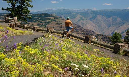
Wallowa Mountain Loop road (Route 39), a twisty National Forest road, runs from Joseph out to Hell’s Canyon Overlook where we got a peak at Idaho’s Seven Devils Mountains that line the gorge.

Hell’s Canyon Overlook – No river in sight!
This is a winding 45 mile drive, and although the views across the canyon were vast, it didn’t give us the perspective on the gorge we had expected.

Hell’s Canyon as seen from the shoreside road!


I just love a curvy road!
For those views, we had to take a 150 mile detour back through Baker City to avoid the Wallowa Loop Road construction with our buggy.

This one lies on the shores of Hell’s Canyon!
We stopped in the little town of Halfway and admired their very cute red church, and continued on to Copperfield at the base of Hell’s Canyon.

A memorable visit to a beautiful place.
Unlike the Hell’s Canyon Overlook that peers across the top of canyon, the Hell’s Canyon National Recreation Area offers dramatic scenery and lots of adventure between the canyon walls. We found loads of inspiring views to keep our cameras happy.

People were playing in boats and tubes and standup paddle-boards on the river.
There were boaters playing on the water, fisherman casting their lines, and we even found a tiny private sandy beach tucked along the shoreline.
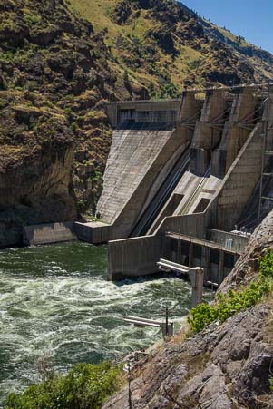
From our first glimpse of Hell’s Canyon at Copperfield, we drove north along the Idaho side of the gorge to the end of the road at Hell’s Canyon Dam.

Snooping around on the banks we discovered a tiny, private, sand beach!
This is one of fifteen dams constructed for various purposes along the Snake River, and it is one of three dams in Hell’s Canyon that were built to produce electricity and control flooding.

Evidence of progress in the form of electricity and flood control, but the “dam thing” blocks the progress of salmon!
Like anything that interferes with the processes of nature, these dams have had unanticipated effects. The Snake River used to be a major salmon run for three different species of salmon that spawned far inland upriver but spent most of their lives in ocean. They’d wait until their last year of life to swim back upriver and spawn the next generation of fish.


A deer looks up while Mark takes his photo.
Unfortunately, those aging salmon can no longer swim past the dams to spawn, so the ones that mistakenly swim up the Snake River this far end up trapped at the dam.

Hopefully all those grasses will fatten this guy up!
The National Forest Service rangers at the dam told us that because of this salmon roadblock, Hell’s Canyon Dam is an awesome place to go fishing.
They said that over Memorial Day weekend this year, the river was absolutely boiling with fish, and the banks were throbbing with fishermen!
What would Chief Joseph think of that?

Farm land, prairie and the Wallowa mountains in eastern Oregon.
I don’t know, but after seeing this part of the world, I understand why he loved this land so dearly.
______________________
Here are some links for more information on Hell’s Canyon National Recreation Area (more here), the Snake River and its dams as well as RV parking options in Copperfield, Oregon.
Subscribe
Never miss a post — it’s free!
<-Previous || Next->
More from our RV travels in Eastern Oregon:
- Hurricane Creek Wildflowers – Enterprise OR 07/30/14
- Wallowa Lake Tramway – Into the Alps! 07/23/14
- Joseph Branch Railriders – What a ride! 07/19/14
- Joseph, Oregon – At Heaven’s Door! 07/15/14
- Baker City Cycling Classic 07/11/14
- On the road to Baker City, Oregon 07/08/14
Our most recent posts:
- Beehive Trail in Arizona – A “Mini Wave” hike by Lake Powell 07/19/24
- Reese Goose Box Review: 20K Gen 3 TESTED + How to Hitch 06/27/24
- Lake Powell – Heart of Glen Canyon National Recreation Area 05/10/24
- Quick Release Pull Pins for Fifth Wheel Landing Jacks – YES! 05/03/24
- Sheep May Safely Graze (in the Mountains with Dogs!) 04/26/24
More of our Latest Posts are in the top MENU above.
